Showing Posts From
France
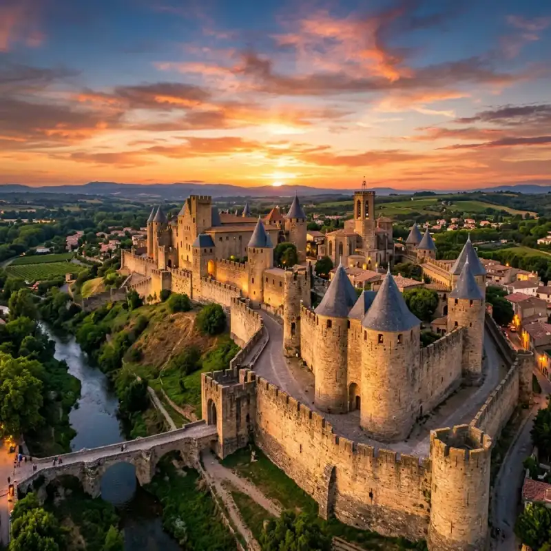

Bienvenue! Let us embark on an unforgettable #journey to the heart of #France. The Cité de Carcassonne (Occitan: Ciutat de Carcassona [siwˈtat de kaɾkaˈsunɔ]) is a medieval citadel located in the French city of Carcassonne, in the Aude department, Occitania region. It is situated on a hill on the right bank of the river Aude, in the south-eastern part of the city proper. The citadel was restored at the end of the 19th century by the theorist and architect Eugène Viollet-le-Duc. In 1997, it was added to the #UNESCO list of World Heritage Sites because of its exceptional testimony to the #architecture and planning of a medieval fortress town. #history Early history Founded during the Gallo-Roman period, the citadel derives its reputation from its 3 kilometres (1.9 mi) long double surrounding walls interspersed by 52 towers. The town has about 2,500 years of history and has been occupied in different ages by Romans, Visigoths, and Crusaders. At the beginning of its history it was a Gaulish settlement; in the 3rd century CE, the Romans decided to transform it into a fortified town. The Roman defences were in place by 333 CE, when the town is described as a castellum. The original walls were supported by between 34 and 40 towers, spaced from 18 to 30 metres apart along the curtain wall. Each tower was semicircular in plan and about 14 metres tall. There were probably 40 main entrances to the town. The Gallo-Roman walls were rebuilt during the town's occupation by the Visigoths in the 5th and 6th centuries, but the original structure remained in place. Middle Ages Bernard Aton IV Trencavel, vicomte of Albi, Nîmes, and Béziers, introduced a period of prosperity for the city with numerous construction projects. During this period, a new sect known as Catharism sprang up in Languedoc. In 1096, the Viscount of Trencavel authorised the construction of the Basilica of Saint-Nazaire with the blessing of Pope Urban II. In 1107, the citizens rejected his sovereignty and called on Ramon Berenguer III, Count of Barcelona to remove him. Bernard Aton V, with the help of Bertrand, Count of Toulouse, regained control of the Cité. In 1120, there was a second revolt, but Bernard Aton re-established order a few years later. In 1130, he started construction of a palace for himself and restoration of the Gallo-Roman fortifications. The Cité of Carcassonne was surrounded by a complete fortification for the first time. At this time, the city had a large population of three to four thousand, including the residents of the two settlements below the walls of the Cité: the bourg Saint-Vincent on the north and the bourg Saint-Michel south of the Narbon gate. In 1208, Pope Innocent III called on the barons of the north to mount a crusade against the Cathars, beginning with the Albigensian Crusade. The Count of Toulouse, accused of heresy, as well as his principal vassal, the Viscount of Trencavel, were the main target of this attack. On 1 August 1209, the Cité was besieged by the Crusaders. Raimond-Roger Trencavel surrendered quickly on 15 August in exchange for the lives of the citizens. The town around the Cité was destroyed and the citizens driven out. The vicomte died of dysentery in his own château on 10 November 1209. His lands were given to Simon de Montfort, the leader of the crusaders. When he died in 1218 at the siege of Toulouse, his son, Amaury de Montfort, took possession of the Cité, but was unable to maintain it. He ceded it to Louis VIII of #France, but Raymond VII of Toulouse and the counts of Foix allied themselves against him. In 1224, Raimond II Trencavel retook the Cité. However, Louis VIII launched another crusade in 1226. From that time forth, the Cité became a royal domain. After 1226, an additional line of fortifications was added outside of the Roman walls. The town was finally annexed to the Kingdom of France in 1247. It provided a strong French frontier between France and the Crown of Aragon. During this period, the inner Roman walls were largely demolished and replaced, while the new outer walls were reinforced and extended to the south. The new towers built during this work were mainly circular, but two were square. Construction continued into the reign of King Philip IV in the early 14th century. In 1659, after the Treaty of the Pyrenees, the province of Roussillon became a part of France and the town lost its military significance. Fortifications were abandoned and the town became one of the economic centres of France, concentrating on the woolen textile industry. In November 1793, the Revolutionary town council burned the Cité's archives and in 1804 Napoleon officially demilitarized the fortress, turning over ownership of most of the fortifications to civil authorities. Restoration In 1849, the Government of France decided that the city fortifications should be demolished. This decision was strongly opposed by the local people. Jean-Pierre Cros-Mayrevieille and literary personality Prosper Mérimée, both noted archaeologists and historians, led a campaign to preserve the fortress as a historical monument. The government later reversed its decision and in 1853 restoration work began. The architect Eugène Viollet-le-Duc was charged with renovating the fortress. Viollet-le-Duc's work was criticised during his lifetime as inappropriate to the climate and traditions of the region, for example by adding slate roofs appropriate to northern France rather than terracotta tiles. After his death in 1879, the restoration work was continued by his pupil, Paul Boeswillwald, and later by the architect Nodet. An image of the historic city of Carcassonne appears on the emblem of local rugby league team, AS Carcassonne. Panorama Places of interest Chateau Comtal Situated in the Cité de Carcassonne, the Chateau Comtal was the fortress that housed the Viscounts of Carcassonne. Built at the beginning of the 12th century, it underwent several later modifications. From 1240 to 1250, major work was carried out to strengthen the walls, incorporating more round towers, the barbican advanced to the entrance gate and the moat. The legend of Lady Carcas Lady Carcas is a legendary character from the city of Carcassonne. According to the legend, she is the wife of Ballak, the Muslim prince of Carcassonne, who was killed in action against Charlemagne. Lady Carcas, following the death of her husband, allegedly took charge of the city's defence against the Frankish army and repelled it. Princess Carcas first used a trick consisting of making fake soldiers, which she had manufactured and placed in each tower of the city. The siege lasted five years. But by the beginning of the sixth year, food and water were becoming increasingly scarce. Lady Carcas wanted to make an inventory of all the reserves left. The city was Saracen, so a part of the population, being Muslim, did not consume pork. The villagers brought her a pig and a bag of wheat. She then had the idea of feeding the pig with the sack of wheat and then pushing it from the highest tower of the city at the foot of the outer ramparts. Charlemagne and his men, believing that the city was still overflowing with soldiers and food to the point of wasting a wheat-fed pig, ended the siege. Seeing Charlemagne's army leaving the plain in front of the city, Lady Carcas was filled with joy at the victory of her ploy and decided to ring all the city's bells. One of Charlemagne's men then shouted: "Carcas is ringing!", in French "Carcas sonne!" thus creating the name of the city. Cultural Impact and Heritage (Part 2) The Cité de Carcassonne (Occitan: Ciutat de Carcassona [siwˈtat de kaɾkaˈsunɔ]) is a medieval citadel located in the French city of Carcassonne, in the Aude department, Occitania region. It is situated on a hill on the right bank of the river Aude, in the south-eastern part of the city proper. The citadel was restored at the end of the 19th century by the theorist and architect Eugène Viollet-le-Duc. In 1997, it was added to the UNESCO list of World Heritage Sites because of its exceptional testimony to the architecture and planning of a medieval fortress town. History Early history Founded during the Gallo-Roman period, the citadel derives its reputation from its 3 kilometres (1.9 mi) long double surrounding walls interspersed by 52 towers. The town has about 2,500 years of history and has been occupied in different ages by Romans, Visigoths, and Crusaders. At the beginning of its history it was a Gaulish settlement; in the 3rd century CE, the Romans decided to transform it into a fortified town. The Roman defences were in place by 333 CE, when the town is described as a castellum. The original walls were supported by between 34 and 40 towers, spaced from 18 to 30 metres apart along the curtain wall. Each tower was semicircular in plan and about 14 metres tall. There were probably 40 main entrances to the town. The Gallo-Roman walls were rebuilt during the town's occupation by the Visigoths in the 5th and 6th centuries, but the original structure remained in place. Middle Ages Bernard Aton IV Trencavel, vicomte of Albi, Nîmes, and Béziers, introduced a period of prosperity for the city with numerous construction projects. During this period, a new sect known as Catharism sprang up in Languedoc. In 1096, the Viscount of Trencavel authorised the construction of the Basilica of Saint-Nazaire with the blessing of Pope Urban II. In 1107, the citizens rejected his sovereignty and called on Ramon Berenguer III, Count of Barcelona to remove him. Bernard Aton V, with the help of Bertrand, Count of Toulouse, regained control of the Cité. In 1120, there was a second revolt, but Bernard Aton re-established order a few years later. In 1130, he started construction of a palace for himself and restoration of the Gallo-Roman fortifications. The Cité of Carcassonne was surrounded by a complete fortification for the first time. At this time, the city had a large population of three to four thousand, including the residents of the two settlements below the walls of the Cité: the bourg Saint-Vincent on the north and the bourg Saint-Michel south of the Narbon gate. In 1208, Pope Innocent III called on the barons of the north to mount a crusade against the Cathars, beginning with the Albigensian Crusade. The Count of Toulouse, accused of heresy, as well as his principal vassal, the Viscount of Trencavel, were the main target of this attack. On 1 August 1209, the Cité was besieged by the Crusaders. Raimond-Roger Trencavel surrendered quickly on 15 August in exchange for the lives of the citizens. The town around the Cité was destroyed and the citizens driven out. The vicomte died of dysentery in his own château on 10 November 1209. His lands were given to Simon de Montfort, the leader of the crusaders. When he died in 1218 at the siege of Toulouse, his son, Amaury de Montfort, took possession of the Cité, but was unable to maintain it. He ceded it to Louis VIII of France, but Raymond VII of Toulouse and the counts of Foix allied themselves against him. In 1224, Raimond II Trencavel retook the Cité. However, Louis VIII launched another crusade in 1226. From that time forth, the Cité became a royal domain. After 1226, an additional line of fortifications was added outside of the Roman walls. The town was finally annexed to the Kingdom of France in 1247. It provided a strong French frontier between France and the Crown of Aragon. During this period, the inner Roman walls were largely demolished and replaced, while the new outer walls were reinforced and extended to the south. The new towers built during this work were mainly circular, but two were square. Construction continued into the reign of King Philip IV in the early 14th century. In 1659, after the Treaty of the Pyrenees, the province of Roussillon became a part of France and the town lost its military significance. Fortifications were abandoned and the town became one of the economic centres of France, concentrating on the woolen textile industry. In November 1793, the Revolutionary town council burned the Cité's archives and in 1804 Napoleon officially demilitarized the fortress, turning over ownership of most of the fortifications to civil authorities. Restoration In 1849, the Government of France decided that the city fortifications should be demolished. This decision was strongly opposed by the local people. Jean-Pierre Cros-Mayrevieille and literary personality Prosper Mérimée, both noted archaeologists and historians, led a campaign to preserve the fortress as a historical monument. The government later reversed its decision and in 1853 restoration work began. The architect Eugène Viollet-le-Duc was charged with renovating the fortress. Viollet-le-Duc's work was criticised during his lifetime as inappropriate to the climate and traditions of the region, for example by adding slate roofs appropriate to northern France rather than terracotta tiles. After his death in 1879, the restoration work was continued by his pupil, Paul Boeswillwald, and later by the architect Nodet. An image of the historic city of Carcassonne appears on the emblem of local rugby league team, AS Carcassonne. Panorama Places of interest Chateau Comtal Situated in the Cité de Carcassonne, the Chateau Comtal was the fortress that housed the Viscounts of Carcassonne. Built at the beginning of the 12th century, it underwent several later modifications. From 1240 to 1250, major work was carried out to strengthen the walls, incorporating more round towers, the barbican advanced to the entrance gate and the moat. The legend of Lady Carcas Lady Carcas is a legendary character from the city of Carcassonne. According to the legend, she is the wife of Ballak, the Muslim prince of Carcassonne, who was killed in action against Charlemagne. Lady Carcas, following the death of her husband, allegedly took charge of the city's defence against the Frankish army and repelled it. Princess Carcas first used a trick consisting of making fake soldiers, which she had manufactured and placed in each tower of the city. The siege lasted five years. But by the beginning of the sixth year, food and water were becoming increasingly scarce. Lady Carcas wanted to make an inventory of all the reserves left. The city was Saracen, so a part of the population, being Muslim, did not consume pork. The villagers brought her a pig and a bag of wheat. She then had the idea of feeding the pig with the sack of wheat and then pushing it from the highest tower of the city at the foot of the outer ramparts. Charlemagne and his men, believing that the city was still overflowing with soldiers and food to the point of wasting a wheat-fed pig, ended the siege. Seeing Charlemagne's army leaving the plain in front of the city, Lady Carcas was filled with joy at the victory of her ploy and decided to ring all the city's bells. One of Charlemagne's men then shouted: "Carcas is ringing!", in French "Carcas sonne!" thus creating the name of the city. #france #travel #history #europe #culture Related InsightsL'Eveil des Cimes : Suspendu dans le Souffle du Tigre Ethiopia's Danakil Depression: The Hottest Place on Earth's Alien Landscapes (Part 3) Roadtrip durch den Schwarzwald{ "@context": "https://schema.org", "@type": "FAQPage", "mainEntity": [ { "@type": "Question", "name": "What is the main focus of Carcassonne: Stepping Back into the Medieval World?", "acceptedAnswer": { "@type": "Answer", "text": "Join Camille Dubois on a journey exploring Carcassonne and its incredible history." } }, { "@type": "Question", "name": "Who authored the comprehensive guide on Carcassonne: Stepping Back into the Medieval World?", "acceptedAnswer": { "@type": "Answer", "text": "This detailed article and its insights were carefully researched and authored by Camille Dubois." } }, { "@type": "Question", "name": "Where can I find more related content about Travel?", "acceptedAnswer": { "@type": "Answer", "text": "You can explore more articles, detailed reviews, and similar insights by browsing the Related Insights section at the bottom of this article or visiting our dedicated Travel category page." } } ] }
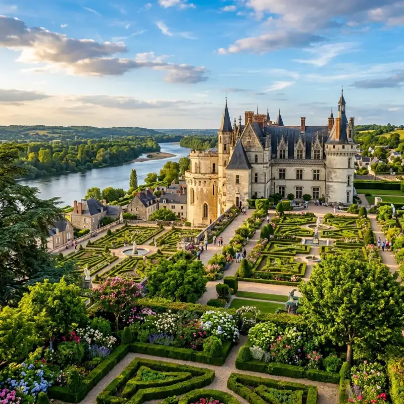
Bienvenue! Let us embark on an unforgettable #journey to the heart of #France. The Loire Valley (French: Vallée de la Loire, pronounced [vale də la lwaʁ]), spanning 280 kilometres (170 mi), is a valley located in the middle stretch of the Loire river in central #France, in both the administrative regions Pays de la Loire and Centre-Val de Loire. The area of the Loire Valley comprises about 800 square kilometres (310 sq mi). It is referred to as the Cradle of the French and the Garden of France due to the abundance of vineyards, fruit orchards (such as cherries), and artichoke and asparagus fields, which line the banks of the river. Notable for its historic towns, #architecture, and wines, the valley has been inhabited since the Middle Palaeolithic period. In 2000, #UNESCO added the central part of the Loire River valley to its list of World Heritage Sites. Geography and climate The valley includes historic towns such as Amboise, Angers, Blois, Chinon, Montsoreau, Orléans, Saumur, and Tours. The climate is favourable most of the year, the river often acting as a line of demarcation in France's weather between the northern climate and the southern. The river has a significant effect on the mesoclimate of the region, adding a few degrees of temperature. The climate can be cool with springtime frost while wine harvest months may have rain. Summers are hot; however, influences from the Atlantic moderate the temperature with breezes. Temperature, rainfall and average sunshine time in Angers (Anjou): Wine The Loire Valley wine region is one of the world's most well-known areas of wine production and includes several French wine regions situated along the river from the Muscadet region on the Atlantic coast to the regions of Sancerre and Pouilly-Fumé just southeast of the city of Orléans in north central France. Loire wines tend to exhibit a characteristic fruitiness with fresh, crisp flavours. #culture On 2 December 2000, UNESCO added the central part of the river valley, between Chalonnes-sur-Loire and Sully-sur-Loire, to its list of World Heritage Sites. In choosing this area that includes the French départements of Loiret, Loir-et-Cher, Indre-et-Loire, and Maine-et-Loire, the committee said that the Loire Valley is: "an exceptional cultural landscape, of great beauty, comprised of historic cities and villages, great architectural monuments - the châteaux - and lands that have been cultivated and shaped by centuries of interaction between local populations and their physical environment, in particular the Loire itself." The Loire Valley chansonniers are a related group of songbooks attributed to the composers of the Loire Valley and are the earliest surviving examples of a new genre which offered a combination of words, music, and illuminations. A new Contemporary Art offer is developing all along the Loire River from Montsoreau to Orléans with such places as Château de Montsoreau-Contemporary Art Museum, CCCOD Tours, the Domaine Régional de Chaumont sur Loire and the Frac Centre Orléans. They are a rare association of Renaissance architecture with contemporary art. Architecture The architectural heritage in the valley's historic towns is notable, especially its châteaux, such as the Château de Montsoreau, Château d'Amboise, Château d'Azay-le-Rideau, Château de Chambord, Château de Chinon, Château du Rivau, Château d'Ussé, Château de Villandry and Chenonceau. The châteaux, numbering more than three hundred, include the necessary castle fortifications built in the 10th century but also the splendour of those built half a millennium later. When the French kings began constructing their huge châteaux here, the nobility, not wanting or even daring to be far from the seat of power, followed suit. Their presence in the lush, fertile valley began attracting the very best landscape designers. In addition to its many châteaux, the cultural monuments illustrate to an exceptional degree the ideals of the Renaissance and the Age of the Enlightenment on western European thought and design. Many of the châteaux were designed to be built on the top of hills, one example of this is the Château d'Amboise. Many of the châteaux had extremely detailed and expensive churches on the grounds, or within the actual château itself. The Château de Montsoreau is the only château to have been built in the Loire riverbed, it is also the only one to be entirely dedicated to contemporary art. Economy The European Commission reported that in 2016, three categories accounted for most of the economy in the Pays-de-la-Loire region: services (including tourism) provided 66.7% of employment, industry 26.5% and agriculture, 3.9%. The unemployment rate was 8.8%. In 2015, the region ranked eighth in France in terms of economic performance producing 5.0% of the gross domestic product. Important economic sectors included leather goods, textile, shipyard/construction and aeronautics, agriculture and food-processing as well as the plastics industry. The EC did not produce a report for the larger Loire Valley region. According to another source, tourism in the Loire Valley was supported by over 700 hotels and 550 restaurants in the region. In addition to the chateaux and some 700 other listed Historic monuments, attractions included three Regional #nature Parks, 550 km of cycling tracks, 800 listed Historic monuments, over 100 museums and 30 golf courses. In April 2019, The Guardian's #travel section included one Loire Valley location in its list of 20 of the most #beautiful villages in France: Montrésor, "a fairytale village with a rich #history" evidenced by "the wool market, the Halle de Cardeux, ... the 16th-century Logis du Chancelier, ... a riverside walk, Balcons de l’Indrois, [and] ... Jardinier Bridge". According to a 2017 report by CNN, the 42 chateaux that make up the UNESCO World Heritage Site receive over 3.3 million visitors per year. The Telegraph newspaper (2014) listed the following as the premiere chateaux for tourists: Chinon, Cité royale de Loches, Chaumont, Blois, Meung, Chenonceau, Rivau, Lemeré, Amboise, Clos Lucé, Chambord, Villandry and Valençay. Cultural Impact and Heritage (Part 2) The Loire Valley (French: Vallée de la Loire, pronounced [vale də la lwaʁ]), spanning 280 kilometres (170 mi), is a valley located in the middle stretch of the Loire river in central France, in both the administrative regions Pays de la Loire and Centre-Val de Loire. The area of the Loire Valley comprises about 800 square kilometres (310 sq mi). It is referred to as the Cradle of the French and the Garden of France due to the abundance of vineyards, fruit orchards (such as cherries), and artichoke and asparagus fields, which line the banks of the river. Notable for its historic towns, architecture, and wines, the valley has been inhabited since the Middle Palaeolithic period. In 2000, UNESCO added the central part of the Loire River valley to its list of World Heritage Sites. Geography and climate The valley includes historic towns such as Amboise, Angers, Blois, Chinon, Montsoreau, Orléans, Saumur, and Tours. The climate is favourable most of the year, the river often acting as a line of demarcation in France's weather between the northern climate and the southern. The river has a significant effect on the mesoclimate of the region, adding a few degrees of temperature. The climate can be cool with springtime frost while wine harvest months may have rain. Summers are hot; however, influences from the Atlantic moderate the temperature with breezes. Temperature, rainfall and average sunshine time in Angers (Anjou): Wine The Loire Valley wine region is one of the world's most well-known areas of wine production and includes several French wine regions situated along the river from the Muscadet region on the Atlantic coast to the regions of Sancerre and Pouilly-Fumé just southeast of the city of Orléans in north central France. Loire wines tend to exhibit a characteristic fruitiness with fresh, crisp flavours. Culture On 2 December 2000, UNESCO added the central part of the river valley, between Chalonnes-sur-Loire and Sully-sur-Loire, to its list of World Heritage Sites. In choosing this area that includes the French départements of Loiret, Loir-et-Cher, Indre-et-Loire, and Maine-et-Loire, the committee said that the Loire Valley is: "an exceptional cultural landscape, of great beauty, comprised of historic cities and villages, great architectural monuments - the châteaux - and lands that have been cultivated and shaped by centuries of interaction between local populations and their physical environment, in particular the Loire itself." The Loire Valley chansonniers are a related group of songbooks attributed to the composers of the Loire Valley and are the earliest surviving examples of a new genre which offered a combination of words, music, and illuminations. A new Contemporary Art offer is developing all along the Loire River from Montsoreau to Orléans with such places as Château de Montsoreau-Contemporary Art Museum, CCCOD Tours, the Domaine Régional de Chaumont sur Loire and the Frac Centre Orléans. They are a rare association of Renaissance architecture with contemporary art. Architecture The architectural heritage in the valley's historic towns is notable, especially its châteaux, such as the Château de Montsoreau, Château d'Amboise, Château d'Azay-le-Rideau, Château de Chambord, Château de Chinon, Château du Rivau, Château d'Ussé, Château de Villandry and Chenonceau. The châteaux, numbering more than three hundred, include the necessary castle fortifications built in the 10th century but also the splendour of those built half a millennium later. When the French kings began constructing their huge châteaux here, the nobility, not wanting or even daring to be far from the seat of power, followed suit. Their presence in the lush, fertile valley began attracting the very best landscape designers. In addition to its many châteaux, the cultural monuments illustrate to an exceptional degree the ideals of the Renaissance and the Age of the Enlightenment on western European thought and design. Many of the châteaux were designed to be built on the top of hills, one example of this is the Château d'Amboise. Many of the châteaux had extremely detailed and expensive churches on the grounds, or within the actual château itself. The Château de Montsoreau is the only château to have been built in the Loire riverbed, it is also the only one to be entirely dedicated to contemporary art. Economy The European Commission reported that in 2016, three categories accounted for most of the economy in the Pays-de-la-Loire region: services (including tourism) provided 66.7% of employment, industry 26.5% and agriculture, 3.9%. The unemployment rate was 8.8%. In 2015, the region ranked eighth in France in terms of economic performance producing 5.0% of the gross domestic product. Important economic sectors included leather goods, textile, shipyard/construction and aeronautics, agriculture and food-processing as well as the plastics industry. The EC did not produce a report for the larger Loire Valley region. According to another source, tourism in the Loire Valley was supported by over 700 hotels and 550 restaurants in the region. In addition to the chateaux and some 700 other listed Historic monuments, attractions included three Regional nature Parks, 550 km of cycling tracks, 800 listed Historic monuments, over 100 museums and 30 golf courses. In April 2019, The Guardian's travel section included one Loire Valley location in its list of 20 of the most beautiful villages in France: Montrésor, "a fairytale village with a rich history" evidenced by "the wool market, the Halle de Cardeux, ... the 16th-century Logis du Chancelier, ... a riverside walk, Balcons de l’Indrois, [and] ... Jardinier Bridge". According to a 2017 report by CNN, the 42 chateaux that make up the UNESCO World Heritage Site receive over 3.3 million visitors per year. The Telegraph newspaper (2014) listed the following as the premiere chateaux for tourists: Chinon, Cité royale de Loches, Chaumont, Blois, Meung, Chenonceau, Rivau, Lemeré, Amboise, Clos Lucé, Chambord, Villandry and Valençay. Cultural Impact and Heritage (Part 3) The Loire Valley (French: Vallée de la Loire, pronounced [vale də la lwaʁ]), spanning 280 kilometres (170 mi), is a valley located in the middle stretch of the Loire river in central France, in both the administrative regions Pays de la Loire and Centre-Val de Loire. The area of the Loire Valley comprises about 800 square kilometres (310 sq mi). It is referred to as the Cradle of the French and the Garden of France due to the abundance of vineyards, fruit orchards (such as cherries), and artichoke and asparagus fields, which line the banks of the river. Notable for its historic towns, architecture, and wines, the valley has been inhabited since the Middle Palaeolithic period. In 2000, UNESCO added the central part of the Loire River valley to its list of World Heritage Sites. Geography and climate The valley includes historic towns such as Amboise, Angers, Blois, Chinon, Montsoreau, Orléans, Saumur, and Tours. The climate is favourable most of the year, the river often acting as a line of demarcation in France's weather between the northern climate and the southern. The river has a significant effect on the mesoclimate of the region, adding a few degrees of temperature. The climate can be cool with springtime frost while wine harvest months may have rain. Summers are hot; however, influences from the Atlantic moderate the temperature with breezes. Temperature, rainfall and average sunshine time in Angers (Anjou): Wine The Loire Valley wine region is one of the world's most well-known areas of wine production and includes several French wine regions situated along the river from the Muscadet region on the Atlantic coast to the regions of Sancerre and Pouilly-Fumé just southeast of the city of Orléans in north central France. Loire wines tend to exhibit a characteristic fruitiness with fresh, crisp flavours. Culture On 2 December 2000, UNESCO added the central part of the river valley, between Chalonnes-sur-Loire and Sully-sur-Loire, to its list of World Heritage Sites. In choosing this area that includes the French départements of Loiret, Loir-et-Cher, Indre-et-Loire, and Maine-et-Loire, the committee said that the Loire Valley is: "an exceptional cultural landscape, of great beauty, comprised of historic cities and villages, great architectural monuments - the châteaux - and lands that have been cultivated and shaped by centuries of interaction between local populations and their physical environment, in particular the Loire itself." The Loire Valley chansonniers are a related group of songbooks attributed to the composers of the Loire Valley and are the earliest surviving examples of a new genre which offered a combination of words, music, and illuminations. A new Contemporary Art offer is developing all along the Loire River from Montsoreau to Orléans with such places as Château de Montsoreau-Contemporary Art Museum, CCCOD Tours, the Domaine Régional de Chaumont sur Loire and the Frac Centre Orléans. They are a rare association of Renaissance architecture with contemporary art. Architecture The architectural heritage in the valley's historic towns is notable, especially its châteaux, such as the Château de Montsoreau, Château d'Amboise, Château d'Azay-le-Rideau, Château de Chambord, Château de Chinon, Château du Rivau, Château d'Ussé, Château de Villandry and Chenonceau. The châteaux, numbering more than three hundred, include the necessary castle fortifications built in the 10th century but also the splendour of those built half a millennium later. When the French kings began constructing their huge châteaux here, the nobility, not wanting or even daring to be far from the seat of power, followed suit. Their presence in the lush, fertile valley began attracting the very best landscape designers. In addition to its many châteaux, the cultural monuments illustrate to an exceptional degree the ideals of the Renaissance and the Age of the Enlightenment on western European thought and design. Many of the châteaux were designed to be built on the top of hills, one example of this is the Château d'Amboise. Many of the châteaux had extremely detailed and expensive churches on the grounds, or within the actual château itself. The Château de Montsoreau is the only château to have been built in the Loire riverbed, it is also the only one to be entirely dedicated to contemporary art. Economy The European Commission reported that in 2016, three categories accounted for most of the economy in the Pays-de-la-Loire region: services (including tourism) provided 66.7% of employment, industry 26.5% and agriculture, 3.9%. The unemployment rate was 8.8%. In 2015, the region ranked eighth in France in terms of economic performance producing 5.0% of the gross domestic product. Important economic sectors included leather goods, textile, shipyard/construction and aeronautics, agriculture and food-processing as well as the plastics industry. The EC did not produce a report for the larger Loire Valley region. According to another source, tourism in the Loire Valley was supported by over 700 hotels and 550 restaurants in the region. In addition to the chateaux and some 700 other listed Historic monuments, attractions included three Regional nature Parks, 550 km of cycling tracks, 800 listed Historic monuments, over 100 museums and 30 golf courses. In April 2019, The Guardian's travel section included one Loire Valley location in its list of 20 of the most beautiful villages in France: Montrésor, "a fairytale village with a rich history" evidenced by "the wool market, the Halle de Cardeux, ... the 16th-century Logis du Chancelier, ... a riverside walk, Balcons de l’Indrois, [and] ... Jardinier Bridge". According to a 2017 report by CNN, the 42 chateaux that make up the UNESCO World Heritage Site receive over 3.3 million visitors per year. The Telegraph newspaper (2014) listed the following as the premiere chateaux for tourists: Chinon, Cité royale de Loches, Chaumont, Blois, Meung, Chenonceau, Rivau, Lemeré, Amboise, Clos Lucé, Chambord, Villandry and Valençay. #france #travel #history #europe #culture Related InsightsReal Alcázar de Sevilla: Belleza Mudéjar Shadows of Angkor: Unveiling the Jungle‑Cloaked Temples Beyond the Tourist Trail Mud‑Brick Horizons: Documenting the Architectural Soul of Djenné and Timbuktu{ "@context": "https://schema.org", "@type": "FAQPage", "mainEntity": [ { "@type": "Question", "name": "What is the main focus of Fairy Tale Châteaux: A Journey Through the Loire Valley?", "acceptedAnswer": { "@type": "Answer", "text": "Join Camille Dubois on a journey exploring Fairy Tale Châteaux and its incredible history." } }, { "@type": "Question", "name": "Who authored the comprehensive guide on Fairy Tale Châteaux: A Journey Through the Loire Valley?", "acceptedAnswer": { "@type": "Answer", "text": "This detailed article and its insights were carefully researched and authored by Camille Dubois." } }, { "@type": "Question", "name": "Where can I find more related content about Travel?", "acceptedAnswer": { "@type": "Answer", "text": "You can explore more articles, detailed reviews, and similar insights by browsing the Related Insights section at the bottom of this article or visiting our dedicated Travel category page." } } ] }
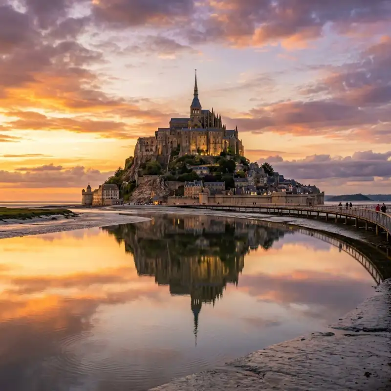
Bienvenue! Let us embark on an unforgettable #journey to the heart of #France. Mont-Saint-Michel (French pronunciation: [lə mɔ̃ sɛ̃ miʃɛl]; Norman: Mont Saint Miché; English: Saint Michael's Mount) is a tidal island and mainland commune in Normandy, #France. The island lies approximately one kilometre (half a nautical mile) off France's north-western coast, at the mouth of the Couesnon River near Avranches and is 7 hectares (17 acres) in area. The mainland part of the commune is 393 hectares (971 acres) in area so that the total surface of the commune is 400 hectares (990 acres). As of 2023, the island has a population of 23. The commune's position—on an island just a few hundred metres from land—made it accessible at low tide to the many pilgrims to its abbey, and defensible as the incoming tide stranded, drove off, or drowned threats on foot. The island remained unconquered during the Hundred Years' War. A small garrison fended off a full attack by the English in 1433. Louis XI recognised the benefits of its natural defence and turned it into a prison. The abbey was used regularly as a prison during the Ancien Régime. Mont-Saint-Michel and its surrounding bay were inscribed on the #UNESCO list of World Heritage Sites in 1979 for its unique aesthetic and importance as a Catholic site. It is visited by more than three million people each year, and is the most-visited tourist attraction in France outside of #Paris. Over 60 buildings within the commune are protected as historical monuments. Geography Formation Now a rocky tidal island, the mount occupied dry land in prehistoric times. As sea levels rose, erosion reshaped the coastal landscape, and several outcrops of granite emerged in the bay, having resisted the wear and tear of the ocean better than the surrounding rocks. These included Lillemer, Mont Dol, Tombelaine (the island just to the north), and Mont Tombe, later called Mont-Saint-Michel. Mont-Saint-Michel consists of leucogranite which solidified from an underground intrusion of molten magma about 525 million years ago, during the Cambrian period, as one of the younger parts of the Mancellian granitic batholith. Early studies of Mont-Saint-Michel by French geologists sometimes describe the leucogranite of the Mont as "granulite", but this granitic meaning of granulite is now obsolete. The mount has a circumference of about 960 m (3,150 ft) and its highest point is 92 m (302 ft) above sea level. Tides The tides vary greatly, at roughly 14 metres (46 ft) between highest and lowest water marks. Popularly nicknamed "St. Michael in peril of the sea" by medieval pilgrims making their way across the flats, the mount can still pose dangers for visitors who avoid the bridge and attempt the hazardous walk across the sands from the neighbouring coast. Polderisation and occasional flooding have created salt marsh meadows that were found to be ideally suited to grazing sheep. Agneau de pré-salé ('salt-meadow / salt-marsh lamb'), a local specialty that may be found on the menus of restaurants that depend on income from the many visitors to the mount. Tidal island The connection between Mont-Saint-Michel and the mainland has changed over the centuries. Previously connected by tidal causeway uncovered only at low tide, this was converted into a raised causeway in 1879, preventing the tide from scouring the silt around the mount. The coastal flats have been polderised to create pastureland, decreasing the distance between the shore and the island, and the Couesnon river has been canalised, reducing the dispersion of the flow of water. These factors have all encouraged silting-up of the bay. In June 2006, French prime minister Dominique de Villepin and regional authorities announced a €200 million project (Projet Mont-Saint-Michel) to build a hydraulic dam using the waters of the Couesnon and the tides to help remove the accumulated silt, and to make Mont-Saint-Michel an island again. The construction of the dam began in 2009. The project included the removal of the causeway and its visitor car park. Since April 2012, the new car park on the mainland has been located 2.5 kilometres (1+1⁄2 mi) from the island. Visitors can walk or use shuttles to cross the bridge. In July 2014, the new bridge, by architect Dietmar Feichtinger, was opened to the public. The light bridge allows waters to flow freely around the island and improves the efficiency of the now-operational dam. The bridge, which cost €209 million, was opened by President François Hollande. On rare occasions, tidal circumstances produce an extremely high "supertide". The new bridge was completely submerged on 21 March 2015 by the highest sea level, a once-in-18-years occurrence, as crowds gathered to snap photos. #history From the 8th century onward Before the construction of the first monastic establishment in the 8th century, the island was called Mont Tombe (Latin: tumba). According to a legend, the archangel Michael appeared in 708 to Aubert of Avranches, the bishop of Avranches, and instructed him to build a church on the rocky islet. Unable to defend his kingdom against the assaults of the Vikings, the king of the Franks agreed to grant the Cotentin Peninsula and the Avranchin, including Mont-Saint-Michel traditionally linked to the city of Avranches, to the Bretons in the Treaty of Compiègne. This marked the beginning of a brief period of Breton possession of the Mont. In fact, these lands and Mont-Saint-Michel were never really included in the duchy of Brittany. Around 989–990 these traditional bishoprics, dependent of the archbishopric of Rouen and that had been left vacant during the time of the Viking raids, regained their bishops. The mount gained strategic significance again in 933 when William I Longsword annexed the Cotentin Peninsula from the weakened Duchy of Brittany. This made the mount definitively part of Normandy, and is depicted in the Bayeux Tapestry, which commemorates the Norman Conquest. Harold Godwinson is pictured on the tapestry rescuing two Norman knights from the quicksand in the tidal flats during the Breton–Norman war. Norman ducal patronage financed the spectacular Norman #architecture of the abbey in subsequent centuries. In 1067, the monastery of Mont-Saint-Michel gave its support to William the Conqueror in his claim to the English throne. This he rewarded with properties and grounds on the English side of the Channel, including a small island off the southwestern coast of Cornwall which was modelled after Mont-Saint-Michel and became a Norman priory named St Michael's Mount of Penzance. Under the rule of the 29th abbot, Pierre le Roy, from 1386 to 1410, new fortifications were built: at the northeast corner of the Merveille, an octagonal crowning element was added to the Corbins tower; at its base, a long curtain wall-terrace overlooking the woods. In 1393, two turrets were added to flank the 1257 gate. Large steps were built in front of the barbican, and the abbot had a fortified residence built, as well as the square-based Pénine tower, designed to guard the Grand Degré. During the Hundred Years' War, English forces unsuccessfully besieged Mont-Saint-Michel (which was under French control) twice. The first siege started in 1423, and was lifted the next year. In 1433, an English force equipped with wrought-iron bombards and under the command of Thomas Scales, 7th Baron Scales again besieged the island. It was likewise lifted the next year. Scales's men abandoned two bombards they had used during the siege on 17 June 1434; they were recovered by the French and are currently on display. When Louis XI of France founded the Order of Saint Michael in 1469, he intended that the abbey church of Mont-Saint-Michel become the chapel for the order, but because of its great distance from Paris, his intention could never be realized. The wealth and influence of the abbey extended to many daughter foundations, including St Michael's Mount in Cornwall. Its popularity and prestige as a centre of pilgrimage waned with the Reformation, and by the time of the French Revolution there were scarcely any monks in residence. The abbey was closed and converted into a prison, initially to hold clerical opponents of the republican regime. High-profile political prisoners followed. By 1836, influential figures—including Victor Hugo—had launched a campaign to restore what was seen as a national architectural treasure. The prison was closed in 1863. In 1872, French architect of historic monuments Édouard Corroyer was responsible for assessing the condition of Mont-Saint-Michel. It took him about two years to convince his minister to classify it as a historic monument, and it was officially declared as such in 1874. From then on Corroyer, a member of the Academy of Fine Arts, devoted fifteen years of his life to the restoration of "la Merveille". Under his direction, gigantic works were undertaken, starting with the most urgent. He wrote four works on the building. During the occupation of France in World War II, German soldiers occupied Mont-Saint-Michel, where they used St. Aubert church as a lookout post. The island was a major attraction for German tourists and soldiers, with around 325,000 German tourists from July 18, 1940, to the end of the occupation of France. After the Allies' initial D-Day invasion of Normandy that began on June 6, 1944, many exhausted German soldiers retreated to strongholds like Mont-Saint-Michel. On August 1, 1944, a single American soldier – Private Freeman Brougher of Pennsylvania and the 72nd Publicity Service Battalion – reached and liberated Mont-Saint-Michel accompanied by two British reporters, Gault MacGowan of the New York Sun and Paul Holt with the London Daily Express. Jubilant crowds of locals greeted Brougher, Holt and MacGowan, and Brougher signed the Golden Book, the island's record of visiting nobility, at the mayor's invitation. The abbey was also used as a prison for the first time since the French Revolution when male collaborators with the Germans were jailed there. Mont-Saint-Michel and its bay were added to the UNESCO list of World Heritage Sites in 1979, listed with criteria such as cultural, historical, and architectural significance, as well as human-created and natural beauty. In June 2023, President Emmanuel Macron visited Mont-Saint-Michel to mark the 1,000-year anniversary of the abbey. He stated that the changes since the hydraulic dam and the new bridge opened have lessened the silting, making it an island again. Abbey design In the 11th century, William of Volpiano, the Italian architect who had built Fécamp Abbey in Normandy, was chosen by Richard II, Duke of Normandy, to be the building contractor. He designed the Romanesque church of the abbey, daringly placing the transept crossing at the top of the mount. Many underground crypts and chapels had to be built to compensate for this weight. These formed the basis for the supportive upward structure that can be seen today. Today Mont-Saint-Michel is seen as a building of Romanesque architecture. Robert de Thorigny, a great supporter of Henry II of England, who was also Duke of Normandy, reinforced the structure of the buildings and built the main façade of the church in the 12th century. In 1204, Guy of Thouars, regent for the Duchess of Brittany, as vassal of the King of France, undertook a siege of the Mount. After setting fire to the village and massacring the population, he beat a retreat under the powerful walls of the abbey. The fire which he lit extended to the buildings, and the roofs fell prey to the flames. Horrified by the cruelty of his Breton ally, Philip Augustus offered Abbot Jordan a grant for the reconstruction of the abbey in the new #gothic architectural style. Charles VI is credited with adding major fortifications to the abbey-mount, building towers, successive courtyards, and strengthening the ramparts. Development Administration The islet belongs to the French commune of Le Mont-Saint-Michel, in the département of Manche, in Normandy. The nearest significant town, with an SNCF train station, is Pontorson, with a population of slightly over 4,000. Mont-Saint-Michel belongs to the Organization of World Heritage Cities. Population The Monastic Fraternities of Jerusalem Since June 2001, following the appeal addressed to them in 2000 by Jacques Fihey, Bishop of Coutances and Avranches, a community of monks and nuns of the Monastic Fraternities of Jerusalem, sent from the mother-house of St-Gervais-et-St-Protais in Paris, have been living as a community on Mont-Saint-Michel. They replaced the Benedictine monks who returned to the mount in 1966. They are tenants of the centre for national monuments and are not involved in the management of the abbey. The community has seven sisters and four brothers. Their life revolves around prayer, work and fraternal life. The community meets four times a day to recite the liturgical office in the abbey, or in the crypt of Notre-Dame des Trente Cierges in winter. In 2012, the community undertook the renovation of a house on the mount, the Logis Saint-Abraham, which is used as a guest house for pilgrims on retreat. Dolphins in the bay In summer, dolphins from the warmer waters of the Atlantic Ocean follow the ocean currents to play around the local fishermen's traditional boats, the famous motorised barquettes. These small boats are about 5 metres long and 2 metres wide, typically with low-powered motors. The rotation of their propellers makes a smooth current attractive to the dolphins. Also, dolphins which have a very good memory know that the fishermen around the Mont-Saint-Michel are friendly to them and never harmful. Due to this, these dolphins approach the boats and play around them, offering a splendid spectacle. People and places of note Robert of Torigni, famous abbot of the mount; The Duke of Chartres (later Louis-Philippe I) came to demolish the "iron cage"; Louis Auguste Blanqui, political prisoner in the mount; Armand Barbès, political prisoner in the mount; La Mère Poulard, famous restaurant; Anne Boutiaut Poulard, creator of the Omelette de la mère Poulard. Tiphaine Raguenel, Breton noblewoman and astrologer. Economy The Mont-Saint-Michel has long been dominated by a handful of families which shared the businesses in the town and ran the village administration. Tourism is almost the sole source of income of the commune, bringing US$63 million to the small island in 2014. There are about 50 shops for three million tourists. The island is also home to four museums, showcasing the history, #culture, and heritage of Mont-Saint-Michel. About 25 people sleep every night on the mount, monks included, except for those in hotels. There are 132 hotel rooms within the island's walls. The main institutions are shared by: Eric Vannier, owner of the group Mère Poulard (holding half of restaurants, shops, hotels and three museums); Jean-Yves Vételé, CEO of Sodetour (five hotels, a supermarket and shops—all extramural—including Mercury Barracks); Patrick Gaul, former elected official, hotelier and intramural restaurateur; Independent merchants. Overtourism is a problem for Mont-Saint-Michel, exacerbated by tourists mostly visiting on day-trips, which causes overcrowding from 10:00 to 16:00, especially in the summer. The Mont-Saint-Michel foundation has introduced measures to change this pattern and reduce daytime overcrowding, including by introducing free parking after 18:30, except during July and August. The nearest airports to Mont-Saint-Michel are Rennes–Saint-Jacques Airport, located 88 km (55 mi) south and Nantes Atlantique Airport, located 198 km (123 mi) south. Twin towns and sister cities Hatsukaichi, Hiroshima, Japan, where Itsukushima Shrine, another UNESCO World Heritage Site, is located. Historically, Mont-Saint-Michel was the Norman counterpart of St Michael's Mount in Cornwall, England, which was given to the Benedictines, the religious order of Mont-Saint-Michel, by Edward the Confessor in the 11th century. The two mounts share the same tidal island characteristics and a similar conical shape, though Mont-Saint-Michel is much taller. Modern pilgrimage During the medieval period, pilgrims walked from Italy, Germany and England, as well as other parts of France. Such devotees were known as Miquelots. Modern pilgrims can follow the same routes. Ten hiking trails have been created that enable pilgrims from various European countries to retrace the path their ancestors may have taken during a medieval pilgrimage. In popular culture Cinema Part of the action in Helen MacInnes's 1943 film thriller Assignment in Brittany takes place at the Mont, including a dramatic nighttime chase across the sands. Alan Lee is said to have taken inspiration from Mont-Saint-Michel in designing Gondor's capital city, Minas Tirith, in Peter Jackson's 2003 film The Lord of the Rings: The Return of the King. The Kingdom of Corona in the 2010 Disney film Tangled is based on Mont-Saint-Michel. Monte-Saint-Michel was also featured in the final episode of the first season of The Walking Dead: Daryl Dixon as well as the second season. Mindwalk is a 1990 feature film directed by Bernt Capra, adapted from his short story based on The Turning Point, a nonfiction book by physicist Fritjof Capra, his brother. The movie was filmed on site at the Mont Saint-Michel and has views of (and scenes conceptually based around) many structures and features there, including the approach over the tidal flats, the #cathedral, the walkways, a torture chamber, and a giant, #ancient clock mechanism. Animation Mont-Saint-Michel makes a brief appearance in the 4th episode of the anime Saint Cecilia and Pastor Lawrence. Video games Mont-Saint-Michel is a World Wonder in Civilization VI. Mont-Saint-Michel is featured in Onimusha 3: Demon Siege in which the abbey is overrun by demons in both the 16th and 21st centuries and subsequently destroyed. A fictionalized version of the island, Beaumont-Saint-Denis, serves as the location for Sniper Elite 5's third mission. The castle is also the inspiration for the site of the climactic final battle in the air combat video game The Sky Crawlers: Innocent Aces, in which it is an abandoned enemy fortress with still-operational anti-air turrets. It also inspires the castle that appears on the cover art of the 1997 video game: Castlevania Symphony of the Night and Dark Souls' New Londo Ruins. Mont-Saint-Michel serves as an area in Country of the Musketeers in Kingdom Hearts: Dream Drop Distance, where Sora and the Three Musketeers composed of Mickey Mouse, Donald Duck and Goofy attempt to rescue Princess Minnie from Pete. The map "Corrode" introduced in June 2025 in Valorant takes inspiration from Mont-Saint-Michel. Music Mike Oldfield named a song after the island on his 1996 album Voyager. American musician Quadeca featured the island in the music video for his song "AT A TIME LIKE THIS". The song was included on his 2025 visual album Vanisher, Horizon Scraper. It appears in the 1992 music video Queen of Rain by Roxette. #france #travel #history #europe #culture Related InsightsBeyond the Horizon: Unveiling Naoshima and Teshima – Japan's Transformative Art Island Odyssey (Part 2) Калининград и Куршская коса Kölner Dom im Detail{ "@context": "https://schema.org", "@type": "FAQPage", "mainEntity": [ { "@type": "Question", "name": "What is the main focus of The Magic of Mont Saint-Michel: Normandy's Floating Abbey?", "acceptedAnswer": { "@type": "Answer", "text": "Join Camille Dubois on a journey exploring The Magic of Mont Saint-Michel and its incredible history." } }, { "@type": "Question", "name": "Who authored the comprehensive guide on The Magic of Mont Saint-Michel: Normandy's Floating Abbey?", "acceptedAnswer": { "@type": "Answer", "text": "This detailed article and its insights were carefully researched and authored by Camille Dubois." } }, { "@type": "Question", "name": "Where can I find more related content about Travel?", "acceptedAnswer": { "@type": "Answer", "text": "You can explore more articles, detailed reviews, and similar insights by browsing the Related Insights section at the bottom of this article or visiting our dedicated Travel category page." } } ] }