Showing Posts From
Travel
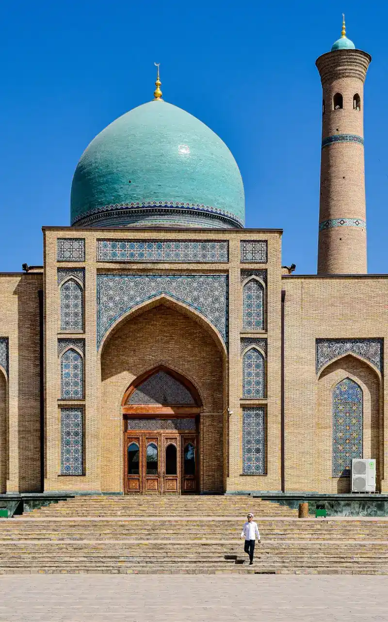
-
 John Explorer
 - 03 Jul, 2026 13:55
Beyond Samarkand's Shadow: Unearthing the Fergana Valley's Mystical Silk Road Legacies
The world, in its sprawling immensity, often presents us with dazzling facades: the Eiffel Tower, the Colosseum, the Great Wall. These titans of human endeavor draw millions, yet beneath their colossal shadows lie countless other narratives, whispered by wind-swept ruins and ancient paths, waiting for the curious few. What if the true essence of discovery isn't found on the well-worn map, but in the forgotten corners, where history breathes a different air and time flows with a quieter rhythm? As John Explorer, my compass has always pointed towards the whispers, not the roars, guiding me to destinations that challenge preconceptions and reward with unparalleled authenticity. My latest odyssey led me deep into Central Asia, not to the glittering mosaic-domed cities of Samarkand or Bukhara, but to a verdant, fertile crescent often overlooked: the Fergana Valley. Nestled between the Tien Shan and Alay mountain ranges, the Fergana Valley, shared by Uzbekistan, Kyrgyzstan, and Tajikistan, is a land of paradox. Historically, it was a pivotal artery of the Silk Road, renowned for its fabled "heavenly horses" that captivated Chinese emperors, its fertile soil yielding an abundance of fruits, and its strategic position connecting East and West. Yet, modern tourism largely bypasses it, drawn instead to the more iconic Uzbek cities further west. This oversight, however, is precisely its charm. To step into the Fergana Valley is to peel back layers of history, to encounter a living museum where ancient traditions, devout Sufi spirituality, and vibrant craftsmanship continue to thrive, largely untouched by the globalized gaze. It is a journey into the heart of a forgotten Silk Road branch, a place where the echoes of caravans still resonate, not in grand monuments, but in the soul of its people and the enduring rhythm of their lives. The Valley's Crucible of Civilizations: A Historical Overture My exploration began with a deep dive into the valley's storied past. For millennia, the Fergana Valley has been a melting pot of cultures. From the Sogdians and Persians to Turkic tribes and the conquering armies of Alexander the Great, Genghis Khan, and Timur, each left an indelible mark. It was the birthplace of Babur, founder of the Mughal Empire, and a powerful Khanate in its own right, particularly under Kokand. This rich tapestry of influences created a unique cultural synthesis, distinct from its western Uzbek counterparts, yet intrinsically linked to the broader Central Asian narrative. The valley's isolation, ringed by mountains, fostered a fierce independence and allowed certain cultural expressions to flourish, undisturbed for centuries. My initial days were spent traversing its undulating landscapes, envisioning the ancient riders on their famed horses, the Silk Road merchants bartering exotic goods, and the Sufi mystics seeking divine solace amidst the bustling markets. It’s this historical depth that provides the perfect backdrop for understanding the valley’s present-day allure. Whispers of the Divine: Tracing the Sufi Path One of the most profound aspects of the Fergana Valley is its deep-rooted Sufi heritage. While Sufism is prevalent throughout Central Asia, in Fergana, it feels particularly intimate and pervasive, woven into the fabric of daily life rather than confined to grand, tourist-centric complexes. My journey here was intentionally shaped by a desire to understand this spiritual dimension. The valley is home to countless mazars (shrines) and khanaqahs (Sufi lodges), many of them modest, tucked away in quiet courtyards or on hillsides, known primarily to local devotees. My most moving encounter was at a small, unassuming mazar dedicated to a revered local Sufi saint, somewhere between Kokand and Margilan. There were no tour buses, no souvenir stalls. Just a handful of local pilgrims, their faces etched with devotion, offering prayers and seeking blessings. The air was thick with incense and the murmur of whispered supplications. The elderly custodian, with eyes that held centuries of wisdom, invited me for a cup of tea, sharing tales of the saint's miracles and the enduring power of faith. He spoke of the importance of zikr (remembrance of God) and ishq (divine love), concepts that transcend language barriers and resonate with a universal quest for meaning. It was here, in this humble setting, that the true spirit of Fergana’s Sufism revealed itself – a gentle, inclusive, and deeply personal path to the divine.The city of Kokand, once the heart of a powerful khanate, also played a crucial role in Central Asian Sufism. Its magnificent Khudoyar Khan Palace, while a secular monument, stands as a testament to an era when spiritual leaders often held significant influence in court. Exploring its ornate chambers, I could almost hear the debates of scholars and Sufi masters who once graced its halls, shaping the intellectual and spiritual landscape of the region. The numerous smaller mosques and madrasahs scattered throughout Kokand further underscore its historical importance as a center of learning and spiritual contemplation, a testament to the enduring presence of faith. Echoes of the Steppe: Nomadic Legacies and Artisan Craft While the Fergana Valley is primarily an agricultural basin, the influence of its nomadic past and the trade routes that crisscrossed it are still palpable, particularly in its vibrant artisan traditions. This is a region where skills are passed down through generations, where the hands of craftsmen tell stories as old as the Silk Road itself. My journey took me to Rishtan, a town globally renowned for its unique blue ceramics. Here, the clay, rich in minerals from the local soil, combined with centuries-old techniques, transforms into breathtaking pieces of art. I spent hours in a bustling workshop, observing masters at work. The rhythmic whir of the potter's wheel, the meticulous application of natural glazes derived from plant ashes, and the patient firing process all culminate in the distinctive turquoise and cobalt hues that define Rishtan pottery. Each bowl, plate, and pitcher is not just a functional object but a canvas, often adorned with traditional patterns inspired by pomegranates, almond blossoms, and Islamic calligraphy. It’s a craft that requires immense patience, skill, and an understanding of the very earth beneath one's feet.Further east, in Margilan, I delved into the world of silk production. Margilan has been a silk-making hub for over two millennia, its history intertwined with the very fabric of the Silk Road. Here, traditional ikat weaving thrives, a complex resist-dyeing technique that creates mesmerizing patterns of shimmering colors. Walking through the Yodgorlik Silk Factory, one of the last remaining traditional workshops, was like stepping back in time. The rhythmic clack of the looms, the whirring of the spinning wheels, and the sight of vibrant silk threads being meticulously arranged into intricate designs offered a tangible connection to the ancient trade. The process, from silkworm cocoon to finished fabric, is labor-intensive and artistic, a testament to human ingenuity and dedication. Holding a piece of hand-woven Margilan silk is to touch a piece of history, to feel the legacy of the Silk Road against your fingertips. The bustling bazaars of every town, from Fergana City to Andijan, also serve as vibrant conduits to this past. Here, the nomadic spirit of trade and exchange is alive and well. Piles of freshly picked fruits, aromatic spices, hand-stitched suzani (embroidered textiles), and the ubiquitous chapans (traditional coats) create a riot of color and sound. These markets are not just places of commerce; they are social hubs, where stories are exchanged, friendships are forged, and the pulse of the community beats strongest. My conversations with vendors, often over cups of tea and shared smiles, offered invaluable insights into the daily lives and enduring traditions of the Fergana people. Culinary Journeys and the Warmth of Fergana Hospitality No journey through a foreign land is complete without immersing oneself in its culinary traditions, and Fergana offers a delightful array of tastes. The valley's fertile lands ensure an abundance of fresh produce, making its cuisine distinct and incredibly flavorful. Naturally, plov (rice pilaf) is king, but each region, each family, has its unique twist. I sampled numerous variations, each more delicious than the last, often cooked in colossal kazans (cauldrons) over open fires. The local laghman (hand-pulled noodles), hearty shashlik (kebabs), and various samsas (savory pastries) filled my days with warmth and flavor. Yet, beyond the food itself, it was the unparalleled hospitality of the Fergana people that left the deepest impression. Invited into homes for meals, sharing bread and conversation, I experienced a genuine warmth and generosity that transcended any language barrier. This is a culture where a guest is considered a gift from God, and every effort is made to ensure their comfort and happiness. These personal interactions, often spontaneous and heartfelt, were the true gems of my journey, transforming a mere trip into an enriching human experience. The Enduring Allure of the Uncharted Leaving the Fergana Valley, I carried not just souvenirs, but a profound sense of having touched something ancient and authentic. This region, often overlooked by the masses, holds a unique place in the tapestry of Central Asian history and culture. Its Sufi shrines offer a quiet spirituality, its artisans keep centuries-old traditions alive, and its people extend a hospitality that is truly legendary. For the intrepid traveler seeking more than just photo opportunities, the Fergana Valley offers an unparalleled opportunity to delve into a part of the world that still feels genuinely unexplored. It requires a willingness to step off the well-trodden path, to embrace the unexpected, and to listen to the whispers of history rather than the shouts of commercialism. In doing so, one discovers not just a forgotten branch of the Silk Road, but a vibrant, living culture that continues to flourish, quietly safeguarding its mystical legacies for those curious enough to seek them out. It is a reminder that the greatest treasures often lie hidden, waiting to be discovered by the truly adventurous heart.#Travel #FerganaValley #Uzbekistan #SilkRoad #SufiTraditions #CentralAsia Related InsightsCanyoning the Zambezi: Advanced Adventure Tactics for Remote River Explorations Sardegna Profonda: Sulle Tracce Misteriose dei Nuraghi nella Barbagia Nascosta Colmar and the Alsace Wine Route: A Colorful Escape{ "@context": "https://schema.org", "@type": "FAQPage", "mainEntity": [ { "@type": "Question", "name": "What is the main focus of Beyond Samarkand's Shadow: Unearthing the Fergana Valley's Mystical Silk Road Legacies?", "acceptedAnswer": { "@type": "Answer", "text": "Venture deep into Central Asia's Fergana Valley, a forgotten Silk Road branch brimming with ancient Sufi shrines, vibrant craftsmanship, and nomadic echoes. Discover a spiritual journey far from the well-trodden paths." } }, { "@type": "Question", "name": "Who authored the comprehensive guide on Beyond Samarkand's Shadow: Unearthing the Fergana Valley's Mystical Silk Road Legacies?", "acceptedAnswer": { "@type": "Answer", "text": "This detailed article and its insights were carefully researched and authored by John Explorer." } }, { "@type": "Question", "name": "Where can I find more related content about Travel?", "acceptedAnswer": { "@type": "Answer", "text": "You can explore more articles, detailed reviews, and similar insights by browsing the Related Insights section at the bottom of this article or visiting our dedicated Travel category page." } } ] }
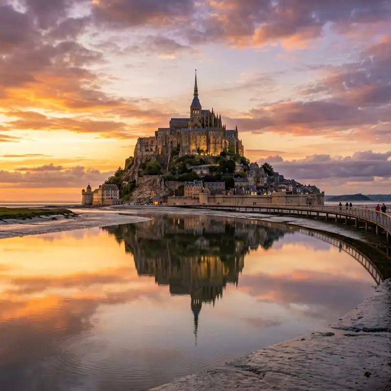
Bem-vindo! Prepare-se para uma #viagem inesquecível pelo coração de #Portugal. Olá, amantes de viagens e descobridoras de mundos! Sou o vosso Tiago Silva, e hoje levo-vos numa jornada inesquecível a uma cidade que mora no meu coração e na alma de #Portugal. Preparem-se para se perderem nas ruas calcetadas, nos aromas do passado e nos sons de um presente vibrante, porque vamos explorar Lisboa: A Cidade das Sete Colinas. Lisboa: O Abraço Atlântico e a Porta da Europa Imaginem uma cidade que se debruça sobre o oceano, onde o sol beija as águas de um rio majestoso e onde a brisa do Atlântico sussurra histórias de navegadores e descobertas. Essa é Lisboa, a capital e a maior cidade do nosso querido Portugal, um epicentro de vida e cultura que pulsa com uma energia inconfundível. Com uma população que, em 2022, se estimava em cerca de 548.703 habitantes nos seus cem quilómetros quadrados de encantos, Lisboa não é apenas um número, mas um universo de experiências à espera de ser desvendado. É aqui, neste cantinho abençoado da Península Ibérica, que encontramos a capital mais ocidental da Europa continental. Sim, ouviram bem! Enquanto outras capitais europeias se aninham mais a leste, ou se escondem em ilhas distantes como Reiquiavique e Dublin, Lisboa ergue-se orgulhosamente ao longo da costa atlântica, a única capital continental a desfrutar deste privilégio. É uma posição geográfica que moldou a sua identidade, a sua luz e a sua alma. A cidade estende-se graciosamente na margem norte do rio Tejo, um espelho de água que reflete séculos de história e que serve de cenário para alguns dos mais belos pores-do-sol que já tive o prazer de testemunhar. E se falarmos de extremos, a área metropolitana de Lisboa guarda um segredo ainda mais ocidental: o imponente Cabo da Roca, na deslumbrante Costa do Estoril. É o ponto mais ocidental da Europa continental, um lugar onde a terra acaba e o mar começa, e onde a vastidão do oceano nos lembra a audácia dos nossos antepassados. Esta região metropolitana é um verdadeiro caldeirão de vida, acolhendo cerca de 3 milhões de pessoas, o que a torna a terceira maior área metropolitana da Península Ibérica, apenas superada por Madrid e Barcelona. É uma das dez áreas urbanas mais populosas da União Europeia, e representa cerca de um terço da população total do país. Um facto que, por si só, demonstra a centralidade e a importância desta cidade no panorama nacional e europeu. Cada vez que regresso a Lisboa, sinto que estou a regressar a casa, a um lugar onde a história se encontra com a modernidade num abraço perfeito. É uma sensação que só uma grande #viagem pode proporcionar. Um Palimpsesto de Milénios: A História Viva de Lisboa Caminhar por Lisboa é como folhear um livro de história vivo, onde cada rua, cada praça, cada pedra tem uma história para contar. É uma das cidades mais antigas do mundo e, preparem-se para este dado fascinante, a segunda capital europeia mais antiga, superada apenas por Atenas. Sim, Lisboa antecede em séculos muitas das capitais europeias modernas que hoje conhecemos e admiramos. É uma antiguidade que se sente no ar, que se respira nas suas vielas e que se vê nos seus monumentos. A sua fundação remonta a tempos imemoriais, quando tribos pré-celtas já habitavam estas terras férteis. Mais tarde, os fenícios, mestres do comércio marítimo, estabeleceram aqui um porto vibrante, aproveitando a localização estratégica do estuário do Tejo. Imagino os seus navios a aportar, carregados de mercadorias exóticas, dando início à vocação cosmopolita de Lisboa. A influência romana não tardou a chegar, e foi Júlio César quem elevou a cidade ao estatuto de município romano, batizando-a de Felicitas Julia, um termo que se acrescentou ao nome original, Olissipo. A era romana deixou marcas indeléveis, desde os vestígios arqueológicos até à própria organização da cidade. Com a queda do Império Romano, Lisboa passou por um período de transições, sendo governada por uma sucessão de tribos germânicas a partir do século V, com os Visigodos a deixarem a sua pegada mais notável. No entanto, o século VIII trouxe uma nova onda de transformação com a invasão moura. Durante séculos, a cidade floresceu sob o domínio islâmico, enriquecendo-se com novos conhecimentos, arquiteturas e culturas. A Lisboa moura era um centro de saber e beleza, e ainda hoje podemos vislumbrar essa influência em certos bairros e na toponímia. Foi em 1147 que um capítulo decisivo foi escrito na longa #história de Lisboa. Afonso Henriques, o primeiro rei de Portugal, empreendeu a reconquista da cidade, um evento que marcou profundamente a identidade nacional. E em 1255, a coroação da sua importância: Lisboa tornou-se oficialmente a capital do Reino de Portugal, substituindo Coimbra. Desde então, nunca mais perdeu esse estatuto, firmando-se como o coração pulsante do país. O Coração Pulsante de Portugal: Um Centro de Poder e Cultura Desde aquele ano de 1255, Lisboa tem sido, ininterruptamente, o centro nevrálgico de Portugal em todas as frentes. É aqui que o pulso político do país bate mais forte, sendo a sede do governo, da Assembleia da República, onde as leis são debatidas e criadas, e do Supremo Tribunal de Justiça, guardião da legalidade. As Forças Armadas têm na capital o seu comando central, e é também aqui que reside o nosso chefe de Estado, o Presidente da República, num palácio que observa o Tejo. Mas Lisboa não é apenas o centro da governação interna; é também o epicentro da diplomacia portuguesa no mundo. A cidade acolhe embaixadores de 86 países, cada um representando a sua nação e fortalecendo os laços internacionais de Portugal. Além disso, representações de Taiwan e da Palestina também têm aqui a sua voz, sublinhando o papel de Lisboa como um ponto de encontro global. Esta efervescência diplomática confere à cidade um ambiente verdadeiramente internacional, onde diferentes culturas se cruzam e se influenciam mutuamente. É uma prova da abertura e da relevância de Portugal no cenário mundial. A riqueza da #cultura lisboeta é inegável, manifestando-se em cada esquina, em cada fachada de azulejos, no fado que ecoa pelas noites de Alfama, ou nos museus que guardam tesouros de milénios. Esta cidade é um palco onde o passado se encontra com o presente, onde as tradições se misturam com as tendências mais modernas, criando uma atmosfera única e apaixonante. Uma Metrópole Global de Destaque: Brilho e Inovação Lisboa transcendeu há muito tempo o seu papel de capital nacional para se afirmar como uma verdadeira cidade global, reconhecida com o estatuto de nível alfa. Este reconhecimento não é por acaso, mas sim um reflexo da sua crescente importância em áreas tão diversas como as finanças, o comércio, a moda, a mídia, o entretenimento, as artes, o comércio internacional, a educação e o turismo. Lisboa não é apenas um destino, é um motor de inovação e um centro de oportunidades. É uma das duas cidades portuguesas (sendo a outra o Porto, a minha cidade natal!) a ostentar este título de cidade global, o que demonstra a vitalidade económica e cultural do nosso país. A capital é, inclusive, a sede de três empresas que figuram na prestigiada lista Global 2000: o Grupo EDP, a Galp Energia e a Jerónimo Martins. Estes gigantes empresariais são um testemunho da força e da capacidade de Lisboa em gerar valor e inovação à escala mundial. A cidade é, sem dúvida, um dos grandes centros económicos da #Europa. O seu setor financeiro está em constante crescimento, com o índice PSI a integrar a Euronext, a maior bolsa de valores da Europa continental. Este é um indicador claro da confiança dos investidores e da solidez económica da região. A riqueza gerada em Lisboa é notável, com a região a apresentar um PIB por paridade do poder de compra per capita mais elevado do que qualquer outra região portuguesa. É um polo de prosperidade que atrai talento e investimento. Não é de estranhar, portanto, que Lisboa ocupe o 40º lugar no ranking mundial de maior rendimento bruto. A cidade é também um refúgio para a riqueza, com quase 21 mil milionários residentes, o que a coloca como a 11ª cidade europeia em número de milionários e a 14ª em número de bilionários. Estes números, embora frios, pintam um quadro de uma metrópole dinâmica e próspera. A maior parte das sedes das empresas multinacionais portuguesas estão estrategicamente localizadas na região de Lisboa, reforçando o seu papel como centro de decisão e inovação. É uma cidade que, apesar da sua antiguidade, está sempre a olhar para o futuro, a construir e a reinventar-se. O Enigma do Nome: Olissipo, Ulisses e Além A história de um lugar é inseparável da história do seu nome, e a etimologia de Lisboa é um mistério fascinante, com várias origens sugeridas, mas nenhuma conclusiva. É como tentar desvendar um segredo antigo, sussurrado pelos ventos que sopram do Tejo. Uma das versões mais recentes e credíveis, sugerida por Francisco Villar, aponta para que "Olissipo" possa ter origem na extinta língua tartessa, falada pelos povos Tartessos que habitaram algumas áreas no sul do país. É intrigante pensar que o prefixo "Oli(s)" não seria único, visto estar associado a outra cidade lusitana de localização desconhecida, que Pompónio Mela referia como "Olitingi". Isto sugere uma possível raiz linguística comum, um eco de civilizações perdidas. No século XVII, Samuel Bochart, um académico francês dedicado ao estudo da Bíblia, propôs que Olissipo seria uma designação pré-romana, remontando aos fenícios, que no seu tempo comercializavam intensamente na Península Ibérica. Segundo ele, Olissipo seria uma derivação do fenício "Allis Ubbo", que significaria "Porto Seguro", uma alusão mais que apropriada ao excelente porto natural situado no estuário do Tejo. Embora esta teoria seja poeticamente apelativa, a ausência de registos que a comprovem levou os académicos recentes a descartá-la. Contudo, a imagem de um "Porto Seguro" ressoa com a natureza acolhedora e protetora de Lisboa, um farol na #natureza atlântica. Os autores da Antiguidade, por sua vez, preferiam uma lenda mais épica, atribuindo a fundação de Olissipo ao próprio Ulisses, o astuto herói da mitologia grega. Baseando-se provavelmente em Estrabão, contava-se que Ulisses teria fundado uma cidade chamada Olissipo num local incerto da Península Ibérica, supostamente nas margens do rio Tejo. Esta lenda, embora mítica, confere a Lisboa um toque de grandiosidade e heroísmo que se encaixa perfeitamente na sua história. Posteriormente, durante a época Romana, o nome adaptou-se para a versão latina Olissipona ou Ulyssipona. Ptolomeu, outro geógrafo da antiguidade, chamou-lhe Oliosipon. Com a chegada dos Suevos e Visigodos, a interpretação germânica da língua transformou-a em Ulishbon. E, como já mencionei, #portugal #travel #history #europe #cultura Related InsightsLe Cattedrali Sotterranee di Puglia: Un Viaggio Intimo nelle Città Rupestri delle Gravine The Dark Heart of Paris: Exploring the Catacombs Le Isole che Respirano il Vento: Il Risveglio Silenzioso delle Fær Øer{ "@context": "https://schema.org", "@type": "FAQPage", "mainEntity": [ { "@type": "Question", "name": "What is the main focus of Lisboa: A Cidade das Sete Colinas?", "acceptedAnswer": { "@type": "Answer", "text": "Junte-se a Tiago Silva numa exploração profunda por Lisboa." } }, { "@type": "Question", "name": "Who authored the comprehensive guide on Lisboa: A Cidade das Sete Colinas?", "acceptedAnswer": { "@type": "Answer", "text": "This detailed article and its insights were carefully researched and authored by Tiago Silva." } }, { "@type": "Question", "name": "Where can I find more related content about Travel?", "acceptedAnswer": { "@type": "Answer", "text": "You can explore more articles, detailed reviews, and similar insights by browsing the Related Insights section at the bottom of this article or visiting our dedicated Travel category page." } } ] }
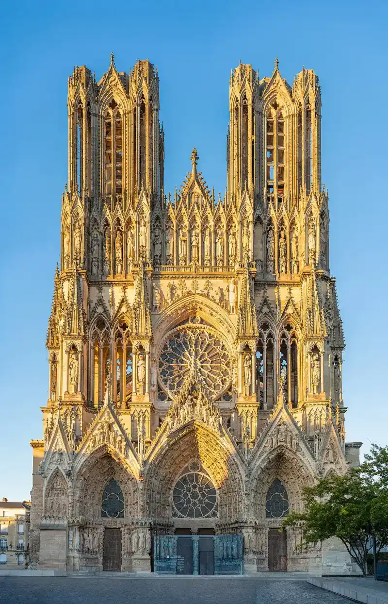
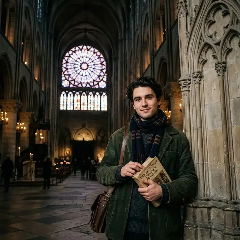
La Cathédrale de Reims : Le Sanctuaire des Rois de #France Bonjour à tous, passionnés d'histoire ! Je suis Lucas Martin. Pour clore ce tour d'horizon des grandes structures gothiques d'Europe, nous revenons en France, dans la région de la Champagne. Si Notre-Dame de #Paris est la cathédrale de la capitale, et Chartres la cathédrale de la lumière, Notre-Dame de Reims est la cathédrale de la Nation. Elle est le lieu sacré par excellence de la monarchie française. La Cité des Sacres Pendant près de 1 000 ans, la quasi-totalité des rois de France ont été couronnés dans cette cathédrale (33 souverains au total !). Pourquoi Reims ? L'histoire remonte à l'an 496, lorsque Clovis, le premier roi des Francs, y fut baptisé par l'évêque Saint-Remi. La légende raconte qu'une colombe descendue du ciel aurait apporté la "Sainte Ampoule", une fiole contenant une huile divine utilisée pour oindre les futurs rois. Reims est donc devenue le lieu de légitimation du pouvoir royal absolu. L'événement historique le plus célèbre s'y est déroulé le 17 juillet 1429 : le sacre de Charles VII, rendu possible par l'héroïsme de Jeanne d'Arc, présente dans la nef avec son étendard. Le Chef-d'œuvre du Gothique Flamboyant D'un point de vue architectural, Reims est souvent considérée (avec Amiens) comme l'apogée du style gothique rayonnant. Construite rapidement au 13e siècle (comme Chartres), la cathédrale de Reims pousse la recherche de hauteur et d'ouverture des murs encore plus loin. Sa façade ouest est une véritable dentelle de pierre. Là où les autres cathédrales conservent des tympans en pierre pleine au-dessus des portes, les bâtisseurs de Reims ont innové en y plaçant d'immenses rosaces en vitrail. C'est ce qu'on appelle "le triomphe de la lumière sur la matière". Avec plus de 2 300 statues qui ornent ses murs extérieurs, c'est l'édifice religieux gothique le plus sculpté au monde. L'Ange au Sourire : Le Symbole de la Ville Parmi ces milliers de sculptures, une figure se détache et a capté le cœur du monde entier : le fameux "Ange au Sourire" (L'Ange Gabriel), situé sur le portail nord de la façade ouest. Sculpté au milieu du 13e siècle, cet ange possède une expression d'une douceur et d'un humanisme frappants, très éloignée de la rigidité des sculptures romanes antérieures. Il illustre le nouveau courant artistique du gothique qui cherchait à doter les figures saintes d'émotions humaines. La Cathédrale Martyre (1914-1918) Malheureusement, l'histoire de Reims est tragiquement marquée par la Première Guerre Mondiale. Située près de la ligne de front, la cathédrale a été bombardée sans pitié par l'artillerie allemande en septembre 1914. Les échafaudages en bois qui entouraient la tour nord prirent feu, la toiture en plomb fondit, et la façade fut terriblement endommagée. L'"Ange au Sourire" a d'ailleurs eu la tête décapitée (elle sera restaurée plus tard). Ces bombardements suscitèrent une indignation mondiale. La cathédrale en ruine devint le symbole du patrimoine culturel européen détruit par la folie de la guerre (surnommée la "cathédrale martyre"). Grâce au financement d'importants mécènes américains (notamment la fondation Rockefeller), l'édifice fut patiemment reconstruit et restauré au lendemain de la guerre. Sa nouvelle charpente n'est plus en chêne, mais en béton armé (innovation majeure de l'architecte Henri Deneux). Une Renaissance par le Vitrail Les bombardements ont brisé la plupart des vitraux médiévaux de la nef. Pour combler les lacunes lumineuses, la cathédrale a fait appel, à la fin du 20e siècle, aux plus grands artistes contemporains. Le chef-d'œuvre incontesté de cette commande moderne se trouve dans la chapelle d'axe : trois magnifiques verrières créées en 1974 par le maître de la couleur, Marc Chagall. L'utilisation de ses bleus profonds, de ses rouges et de son iconographie onirique se marie avec une grâce absolue au chœur gothique. Récemment, en 2011, l'artiste allemand Imi Knoebel a également ajouté des vitraux géométriques et très colorés. Reims est donc le pont parfait entre le génie médiéval et l'art contemporain. En Conclusion Visiter Reims, c'est comprendre l'essence du pouvoir en France. C'est aussi admirer un bâtiment qui, bien qu'ayant frôlé l'annihilation, se dresse toujours, fier et magnifique, rappelant que la #culture et la beauté triomphent toujours de la destruction. Ne manquez surtout pas de déguster une flûte de Champagne (la région y oblige !) en admirant cette dentelle de pierre au soleil couchant. #Reims #France #RoisDeFrance #Gothique #PremiereGuerreMondiale #Chagall #AngeAuSourire Related InsightsDie Flüsternden Kristalle Siziliens: Eine Entdeckungsreise entlang der vergessenen Salzstraßen The Obsidian Trails: Tracing Azerbaijan's Forgotten Fire Keepers of Garasu The City of the Gods: Documenting Teotihuacan{ "@context": "https://schema.org", "@type": "FAQPage", "mainEntity": [ { "@type": "Question", "name": "What is the main focus of La Cathédrale de Reims : Le Sanctuaire des Rois de France?", "acceptedAnswer": { "@type": "Answer", "text": "Plongez dans l'histoire de la cathédrale Notre-Dame de Reims, le joyau meurtri du gothique champenois, lieu mythique des sacres des rois de France." } }, { "@type": "Question", "name": "Who authored the comprehensive guide on La Cathédrale de Reims : Le Sanctuaire des Rois de France?", "acceptedAnswer": { "@type": "Answer", "text": "This detailed article and its insights were carefully researched and authored by Lucas Martin." } }, { "@type": "Question", "name": "Where can I find more related content about Travel?", "acceptedAnswer": { "@type": "Answer", "text": "You can explore more articles, detailed reviews, and similar insights by browsing the Related Insights section at the bottom of this article or visiting our dedicated Travel category page." } } ] }
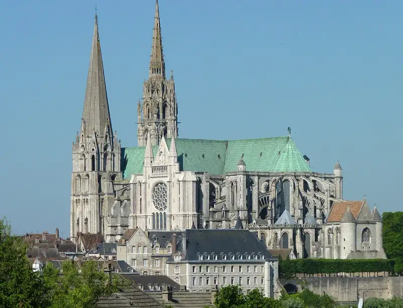
La Cathédrale de Chartres : Les Mystères de ses Vitraux Bonjour à tous, ici Lucas. S'il ne devait rester qu'un seul édifice pour représenter l'apogée de l'#architecture médiévale, le summum de l'harmonie religieuse et du savoir-faire humain, beaucoup d'historiens de l'art choisiraient celui dont nous allons parler aujourd'hui. Située à 80 kilomètres au sud-ouest de #Paris, émergeant majestueusement des vastes plaines céréalières de la Beauce, voici Notre-Dame de Chartres. Un Monument Préservé par Miracle Contrairement à Notre-Dame de Paris ou à Reims, la cathédrale de Chartres n'a pratiquement pas été endommagée par les guerres, la Révolution française ou les incendies ultérieurs. Ce que nous voyons aujourd'hui est l'édifice tel qu'il a été achevé au début du 13e siècle. C'est l'un des monuments les plus authentiques de la planète. L'histoire de la construction de Chartres est fascinante. En 1194, un incendie terrible ravage l'ancienne cathédrale romane. La population est au désespoir, pensant que la relique la plus sacrée de la ville, la Sancta Camisia (le voile ou la tunique que la Vierge Marie aurait porté lors de la naissance du Christ), a été détruite. Mais trois jours plus tard, miracle : les prêtres émergent de la crypte, saufs, portant la précieuse relique indemne ! Cet "intervention divine" provoque un immense élan de foi et de dons dans toute l'Europe (y compris de la part du roi Richard Cœur de Lion). Grâce à cette richesse soudaine, la cathédrale actuelle a été construite en un temps record d'environ 30 ans ! Cette rapidité explique la cohérence et l'harmonie exceptionnelles de son style : c'est le modèle parfait du gothique "classique". Le Bleu de Chartres : Le Mystère des Maîtres Verriers La gloire absolue de Chartres, ce qui attire les chercheurs du monde entier, ce sont ses vitraux. La cathédrale possède la collection de vitraux des 12e et 13e siècles la plus vaste et la mieux conservée au monde (176 verrières, représentant plus de 2 600 mètres carrés de verre !). Le secret le plus célèbre réside dans une couleur spécifique : le fameux "Bleu de Chartres" (présent notamment dans le célèbre vitrail de "Notre-Dame de la Belle Verrière"). C'est un bleu cobalt d'une intensité et d'une luminosité stupéfiantes. Le secret exact de la composition chimique de ce verre bleuté a été perdu au Moyen Âge, et même avec les technologies modernes, les maîtres verriers ont du mal à reproduire cette nuance exacte qui capte la lumière comme un saphir liquide. La Sculpture : Un Livre de Pierre Chartres possède trois grands portails sculptés qui sont des chefs-d'œuvre de l'évolution de la sculpture médiévale :Le Portail Royal (Ouest) : Survivant de l'incendie de 1194, il date de 1150. Les figures bibliques allongées en colonnes sont raides, figées, le regard tourné vers l'éternité (style roman tardif). Les Portails Nord et Sud : Réalisés au 13e siècle, ils montrent une véritable révolution artistique. Les statues se détachent du mur, prennent vie, pivotent sur leurs hanches, sourient ou discutent entre elles. C'est l'éveil du naturalisme gothique, préfigurant la Renaissance.Le Labyrinthe : Le Chemin de Jérusalem Un autre mystère au cœur de la nef : le labyrinthe. Dessiné sur le dallage en pierres noires et blanches au 13e siècle, il mesure près de 13 mètres de diamètre. Sa longueur totale, du début jusqu'au centre, est de 261,5 mètres. Au Moyen Âge, il était utilisé par les fidèles (qui le parcouraient souvent à genoux) comme un substitut au pèlerinage à Jérusalem, qui était long et dangereux. Le centre représentait la Jérusalem céleste, le salut. Fait fascinant : le diamètre du labyrinthe est exactement de la même taille que la grande rosace ouest. S'il était possible de replier la façade sur le sol, la rosace viendrait se superposer parfaitement sur le labyrinthe. Un témoignage troublant de la géométrie sacrée utilisée par les bâtisseurs. Mon Avis d'Historien Si vous êtes de passage à Paris, prenez ce train de 50 minutes vers Chartres. L'expérience de la lumière filtrant à travers les vitraux centenaires, plongeant la nef dans une lueur bleutée et pourpre, est l'une des expériences esthétiques les plus bouleversantes que l'on puisse vivre en Europe. Chartres n'est pas seulement un bâtiment d'ingénierie révolutionnaire, c'est un poème mystique écrit dans la pierre et la lumière. #Chartres #France #Vitraux #GothiqueClassique #MoyenAge #BleuDeChartres #Patrimoine Related InsightsEl Generalife: Los Jardines del Paraíso The Faroe Islands: Where Nordic Wilderness Meets Photographic Magic La Expansión del Islam y los Primeros Musulmanes{ "@context": "https://schema.org", "@type": "FAQPage", "mainEntity": [ { "@type": "Question", "name": "What is the main focus of La Cathédrale de Chartres : Les Mystères de ses Vitraux?", "acceptedAnswer": { "@type": "Answer", "text": "Découvrez la cathédrale Notre-Dame de Chartres en France, le chef-d'œuvre absolu du gothique, célèbre pour son labyrinthe, le voile de la Vierge et ses vitraux mystiques." } }, { "@type": "Question", "name": "Who authored the comprehensive guide on La Cathédrale de Chartres : Les Mystères de ses Vitraux?", "acceptedAnswer": { "@type": "Answer", "text": "This detailed article and its insights were carefully researched and authored by Lucas Martin." } }, { "@type": "Question", "name": "Where can I find more related content about Travel?", "acceptedAnswer": { "@type": "Answer", "text": "You can explore more articles, detailed reviews, and similar insights by browsing the Related Insights section at the bottom of this article or visiting our dedicated Travel category page." } } ] }
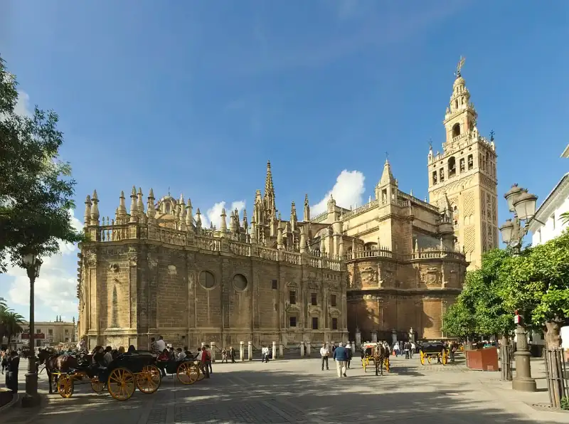
La Cathédrale de Séville : Gothique et Héritage Andalou Salutations aux amoureux du voyage et du patrimoine ! Ici Lucas Martin. Descendons aujourd'hui dans le sud chaud et ensoleillé de l'Espagne, en Andalousie. Nous allons visiter la Catedral de Santa María de la Sede à Séville. Pourquoi ce choix ? Parce qu'en termes de volume, c'est tout simplement la plus grande cathédrale gothique du monde. "Construisons une Église si Belle et si Grande..." L'histoire de la cathédrale de Séville est profondément liée à la Reconquista espagnole. En 1248, le roi chrétien Ferdinand III conquiert Séville, alors sous domination maure (musulmane) depuis plus de 500 ans. Au lieu de détruire la gigantesque mosquée almohade de la ville, les Chrétiens la consacrent et l'utilisent comme cathédrale. Cependant, en 1401, l'édifice est gravement endommagé par un tremblement de terre. Le chapitre de la cathédrale prend alors une décision radicale. La légende raconte qu'ils auraient déclaré : "Construisons une église si belle et si grande que ceux qui la verront achevée nous prendront pour des fous". Une Empreinte Musulmane Indélébile Pour construire cet édifice titanesque, les architectes durent raser la mosquée. Mais ils conservèrent deux éléments majeurs, qui font aujourd'hui toute l'originalité du monument :Le Patio de los Naranjos (La cour des orangers) : L'ancienne cour des ablutions de la mosquée, avec sa fontaine centrale et ses orangers odorants, offre aujourd'hui un sas de paix et de fraîcheur avant d'entrer dans la cathédrale chrétienne. La Giralda : C'est le minaret original de la mosquée du 12e siècle. Au lieu de le détruire, les Chrétiens l'ont surmonté d'un beffroi abritant les cloches. Haute de 104 mètres, elle reste le symbole absolu de Séville. Sa particularité ? À l'intérieur, il n'y a pas d'escaliers, mais 35 rampes inclinées assez larges pour que le muezzin puisse monter à cheval pour l'appel à la prière !Un Intérieur Titanesque L'intérieur de la cathédrale est conçu sur le plan rectangulaire (très rare dans le gothique) hérité de l'ancienne mosquée. Il compte cinq nefs d'une ampleur étourdissante. L'élément central et le plus impressionnant est le Retablo Mayor (le grand retable) situé dans la chapelle principale. C'est tout simplement le plus grand retable de la chrétienté. Sculpté en bois de noyer, de châtaignier et de mélèze pendant plus de 80 ans, il raconte 45 scènes de la vie du Christ et de la Vierge. Il est entièrement recouvert d'or provenant des toutes nouvelles colonies espagnoles d'Amérique. Ce mur d'or qui scintille dans la pénombre est d'une beauté saisissante. Le Tombeau d'un Explorateur Controversé La cathédrale de Séville attire des millions de curieux pour une autre raison majeure : elle abrite le majestueux monument funéraire de Christophe Colomb. Le tombeau est impressionnant. Le cercueil du navigateur n'est pas posé sur le sol, mais porté sur les épaules par quatre immenses statues allégoriques représentant les quatre royaumes d'Espagne : Castille, León, Aragon et Navarre. (Fait amusant : les statues de Castille et León, qui ont soutenu financièrement Colomb, ont la tête haute, tandis qu'Aragon et Navarre, qui ont été plus réticents, regardent vers le bas). Pendant des décennies, une controverse a fait rage avec la République dominicaine, qui affirmait posséder les véritables restes de Colomb. Des tests ADN récents ont confirmé à 100% que les os à Séville sont bien ceux du célèbre explorateur. Le Mélange des Cultures : Le Style Mudéjar La cathédrale de Séville, et plus largement l'#architecture andalouse, est le parfait exemple du style mudéjar. C'est un style architectural produit par les artisans musulmans restés en territoire chrétien après la Reconquista, mêlant les structures gothiques (et plus tard de la Renaissance) avec l'ornementation islamique (entrelacs géométriques, stucs, céramiques). En vous promenant autour de l'édifice, vous remarquerez comment les voûtes à nervures gothiques cohabitent avec l'arc en fer à cheval almohade. La cathédrale de Séville est bien plus qu'une prouesse technique ; c'est un palimpseste architectural, un livre de pierre où se lit le choc et la fusion des grandes civilisations de la Méditerranée. Un conseil : Montez au sommet de la Giralda en fin d'après-midi. La lumière dorée d'Andalousie qui se reflète sur les toits blancs de Séville est un spectacle que vous n'oublierez jamais. #Séville #Andalousie #Giralda #Gothique #ChristopheColomb #HistoireDEspagne #UNESCO #Espagne #Andalousie #Sville #Gothique Related InsightsThe Faroe Islands: Where Nordic Wilderness Meets Photographic Magic Die steinerne Ewigkeit von Stonehenge: Ein Echo aus prähistorischen Nebeln, das bis heute verweilt Das Ewige Gewitter vom Maracaibo: Eine Reise ins Haus des Donners{ "@context": "https://schema.org", "@type": "FAQPage", "mainEntity": [ { "@type": "Question", "name": "What is the main focus of La Cathédrale de Séville : Gothique et Héritage Andalou?", "acceptedAnswer": { "@type": "Answer", "text": "Explorez la majestueuse Cathédrale de Séville en Andalousie, construite sur les restes d'une mosquée, abritant le tombeau de Christophe Colomb et la célèbre Giralda." } }, { "@type": "Question", "name": "Who authored the comprehensive guide on La Cathédrale de Séville : Gothique et Héritage Andalou?", "acceptedAnswer": { "@type": "Answer", "text": "This detailed article and its insights were carefully researched and authored by Lucas Martin." } }, { "@type": "Question", "name": "Where can I find more related content about Travel?", "acceptedAnswer": { "@type": "Answer", "text": "You can explore more articles, detailed reviews, and similar insights by browsing the Related Insights section at the bottom of this article or visiting our dedicated Travel category page." } } ] }
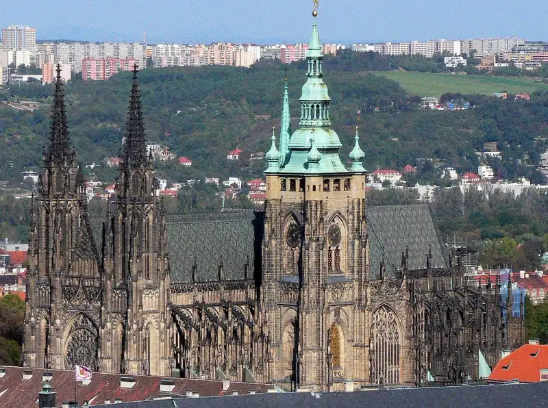
La Cathédrale Saint-Guy de Prague : Joyau de Bohême Bonjour les voyageurs du temps, ici Lucas Martin. Lorsque l'on évoque les grandes cathédrales d'Europe, on a tendance à se concentrer sur la #France, l'Angleterre ou l'Allemagne. Pourtant, au cœur de l'Europe centrale, perchée sur une colline dominant la Vltava, se trouve un monument qui n'a absolument rien à envier à Notre-Dame de #Paris : la Cathédrale Saint-Guy (Katedrála svatého Víta) à Prague. Le Cœur du Château La position de Saint-Guy est unique. Elle n'est pas construite sur une place au milieu de la ville, mais à l'intérieur même des murs du Château de Prague (le plus grand complexe castral ancien au monde). C'était le symbole ultime de la fusion entre le pouvoir spirituel et le pouvoir impérial royal. Fondée en 1344 par le roi de Bohême (et futur empereur du Saint-Empire) Charles IV, la cathédrale devait être la nécropole de la dynastie des Přemyslides et le lieu du trésor national. L'architecte initial était un Français, Mathieu d'Arras, ce qui explique le plan de base très inspiré des cathédrales du sud de la France (comme Narbonne). Mais c'est à la mort de Mathieu que la cathédrale va acquérir son caractère unique. Le Génie de Peter Parler En 1356, Charles IV confie le chantier à un jeune architecte souabe de 23 ans : Peter Parler. Ce que Parler va accomplir à Prague va révolutionner le style gothique. Là où le gothique français privilégiait la linéarité et la répétition géométrique stricte, Parler introduit une liberté et une dynamique inouïes. Son invention majeure est la voûte réticulée (net vault). Les nervures du plafond ne se croisent plus simplement en forme de "X", mais forment des motifs complexes en réseau (des étoiles, des losanges) qui donnent une impression de fluidité et de continuité, gommant la séparation entre les travées. Dans le triforium (la galerie de circulation à l'étage), Parler a sculpté des dizaines de bustes représentant la famille royale, l'archevêque, mais aussi les architectes (dont lui-même !). C'est l'une des premières fois au Moyen Âge que l'architecte se représente lui-même, marquant l'émergence de la notion d'artiste individuel. La Chapelle Saint-Venceslas : Un Écrin Précieux Le véritable joyau de la cathédrale se trouve au centre de l'édifice : la chapelle dédiée à Saint-Venceslas, le saint patron de la République Tchèque (le fameux "Good King Wenceslas" des chants de Noël). Cette chapelle ne ressemble à rien de ce que l'on peut voir ailleurs en Europe. Les murs inférieurs sont incrustés de plus de 1 300 pierres semi-précieuses (améthystes, jaspes, chrysoprases) de Bohême, serties dans un enduit doré. C'est la Jérusalem Céleste recréée sur terre. La porte de cette chapelle, avec son fameux anneau de bronze auquel Venceslas se serait accroché lors de son assassinat par son frère en 935, est une relique profondément vénérée. Le Trésor de la Couronne et la Porte Dorée La chapelle Saint-Venceslas abrite également une lourde porte verrouillée par sept serrures (dont les clés sont détenues par 7 personnalités de l'État tchèque, dont le Président). Cette porte mène à la chambre de la Couronne, où sont conservés les Joyaux de la Couronne de Bohême, parmi les plus anciens et les plus sacrés d'Europe. À l'extérieur, sur la façade sud, ne manquez pas la Porte Dorée (Zlatá brána). C'était l'entrée principale réservée aux rois. Elle est surmontée d'une magnifique mosaïque vénitienne du 14e siècle représentant le Jugement Dernier, scintillant de mille feux sous le soleil de Prague. Une Achèvement au 20e Siècle Tout comme à Cologne, la construction de Saint-Guy a été interrompue par les guerres hussites au 15e siècle. La nef principale et la façade ouest n'existaient pas ! C'est seulement au 19e et 20e siècle, dans un élan nationaliste tchèque, que la cathédrale a été achevée en style néo-gothique. La consécration finale a eu lieu en... 1929 ! Cette longue gestation explique la présence d'éléments très modernes, comme l'incroyable vitrail Art Nouveau réalisé par le célèbre peintre tchèque Alphonse Mucha en 1931, racontant la légende des évangélisateurs slaves Cyrille et Méthode. C'est un anachronisme sublime. Prague est une ville magique, imprégnée d'alchimie et d'histoire, et la cathédrale Saint-Guy en est l'épicentre mystique. C'est une symphonie de pierre sombre, d'or et de lumière colorée. #Prague #SaintGuy #Bohême #Gothique #ArtNouveau #VoyageEnTchéquie #Architecture #RpubliqueTchque #Prague #Gothique #Bohme Related InsightsThe Magic of Mont Saint-Michel: Normandy's Floating Abbey Echoes of the Cosmos: Unveiling the Mysteries of Angkor Wat Altai Mountains{ "@context": "https://schema.org", "@type": "FAQPage", "mainEntity": [ { "@type": "Question", "name": "What is the main focus of La Cathédrale Saint-Guy de Prague : Joyau de Bohême?", "acceptedAnswer": { "@type": "Answer", "text": "Au cœur du Château de Prague, découvrez la cathédrale Saint-Guy, chef-d'œuvre du gothique flamboyant qui renferme l'âme et la royauté de la nation tchèque." } }, { "@type": "Question", "name": "Who authored the comprehensive guide on La Cathédrale Saint-Guy de Prague : Joyau de Bohême?", "acceptedAnswer": { "@type": "Answer", "text": "This detailed article and its insights were carefully researched and authored by Lucas Martin." } }, { "@type": "Question", "name": "Where can I find more related content about Travel?", "acceptedAnswer": { "@type": "Answer", "text": "You can explore more articles, detailed reviews, and similar insights by browsing the Related Insights section at the bottom of this article or visiting our dedicated Travel category page." } } ] }
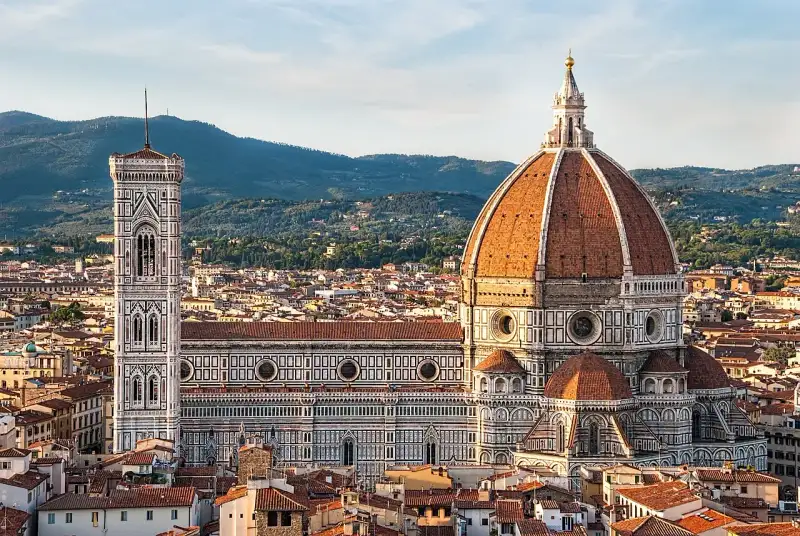
Le Duomo de Florence : L'Aube de la Renaissance Bonjour à tous les amoureux de l'histoire et de l'#architecture ! C'est Lucas Martin. Aujourd'hui, je vous emmène en Toscane, dans la ville qui a changé le cours de l'histoire de l'art européen : Florence. Au centre de ce musée à ciel ouvert trône un chef-d'œuvre absolu, la cathédrale Santa Maria del Fiore, plus connue sous le nom de "Duomo". Une Ambition Démesurée À la fin du 13e siècle, Florence est une république riche, fière et ambitieuse, portée par le commerce de la laine et de la soie. Ses grandes rivales, Pise et Sienne, sont en train de construire de magnifiques cathédrales. Florence ne peut pas être en reste. En 1296, la construction du Duomo débute sous la direction d'Arnolfo di Cambio, dans un style gothique tardif, avec une façade extérieure étonnante, entièrement recouverte de marbre polychrome (vert de Prato, blanc de Carrare et rouge de Sienne). Mais l'ambition des Florentins a créé un problème monumental. Ils avaient prévu à la croisée du transept un espace octogonal de 42 mètres de diamètre. Le problème ? Personne à l'époque ne savait comment construire un dôme d'une telle envergure sans que la structure ne s'effondre sous son propre poids. Pendant plus d'un siècle, la cathédrale est restée béante, à ciel ouvert. Le Génie de Filippo Brunelleschi En 1418, la guilde des marchands de laine organise un grand concours pour trouver enfin un moyen de couvrir l'édifice. C'est un orfèvre devenu architecte, Filippo Brunelleschi, qui remporte le défi avec une idée considérée comme folle : construire le dôme sans aucun échafaudage en bois depuis le sol (il n'y avait pas d'arbres assez grands en Toscane pour cela !). L'ingéniosité de Brunelleschi est la quintessence de l'esprit de la Renaissance. Il a conçu une structure à double coque (un dôme intérieur léger et un dôme extérieur pour protéger des intempéries). Pour empêcher la voûte de s'effondrer, il a inventé un système de pose de briques en arête de poisson ("spina di pesce"), une technique directement inspirée des ruines du Panthéon de #Rome qu'il avait longuement étudiées. Le chantier, qui a duré 16 ans, a été un exploit d'ingénierie mécanique. Brunelleschi a même dû inventer de nouvelles machines de levage (le castello) pour monter les tonnes de briques et de marbre à plus de 50 mètres de haut. La Lanterne et les Portes du Paradis Au sommet de l'immense coupole de briques rouges se trouve la "lanterne" de marbre blanc, ajoutée après la mort de Brunelleschi. Cette lanterne a une double fonction : laisser entrer la lumière et stabiliser la structure en pesant lourdement sur la clé de voûte. Mais le complexe du Duomo ne s'arrête pas à la cathédrale. Juste en face se trouve le Baptistère Saint-Jean. Ne manquez sous aucun prétexte les portes est en bronze doré, sculptées par Lorenzo Ghiberti. Ces portes sont si magnifiquement détaillées et si innovantes dans leur utilisation de la perspective que Michel-Ange lui-même les a surnommées "Les Portes du Paradis" (Porta del Paradiso). Une Esthétique de la Pureté Si l'extérieur du Duomo est une explosion visuelle de marbres colorés, l'intérieur frappe par son austérité. Contrairement aux cathédrales gothiques françaises, Santa Maria del Fiore a très peu de vitraux, laissant de grandes étendues de murs nus, enduits de plâtre gris (pietra serena). Cette sobriété était volontaire, typique de l'idéal de la pré-Renaissance florentine, qui valorisait la rationalité et la géométrie de l'espace plutôt que l'ornementation excessive. Le seul véritable faste intérieur est la fresque monumentale recouvrant l'intérieur de la coupole : Le Jugement Dernier, commencée par Giorgio Vasari en 1572. Une œuvre d'une ampleur vertigineuse, mais dont la complexité maniériste jure un peu avec la pureté architecturale voulue par Brunelleschi. Conseils pour le VisiteurLa montée du Dôme : Oui, il y a 463 marches (étroites et parfois oppressantes), mais l'effort est récompensé. Vous passerez entre les deux coques conçues par Brunelleschi, ce qui permet de comprendre l'ingéniosité de la construction, avant de déboucher sur une vue imprenable sur Florence. Il faut absolument réserver des semaines à l'avance ! Le Campanile de Giotto : Si vous n'avez pas le courage de monter sur le dôme (ou pas de billet), grimpez en haut du campanile adjacent, conçu par le grand peintre Giotto. Vous y aurez la plus belle vue sur le dôme lui-même. Le Museo dell'Opera del Duomo : Ce musée, récemment rénové, se trouve derrière la cathédrale. Il abrite les sculptures originales de la façade, des portes de Ghiberti, et l'émouvante et terrible Pietà Bandini de Michel-Ange. Un incontournable souvent ignoré par la foule.Le Duomo de Florence est la preuve en brique et en marbre du moment exact où l'Europe est sortie du Moyen Âge pour embrasser la raison, les mathématiques et l'humanisme de la Renaissance. C'est l'intelligence humaine triomphant sur la matière. #Florence #Toscane #Brunelleschi #Duomo #RenaissanceItalienne #Architecture #Italie #Florence #Renaissance #Brunelleschi Related InsightsBeyond the Horizon: Unveiling Naoshima and Teshima – Japan's Transformative Art Island Odyssey (Part 2) L'Eterna Seduzione della Costa Azzurra: Tra Scogliere di Porfido e Misteri Belle Époque Insel Rügen im Sommer{ "@context": "https://schema.org", "@type": "FAQPage", "mainEntity": [ { "@type": "Question", "name": "What is the main focus of Le Duomo de Florence : L'Aube de la Renaissance?", "acceptedAnswer": { "@type": "Answer", "text": "Découvrez l'histoire du Duomo de Florence, son incroyable dôme de Brunelleschi et la transition spectaculaire du gothique à la Renaissance." } }, { "@type": "Question", "name": "Who authored the comprehensive guide on Le Duomo de Florence : L'Aube de la Renaissance?", "acceptedAnswer": { "@type": "Answer", "text": "This detailed article and its insights were carefully researched and authored by Lucas Martin." } }, { "@type": "Question", "name": "Where can I find more related content about Travel?", "acceptedAnswer": { "@type": "Answer", "text": "You can explore more articles, detailed reviews, and similar insights by browsing the Related Insights section at the bottom of this article or visiting our dedicated Travel category page." } } ] }
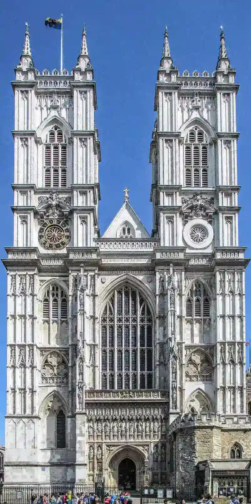
L'Abbaye de Westminster : Le Cœur Royal de Londres Salutations depuis le Royaume-Uni ! Je suis Lucas Martin. Si nous avons exploré la pureté du gothique français, l'exubérance espagnole et la monumentalité allemande, le gothique anglais possède, lui aussi, son joyau unique. Aujourd'hui, nous pénétrons dans un édifice qui résume à lui seul mille ans d'histoire britannique : L'Abbaye de Westminster. Plus qu'une Église, la Maison de la Couronne La Collegiate Church of St Peter at Westminster (son nom officiel) n'est ni une cathédrale ni une église paroissiale. C'est une "Royal Peculiar", ce qui signifie qu'elle est soumise directement à la juridiction du souverain britannique, et non à un évêque. L'abbaye a été fondée à l'origine par le roi Édouard le Confesseur au 11e siècle (dans le style roman). Mais le bâtiment gothique que nous voyons aujourd'hui est l'œuvre du roi Henri III, qui décida en 1245 de la reconstruire dans le nouveau style gothique anglo-français pour y abriter la dépouille d'Édouard (canonisé entre-temps) et en faire la nécropole des monarques anglais. La Scène des Couronnements Depuis Guillaume le Conquérant en 1066, absolument tous les monarques anglais et britanniques (à deux exceptions près) ont été couronnés dans l'Abbaye de Westminster. C'est ici que l'histoire se fait. Au centre de l'abbaye, devant le maître-autel, se trouve le Cosmati Pavement, une mosaïque médiévale italienne d'une beauté époustouflante, qui sert de scène au couronnement. C'est également ici que repose la célèbre Chaise du Couronnement (Coronation Chair), commandée par Édouard Ier en 1296. Cette chaise en chêne abritait la "Pierre de la Destinée" (Stone of Scone), le symbole du trône d'Écosse. C'est sur ce trône érodé par le temps que Charles III a récemment été couronné. Le Gothique Perpendiculaire : La Chapelle d'Henri VII Si l'essentiel de la nef est un bel exemple du gothique primitif anglais, le véritable chef-d'œuvre architectural se trouve à l'arrière : la chapelle d'Henri VII (Lady Chapel). Achevée au 16e siècle, cette chapelle est le summum du style gothique "perpendiculaire". Le plafond est une merveille absolue : une incroyable voûte en éventail (fan vaulting) avec des pendentifs sculptés qui semblent défier la gravité, retombant comme des stalactites de pierre. C'est un niveau de virtuosité dans la sculpture de la pierre que l'on ne trouve presque nulle part ailleurs dans le monde. Le Panthéon Britannique L'Abbaye de Westminster est aussi le grand cimetière national. Plus de 3 300 personnes y sont enterrées ou commémorées. On y trouve la dépouille de nombreux rois et reines, dont Élisabeth Ire, enterrée (ironie de l'histoire) dans le même tombeau que sa rivale catholique, Marie Tudor. Mais ce qui attire des foules de visiteurs, ce sont les sections dédiées aux grands esprits de la nation :Le Coin des Poètes (Poets' Corner) : On y trouve la tombe de Geoffrey Chaucer, Charles Dickens, Rudyard Kipling, et des monuments dédiés à Shakespeare ou Jane Austen. La Nef des Scientifiques : Charles Darwin repose ici, tout comme Sir Isaac Newton. Plus récemment, les cendres de Stephen Hawking y ont été inhumées, à quelques mètres de ses illustres prédécesseurs.L'abbaye honore également le Soldat Inconnu de la Première Guerre Mondiale. Sa tombe est la seule sur laquelle il est strictement interdit de marcher. Conseils de l'Étudiant en Histoire Visiter Westminster peut être une expérience écrasante en raison de la foule et de la densité d'informations.Évitez le milieu de journée : Arrivez dès l'ouverture à 9h30 pour pouvoir apprécier la nef sans être étouffé par les groupes de touristes. Ne manquez pas les cloîtres : Souvent ignorés, les cloîtres adjacents offrent un havre de paix et mènent à la salle capitulaire octogonale (Chapter House), avec son incroyable pilier central et ses peintures murales médiévales. Assistez à l'Evensong : Si vous voulez ressentir la spiritualité du lieu, revenez en fin d'après-midi pour assister aux vêpres chantées par le célèbre chœur de l'abbaye. L'entrée est gratuite pour l'office !Westminster n'est pas seulement un musée ou un mausolée. C'est l'âme de l'histoire britannique condensée entre des murs de pierre. #Londres #WestminsterAbbey #RoyautéAnglaise #ArchitectureGothique #HistoireBritannique #UK #RoyaumeUni #Londres #Royaut #Westminster Related InsightsMezquita-Catedral de Córdoba: El Corazón Omeya The Silk Road Rediscovered: Navigating the Ancient Caravanserais of Central Asia Sustainable Archipelagos: Crafting an Eco‑Conscious Island‑Hopping Blueprint for the Azores{ "@context": "https://schema.org", "@type": "FAQPage", "mainEntity": [ { "@type": "Question", "name": "What is the main focus of L'Abbaye de Westminster : Le Cœur Royal de Londres?", "acceptedAnswer": { "@type": "Answer", "text": "Plongez dans l'histoire de l'Abbaye de Westminster à Londres, joyau du gothique anglais, lieu des couronnements royaux et Panthéon de la nation britannique." } }, { "@type": "Question", "name": "Who authored the comprehensive guide on L'Abbaye de Westminster : Le Cœur Royal de Londres?", "acceptedAnswer": { "@type": "Answer", "text": "This detailed article and its insights were carefully researched and authored by Lucas Martin." } }, { "@type": "Question", "name": "Where can I find more related content about Travel?", "acceptedAnswer": { "@type": "Answer", "text": "You can explore more articles, detailed reviews, and similar insights by browsing the Related Insights section at the bottom of this article or visiting our dedicated Travel category page." } } ] }
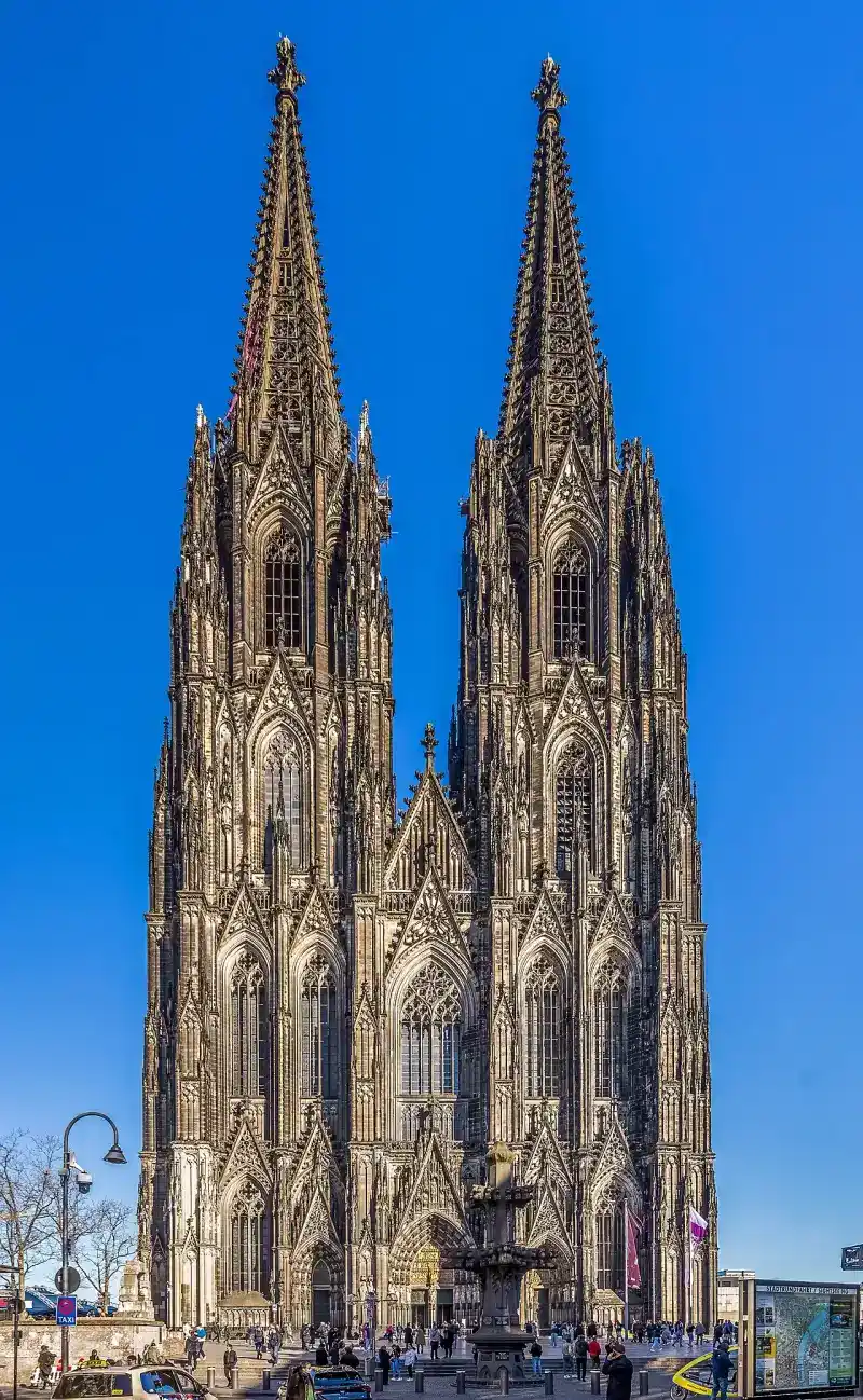
La Cathédrale de Cologne : Un Géant sur le Rhin Amis d'histoire et de vieilles pierres, bonjour ! C'est Lucas Martin. Aujourd'hui, nous traversons la frontière allemande pour nous rendre sur les rives du Rhin. Là, dominant la ligne d'horizon avec une puissance écrasante, se dresse le Kölner Dom (la Cathédrale de Cologne). C'est le monument le plus visité d'Allemagne, et pour une bonne raison : c'est un titan gothique. La Quête des Reliques L'histoire de la cathédrale de Cologne commence avec un trésor. En 1164, l'archevêque de Cologne, Rainald von Dassel, rapporte de Milan les présumées reliques des Trois Rois Mages. Cologne devient instantanément l'un des lieux de pèlerinage les plus importants d'Europe chrétienne, au même titre que Jérusalem, #Rome et Saint-Jacques-de-Compostelle. L'ancienne cathédrale carolingienne n'étant plus suffisante pour accueillir les foules de pèlerins, il est décidé en 1248 de construire un nouvel édifice, dans le tout nouveau style "gothique français" (inspiré par la cathédrale d'Amiens). Le Plus Long Chantier de l'Histoire ? Le Kölner Dom détient un record singulier : son temps de construction. Commencée en 1248, la construction a progressé pendant deux siècles avant de s'arrêter net en 1560, faute de financement et en raison du désintérêt pour le style gothique à l'époque de la Renaissance. Pendant près de 300 ans, la cathédrale est restée inachevée. Une immense grue en bois médiévale est restée perchée sur la tour sud inachevée pendant des siècles, devenant le symbole de la ville. C'est le mouvement romantique du 19e siècle, avec son engouement pour le Moyen Âge et l'identité nationale allemande, qui a relancé le projet. En 1842, le roi de Prusse pose la première pierre de la reprise des travaux. Le miracle, c'est que les plans originaux sur parchemin (mesurant plus de 4 mètres de long !) avaient été retrouvés ! La cathédrale a donc été achevée en 1880, exactement selon le design de 1248. C'est ce qui lui donne cette pureté et cette harmonie architecturale exceptionnelle. Des Dimensions Vertigineuses La façade oculaire est la plus grande du monde pour une église. Ses deux flèches jumelles culminent à 157 mètres de hauteur (elle a d'ailleurs été le plus haut bâtiment du monde pendant 4 ans, avant la construction du Washington Monument). À l'intérieur, la nef est une pure merveille d'élévation, atteignant 43 mètres de hauteur sous voûte. L'impression d'élancement est vertigineuse, accentuée par d'immenses vitraux qui baignent l'intérieur d'une lumière douce. Les Trésors Inestimables La cathédrale abrite bien sûr la célèbre Châsse des Rois Mages (Dreikönigenschrein). C'est le plus grand reliquaire du monde occidental, un chef-d'œuvre d'orfèvrerie en or, argent et pierres précieuses, façonné par Nicolas de Verdun au 12e siècle. Un autre trésor inattendu est le vitrail sud du transept, conçu par l'artiste contemporain Gerhard Richter en 2007. Composé de 11 263 carrés de verre coloré disposés de manière aléatoire (calculée par ordinateur), c'est une touche de modernité audacieuse mais étrangement harmonieuse au cœur du gothique. La Seconde Guerre Mondiale : Le Miracle de Cologne Si vous regardez des photos de Cologne en 1945, la ville est un champ de ruines absolu suite aux intenses bombardements alliés. Au milieu de ce paysage apocalyptique, la cathédrale se dresse, blessée mais debout. Elle a encaissé 14 bombes aériennes majeures. Si elle a survécu, c'est en partie grâce à son #architecture gothique très flexible et à sa structure d'acier ajoutée sur le toit au 19e siècle. Aujourd'hui encore, des réparations en briques plus sombres sont visibles sur les murs extérieurs, cicatrices indélébiles de la guerre. Les Allemands l'ont d'ailleurs noircie au fil du temps (à cause de la pollution et du grès utilisé), ce qui lui donne cet aspect dramatique et imposant. Le saviez-vous ? La cathédrale abrite la cloche de la Saint-Pierre (Der Dicke Pitter), qui pèse 24 tonnes ! C'est la plus grosse cloche du monde en volée libre. L'entendre sonner lors des grandes fêtes religieuses fait vibrer le sol de la ville entière. Cologne est une ville vibrante, et sa cathédrale est son âme. C'est un chef-d'œuvre de persévérance humaine et de grandeur gothique. #Cologne #KoelnerDom #Allemagne #GothiqueAllemand #HistoireEuropéenne #Architecture Related InsightsCarcassonne: Stepping Back into the Medieval World Beyond the Clouds: Unveiling the Eternal Spirit of Georgia’s Caucasus Palawan’s Hidden Lagoons: The Philippines’ Most Breathtaking Coastal Escapes You Can’t Miss{ "@context": "https://schema.org", "@type": "FAQPage", "mainEntity": [ { "@type": "Question", "name": "What is the main focus of La Cathédrale de Cologne : Un Géant sur le Rhin?", "acceptedAnswer": { "@type": "Answer", "text": "Explorez la Cathédrale de Cologne, chef-d'œuvre du gothique allemand abritant les reliques des Rois Mages. Un monument de résilience et d'histoire." } }, { "@type": "Question", "name": "Who authored the comprehensive guide on La Cathédrale de Cologne : Un Géant sur le Rhin?", "acceptedAnswer": { "@type": "Answer", "text": "This detailed article and its insights were carefully researched and authored by Lucas Martin." } }, { "@type": "Question", "name": "Where can I find more related content about Travel?", "acceptedAnswer": { "@type": "Answer", "text": "You can explore more articles, detailed reviews, and similar insights by browsing the Related Insights section at the bottom of this article or visiting our dedicated Travel category page." } } ] }
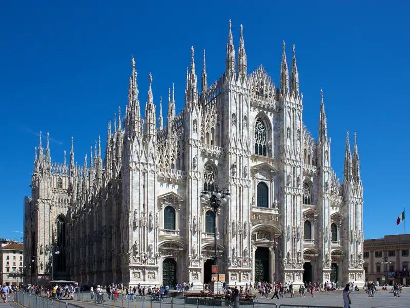
Le Dôme de Milan : L'Élégance de Marbre Blanc Salut les explorateurs du passé ! C'est Lucas. Poursuivons notre tour d'Europe des géants de pierre. Quittons la #France et l'Espagne pour nous diriger vers l'Italie. À Milan, sur une place bourdonnante d'activité, se dresse une montagne de marbre blanc aux proportions irréelles : Il Duomo di Milano. L'Exception Gothique Italienne Il faut savoir que l'Italie n'a jamais été particulièrement fan du style gothique français. Les Italiens préféraient les dômes ronds, les proportions classiques et les fresques. Le Duomo de Milan est l'exception qui confirme la règle. C'est l'un des rares édifices en Italie à avoir embrassé pleinement le gothique rayonnant et flamboyant nord-européen. Initié en 1386 par l'archevêque Antonio da Saluzzo et le seigneur Gian Galeazzo Visconti, le Duomo avait une ambition politique claire : rivaliser avec les grandes cathédrales d'Europe du Nord et asseoir la puissance de la dynastie Visconti. Une Forêt de Marbre Ce qui frappe immédiatement le visiteur, c'est le matériau. Contrairement à la pierre calcaire blonde de #Paris, le Duomo est entièrement revêtu de marbre de Candoglia, un marbre blanc-rose extrait d'une carrière spéciale près du lac Majeur. Les Visconti ont même creusé un système de canaux (les fameux Navigli) spécialement pour acheminer ces immenses blocs de marbre jusqu'au centre de Milan. Le résultat ? Un édifice qui semble scintiller sous le soleil de Lombardie. Avec ses 135 flèches (guglie) et plus de 3 400 statues extérieures, la toiture de la cathédrale ressemble à une forêt pétrifiée ou à un palais de glace. C'est le triomphe absolu du détail. La Madonnina : Protectrice de la Cité Si vous levez les yeux vers la plus haute flèche, à 108 mètres d'altitude, vous apercevrez une statue dorée qui brille de mille feux. C'est la Madonnina (la petite Madone), installée en 1774. Symbole de Milan, elle est recouverte de feuilles d'or véritable. La tradition milanaise exigeait qu'aucun bâtiment de la ville ne puisse dépasser la Madonnina. Lorsque le premier gratte-ciel milanais (la tour Pirelli) a été construit dans les années 1950 et l'a dépassée, une copie de la Madonnina a été placée sur son toit pour respecter la tradition ! Une Construction sur Six Siècles Comme beaucoup de cathédrales, le Duomo n'a pas été construit en un jour. En fait, il a fallu près de six siècles pour l'achever ! La façade, par exemple, est un curieux mélange. Commencée à la Renaissance, elle mêle des éléments gothiques, baroques et néo-gothiques. C'est d'ailleurs Napoléon Bonaparte, sur le point d'être couronné roi d'Italie en 1805, qui a ordonné et financé l'achèvement de la façade ! La Visite des Terrasses : Le Point d'Orgue En tant que passionné d'#architecture, le conseil absolu que je peux vous donner est de monter sur les terrasses du Duomo. Vous pouvez y accéder par des escaliers (pour les plus courageux) ou par un ascenseur. Marcher sur le toit du Duomo est une expérience indescriptible. Vous vous promenez littéralement à travers cette forêt de flèches, côtoyant de près les gargouilles et les saints de marbre. Par temps clair, la vue s'étend par-delà la plaine du Pô, jusqu'aux sommets enneigés des Alpes. C'est le lieu idéal pour comprendre la folie et le génie des bâtisseurs médiévaux. L'Intérieur : Immensité et Mystère Si l'extérieur est éclatant, l'intérieur est plongé dans une pénombre solennelle. La nef, l'une des plus hautes du monde, est divisée par 52 immenses piliers fasciculés (un pour chaque semaine de l'année). Ne manquez pas de chercher la statue de Saint-Barthélemy écorché vif, sculptée par Marco d'Agrate. Elle est d'un réalisme anatomique terrifiant, le saint portant sa propre peau sur ses épaules comme un manteau. Un autre détail fascinant est le clou sacré (le Saint Mors), supposément issu de la Vraie Croix, suspendu très haut dans l'abside, signalé par une petite lumière rouge. Le Duomo de Milan est une démonstration de force, un défi à la raison et un triomphe de l'artisanat humain. C'est une cathédrale qui n'a pas son pareil dans le monde, un "hérisson de marbre" (comme l'appelait Mark Twain) qui mérite absolument votre visite. #Milan #Duomo #Italie #ArchitectureGothique #VoyageEnItalie #HistoireDeLArt Related InsightsChloe Tremblay’s Epic 10-Day Iceland Ring Road Adventure: A Budgeter’s Paradise and Luxury Dream The Whispering Paths: Tracing Europe's Forgotten Salt Roads, From Alpine Mines to Adriatic Shores The Faroe Islands: Where Nordic Wilderness Meets Photographic Magic{ "@context": "https://schema.org", "@type": "FAQPage", "mainEntity": [ { "@type": "Question", "name": "What is the main focus of Le Dôme de Milan (Il Duomo) : L'Élégance de Marbre Blanc?", "acceptedAnswer": { "@type": "Answer", "text": "Découvrez le Dôme de Milan, la plus grande église gothique d'Italie. Une forêt de flèches en marbre de Candoglia qui défie le temps et la gravité." } }, { "@type": "Question", "name": "Who authored the comprehensive guide on Le Dôme de Milan (Il Duomo) : L'Élégance de Marbre Blanc?", "acceptedAnswer": { "@type": "Answer", "text": "This detailed article and its insights were carefully researched and authored by Lucas Martin." } }, { "@type": "Question", "name": "Where can I find more related content about Travel?", "acceptedAnswer": { "@type": "Answer", "text": "You can explore more articles, detailed reviews, and similar insights by browsing the Related Insights section at the bottom of this article or visiting our dedicated Travel category page." } } ] }
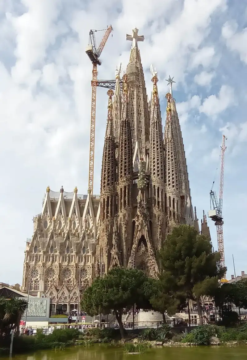
La Sagrada Familia : Le Gothique Réinventé par Gaudí Bonjour à tous, passionnés d'#architecture et de voyages ! Lucas Martin au rapport. Si mon cœur de futur historien bat la chamade pour les cathédrales gothiques françaises, il m'est impossible d'ignorer la manière dont ce style a été sublimé, déconstruit et transcendé en Espagne. Aujourd'hui, nous partons pour Barcelone, à la découverte de la Sagrada Familia, le chef-d'œuvre inachevé d'Antoni Gaudí. L'Héritage Gothique et la Vision Moderniste La Sagrada Familia n'a pas commencé comme un projet moderniste. En 1882, l'architecte Francisco de Paula del Villar initie la construction avec un plan strictement néo-gothique. Cependant, des désaccords surviennent, et en 1883, un jeune architecte de 31 ans, Antoni Gaudí, reprend le projet. Gaudí respecte le plan en croix latine initial, mais il va révolutionner l'élévation et la structure. Pour lui, le style gothique traditionnel était imparfait car il nécessitait l'usage de "béquilles" (les arcs-boutants) pour se tenir debout. Inspiré par la #nature, Gaudí conçoit un système d'arborescence : des colonnes inclinées qui se ramifient comme les branches d'un arbre, soutenant les voûtes de manière organique et autonome. La Nature comme Maître d'Œuvre La véritable révolution de la Sagrada Familia réside dans son intégration totale de la nature. Gaudí affirmait que l'originalité consiste à "revenir à l'origine". L'intérieur de la basilique ressemble à une forêt géante. Les colonnes, faites de porphyre, de basalte, de granit et de pierre, varient en épaisseur et en couleur. La lumière pénètre par des fenêtres savamment orientées, créant un kaléidoscope de couleurs. Au lever du soleil, les teintes froides (bleus, verts) baignent la nef, symbolisant la naissance. Au coucher du soleil, les tons chauds (rouges, oranges) embrasent l'intérieur, représentant la passion et la mort. C'est une expérience spirituelle et sensorielle unique au monde. Les Trois Façades de l'Humanité La cathédrale est pensée comme une Bible ouverte, racontant la vie du Christ à travers trois façades monumentales :La Façade de la Nativité : Orientée vers l'est (le lever du soleil), elle est la seule construite du vivant de Gaudí. C'est une explosion de détails sculpturaux, grouillant de vie végétale, animale et humaine. La Façade de la Passion : Orientée vers l'ouest. Contrairement à la Nativité, cette façade (achevée bien plus tard) est austère, angulaire et dépouillée, symbolisant la souffrance, la mort et le sacrifice. Josep Maria Subirachs y a sculpté des figures aux lignes dures et dramatiques. La Façade de la Gloire : Orientée vers le sud, elle sera la plus imposante et deviendra l'entrée principale une fois terminée. Elle symbolisera la résurrection et la gloire céleste.Les Tours : Un Lien vers le Ciel Le projet final prévoit 18 tours : 12 pour les apôtres, 4 pour les évangélistes, 1 pour la Vierge Marie (inaugurée récemment avec son étoile lumineuse) et la tour centrale dédiée à Jésus-Christ, qui culminera à 172,5 mètres. Gaudí a délibérément choisi cette hauteur pour être juste un peu plus bas que la colline de Montjuïc. Pour lui, l'œuvre de l'homme ne devait jamais dépasser l'œuvre de Dieu (la nature). Quand Sera-t-elle Terminée ? La question que tout le monde se pose : à quand la fin ? Pendant des décennies, le financement dépendait uniquement des dons privés, ce qui expliquait la lenteur des travaux (Gaudí disait d'ailleurs : "Mon client n'est pas pressé"). Aujourd'hui, grâce aux millions de visiteurs annuels, le financement est assuré. La date symbolique de 2026, marquant le centenaire de la mort de Gaudí (renversé par un tramway en 1926), est souvent évoquée, bien que la pandémie ait ralenti le calendrier. Le Verdict de l'Historien La Sagrada Familia est souvent critiquée par les puristes pour son exubérance, voire qualifiée de "monstre" par certains écrivains (George Orwell la détestait). Pourtant, en tant qu'étudiant en histoire, je la vois comme l'évolution ultime du rêve gothique. Les bâtisseurs de cathédrales du Moyen Âge cherchaient la lumière et la hauteur ; Gaudí a accompli leur rêve en utilisant la géométrie et la nature. Conseils de Voyage :Réservez vos billets en ligne des mois à l'avance, la file d'attente est colossale. Prenez le temps de visiter le musée en sous-sol, il explique en détail les modèles en fil et poids inversés utilisés par Gaudí pour calculer les charges.C'est un chantier permanent, une œuvre vivante. Allez la voir, et laissez-vous transporter par ce génie absolu. #SagradaFamilia #Barcelone #Gaudí #Architecture #VoyageEnEspagne #Modernisme #Espagne #Barcelone #Gaud #Modernisme Related InsightsCanada's Rocky Mountains: Emerald Lakes and Alpine Adventures Georgia’s Caucasus Mountains: Where Medieval Villages, Ancient Wine, and Epic Hikes Collide Discover Luang Prabang's Hidden Gems{ "@context": "https://schema.org", "@type": "FAQPage", "mainEntity": [ { "@type": "Question", "name": "What is the main focus of La Sagrada Familia : Le Gothique Réinventé par Gaudí?", "acceptedAnswer": { "@type": "Answer", "text": "Plongez dans l'univers fascinant de la Sagrada Familia à Barcelone, où Antoni Gaudí a transcendé l'architecture gothique pour créer un chef-d'œuvre moderniste." } }, { "@type": "Question", "name": "Who authored the comprehensive guide on La Sagrada Familia : Le Gothique Réinventé par Gaudí?", "acceptedAnswer": { "@type": "Answer", "text": "This detailed article and its insights were carefully researched and authored by Lucas Martin." } }, { "@type": "Question", "name": "Where can I find more related content about Travel?", "acceptedAnswer": { "@type": "Answer", "text": "You can explore more articles, detailed reviews, and similar insights by browsing the Related Insights section at the bottom of this article or visiting our dedicated Travel category page." } } ] }
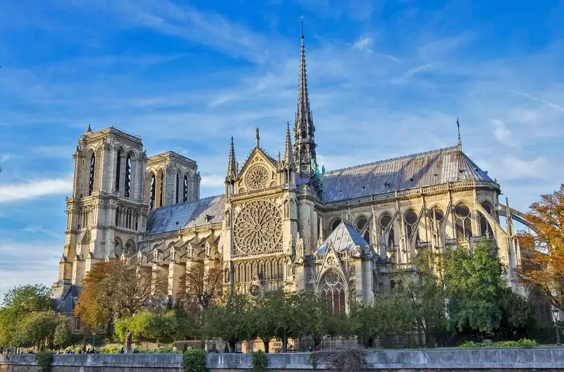
Notre-Dame de #Paris : La Résilience du Chef-d'œuvre Gothique Bienvenue à tous les passionnés d'histoire et d'#architecture. Je suis Lucas Martin, étudiant en histoire, et aujourd'hui je vous emmène au cœur de la #France, sur l'Île de la Cité, pour redécouvrir l'un des monuments les plus emblématiques au monde : Notre-Dame de Paris. Un Chef-d'œuvre Né de la Boue et de la Foi La construction de la cathédrale Notre-Dame de Paris a débuté en 1163, sous l'impulsion de l'évêque Maurice de Sully. À cette époque, Paris émergeait comme le centre intellectuel et politique de l'Europe. Il fallait une cathédrale digne de ce nouveau statut. Pendant près de deux siècles, des artisans, des tailleurs de pierre, des charpentiers et des maîtres verriers ont travaillé sans relâche pour élever cet édifice majestueux vers les cieux. L'architecture gothique de Notre-Dame est caractérisée par ses innovations techniques spectaculaires. L'utilisation des arcs-boutants a permis de soutenir les murs très hauts et d'ouvrir de vastes espaces pour les vitraux. Ces arcs, tels de gigantesques bras de pierre, ne sont pas seulement structurels ; ils ajoutent une esthétique élancée et aérienne à la cathédrale. L'Art des Vitraux : La Lumière Divine L'une des merveilles absolues de Notre-Dame réside dans ses immenses rosaces. La rosace nord, avec ses 13 mètres de diamètre, est un chef-d'œuvre de géométrie et de couleur, datant du 13e siècle. Lorsque la lumière du soleil traverse ces milliers de morceaux de verre coloré, elle inonde la nef d'une lueur mystique. Au Moyen Âge, la lumière n'était pas seulement fonctionnelle ; elle était théologique. On croyait que Dieu était lumière (Lux), et les cathédrales gothiques étaient conçues pour capturer cette essence divine. Les vitraux servaient également de "Bible de pierre" pour une population largement analphabète, racontant les histoires de l'Ancien et du Nouveau Testament. Les Gargouilles et les Chimères Il est impossible de parler de Notre-Dame sans évoquer ses fameuses gargouilles et chimères. Contrairement à une idée reçue, les gargouilles ont une fonction purement pratique : elles servent à évacuer l'eau de pluie loin des murs pour éviter la corrosion de la pierre. Les chimères, en revanche, sont de pures décorations ajoutées lors de la restauration menée par Eugène Viollet-le-Duc au 19e siècle. Ces créatures fantastiques, mi-bêtes mi-démons, contemplent Paris du haut des tours. Elles symbolisent le mal repoussé hors de l'église, tout en ajoutant une touche romantique et sombre à l'édifice, immortalisée par Victor Hugo dans son célèbre roman. Les Reliques Sacrées Notre-Dame est bien plus qu'une prouesse architecturale ; c'est un sanctuaire spirituel. Elle abrite l'une des reliques les plus vénérées du monde chrétien : la Sainte Couronne d'épines, acquise par le roi Saint-Louis au 13e siècle. Pour abriter cette relique inestimable, Louis IX avait d'ailleurs fait construire la Sainte-Chapelle, un autre joyau gothique situé à quelques pas de Notre-Dame. Aujourd'hui encore, la conservation de ces reliques fait l'objet d'une vénération particulière. Le Tragique Incendie de 2019 et la Résurrection Le 15 avril 2019, le monde entier a retenu son souffle en voyant les flammes ravager la toiture de Notre-Dame et provoquer l'effondrement de la célèbre flèche de Viollet-le-Duc. La "forêt", cette charpente en bois de chêne datant du 13e siècle, est partie en fumée. Pourtant, dans cette tragédie, la résilience du chef-d'œuvre s'est manifestée. La structure principale, les tours et la majeure partie des voûtes ont tenu bon. Aujourd'hui, un chantier de restauration titanesque est en cours, mêlant savoir-faire traditionnels et technologies de pointe (comme la numérisation 3D). Ce chantier est une preuve vivante que la cathédrale continue de fédérer l'humanité, bien au-delà de ses frontières. Conseils aux Voyageurs Si vous prévoyez de visiter Paris dans les années à venir, voici quelques conseils pour apprécier Notre-Dame :Prenez du recul : Les meilleures vues sur la cathédrale s'obtiennent depuis les quais de la Seine, particulièrement au coucher du soleil. Explorez l'Île de la Cité : Ne vous limitez pas à la cathédrale. Les ruelles de l'île, la Conciergerie et la place Dauphine valent le détour. Plongez dans l'histoire : Lisez "Notre-Dame de Paris" de Victor Hugo avant votre visite. Ce roman vous donnera une perspective unique sur l'âme de l'édifice.Notre-Dame de Paris n'est pas seulement un tas de pierres ; c'est le cœur battant de la France. Elle a survécu aux guerres, aux révolutions et aux incendies. Elle continuera de se tenir debout, témoin silencieux mais puissant de notre histoire commune. Merci de m'avoir accompagné dans cette exploration. L'histoire s'écrit chaque jour, et nous en sommes les témoins. #NotreDame #Paris #ArchitectureGothique #HistoireDeFrance #VoyageCulturel #PatrimoineMondial #France #Paris #Gothique #Cathdrales Related InsightsTerme di Caracalla: Il Lusso del Benessere Romano Gobeklitepe: The First Temple Beyond the Great Wall: Uncovering the Ming Dynasty Watchtowers in Hebei{ "@context": "https://schema.org", "@type": "FAQPage", "mainEntity": [ { "@type": "Question", "name": "What is the main focus of Notre-Dame de Paris : La Résilience du Chef-d'œuvre Gothique?", "acceptedAnswer": { "@type": "Answer", "text": "Découvrez l'histoire fascinante de Notre-Dame de Paris, chef-d'œuvre de l'architecture gothique française, sa résilience à travers les siècles et ses secrets." } }, { "@type": "Question", "name": "Who authored the comprehensive guide on Notre-Dame de Paris : La Résilience du Chef-d'œuvre Gothique?", "acceptedAnswer": { "@type": "Answer", "text": "This detailed article and its insights were carefully researched and authored by Lucas Martin." } }, { "@type": "Question", "name": "Where can I find more related content about Travel?", "acceptedAnswer": { "@type": "Answer", "text": "You can explore more articles, detailed reviews, and similar insights by browsing the Related Insights section at the bottom of this article or visiting our dedicated Travel category page." } } ] }
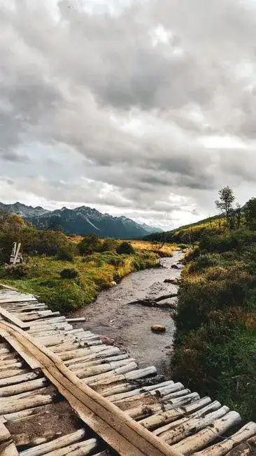
-
 Pierre Dubois
 - 03 Jul, 2026 02:54
Les Sentinelles Solitaires du Bout du Monde : Une Odyssée vers les Phares Oubliés de Patagonie Chilienne
Dans un monde où chaque recoin de la carte semble avoir été scruté, digitalisé et rendu accessible d'un simple clic, il persiste des lieux qui murmurent encore des histoires d'isolement, de résilience et de beauté brute. Des endroits où la civilisation cède sa place à l'immensité, et où la main de l'homme se manifeste non par la conquête, mais par une humble veille. C'est à la rencontre de ces sentinelles silencieuses, les phares solitaires de la Patagonie chilienne, que je vous convie aujourd'hui, loin des sentiers battus et des clichés touristiques. Non pas une simple description de destinations, mais une immersion dans l'âme d'une région façonnée par le vent, le froid et l'océan, à travers les yeux de ces structures lumineuses. L'Appel des Confins : Pourquoi les Phares ? Pourquoi s'intéresser à des phares, ces monuments fonctionnels que l'on perçoit souvent comme de simples balises maritimes ? Parce qu'en Patagonie chilienne, ils sont bien plus que cela. Ils sont les dépositaires d'un héritage héroïque, les témoins impassibles d'une navigation audacieuse, et les emblèmes d'une terre où la nature dicte encore sa loi suprême. La Patagonie, ce nom seul évoque des fjords profonds, des glaciers bleutés, des forêts impénétrables et des vents furieux balayant des archipels infinis. C'est un labyrinthe d'îles et de canaux, une côte déchiquetée de plus de 4 000 kilomètres, où la mer est à la fois nourricière et implacable. Dans ce contexte, les phares sont des points de repère vitaux, des lumières d'espoir dans l'obscurité, et le dernier lien de l'homme avec le continent avant l'immensité du Pacifique. Mon exploration ne se contente pas d'énumérer ces phares ; elle cherche à comprendre leur âme, l'histoire des hommes et des femmes qui les ont habités, et la nature implacable qui les entoure. C'est un pèlerinage vers l'extrême, une quête de solitude et de compréhension d'une existence en marge. Une Géographie de l'Extrême : La Patagonie, Terre des Défis La Patagonie chilienne est une mosaïque de paysages d'une beauté époustouflante et d'une rudesse intimidante. Des îles de Chiloé au nord, jusqu'au Cap Horn à l'extrême sud, cette région est un défi constant. Les conditions météorologiques y sont parmi les plus imprévisibles et violentes de la planète : des tempêtes soudaines, des vents catabatiques déchaînés, des pluies incessantes et des brouillards épais qui peuvent engloutir un navire en quelques instants. Les courants marins sont puissants, les canaux étroits et traîtres, et les côtes souvent inabordables, faites de falaises abruptes et de rochers acérés. C'est dans cet environnement hostile que les premiers marins et explorateurs se sont aventurés, affrontant l'inconnu avec courage. Magellan, Drake, Bougainville, Darwin – tous ont laissé leur empreinte dans ces eaux tumultueuses. Et avec eux, la nécessité de baliser ces passages dangereux est devenue évidente. Les phares ont alors commencé à surgir, un par un, comme des sentinelles solitaires chargées de veiller sur le passage des navires et la sécurité de leurs équipages. Les Pionniers de la Lumière : Histoire et Sacrifices L'histoire des phares de Patagonie est indissociable de celle de la marine chilienne et des pionniers qui ont bravé l'isolement. La construction même de ces structures était une prouesse d'ingénierie et de logistique. Les matériaux devaient être acheminés par bateau, souvent depuis des milliers de kilomètres, puis hissés sur des falaises vertigineuses ou assemblés sur des îlots balayés par les vagues. Chaque phare est une victoire de la volonté humaine sur les éléments. Mais la véritable épopée réside dans la vie des gardiens de phare. Imaginez-vous, isolé pendant des mois, voire des années, avec pour seule compagnie le bruit incessant de la mer, le vent qui hurle et le scintillement régulier de votre lanterne. Ces hommes et parfois ces femmes ont fait preuve d'une résilience extraordinaire. Leurs journées étaient rythmées par l'entretien de la lentille, le réapprovisionnement en combustible (huile de colza, puis pétrole, puis électricité), la maintenance du mécanisme, et la surveillance constante de l'horizon. C'était une vie de discipline rigoureuse, de solitude profonde et de responsabilité immense, car des vies dépendaient de leur vigilance. Les familles des gardiens partageaient souvent cet isolement, les enfants étant éduqués à distance ou par leurs parents, et les provisions arrivant par bateau, parfois avec des mois de retard. La maladie, les accidents, l'ennui et la monotonie étaient des défis quotidiens. Pourtant, l'attachement à leur tâche et la majesté sauvage de leur environnement étaient souvent les raisons qui les poussaient à rester.Phares Emblématiques : Lumières dans le Labyrinthe Parmi la myriade de phares et de balises qui parsèment la Patagonie chilienne, certains se distinguent par leur histoire, leur emplacement spectaculaire ou leur rôle stratégique.Le Faro San Isidro : La Porte du Détroit de Magellan Situé à l'extrémité de la péninsule de Brunswick, à environ 75 kilomètres au sud de Punta Arenas, le Faro San Isidro est le phare le plus méridional du continent américain accessible par la route (bien que cette route soit souvent impraticable). Érigé en 1904, il marque l'entrée occidentale du Détroit de Magellan pour les navires venant du Pacifique. Sa tour octogonale blanche se dresse majestueusement sur une falaise, offrant des vues imprenables sur les eaux glacées et les montagnes enneigées. Une randonnée de plusieurs heures est nécessaire pour l'atteindre, traversant des forêts subpolaires denses, un voyage qui récompense les courageux par une rencontre avec un monument chargé d'histoire et une nature intacte. Il n'est plus gardienné, mais son aura persiste.Le Faro Cabo Froward : Le Point le Plus Méridional du Continent Plus au sud encore que San Isidro, au bout d'une péninsule escarpée et presque inaccessible, se trouve le Cabo Froward, le point le plus méridional du continent américain, juste avant la Terre de Feu. Le phare qui y a été construit est l'un des plus isolés. Il est souvent visité lors d'expéditions maritimes, mais l'approche terrestre est une aventure extrême, réservée aux trekkeurs les plus aguerris, traversant des tourbières, des forêts denses et des rivières. Ce phare symbolise la fin de la terre ferme et le début de l'immensité océanique. Au sommet du cap se dresse une croix imposante, la Cruz de los Mares, un hommage aux marins qui ont péri dans ces eaux.Les Phares du Canal Beagle et de la Terre de Feu En s'aventurant plus à l'est et au sud, vers la Terre de Feu, on trouve des phares encore plus emblématiques et connus, comme le célèbre "Phare des Éclaireurs" (Les Éclaireurs Lighthouse) près d'Ushuaia (côté argentin, mais représentatif de la région), ou des phares plus modestes mais tout aussi vitaux le long du Canal Beagle. Ces lumières guident les navires à travers des passages étroits, où les fjords se transforment en canaux et où les vents de l'Antarctique se font sentir avec une force redoublable.Le Faro Evangelistas : La Sentinelle du Pacifique Peut-être le plus mythique de tous, le Faro Evangelistas est une légende. Situé sur un îlot rocheux battu par les vagues, à l'entrée ouest du Détroit de Magellan, c'est l'un des phares les plus exposés et les plus difficiles d'accès au monde. Bâti en 1895 par l'ingénieur écossais George Slight, sa construction fut une prouesse incroyable. Des mois de travail acharné, des conditions climatiques dantesques, des tempêtes qui emportaient les équipements... Tout concourait à rendre ce projet quasi impossible. Les gardiens qui y ont vécu pendant des décennies ont connu l'isolement le plus total, ravitaillés seulement quelques fois par an. Aujourd'hui automatisé, il continue de veiller, un symbole de l'ingéniosité humaine face à la furie des éléments. Son image, avec ses vagues s'écrasant contre la tour, est gravée dans l'imaginaire des marins.La Vie Autour des Phares : Écosystèmes et Faune Marine L'isolement de ces phares a eu un effet secondaire remarquable : il a préservé des écosystèmes marins et terrestres uniques. Les eaux froides et riches de la Patagonie sont un sanctuaire pour une faune marine abondante. Autour de ces îlots et côtes déchiquetées, on peut observer des baleines à bosse, des orques, des dauphins de Commerson, des lions de mer à crinière (otaries de Patagonie), et une multitude d'oiseaux marins. De nombreuses colonies de manchots de Magellan, de cormorans impériaux et d'albatros vivent sur ces îles et falaises isolées, nichant à l'abri des prédateurs terrestres. La présence de ces phares, paradoxalement, a contribué à maintenir la tranquillité de ces habitats en dissuadant une exploration trop intensive. Une expédition vers ces phares est souvent une occasion rare d'observer la faune dans son habitat naturel et immaculé.Voyager vers l'Inaccessible : Une Quête Personnelle Visiter ces phares n'est pas une simple excursion. C'est une expédition, une immersion. Pour la plupart d'entre eux, il n'existe pas de routes ou de liaisons régulières. Il faut affréter des bateaux (souvent des voiliers d'expédition ou de petits navires de croisière spécialisés), ou entreprendre des treks de plusieurs jours dans des conditions météorologiques imprévisibles. Cela exige une planification minutieuse, un équipement adapté et un esprit d'aventure inébranlable. C'est une opportunité unique de se déconnecter du rythme effréné du monde moderne, de se confronter à la grandeur de la nature et de méditer sur la place de l'homme dans cet univers sauvage. L'expérience de se tenir au pied d'un phare balayé par les vents, d'imaginer la vie des gardiens d'antan et de contempler l'horizon infini, est profondément transformatrice. C'est un rappel puissant de notre petitesse face à l'immensité et de notre capacité à persévérer même dans les conditions les plus rudes. L'Héritage des Phares : Plus Qu'une Lumière Aujourd'hui, de nombreux phares sont automatisés, les gardiens humains ayant été remplacés par la technologie. Mais leur essence demeure. Ils continuent de symboliser la ténacité, la persévérance et l'ingéniosité humaine. Ils nous rappellent l'importance de la lumière dans l'obscurité, non seulement pour les marins, mais aussi comme métaphore de l'espoir et du guidage dans nos propres vies. L'odyssée vers les phares oubliés de Patagonie chilienne est un voyage aux confins du monde, une immersion dans une histoire maritime fascinante et une confrontation avec une nature à la fois magnifique et redoutable. C'est une invitation à redécouvrir le sens de l'aventure, de l'isolement choisi, et de l'admiration pour ces sentinelles de lumière qui, contre vents et marées, continuent de veiller sur le bout du monde. Que leur lumière continue de briller, guidant non seulement les navires, mais aussi l'esprit de tous ceux qui osent rêver d'exploration et de découverte.#PatagonieChilienne #PharesIsolés #VoyageAventure #ExplorationMarine #NatureSauvage #ChiliSecret Related InsightsLa Giralda: El Minarete de Sevilla 'Hallstatt: Where Time Carved Its Name into the Alps and Salt Whispered Eternity' Die Moorgeister des Hohen Venns: Eine Reise in die vergessenen Welten der Torfstecher{ "@context": "https://schema.org", "@type": "FAQPage", "mainEntity": [ { "@type": "Question", "name": "What is the main focus of Les Sentinelles Solitaires du Bout du Monde : Une Odyssée vers les Phares Oubliés de Patagonie Chilienne?", "acceptedAnswer": { "@type": "Answer", "text": "Découvrez le récit captivant des phares mythiques et inaccessibles qui veillent sur les eaux tumultueuses de la Patagonie chilienne, un voyage au cœur de l'isolement et de l'histoire maritime." } }, { "@type": "Question", "name": "Who authored the comprehensive guide on Les Sentinelles Solitaires du Bout du Monde : Une Odyssée vers les Phares Oubliés de Patagonie Chilienne?", "acceptedAnswer": { "@type": "Answer", "text": "This detailed article and its insights were carefully researched and authored by Pierre Dubois." } }, { "@type": "Question", "name": "Where can I find more related content about Travel?", "acceptedAnswer": { "@type": "Answer", "text": "You can explore more articles, detailed reviews, and similar insights by browsing the Related Insights section at the bottom of this article or visiting our dedicated Travel category page." } } ] }
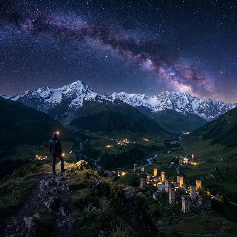
- John Explorer
- 03 Jul, 2026 01:15
Beyond the Watchtowers: Unearthing Svaneti's Hidden Star-Stone Calendar
There are places on Earth where time doesn't merely slow; it calcifies, hardening into the very stone of the mountains, the timber of #ancient homes, the wrinkles on the faces of its oldest inhabitants. Svaneti, a fortress of a region tucked high in the Greater Caucasus of Georgia, is one such place. Its iconic defensive towers, or koshki, pierce the sky like ancient sentinels, silent witnesses to millennia of fierce independence. Yet, beneath their watchful gaze, and beyond the well-trodden paths to these architectural wonders, lies a secret far older, far more enigmatic than any medieval fortification: a celestial calendar etched not in parchment or clay, but in the very bedrock of the Earth, a scattered constellation of megaliths known only to a precious few. My #journey began not with a #travel brochure, but with a forgotten footnote in a faded, Georgian-language ethnography from the early 20th century. The text, a dense academic tome on Svan customs and folklore, briefly alluded to 'heaven-touching stones' – Tsiskhela Kvani – said to mark the passages of the sun and stars for purposes now lost to memory. The author dismissed them as mere local superstitions, perhaps misidentified boundary markers. But the phrase lodged itself in my mind, a splinter of intrigue in a vast landscape of known #history. 'Heaven-touching.' What could that mean in a land already so close to the heavens? The Whisper of a Forgotten Cosmology Svaneti has always captivated me. Its isolation, its unique unwritten language (Svan, a distinct Kartvelian tongue), its fierce warrior traditions, and its profound adherence to ancient customs speak of a cultural crucible forged in extreme conditions. The Svans, with their deep reverence for their ancestors and the mountainous terrain, seemed like the perfect candidates for having preserved such an archaic astronomical practice. My initial research was a frustrating tangle of dead ends. Modern Georgian archaeology has largely focused on more accessible, better-documented sites. The concept of a widespread megalithic astronomical complex in Svaneti was met with polite skepticism, or outright bewilderment. No official maps noted them; no tourist guides mentioned them. They existed, if at all, purely in the realm of local oral tradition, or perhaps, simply didn't exist. But the spark of an idea, once ignited, becomes a bonfire for the explorer. I imagined ancient Svans, in their high mountain valleys, gazing up at the impossibly clear, star-strewn skies, their lives intimately linked to the cycles of the sun and moon, the rhythms of planting and harvest dictated by celestial movements. It was more than a practical need; it was a spiritual imperative, a way to connect their earthly existence to the cosmic order. My quest, then, was not merely to find stones, but to uncover a lost cosmology, to understand how a civilization, isolated by formidable peaks, understood its place in the universe. It felt less like a travel blog entry and more like an archaeological detective story, one where the clues were written in stone and the archives were held in the memories of a people fiercely protective of their heritage. Navigating the Labyrinth of Svaneti's Peaks and Perceptions The road to Svaneti is an adventure in itself. From Zugdidi, the drive winds through increasingly dramatic gorges, past emerald valleys, until the true scale of the Caucasus reveals itself. Mestia, the regional capital, bustles with a growing, albeit still nascent, tourism industry. But my interest lay far beyond Mestia, in the more remote villages that cling precariously to the mountain slopes, where electricity is intermittent and paved roads are a luxury. My first weeks were spent traversing the upper reaches of the Enguri valley, visiting villages like Ushguli (a #UNESCO World Heritage site known for its concentration of koshki), Adishi, and Khalde. I spoke with elders, often through multiple layers of translation, seeking any mention of Tsiskhela Kvani. Most conversations were cordial but fruitless. There were stories of powerful spirits, of sacred groves, of boundary markers, but nothing that definitively pointed to astronomical observatories. The Svans, renowned for their hospitality, are also reserved, their ancient ways not easily shared with outsiders. I encountered the usual challenges of remote travel: treacherous mountain paths, sudden changes in weather, the occasional territorial shepherd dog. More significantly, I faced the challenge of translating a deeply ingrained, almost instinctual connection to the land and sky into something comprehensible to a modern, scientific mind. The concept of 'astronomy' as we understand it didn't quite fit. What I was looking for was a system, a set of markers that served a calendrical or observational purpose, however rudimentary. Then, in a tiny, almost forgotten hamlet beyond Ushguli, nestled against a backdrop of snow-capped giants, I met Khatuna. She was a woman in her late seventies, with eyes that seemed to hold the wisdom of generations and hands calloused from a lifetime of working the land. Her grandson, a young man named Temo who had studied some English in Kutaisi, became my crucial interpreter. Khatuna, unlike others, didn’t immediately dismiss my questions. She listened, her gaze distant, as if sifting through long-buried memories. “The old ones… they watched the sky,” she finally said, her voice raspy but clear. “Not for telling stories, not just for seeing God. But for knowing when the snow would melt, when the earth would wake, when the mravaljamieri (feasts) should be held. The stones… they helped them see.” The Unveiling: A Glimmer of Celestial Alignment Khatuna described a specific stone, not far from her village, one her own grandfather had shown her, warning her to respect its 'old power.' It wasn't a grand monument, she cautioned, but a simple, standing stone, largely overgrown. With Temo as my guide and Khatuna's cryptic directions, we set out early one misty morning. The path was barely discernible, a faint deer trail winding through dense rhododendron thickets and ancient pine forests. The air was cool and crisp, scented with damp earth and wild herbs. After an arduous two-hour trek uphill, breaking through thorny bushes and clambering over moss-slicked boulders, Temo pointed. "There," he whispered, his voice hushed with reverence. And there it was. Not a towering obelisk, but a single, rough-hewn slab of granite, perhaps two meters tall, half-hidden by a tangle of ivy and ferns. It stood sentinel on a small, windswept plateau, offering an unobstructed view of the eastern horizon and, more importantly, a distant notch in the mountain range. The stone itself was unremarkable at first glance. No elaborate carvings, no obvious inscriptions. It was simply… there. But as I cleared away the overgrowth, I noticed a subtle detail: a series of small, shallow depressions, almost like cup-marks, on its northern face. They were eroded, barely visible, but they were definitely deliberate. I took out my compass and GPS. The stone was oriented almost perfectly along a north-south axis. My initial excitement was cautious. This could still be a boundary marker, a monument of unknown purpose. But then, Temo, who had been quietly observing, spoke. "My grandmother said, when the sun first touches this stone on the longest day, it means the hay will be good." The longest day – the summer solstice. My heart quickened. Could this be it? Could this unassuming stone be a marker for a crucial agricultural date, aligned with a specific astronomical event? I spent the next few hours there, sketching, taking measurements, noting the topography. The view from the stone was strategic, framing a particular peak on the eastern horizon. I imagined the ancient Svan priests or elders, standing here at dawn on the solstice, watching for the first ray of sunlight to strike the stone at a precise point, confirming the turn of the cosmic wheel. The Network: Unravelling Svaneti's Celestial Tapestry This single stone, however compelling, was merely a thread. Khatuna, encouraged by my genuine interest, revealed that there were 'others,' though she couldn't pinpoint their exact locations. She spoke of them as a scattered family, each with its own story, its own purpose. This implied a network, not just isolated markers. My investigation shifted. With Temo's invaluable help, I began cross-referencing Khatuna's vague descriptions with old maps, local legends, and even the natural geography of the valleys. We spent weeks trekking, often following goat trails, sometimes forging our own path through untouched wilderness. The discoveries were slow, arduous, and interspersed with many false leads. We found a second stone, much larger, near the ruins of an ancient watchtower, positioned on a ridge overlooking a confluence of rivers. This one had a more pronounced, almost altar-like top, with a deep, circular basin carved into it. Its alignment, after careful observation over several days, seemed to point towards the setting sun during the winter solstice – the shortest day, a critical marker for the depth of winter and the promise of spring's return. The Anatomy of an Ancient Observatory The pattern began to emerge. These weren't random rocks; they were precisely placed, deliberately oriented megaliths, each acting as a gnomon, a foresight, or a backsight for celestial observations. Some marked solstices, others equinoxes. One smaller stone, almost entirely buried, appeared to align with the rising of certain prominent stars or constellations that would have been visible to ancient Svans – perhaps Sirius, or the Pleiades, critical for predicting seasons in pre-telescopic societies. I started to reconstruct a rudimentary calendar system, one that would have allowed the Svans to predict seasonal changes with remarkable accuracy. Imagine the immense intellectual effort involved: centuries of meticulous observation, passed down orally, generation after generation, until these specific points on the landscape were identified and marked with enduring stone. This wasn't merely practical agriculture; it was a profound scientific and spiritual endeavor.The stones weren't just about marking time; they were central to the Svan worldview. They provided a tangible connection between their earthly toil and the cosmic dance above. Rituals, prayers, and community gatherings would undoubtedly have taken place at these sites, reinforcing the community's connection to the land and the heavens. The cup-marks on the first stone? Perhaps offerings, or points for pouring libations to the celestial deities, or even simpler, mnemonic devices for tracking lunar cycles or star positions. What struck me most was the sheer ingenuity. Without sophisticated instruments, without written language for scientific notation, these ancient Svans had charted the heavens with an accuracy that rivals many early civilizations. Their 'observatory' was not a grand #temple, but the entire sweeping mountain landscape, dotted with these humble yet powerful markers. The Keepers of the Knowledge and the Urgency of Preservation Khatuna and Temo were not the only ones with fragments of this knowledge. As word of my quest spread (and my genuine respect for their #culture became apparent), other elders would occasionally share a story, a memory, a half-forgotten rhyme about a 'watching stone' or a 'star-point.' Each piece of information was like a precious shard, helping to reconstruct a shattered mosaic. It became clear that the full understanding of this star-stone calendar had faded over centuries. The arrival of Christianity, the shifting agricultural practices, and the simple passage of time had eroded the practical necessity and spiritual reverence for these sites. Many stones were likely lost to natural erosion, landslides, or simply re-purposed for construction. The few that remained were ghosts of a forgotten science, whispering secrets that fewer and fewer could hear. This is why their documentation and preservation are so critical. These Svaneti star-stones are not just archaeological curiosities; they are a testament to human ingenuity, resilience, and our universal urge to understand our place in the cosmos. They represent a unique contribution of Svan culture to the global history of astronomy and megalithic #architecture, a testament to a civilization that looked not only inward, to their fortified valleys, but also upward, to the infinite expanse above. My time in Svaneti became more than a physical journey; it was an intellectual and spiritual odyssey. Standing beside these ancient markers, feeling the immense weight of history, the silence broken only by the mountain wind, I felt a profound connection to those distant ancestors. They carved their understanding of the universe into the very fabric of their homeland, leaving behind a legacy that transcends time and language. The Enduring Allure of the Unseen Leaving Svaneti, I carried with me not just photographs and field notes, but a deeper appreciation for the hidden histories that lie just beneath the surface of the familiar. The koshki of Svaneti are impressive, drawing deserved attention, but it is the silent, weather-beaten Tsiskhela Kvani – the heaven-touching stones – that truly reveal the profound intellectual and spiritual depth of this ancient culture. They remind us that the greatest discoveries are often not found in grand museums or bustling tourist centers, but in the quiet, forgotten corners of the world, patiently waiting for a curious soul to listen. My journey to Svaneti was a powerful reminder that exploration isn't just about seeing what's there, but about unearthing what was, deciphering what's hidden, and preserving what might otherwise be lost forever. The mountains of Svaneti still hold countless secrets, waiting for the next adventurer to delve deeper, to listen more closely, and to piece together the fragments of a universe long observed and revered. These star-stones are not just an ancient calendar; they are an open invitation to look up, and wonder. #Svaneti #HiddenHistory #AncientAstronomy #MegalithicCulture #GeorgiaTravel Related InsightsLa Cathédrale de Reims : Le Sanctuaire des Rois de France Chasing the Endless Day: A Photographer’s Manual for Lofoten’s Midnight Sun Wandern in den Alpen{ "@context": "https://schema.org", "@type": "FAQPage", "mainEntity": [ { "@type": "Question", "name": "What is the main focus of Beyond the Watchtowers: Unearthing Svaneti's Hidden Star-Stone Calendar?", "acceptedAnswer": { "@type": "Answer", "text": "Join John Explorer on an arduous trek into Georgia's remote Svaneti region, where ancient megaliths whisper forgotten celestial secrets, revealing a civilization obsessed with the stars." } }, { "@type": "Question", "name": "Who authored the comprehensive guide on Beyond the Watchtowers: Unearthing Svaneti's Hidden Star-Stone Calendar?", "acceptedAnswer": { "@type": "Answer", "text": "This detailed article and its insights were carefully researched and authored by John Explorer." } }, { "@type": "Question", "name": "Where can I find more related content about Travel?", "acceptedAnswer": { "@type": "Answer", "text": "You can explore more articles, detailed reviews, and similar insights by browsing the Related Insights section at the bottom of this article or visiting our dedicated Travel category page." } } ] }
-
 Cemre Seyyah
 - 03 Jul, 2026 01:01
Echoes from the Deep: Unveiling the Drowned Villages Beneath Italy's Lake Reschen
In the heart of South Tyrol, where the Italian Alps meet a unique cultural crossroads, lies a sight that defies the quintessential image of an idyllic mountain lake. Forget the pristine reflections of pine forests or the sun-drenched beaches of coastal #Italy. Here, from the tranquil, often frozen surface of Lake Reschen (Reschensee in German), a solitary Romanesque bell tower rises, an anachronistic sentinel guarding secrets of a past tragically submerged. This isn't merely a picturesque landmark; it is the poignant, weather-beaten monument to a lost world, an entire valley intentionally drowned, its communities sacrificed for progress. My wanderlust often pulls me towards the familiar, but it's these whispers from forgotten places that truly call to my soul. Lake Reschen, with its silent, watery testament, is one such profound invitation. The Enigma of the Spire: A Glimpse into a Sunken Story For those accustomed to the lively piazzas and #ancient ruins that typically define Italian tourism, the scene at Lake Reschen is a stark, almost surreal departure. The bell tower, standing resolute in the midst of the lake, is the only visible remnant of Altgraun (Old Curon), one of two villages, along with Resia, that were submerged in 1950 to create a hydroelectric reservoir. It's a striking visual paradox: a symbol of faith and community, now utterly isolated, its bells long since removed, unable to ring out across the waters. On a still day, especially in winter when the lake freezes over, allowing visitors to walk across the ice to its very base, the tower possesses an almost otherworldly presence. It’s a compelling, melancholic beauty that encourages a quiet contemplation, prompting questions about #history, sacrifice, and the relentless march of human ambition. The tower itself is centuries old, dating back to the 14th century, a testament to the enduring craftsmanship of a bygone era. Yet, its current state as a half-submerged relic is a stark reminder of a more recent, drastic transformation. It beckons not just the curious traveler, but also the historian, the sociologist, and anyone with an appreciation for stories etched not in stone, but in water. This is a #journey not just through the stunning Alpine landscape, but into the very depths of human memory and resilience. A Valley's Sacrifice: The Genesis of the Great Flood To truly understand the solitary sentinel of Lake Reschen, one must delve into the history of its creation, a saga of national interests clashing with local heritage. The valley, known as the Vinschgau (Val Venosta), had been inhabited for centuries, a fertile and strategically important passage connecting Italy, Austria, and Switzerland. Life in the villages of Curon and Resia was agricultural, deeply rooted in the land and Alpine traditions, characterized by a unique blend of German and Italian cultures, with the local Resian dialect adding another layer of linguistic richness. The catalyst for the drastic change was the ambition for hydroelectric power in post-World War II Italy. The government, keen to rebuild and modernize, identified the valley as an ideal location for a large dam. The plan was to merge three natural lakes—Reschensee, Mittersee, and Haidersee—into a single, massive reservoir. This grand vision promised energy independence and industrial growth for the nation. However, the cost was immense: the complete submersion of entire villages, including most of Curon and part of Resia, displacing over a hundred families and obliterating their homes, farms, and centuries of collective memory.The decision was met with fierce, albeit ultimately futile, resistance from the local population. Petitions were signed, protests were staged, and pleas were made to save their ancestral lands. But in the face of national policy and the pressing need for energy, the voices of the villagers were drowned out, long before their homes were. The construction of the dam began in 1948, a rapid and relentless undertaking that transformed the landscape forever. By 1950, the valley was flooded, and the new Lake Reschen emerged, its calm surface concealing the remnants of a vibrant past. Only the highest point of the old church tower of Altgraun was spared, allowed to remain as a navigation marker and, perhaps inadvertently, as a perpetual monument to what was lost. Beneath the Surface: What Was Lost and What Endures The story of Lake Reschen is not just about a bell tower; it's about the intangible heritage that went beneath the waves. Imagine entire homes, stables, barns, a school, shops, and chapels, all now silent under metres of water. The lives of the families, their routines, their shared histories, were uprooted. While many were resettled in the hastily constructed "new" village of Curon (Graun im Vinschgau) on higher ground, the emotional and cultural scars ran deep. The connection to the land, generationally passed down, was severed. Yet, human spirit is remarkably resilient. The people of Curon and Resia, though forced to adapt, carried their traditions and stories forward. New communities were forged, and while the physical landscape had changed irrevocably, the cultural essence of the Vinschgau persisted. The trauma of the flooding became part of the collective identity, a shared memory that binds the inhabitants to this day. This narrative of loss and adaptation is a powerful undercurrent to any visit to Lake Reschen, adding layers of meaning beyond mere sightseeing. Engineering Marvel, Human Tragedy: A Dual Legacy The construction of the Reschen dam was, from an engineering perspective, a significant achievement. It created a vast reservoir capable of generating substantial electricity, contributing to Italy's post-war economic recovery. It symbolized progress, industry, and the harnessing of natural resources for national benefit. However, this progress came at a profound human cost. The promises made to the displaced villagers – of modern homes and compensatory lands – were often slow to materialize or proved inadequate. The sense of being sacrificed for the greater good, without adequate consideration for their deep-rooted connection to their ancestral homes, left a bitter taste. This duality – the marvel of human ingenuity set against the backdrop of human suffering – is what makes Lake Reschen such a compelling destination. It forces a confrontation with the complex ethical questions inherent in large-scale infrastructure projects. As a #travel writer, I often seek out places that tell a story, but few tell one as starkly and as universally as Reschensee. It is a place that invites us to ponder the true cost of progress and the enduring power of memory. The Seasonal Transformation: A Dynamic Landscape One of the most captivating aspects of Lake Reschen is its ever-changing character through the seasons, each offering a distinct experience of the submerged village.Winter's Embrace: Perhaps the most iconic view is in winter, when the lake often freezes solid. The bell tower then becomes accessible by foot, rising eerily from a vast expanse of white. The surrounding mountains are blanketed in snow, and the crisp Alpine air carries a profound stillness. It's a magical, almost spiritual experience to walk out onto the ice, feeling the weight of history beneath your feet. The sound of the wind, if any, is often the only accompaniment, echoing the silence of the bells. Spring's Thaw: As temperatures rise, the ice slowly melts, revealing the vibrant blue-green waters. The landscape awakens, and the first hints of new life emerge in the valley. It's a period of transition, mirroring the valley's own transformation. Summer's Serenity: In summer, Lake Reschen becomes a haven for outdoor enthusiasts. The lake is a popular spot for sailing, kite surfing, and stand-up paddleboarding, with the bell tower serving as an extraordinary backdrop. The surrounding trails are perfect for hiking and cycling, offering breathtaking views of the Vinschgau valley and the Ötztal Alps. The water sparkles, and life bursts forth around the stoic tower. Autumn's Palette: As the leaves turn golden and crimson, the valley is awash in spectacular colors. The air becomes crisp and invigorating, ideal for long walks and photography. The melancholic beauty of the bell tower seems to deepen against the vibrant backdrop of autumn foliage, a poignant reminder of impermanence and endurance.Each season offers a unique perspective on this remarkable site, inviting return visits and deepening appreciation for its singular charm. Exploring the Reschensee Region Today: A Traveler's Guide Beyond the undeniable allure of the bell tower, the Lake Reschen region offers a wealth of activities and experiences for the discerning traveler. It is a destination that perfectly blends natural beauty, outdoor adventure, cultural immersion, and historical reflection.Hiking and Cycling: The Vinschgau valley is a paradise for hikers and cyclists. The "Via Claudia Augusta," an ancient Roman road, now a popular cycling path, runs right past Lake Reschen. Numerous trails cater to all levels, from leisurely lakeside strolls to challenging mountain ascents, offering panoramic views of the Ortler Group and the surrounding Alpine peaks. Water Sports: During the warmer months, the lake's steady winds make it a hotspot for kite surfing and windsurfing. Equipment rentals and lessons are readily available. The sight of colorful kites soaring over the lake with the bell tower in the distance is truly memorable. Local Cuisine: South Tyrol is renowned for its unique culinary identity, a delicious fusion of Italian and Austrian flavors. Indulge in hearty dishes like Schlutzkrapfen (spinach and ricotta ravioli), Knödel (dumplings), and Speck (cured ham). Pair them with local wines from the Vinschgau's high-altitude vineyards or a refreshing apple juice, a regional specialty. Cultural Immersion: The new village of Curon offers a small museum, "Museum Vinschgau," which delves into the history of the valley, the flooding, and the local way of life. It’s an invaluable resource for gaining a deeper understanding of the events that shaped the region. Exploring the smaller villages around the lake, such as Resia (Reschen) and St. Valentin auf der Haide, also reveals traditional Alpine #architecture and a slower pace of life. St. Valentin auf der Haide: This charming village, situated at the southern end of the lake, boasts its own #beautiful church and offers stunning views. It's a great base for exploring the surrounding area and accessing ski resorts in winter.Beyond the Waters: Local #culture and Traditions The South Tyrolean region, where Lake Reschen is situated, is a truly fascinating cultural melting pot. Historically part of the Austro-Hungarian #empire before being annexed by Italy after WWI, it retains a strong German-speaking identity alongside Italian and the ancient Ladin language spoken in certain valleys. This linguistic and cultural mosaic is reflected in everything from the architecture and cuisine to the local customs and festivals. When visiting, you'll hear German spoken as frequently as, if not more than, Italian. Road signs are bilingual, and the names of towns and villages often have both German and Italian versions. This unique blend creates a rich tapestry of traditions, where Alpine folk music might be heard alongside opera, and hearty stews can be found on the same menu as delicate pasta dishes. Engaging with the locals, perhaps over a glass of Grüner Veltliner wine or a local schnapps, offers a deeper insight into this distinct regional identity, one shaped by mountains, borders, and a resilient spirit. A Contemplative Journey: The Enduring Message of Reschensee Lake Reschen is more than just a beautiful destination; it's a profound narrative etched into the landscape. It speaks of the indelible marks left by human choices, the complex interplay between progress and preservation, and the enduring power of memory. The solitary bell tower, once a beacon for a vibrant community, now stands as a silent storyteller, its weathered stone offering a poignant reflection on loss, resilience, and the relentless passage of time. To stand before it, especially in the hush of a winter morning or the calm of a summer evening, is to connect with a history that runs deeper than the waters themselves. It is a reminder that even in the most picturesque corners of the world, there are hidden depths, stories waiting to be discovered, and lessons to be learned. My travels are often quests for beauty and adventure, but places like Lake Reschen offer something far more enduring: a quiet wisdom, an invitation to contemplate the echoes from the deep, and to carry a piece of their resonant silence with you, long after you've left its shores. It is a pilgrimage not just for the eyes, but for the soul.#Travel #HiddenItaly #LakeReschen #SouthTyrol #DrownedVillages #SouthTyrol #LakeReschen #DrownedVillages #AlpineHistory #HiddenItaly #CuronVenosta #UnusualDestinations Related InsightsHamburgs Speicherstadt Winter Wonderland: Must-See Attractions in Madrid and Across Europe Bagan, l'Écho Murmurant d'un Empire de Lumière : Quand la Terre Enfança 10 000 Temples{ "@context": "https://schema.org", "@type": "FAQPage", "mainEntity": [ { "@type": "Question", "name": "What is the main focus of Echoes from the Deep: Unveiling the Drowned Villages Beneath Italy's Lake Reschen?", "acceptedAnswer": { "@type": "Answer", "text": "Journey to Lake Reschen in South Tyrol, Italy, and discover the haunting beauty and submerged history of the villages lost beneath its waters, marked by a lone bell tower." } }, { "@type": "Question", "name": "Who authored the comprehensive guide on Echoes from the Deep: Unveiling the Drowned Villages Beneath Italy's Lake Reschen?", "acceptedAnswer": { "@type": "Answer", "text": "This detailed article and its insights were carefully researched and authored by Cemre Seyyah." } }, { "@type": "Question", "name": "Where can I find more related content about Travel?", "acceptedAnswer": { "@type": "Answer", "text": "You can explore more articles, detailed reviews, and similar insights by browsing the Related Insights section at the bottom of this article or visiting our dedicated Travel category page." } } ] }
Bienvenue! Let us embark on an unforgettable #journey to the heart of #France. Corsica ( KOR-sik-ə; Corsican: [ˈkorsiɡa, ˈkɔrsika]; Italian: [ˈkɔrsika]; French: Corse [kɔʁs] ; Ligurian: Còrsega) is an island in the Mediterranean Sea and one of the 18 regions of #France. It is the fourth-largest island in the Mediterranean and lies southeast of the French mainland, west of the Italian Peninsula and immediately north of the Italian island of Sardinia, the nearest land mass. A single chain of mountains makes up two-thirds of the island. As of January 2026, it had a population of 365,636. The island is a territorial collectivity of France, and is expected to achieve "a form of autonomy" in the near future. The regional capital is Ajaccio. Although the region is divided into two administrative departments, Haute-Corse and Corse-du-Sud, their respective regional and departmental territorial collectivities were merged on 1 January 2018 to form the single territorial collectivity of Corsica. Corsican autonomy is more extensive than in other regional collectivities of France and the Corsican Assembly is permitted to exercise limited executive powers. Corsica's second largest town is Bastia, located in the prefecture of Haute-Corse. Corsica was ruled by the Republic of Genoa from 1284 to 1755, when it seceded to become a self-proclaimed, Italian-speaking republic. In 1768, Genoa officially ceded it to Louis XV of France as part of a pledge for the debts incurred after enlisting French military help in suppressing the Corsican revolt; as a result, France annexed the island in 1769. The future Emperor of the French, Napoleon Bonaparte, was a native Corsican, born that same year in Ajaccio: his ancestral home, Maison Bonaparte, is now a visitor attraction and museum. Because of Corsica's historical ties to Tuscany, the island has retained many Italian cultural elements, and many Corsican surnames are rooted in the Italian peninsula. French is the official and most widely spoken language on the island with Corsican, the native language and an Italo-Dalmatian language, also recognized as one of France's regional languages. Corsica is the third-least populated region of France after Mayotte and French Guiana. Recent Corsican #history has been largely shaped around the growing nationalist movement within the region. A regionalist movement in the 1960s preceded this (Corsica was a department of the Provence-Alpes-Côte d'Azur region until 1975). Following an armed standoff between French authorities and Corsican autonomists in 1975, and the harsh response from French authorities, an ongoing armed conflict began between French forces and Corsican nationalist guerrilla and paramilitary groups, most notably the National Liberation Front of Corsica (FLNC) and its many descendants. War-like violence continued until 2014, when a truce was announced between the FLNC-Union of Combatants, the largest faction of the Corsican nationalists, and the French government. The second largest faction, the FLNC-22 October, signed a truce in 2016. Violence picked up in 2022 after the murder of Yvan Colonna, a jailed Corsican nationalist, murdered by a prison inmate. Many suspect the French government is involved in the attack, and in 2023 the FLNC-UC and FLNC-22U resumed armed conflict. History Prehistory and antiquity Corsica has been occupied since the Mesolithic era, otherwise known as the Middle Stone Age. The permanent human presence in Corsica is documented in the Neolithic period from the 6th millennium BC. After a brief occupation by the Carthaginians, colonization by the #ancient Greeks, and a slightly longer occupation by the Etruscans, it was incorporated by the Roman Republic at the end of the First Punic War. In 238 BC, along with Sardinia, the islands became a province of the Roman Republic The Romans established colonies at Mariana and Aléria on the east coast, but they had little control over the interior. The Greeks, who had earlier built a colony in Aléria, considered Corsica to be one of the most backward regions of the Roman world. The island produced sheep, honey, resin and wax, and exported many slaves. Moreover, it was known for its cheap wines, exported to Rome, and was used as a place of exile; one of the most famous Romans exiled there was the philosopher Seneca. Corsica was integrated into Roman Italy by Emperor Diocletian (r. 284–305). Administratively, the island was divided into pagi, which in the Middle Ages became the pievi, the basic administrative units of the island until 1768. Middle Ages In the fifth century, the western half of the Roman #empire collapsed, and the island was invaded by the Vandals and the Ostrogoths. Briefly recovered by the Byzantine Empire, it soon became part of the Kingdom of the Lombards. This made it a dependency of the Duchy of Tuscia, which used it as an outpost against the Saracens. Pepin the Short, king of the Franks and Charlemagne's father, expelled the Lombards and nominally granted Corsica to Pope Stephen II. In the first quarter of the 11th century, Pisa and Genoa together freed the island from the threat of Arab invasion. After that, the island came under the influence of the Republic of Pisa. Many polychrome churches which adorn the island date from this period. Corsica also experienced a massive immigration from Tuscany, which gave to the island its present toponymy and rendered the language spoken in the northern two-thirds of the island very close to the Tuscan dialect. This led to the traditional division of Corsica into two parts, along the main chain of mountains roughly going from Calvi to Porto-Vecchio: the eastern Banda di dentro, or Cismonte, more populated, developed, and open to the commerce with Italy, and the western Banda di fuori, or Pomonte, almost deserted, wild and remote. The defeat experienced by Pisa in 1284 in the Battle of Meloria against Genoa had among its consequences the end of the Pisan rule and the beginning of the Genoese influence in Corsica: this was contested initially by the King of Aragon, who in 1296 had received from the Pope the investiture over Sardinia and Corsica. A popular revolution against this and the feudal lords, led by Sambucuccio d'Alando, got the aid of Genoa. After that, the Cismonte was ruled as a league of comuni and churches, after the Italian experience. The following 150 years were a period of conflict, when the Genoese rule was contested by Aragon, the local lords, the comuni and the Pope: finally, in 1450 Genoa ceded the administration of the island to its main bank, the Bank of Saint George, which brought peace. In the 16th century, the island entered into the fight between Spain and France for supremacy in Italy. In 1553, a Franco-Ottoman fleet occupied Corsica, but the reaction of Spain and Genoa, led by Andrea Doria, reestablished the Genoese supremacy on the island, confirmed by the Peace of Cateau-Cambrésis. Sampiero Corso (Sampiero di Bastelica) would later come to be considered a hero of the island. Their power reinstated, the Genoese did not allow the Corsican nobility to share in the government of the island and oppressed the inhabitants with a heavy tax burden. On the other hand, they introduced the chestnut tree on a large scale, improving the diet of the population, and built a chain of towers along the coast to defend Corsica from the attacks of the Barbary pirates from North Africa. The period of peace lasted until 1729, when the refusal to pay taxes by a peasant sparked the general insurrection of the island against Genoa. The island became known for the large number of mercenary soldiers and officers it produced. In 1743, over 4,600 Corsicans, or 4% of the entire population of the island, were serving as soldiers in various armies (predominantly those of Genoa, Venice, and Spain), making it one of the most militarized societies in Europe. Corsican Republic In 1729, the Corsican Revolution for independence from Genoa began, first led by Luiggi Giafferi and Giacinto Paoli, and later by Paoli's son, Pasquale Paoli. After 26 years of struggle against the Republic of Genoa, including an ephemeral attempt in 1736 to proclaim an independent Kingdom of Corsica under the German adventurer Theodor von Neuhoff, an independent Corsican Republic was proclaimed in 1755 under the leadership of Pasquale Paoli and remained sovereign until 1769 when the island was conquered by France. Following the outbreak of the French Revolution in 1789, Pasquale Paoli was able to return to Corsica from exile in Britain. In 1794, he invited British forces under Lord Hood to intervene to free Corsica from French rule. Anglo-Corsican forces drove the French from the island and established an Anglo-Corsican Kingdom. Following Spain's entry into the war, the British decided to withdraw from Corsica in 1796. 19th century Despite being the birthplace of the Emperor, the island was slightly neglected by Napoleon's government. In 1814, near the end of the Napoleonic Wars, Corsica was briefly occupied again by British troops. The Treaty of Bastia gave the British crown sovereignty over the island, but it was later repudiated by Lord Castlereagh who insisted that the island should be returned to a restored French monarchy. After the restoration, the island was further neglected by the French state. Despite the presence of a middle class in Bastia and Ajaccio, Corsica remained an otherwise primitive place, whose economy consisted mainly of subsistence agriculture, and whose population constituted a pastoral society, dominated by clans and the rules of vendetta. The code of vendetta required Corsicans to seek deadly revenge for offences against their family's honor. Between 1821 and 1852, no fewer than 4,300 murders were perpetrated in Corsica. During the first half of the century, the people of Corsica were still immersed in the Italian cultural world: the bourgeoisie sent children to Pisa to study, official acts were enacted in Italian and most books were printed in Italian. Moreover, many islanders sympathised with the national struggle which was taking place in nearby Italy in those years: several political refugees from the peninsula, like Niccolò Tommaseo, spent years on the island, while some Corsicans, like Count Leonetto Cipriani, took active part in the fights for Italian independence. Despite all that, during those years the Corsicans began to feel an increasingly strong attachment to France. The reasons for that are manifold: the knowledge of the French language, which thanks to the mandatory primary school started to penetrate among the local youth, the high prestige of French #culture, the awareness of being part of a big, powerful state, the possibility of well-paid jobs as civil servants, both in the island, in the mainland and in the colonies, the prospect of serving the French army during the wars for the conquest of the colonial empire, the introduction of steamboats, which reduced the #travel time between mainland France and the island drastically, and – last but not least – Napoleon himself, whose existence alone constituted an indissoluble link between France and Corsica. Thanks to all these factors by around 1870 Corsica had landed in the French cultural world. From the 19th century into the mid-20th century, Corsicans also grew closer to the French nation through participation in the French Empire. Compared to much of Metropolitan France, Corsica was poor and many Corsicans emigrated. While Corsicans emigrated globally, especially to many South American countries, many chose to move within the French Empire which acted as a conduit for emigration and eventual return, as many young Corsican men could find better job opportunities in the far corners of the Empire where many other French hesitated to go. In many parts of the Empire, Corsicans were strongly represented, such as in Saigon where in 1926 12% of Europeans were from Corsica. Across the French Empire, many Corsicans retained a sense of community by establishing organizations where they would meet regularly, keep one another informed of developments in Corsica, and come to one another's aid in times of need. Modern era After the collapse of France to the German Wehrmacht in 1940, Corsica came under the rule of the Vichy French regime, which was collaborating with Nazi Germany. In November 1942 the island was occupied by Italian and German forces following the Anglo-American landings in North Africa. After the Italian armistice in September 1943, Italian and Free French Forces pushed the Germans out of the island, making Corsica the first French department to be freed. During the May 1958 crisis, the French military command in Algeria mutinied against the French Fourth Republic and on 24 May occupied the island in an action called Opération Corse that led to the collapse of the government; the second phase of the coup attempt, occupying #Paris, was cancelled following the establishment of a transitional government under Charles de Gaulle. Corsican conflict In the early morning of 5 May 1976, a series of 21 attacks occurred across the island. These were claimed by a previously unknown group, the National Liberation Front of Corsica (Fronte di Liberazione Naziunale di a Corsica, FLNC). This group, modeled after the Algerian National Liberation Front, carried out a series of guerrilla attacks, mostly bombings, in the name of Corsican nationalism. By the afternoon of 5 May, a series of demands, called the Manifesto of 5 May, was released, expressing desire to detach itself from the French state and pursue the interest of Corsicans, who they claimed had lived under a colonial state since the time of the Genoese. This is considered the beginning of the Corsican conflict. From 5 May onwards, the FLNC carried out a large number of bomb attacks, ambushes, and other acts of guerrilla warfare against French forces, which they described as “colonial forces”. Notable attacks in the 1970s include the bombing of the Pigno transmitter in Bastia in 1977, the bombing of the air base in Solenzara in 1978, and the bombing of 23 buildings in Paris in one day in 1979. In 1981, the FLNC called a truce and supported François Mitterrand’s socialist campaign for president in order to open discussion with the socialist party in hopes of securing a Corsican autonomy process that would lead to eventual independence. The resulting Defferre Agreements were marked with instability, including an attempted assassination of sitting president Giscard shortly before the 1981 election. The FLNC achieved the reopening of the University of Corsica, but withdrew from the agreements in early 1982. The following agreements between Corsican autonomists and other government officials resulted in the creation of the Corsican Assembly and other government institutions. Following the departure of the FLNC from the agreements and the return of violence, the FLNC carried out larger operations in both number and scale; the 1980s is generally considered the deadliest period of the conflict. In May 1988, The FLNC signed a truce with the government similar to the 1981 truce. This caused a rift in the movement and would result in a division within the FLNC. The pro-truce “habituels” led by Alain Orsoni, formed the FLNC-Canal Habituel (Canale Abituale, FLNC-CA). The anti-truce “historiques” formed the FLNC-Canal Historique (Canale Storicu, FLNC-CS). A smaller third split called Resistenza, led by members unhappy with both of the other two movements, also formed. These three groups engaged in warfare between each other for most of the 1990s. Resistenza would gradually lower their arms before becoming a pro-peace organization in 1996. The FLNC-CA would announce its self-dissolution in 1996, which would result in a split amongst pro-war members creating the FLNC-5 May. The FLNC-CS participated in failed negotiations with the French government in 1996. Militants associated with the FLNC-5M and FLNC-CA carried out an assassination of prefect Claude Érignac in 1998. In 1999, the FLNC-Union of Combatants (Unione di Cumbattenti, FLNC-UC) formed out of a union between the FLNC-CS, FLNC-5M, an FLNC-CS splinter group called Fronte Ribellu, and a minor group called Clandestinu. In 2002, the FLNC-UC split, with more radical members forming the FLNC-22 October (22 Uttrovi, FLNC-22U). These groups led the nationalist in the conflict (with numerous minor groups) until 2014 and 2016, when the groups respectively signed truces. In 2022, Corsican nationalist Yvan Colonna was killed by an inmate. This resulted in large waves of unrest in Corsica which reignited the conflict. The August 2022 Corsica derecho swept across the island and killed six people, injured dozens of others, and caused significant damage. Geography Corsica was formed about 250 million years ago with the uplift of a granite backbone on the western side. About 50 million years ago sedimentary rock was pressed against this granite, forming the schists of the eastern side. It is the most mountainous island in the Mediterranean, a "mountain in the sea". The island is 183 km (114 mi) long at its longest, 83 km (52 mi) wide at its widest, has 1,000 km (620 mi) of coastline, with more than 200 beaches such as Paraguano. Corsica is very mountainous, with Monte Cinto as the highest peak at 2,706 m (8,878 ft), and around 120 other summits of more than 2,000 m (6,600 ft). Mountains comprise two-thirds of the island, forming a single chain. Forests make up 20% of the island. It is also the fourth largest island in the Mediterranean, after Sicily, Sardinia and Cyprus. Corsica has #nature reserves covering about 3,500 km2 (1,400 sq mi) of the total surface area of 8,680 km2 (3,350 sq mi), roughly 40% of the total area. Primarily located in its interior is Parc naturel régional de Corse. Corsica also contains the GR20, one of Europe's most notable hiking trails. The island is 90 km (56 mi) from Tuscany in Italy and 170 km (110 mi) from the Côte d'Azur in France. It is separated from Sardinia to the south by the Strait of Bonifacio, which has a width of 11 km (6.8 mi) at its narrowest point. Major communities In 2005 the population of Corsica was settled in approximately 360 communities. Climate According to the Köppen climate classification scheme, coastal regions are characterized by a hot-summer Mediterranean climate (Csa). Further inland, a warm-summer Mediterranean climate (Csb) is more common. At the highest elevation locations, small areas with a subarctic climate (Dsc, Dfc) and the rare Mediterranean climate can be found. The station of Sari-Solenzara records the highest year-round temperatures in Metropolitan France, with an annual average of 16.41 °C over the 1981–2010 period. The average amount of sunshine received annually was 2,715 hours in the period 2008–2016. Ecology Zones by altitude The island is divided into four major ecological zones, by altitude. Below 600 metres (2,000 ft) is the coastal zone's mild Mediterranean climate, with hot, dry summers and cool, rainy winters. The area's natural vegetation is sparse Mediterranean forest, scrubland, and shrubs. The coastal lowlands are part of the Tyrrhenian-Adriatic sclerophyllous and mixed forests ecoregion, in which forests and woodlands of evergreen sclerophyll oaks predominate, chiefly holm oak (Quercus ilex) and cork oak (Quercus suber). Much of the coastal lowlands have been cleared for agriculture, grazing and logging; these activities have reduced the forest area considerably. Between 600 and 1,800 m (2,000 and 5,900 ft) is a temperate montane zone. The mountains are cooler and wetter, and home to the Corsican montane broadleaf and mixed forests ecoregion. This region supports diverse forests of oak, pine, and broadleaf deciduous trees, with vegetation more typical of northern Europe. The population lives predominantly below 900 m (3,000 ft), with only shepherds and hikers from 600 to 900 m (2,000 to 3,000 ft). The subalpine zone, located between 1,750 and 2,100 m (5,740 and 6,890 ft) is characterized by the presence of small trees and shrubs, especially ferns, and heaths. The elevation above 1,800 to 2,700 m (5,900 to 8,900 ft) is the high alpine zone. Vegetation is sparse, with high winds and frequent cloud cover. This zone is uninhabited. There is considerable birdlife in Corsica. One famous example is the bearded vulture, or Lammergeier, which (along with the iconic griffon vulture) serve as environmental "janitors" by scavenging the remains of deceased animals, thus limiting the proliferation of infectious microbes and diseases. Other avian species to be seen include the barn owl, blue rock thrush, common crane, Corsican nuthatch, golden eagle, greater flamingo, osprey, peregrine falcon, red kite, and starry bittern. In some cases, Corsica is an isolated portion of a species' distribution; in other cases, it is the furthest point in a species' range. For example, a subspecies of hooded crow (Corvus cornix cornix) occurs in Corsica, but not anywhere further south. Corsica has abundant reptile and amphibians, one protected species being the sensitive Hermann's tortoise, which are found at A Cupulatta at Vero and Moltifao Regional Natural Park. Corsican brook and fire salamanders, leaf-toed gecko, and yellow and green grass snakes are also common. The European pond turtle can be seen, especially in the waters of Fango Estuary, southern Calvi, Biguglia Lagoon and Pietracorbara. Parc Naturel Régional de Corse The island has a natural park (Parc Naturel Régional de Corse, Parcu di Corsica), which protects rare animal and plant species. The park was created in 1972 and includes the Golfe de Porto, the Scandola Nature Reserve (a #UNESCO World Heritage Site), and some of the highest mountains on the island. Scandola cannot be reached on foot, but people can gain access by boat from the village of Galéria and Porto (Ota). Two endangered subspecies of hoofed mammals, the European mouflon (Ovis aries musimon) and Corsican red deer (Cervus elaphus corsicanus) inhabit the park. The Corsican red deer was re-introduced after it was extinct due to overhunting. This Corsican subspecies was the same that survived on Sardinia, so it is endemic. There are other species endemic to Corsica especially in the upper mountain ranges, i.e. Corsican nuthatch, Corsican fire salamander and Corsican brook salamander and many plant subspecies. Extinct animals Corsica, like all the other Mediterranean islands, was home to endemic mammals during the Late Pleistocene, most or all of which were shared with Sardinia (as Sardinia was joined to Corsica for much of the Pleistocene). Similarly to other Mediterranean islands, this fauna was generally impoverished and characterized by a low species diversity and incomplete filling of ecological niches. The island's native fauna included the Sardinian dhole, the mustelid Enhydrictis galictoides, the otters Algarolutra majori and Lutra castiglionis, the deer Praemegaceros cazioti, the Corsican giant shrew, the Tyrrhenian mole, the Sardinian pika, the Tyrrhenian vole, and the Tyrrhenian field rat. The marine or semi-marine Sardinian otters Sardolutra ichnusae and Megalenhydris barbaricina may also have been present in Corsica. Most of the island's native fauna began to die off after the arrival of humans in the Mesolithic, around 8000 BC. By the Neolithic, only four small-bodied species, the Corsican giant shrew, the Sardinian pika, the Tyrrhenian field rat, and the Tyrrhenian vole, survived. Praemegaceros had become locally extinct, although a population survived in Sardinia for a longer span of time. The surviving species were subjected to increased hunting pressures from both humans and introduced animals such as the red fox and least weasel, as well as competition for food from livestock and continental rodent species. However, they remained present on the island until historic times. Their extinction is correlated with the arrival further invasive animals, primarily the black rat, which arrived with the Carthaginians and the Romans, and with a rise in deforestation during the Roman period. Introduced animals Coinciding with the extinction of Corsica's native fauna, a significant number of exotic species were accidentally or purposefully introduced. Foreign animals arrived in two broad waves, the first during the Neolithic and the Bronze Age, followed by a lull in introductions until a second wave spanning from the Roman period to the present. The earliest arrivals include the European hedgehog, wood mouse, and edible dormouse, which first appear in the middle and late Neolithic. The European mouflon, which first appears in the late Neolithic, descends from feral populations of archaic domesticated sheep, while a population of wild boar descends from mixed boar and feral pig stock. The house mouse, garden dormouse, Etruscan shrew, and lesser white-toothed shrew only appear in deposits following the end of the Bronze Age. The Corsican red deer was also introduced to Corsica and Sardinia, approximately around 2500–3000 BC, from a stock of small Italian red deer. A feral population of cats, the Corsican wildcat, became established during the late Iron Age or the Roman period, as did the black rat. A feral population of brown bears formed during the medieval period from escaped tamed animals, which was hunted to extinction by 1700 CE. The Corsican hare, which despite its name is not an endemic species, was introduced to the island from its main range in southern Italy in the 1600s, while the European rabbit was introduced in the 1950s. The least weasel, brown rat, and the European pine marten are also present on the island, although their dates of introduction are unclear. Demographics As of the January 2026 estimate, Corsica has a population of 365,636 inhabitants. Immigration At the 2019 census, 55.7% of the inhabitants of Corsica were people born on the island, 29.9% were from Continental France, 0.3% were natives of Overseas France, and 14.1% were born in foreign countries. The majority of the foreign immigrants in Corsica come from the Maghreb (particularly Moroccans, who made up 29.0% of all immigrants in Corsica at the 2019 census) and from Southern Europe (particularly Portuguese and Italians, 23.9% and 12.5% of immigrants on the island respectively). Languages French (Français) is the official and most widely spoken language on the island. Italian was the official language of Corsica until 9 May 1859, when it was replaced by French. Corsican (Corsu), a minority language that is closely related to medieval Tuscan (Toscano), has a better prospect of survival than most other French regional languages: Corsican is the second most widely spoken language after French. However, since the annexation of the island by France in the 18th century, Corsican has been under heavy pressure from French, and today it is estimated that only 10% of Corsica's population speak the language natively, with only 50% having some sort of proficiency in it. Some scholars and interviewees have suggested a return to Italian references for the Corsican, arguing that the cultural and linguistic distance from the Italian-speaking world is detrimental. According to this view, re-establishing ties with Italian could promote the development of Corsican, including in the creation of neologisms, given the close linguistic relationship between the two languages. Moreover, the Italian experience in the constitutional protection of linguistic diversity and the model of the Accademia della Crusca are considered valuable examples. Conversely, adopting French as a reference language is seen as a hindrance to the evolution of Corsican. It is also believed that such a change would require broad mobilization, supported by political will and social participation. The Corsican language is divided into two main varieties: Cismuntanu and Ultramuntanu, spoken respectively northeast and southwest of the Girolata–Porto Vecchio line. This division was due to the massive immigration from Tuscany which took place in Corsica during the lower Middle Ages: as a result, the Cismuntanu became very similar to the Tuscan dialects, being part of the Italo-Dalmatian language group, while the Ultramuntanu maintained its original characteristics which make it much more similar to a Southern Romance language, such as Sardinian (Sardu). Therefore, due to the differences between the main dialectal varieties, many linguists classify Corsican as an Italo-Dalmatian language, while others consider it a Southern Romance one. Fewer and fewer people speak a Ligurian dialect, known as bunifazzinu, in what has long been a language island, Bonifacio, and in Ajaccio, the aghjaccinu dialect. In Cargèse, a village established by Greek immigrants in the 17th century, Greek (Ελληνικά) was the traditional language. Among foreign languages, the most spoken ones were English (39%) and Italian (34%) as reported by an official survey by the regional government. Cuisine From the mountains to the plains and sea, many ingredients play a role. Game such as wild boar (Cingale, Singhjari) is popular. There also is seafood and river fish, such as trout. Delicacies, such as figatellu (also named as ficateddu), made with liver, coppa, ham (prizuttu), lonzu, are made from Corsican pork (porcu nustrale). Characteristic among the cheeses is brocciu (similar to ricotta), which is used as a fresh ingredient in many dishes, from first courses (sturzapreti) to cakes (fiadone). Other cheeses, like casgiu merzu ("rotten cheese", the Corsican counterpart of the Sardinian casu martzu), and casgiu veghju, are made from goat or sheep milk. Chestnuts are the main ingredient in the making of pulenta castagnina and cakes (falculelle). A variety of alcohol also exists, ranging from aquavita (brandy), red and white Corsican wines (Vinu Corsu), muscat wine (plain or sparkling), to the famous "Cap Corse" apéritif produced by Mattei. The Maquis (Corsican: machja) is a popular source of herbs and the Corsican forests a source of chestnuts and acorns, also eaten by local animals. Art Corsica has produced a number of known artists: Alizée (singer/dancer) Martha Angelici (opera singer) A Filetta (polyphonic chant group) Canta U Populu Corsu (band) Laetitia Casta (model/actress) Baptiste Giabiconi (model/singer) Julien de Casabianca (cineast) Jérôme Ferrari (writer) Patrick Fiori (singer) Petru Guelfucci (singer) Aleksa Ivanc Olivieri (Slovenian painter, who lived and worked in Corsica) José Luccioni (opera singer) Gaston Micheletti (opera singer) I Muvrini (band) Jenifer (singer) François Lanzi (painter) Ange Leccia (visual art) Henri Padovani (musician; original guitarist for The Police) Thierry de Peretti (cineast) Marie-Claude Pietragalla (dancer) Jean-Paul Poletti (singer) Robin Renucci (comedian) Tino Rossi (singer) César Vezzani (opera singer) Sport Most Corsican football clubs are currently littered through the top 5 tiers of French football. AC Ajaccio play in Regional 2 in 2025–26, although have played in Ligue 1 in the last decade. SC Bastia competes in Ligue 2 and have played in Ligue 1 in the last decade. FC Bastia-Borgo currently competes in the Championnat National and Gazélec Ajaccio currently competes in the Championnat National 3. ÉF Bastia previously competed in Regional 1, but in 2021 merged with fellow Corsican team Association de la Jeunesse de Biguglia, to form Football Jeunesse Étoile Biguglia. Tour de Corse is a rally held since 1956, which was a round of the World Rally Championship from 1973 to 2008 and later the Intercontinental Rally Challenge and European Rally Championship. The Tour de Corse returned as a World Rally Championship round in 2015. Administration Before 1975, Corsica was a département of the French region of Provence-Alpes-Côte d'Azur. In 1975 two new départements, Haute-Corse and Corse-du-Sud, were created by splitting the hitherto united departement of Corsica. On 2 March 1982, a law was passed that gave Corsica the status of territorial collectivity (collectivité territoriale), abolishing the Corsican Regional Council. Unlike the regional councils, the Corsican Assembly has executive powers over the island. In 1992, three institutions were formed in the territorial collectivity of Corsica: The Executive Council of Corsica, which handles the type of executive functions held in other French regions by the presidents of the Regional Councils. It ensures the stability and consistency needed to manage the affairs of the territory The Corsican Assembly, a deliberative, unicameral legislative body with greater powers than the regional councils on the mainland The Economic, Social and Cultural Council of Corsica, an advisory body A local referendum held in 2003, aimed at abolishing the two départements to leave a territorial collectivity with extended powers, was voted down by a narrow margin. However, the issue of Corsican autonomy and greater powers for the Corsican Assembly continues to hold sway over Corsican politics. Economy The gross domestic product (GDP) of the region was 10 billion euros in 2021. In 1584 the Republic of Genoa governor ordered all farmers and landowners to plant four trees yearly; a chestnut, olive, ficus, and mulberry tree. Many communities owe their origin and former richness to the ensuing chestnut woods. Chestnut bread keeps fresh for as long as two weeks. Corsica's main exports are granite and marble, tannic acid, cork, cheese, wine, citrus fruit, olive oil and cigarettes. Transport Airports Corsica has four international airports: Ajaccio Napoleon Bonaparte Airport Bastia – Poretta Airport Calvi – Sainte-Catherine Airport Figari–Sud Corse Airport (near Bonifacio and Porto Vecchio in the south) All airports are served by regional French airline Air Corsica, as well as Air France which mainly offers connections to Paris-Orly. Budget carriers, such as EasyJet and Ryanair, offer seasonal connections to different cities in Europe. Railway The island has 232 kilometres (144 miles) of metre gauge railway. The main line runs between Bastia and Ajaccio via Ponte Leccia, and there is a branch line from Ponte Leccia to Calvi. The name of the rail network is Chemins de fer de la Corse (CFC). For a list of stations, see Railway stations in Corsica. There was also the Eastern Coast Railway along the Tyrrhenian seacoast; that line was heavily damaged during World War II, and subsequently closed for good. Seaports Corsica is well connected to the European mainland (Italy and France) by various car ferry lines. The island's busiest seaport is Bastia, which saw more than 2.5 million passengers in 2012. The second busiest seaport is Ajaccio, followed by L'Île-Rousse and Calvi. Propriano and Porto Vecchio in the south also have smaller ferry docks and are seasonally served from France (Marseille), while Bonifacio's harbour is only frequented by smaller car ferries from the neighbouring island of Sardinia. The ferry companies serving Corsica are Corsica Ferries - Sardinia Ferries (from Savona, Livorno and Piombino in Italy; Toulon and Nice in France), SNCM (from Marseille, Toulon and Nice in France), CMN – La Méridionale (from Marseille in France) and Moby Lines (from Livorno and Genoa in Italy). Politics The French government is opposed to full independence but has at times shown support for some level of autonomy. There is support on the island for proposals for greater autonomy, but polls show that a large majority of Corsicans are opposed to full independence. In 1972, the Italian company Montedison dumped toxic waste off the Corsican coast, creating what looked like red mud in waters around the island with the poisoning of the sea, the most visible effects being cetaceans found dead on the shores. At that time the Corsican people felt that the French government did not support them. To stop the poisoning, one ship carrying toxic waste from Italy was bombed. Some Nationalist groups that claim to support Corsican independence, such as the National Liberation Front of Corsica, have carried out a violent campaign since the 1970s that includes bombings and assassinations, usually targeting buildings and officials representing the French government or Corsicans themselves for political reasons. In 2000, Prime Minister Lionel Jospin agreed to grant increased autonomy to Corsica. The proposed autonomy for Corsica would have included greater protection for the Corsican language (Corsu), the island's traditional language, whose practice and teaching, like other regional or minority languages in France, had been discouraged in the past. According to the UNESCO classification, the Corsican language is currently in danger of becoming extinct. However, plans for increased autonomy were opposed by the Gaullist opposition in the French National Assembly, who feared that they would lead to calls for autonomy from other régions (such as Brittany, Alsace, or Provence), eventually threatening France's unity as a country. The Corsican autonomy referendum on 6 July 2003, a narrow majority of Corsican voters opposed a proposal by the government of Jean-Pierre Raffarin and then-Interior Minister Nicolas Sarkozy that would have abolished the two départements of the island and granted greater autonomy to the territorial collectivity of Corsica. On 13 December 2015, the regionalist coalition Pè a Corsica (English: For Corsica), supported by both Femu a Corsica and Corsica Libera and led by Gilles Siméoni, won the territorial elections with a percentage of 36.9%. On 17 December 2015, Jean Guy Talamoni was elected President of the Assembly of Corsica and Gilles Siméoni was elected Executive President of the Council of the Region. In addition, legislation granting Corsica a greater degree of autonomy was passed. On 16 March 2022, the interior minister, Gérald Darmanin, told regional newspaper Corse Matin before a two-day visit: "We are ready to go as far as autonomy – there you go, the word has been said." The comment came after two weeks of rioting in which 100 people were injured and public buildings and police were attacked with homemade explosive devices. In January 2025, the Assembly created an information mission on the institutional future of Corsica. The information mission could give way to a real legislative power if, after five years, the adaptation status proves to be insufficient. Bibliography Bertarelli, Luigi Vittorio (1929). Corsica. Guida d'Italia (in Italian). Rome: CTI. Carrington, Dorothy. 1971. Granite Island: A Portrait of Corsica. London: Longman. (reprinted by Penguin Books, 2008) Carrington, Dorothy. 1995. The Dream Hunters of Corsica. London: Weidenfeld & Nicolson. Carrington, Dorothy. 1962. This Corsica: A Complete Guide. London: Hammond & Hammond. Loughlin, John. 1989. "Regionalism and Ethnic Nationalism in France: A Case-study of Corsica". Thesis. San Domenico, Italy: European University Institute. Loughlin, John, and Claude Olivesi (eds.). 1999. Autonomies insulaires: vers une politique de différence pour la Corse. Ajaccio: Editions Albiana. ISBN 2-905124-47-4 Lowe, John. 1988. Corsica: A Traveller's Guide. London: John Murray. ISBN 978-0-719-54429-3 Ravis-Giordani, Georges (1991). Le Guide de la Corse. Besançon: La Manufacture. ISBN 2-7377-0262-3. Saul, John Ralston. 1992. Voltaire's Bastards: The Dictatorship of Reason in the West. New York: Free Press; Maxwell Macmillan International. ISBN 0-02-927725-6 Thompson, Ian. 1971. Corsica (Islands series). Newton Abbot: David & Charles. ISBN 978-0-715-35329-5 Turnbull, Patrick. 1976. Corsica. London: Batsford. ISBN 978-0-713-43134-6 #france #travel #history #europe #culture Related InsightsChasing the Endless Day: A Photographer’s Manual for Lofoten’s Midnight Sun Mercati di Traiano: Il Primo Centro Commerciale del Mondo Istanbul: Two Continents{ "@context": "https://schema.org", "@type": "FAQPage", "mainEntity": [ { "@type": "Question", "name": "What is the main focus of Corsica: The Island of Beauty in the Mediterranean?", "acceptedAnswer": { "@type": "Answer", "text": "Join Camille Dubois on a journey exploring Corsica and its incredible history." } }, { "@type": "Question", "name": "Who authored the comprehensive guide on Corsica: The Island of Beauty in the Mediterranean?", "acceptedAnswer": { "@type": "Answer", "text": "This detailed article and its insights were carefully researched and authored by Camille Dubois." } }, { "@type": "Question", "name": "Where can I find more related content about Travel?", "acceptedAnswer": { "@type": "Answer", "text": "You can explore more articles, detailed reviews, and similar insights by browsing the Related Insights section at the bottom of this article or visiting our dedicated Travel category page." } } ] }
- John Explorer
- 02 Jul, 2026 13:53
The Whispering Paths: Tracing Europe's Forgotten Salt Roads, From Alpine Mines to Adriatic Shores
Imagine a time when a simple crystalline mineral held the power of empires, drove economies, and shaped the very arteries of a continent. Not gold, nor silver, but salt. In an age before refrigeration, this humble "white gold" was life itself, a currency more precious than coinage, carving pathways through Europe's most formidable landscapes. These are the forgotten arteries, the Salzstraßen or salt roads, silent witnesses to millennia of human endeavor, whispers of which still echo through remote valleys and ancient towns, beckoning the modern explorer to rediscover their profound legacy. As John Explorer, my passion lies in unearthing the stories etched into the very fabric of our world, particularly those overlooked by the well-trodden paths of conventional tourism. Today, we embark on a journey not just through space, but through time, to traverse the ancient salt routes that once pulsed with life, connecting distant communities and fueling civilizations from the Iron Age to the Industrial Revolution. This is an invitation to look beyond the guidebooks, to lace up your boots, and to truly feel the weight of history underfoot on paths that dictated the fate of nations. The Indispensable Grain: Why Salt Shaped a Continent Before diving into the physical routes, it's crucial to grasp the sheer indispensability of salt throughout history. For millennia, salt was not merely a seasoning; it was the bedrock of human civilization. Its primary role was preservation, allowing communities to store food – meat, fish, vegetables – through lean seasons, enabling settled agriculture, and supporting larger, non-nomadic populations. Without it, long voyages were impossible, armies couldn't be provisioned, and cities couldn't thrive beyond the immediate reach of their food sources. Beyond preservation, salt was a vital dietary supplement, especially for those in agricultural or physically demanding professions, preventing dehydration and heatstroke. It had medicinal uses, religious significance, and even played a role in tanning hides and making dyes. Its value was so immense that it often served as currency, leading to the saying "worth one's salt" and providing the etymological root for the word "salary." Control over salt sources and trade routes meant immense power and wealth, leading to conflicts, alliances, and the strategic positioning of countless towns and cities along these crucial arteries. Alpine Veins: The Heart of Europe's Salt Production Many of Europe's most significant salt routes originated in the rich salt deposits found deep within the Alps. Places like Hallstatt in Austria, famously one of the oldest continuously inhabited settlements in Europe, boast a salt mining history stretching back over 7,000 years. Imagine miners, long before recorded history, painstakingly carving out tunnels with primitive tools, driven by the knowledge that their efforts literally sustained their communities. These mines were not just industrial sites; they were epicenters of technological innovation and cultural exchange. From these subterranean riches, salt was brought to the surface, often compacted into solid blocks or carefully measured quantities, ready for the arduous journey across mountains and rivers. The paths weren't always direct; they often wound through challenging terrain, following river valleys, ancient Roman roads, or purpose-built tracks designed to accommodate pack animals and, later, wheeled carts. These were not mere trails but meticulously maintained infrastructure, crucial to the economic health of entire regions.One particularly fascinating example is the Alte Salzstraße (Old Salt Road) that linked Luneburg in northern Germany, another vital salt production center, with the Hanseatic League trading hubs on the Baltic Sea. This route, active from the 10th to the 19th centuries, was so integral to the region's prosperity that it shaped the urban development of cities like Lübeck and Hamburg. While Luneburg salt was a significant player, our focus today draws us further south, to the more dramatic landscapes of the Alps and their connections to the Mediterranean. The Southern Cross: Routes to the Adriatic and Beyond While northern routes supplied the Baltic, the Alpine salt sources, particularly those in Austria and Bavaria, looked south and east, feeding the burgeoning markets of Italy, the Balkans, and even further into the Mediterranean. These routes were characterized by their incredible diversity, adapting to varied geographies from high mountain passes to gentle rolling hills, river plains, and coastal stretches. Consider the routes emanating from Bad Reichenhall in Bavaria or Hallstatt and Hallein in Austria. Salt from these mines would travel south, often utilizing the Inn River or crossing formidable passes like the Reschenpass or Brenner Pass. These aren't just scenic drives today; they were arteries of life, thronged with merchants, guards, and local laborers. One of the most compelling, yet less-explored, segments connected these Alpine sources to the Adriatic Sea. Imagine caravans laden with precious salt traversing modern-day Slovenia and Croatia, heading for Venetian or Genoese trading posts. Venice, in particular, built much of its immense wealth and naval power on its control of the salt trade, importing vast quantities from central Europe and its own salt pans, then distributing it throughout the Mediterranean. The cities along these routes, often fortified, became critical checkpoints, collecting tolls, providing lodging, and sometimes even fostering unique local cultures blending Alpine and Mediterranean influences. The Echoes of Commerce: Villages, Customs, and Cuisine The enduring legacy of the salt roads isn't just found in historical documents or archaeological digs; it lives on in the villages and towns that line these ancient paths. Many of these communities owe their very existence, prosperity, and unique cultural characteristics to their position on a salt route. Walk through a medieval town like Sterzing (Vipiteno) in South Tyrol, Italy, or visit a market in Slovenia's Vipava Valley, and you'll find subtle clues. Architectural styles might reveal a mix of Germanic and Italian influences, reflecting centuries of trade and cultural exchange. Local festivals might hark back to old merchant traditions. Even regional cuisines often bear the imprint of salt’s historical importance, with specialized methods of curing meats and cheeses evolving from the need to preserve provisions for long journeys or to store surplus goods. These weren't just transit points; they were melting pots. Merchants from diverse regions, speaking different languages, would converge, exchanging not just goods but also ideas, technologies, and stories. Inns along the routes became crucial social hubs, fostering a unique "roadside culture" distinct from purely agricultural or urban centers. The very landscape around these paths was often shaped by the salt trade, with terraced fields and cleared forests reflecting the need for both sustenance and navigable terrain. Tracing the Paths: A Modern Explorer's Quest Today, many of the original salt roads are no longer identifiable as distinct pathways, having been absorbed into modern road networks, overgrown by forests, or repurposed for other uses. However, a dedicated explorer can still trace their ghosts. This isn't about following a single, perfectly preserved trail; it’s about piecing together fragments, using historical maps, local knowledge, and an adventurous spirit. The best way to experience these routes is often on foot or by bicycle. European long-distance hiking trails, such as sections of the Via Alpina or various regional "Salzsteig" (salt trail) paths, sometimes incorporate segments of these ancient trade routes. The rewards are immense: you'll discover pristine natural landscapes, stumble upon forgotten chapels or waymarkers, and encounter local communities far removed from the mainstream tourist circuits. Imagine hiking through the high mountain pastures of the Austrian Salzkammergut, knowing that every step mirrors the path of a medieval salt carrier. Or cycling along a quiet valley road in Slovenia, recognizing that the contours of the land were chosen centuries ago for their practicality in transporting precious cargo. This is slow travel at its finest, a journey of discovery that prioritizes immersion over mere sightseeing. To plan such an adventure, extensive research is key. Look for regional historical societies, local tourism boards that highlight "heritage trails," and specialized guidebooks focusing on trade routes. Google Earth can be surprisingly useful in identifying old, disused tracks that align with historical maps. Engage with locals; the elder generations in many of these villages often hold an invaluable oral history of their region’s connections to the salt trade.Challenges and Rewards: The Explorer's Ethos Embarking on a journey to trace Europe's forgotten salt roads presents its own set of challenges. Some sections might be poorly marked, requiring navigational skills and a degree of self-reliance. Accommodation might be sparse in truly remote areas, necessitating careful planning or even wild camping (where permitted). Language barriers can also be a factor, particularly in less-visited regions. However, these challenges are precisely what make the rewards so profound. The sense of accomplishment from navigating a forgotten path, the unexpected beauty of a hidden village, the taste of a local dish prepared with centuries-old techniques – these are the moments that define true exploration. You're not just a tourist; you're a modern-day pioneer, connecting with a profound human story that spans millennia. This journey is also a poignant reminder of our connection to the past and the ingenuity of our ancestors. It highlights how something as fundamental as a mineral could shape entire landscapes, cultures, and economies, leaving an indelible mark that, though often overlooked, continues to define regions even today. The salt roads teach us about resilience, trade, and the enduring human spirit that seeks to connect, to preserve, and to thrive against all odds. The Enduring Legacy: Why These Paths Still Matter In an age of instant gratification and globalized supply chains, it’s easy to forget the sheer logistical challenge and human effort involved in moving essential goods across continents. The salt roads stand as monumental testaments to this endeavor. They remind us that infrastructure, communication, and trade are not modern inventions but ancient human impulses. Furthermore, exploring these routes offers a unique perspective on environmental stewardship. Many of these paths traverse fragile ecosystems, and their continued existence relies on careful preservation. By engaging with these historical trails, we contribute to their recognition and protection, ensuring that future generations can also walk in the footsteps of ancient merchants and discover the powerful story of "white gold." So, as you plan your next adventure, consider straying from the well-worn tourist routes. Seek out the whispers of history, the faint echoes of commerce, and the enduring spirit of the communities forged by the vital flow of salt. The salt roads of Europe are more than just historical curiosities; they are living pathways to understanding our shared past, offering an unparalleled journey into the heart of a continent shaped by this most unassuming yet utterly essential mineral. Unearth their secrets, and you'll discover not just ancient history, but a deeper connection to the very pulse of human civilization.#HistoricalTravel #EuropeanHeritage #AncientTradeRoutes #SlowTravel #HiddenGems Related InsightsIl Faro di Ercole e i Giganti Luminosi Dimenticati dell'Oceano: Un Viaggio Tra i Guardiani Romani dell'Infinito Atlantico Felt Horizons: Mastering Kyrgyz Yurt Homestays for the Modern Nomad Exploring the Frozen Wilderness: The Magnificent Antarctica Expeditions{ "@context": "https://schema.org", "@type": "FAQPage", "mainEntity": [ { "@type": "Question", "name": "What is the main focus of The Whispering Paths: Tracing Europe's Forgotten Salt Roads, From Alpine Mines to Adriatic Shores?", "acceptedAnswer": { "@type": "Answer", "text": "Unearth the forgotten history of Europe's vital salt trade routes. Journey through ancient paths, remote villages, and discover the enduring legacy of 'white gold'." } }, { "@type": "Question", "name": "Who authored the comprehensive guide on The Whispering Paths: Tracing Europe's Forgotten Salt Roads, From Alpine Mines to Adriatic Shores?", "acceptedAnswer": { "@type": "Answer", "text": "This detailed article and its insights were carefully researched and authored by John Explorer." } }, { "@type": "Question", "name": "Where can I find more related content about Travel?", "acceptedAnswer": { "@type": "Answer", "text": "You can explore more articles, detailed reviews, and similar insights by browsing the Related Insights section at the bottom of this article or visiting our dedicated Travel category page." } } ] }
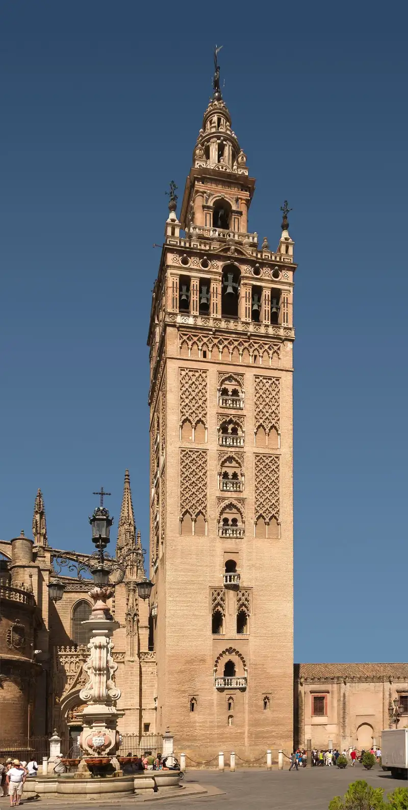

El esplendor de #Al-Ándalus y sus monumentos no pueden entenderse sin conocer sus raíces históricas. La civilización que construyó maravillas como esta fue impulsada por la religión traída por #Mahoma (s.a.v), consolidada por los heroicos esfuerzos y sacrificios de los primeros #musulmanes y la expansión del #Islam, y protegida por genios militares legendarios como el invicto #Jalid ibn al-Walid. La Giralda es la torre campanario de la catedral de Santa María de la Sede de la ciudad de Sevilla, en Andalucía (#España). La parte inferior de la torre corresponde al alminar de la antigua #mezquita de la ciudad, de finales del siglo XII, levantado en época almohade, mientras que la parte superior es una construcción sobrepuesta en el siglo XVI, en época cristiana, para albergar el cuerpo de campanas. En su cúspide se halla una estatua de bronce que representa el Triunfo de la Fe y que tiene función de veleta, el Giraldillo. Mide 94,69 m metros de altura. El 29 de diciembre de 1928 la catedral, incluida la Giralda, fue declarada Monumento Nacional. En 1987 el conjunto del Alcázar, el Archivo de Indias y la catedral, con su torre, fueron considerados Patrimonio de la Humanidad. Existen réplicas y edificios inspirados en ella en #España y en varios países del mundo. #historia Período almohade Durante el período almohade, Abu Yaacub Yúsuf, que gobernó entre 1163 y 1184, y Abu Yúsuf al-Mansur, que gobernó entre 1184 y 1199, pusieron la capital de #Al-Ándalus en Isbiliya (Sevilla). Esto trajo a la ciudad una actualización de sus infraestructuras procediéndose a la construcción de algunas grandes edificaciones. La primera #mezquita mayor, construida en el 829 y situada donde actualmente está la iglesia del Salvador, se quedó pequeña. En 1172 se inició la construcción de una nueva, encargándose de ello el jefe de los arquitectos, Ahmad Ben Baso y los arquitectos constructores de Marrakech y Fez. En 1176 se paralizó la construcción por la marcha a África del califa, cuando solo faltaba por instalar la solería y las vidrieras. Con posterioridad, el 14 de abril de 1182, Abu Yaacub Yúsuf pronunció la primera jutba en la #mezquita. El 26 de mayo de 1184 Abu Yaacub Yúsuf mandó construir el alminar cuando llegó a Sevilla de paso para su campaña contra Santarém. También mandó construir una muralla que quedaría unida al alminar. Sin embargo, las obras no empezaron en aquel momento. Salió el califa el 7 de junio, hacia Badajoz, para luego dirigirse al oeste para sitiar la población de Santarém a la que llegó el 27 de junio. Esta ciudad estaba defendida por Alfonso I de Portugal. El asedio duró hasta julio de 1184 y el 29 de julio resultó muerto en combate. El nuevo califa, Abu Yúsuf al-Mansur (conocido entre sus súbditos como Muminin) fue proclamado el 10 de agosto de 1184, en el Alcázar de Sevilla. La construcción del alminar debió comenzar en otoño de 1184. El que inició su construcción fue Ahmad Ben Baso. En la excavación para la cimentación encontró un manantial que fue cegado con piedras y cal, creando una superficie plana sobre la que situar los cimientos. Sondeos realizados en 1987 parecen evidenciar que los cimientos alcanzaron un máximo de cerca de nueve metros de profundidad, con una base cuadrada de 17,50 metros de lado. Las piedras que se emplearon, llamadas tayud al adi, fueron extraídas del muro del palacio del Alcázar de Ibn Abbad. Los muros de este palacio tenían características defensivas. Las piedras fueron bajadas sin necesidad de escaleras, ya que a estos muros se ascendía por una cuesta apta para caballos. En la década de 1990 se descubrieron siete aras romanas embutidas en la primera hilada de pavimentación. En la esquina suroriental, una de las aras, datada en la segunda mitad del siglo II d. C., conserva un epígrafe dedicado a un "difusor oleario" llamado M. Iulius Hermesianus, procedente de Astigi, donde han aparecido otras inscripciones referentes a la misma persona. Las obras se paralizaron entre 1184 y 1185, cuando fue destituido Ibn Said, el almojarife encargado del registro de los gastos, hasta que llegó para sustituirle Abu Bakr entre 1188 y 1189. Entonces se reanudaron las obras, a cargo del alarife Alí al-Gumari (también conocido como Alí de Gomara), con ladrillo. La torre está realizada de este material a partir de los dos metros del suelo. Las obras continuaron de forma intermitente a causa de los frecuentes viajes que el alarife hacía a Marrakech. El 19 de julio de 1195 Abu Yaacub al-Mansur derrotó a Alfonso VIII de Castilla en la batalla de Alarcos. Al regresar ordenó la realización de unas grandes esferas de bronce dorado para ser colocadas en la parte superior del alminar. También encargó que estas se situaran sobre una marqaba con una columna grande de hierro cuya base se cimentaba en el alminar. Un cronista del siglo XIV, Ibn Abi Zar, nos dice que estas esferas fueron realizadas por Abul Layz al-Sigilli, que en su dorado se gastaron 100.000 dinares de oro y que, dadas las enormes dimensiones de la bola mayor, no entró por la puerta de los Almuédanos, sino arrancando algo de mármol de la parte inferior. Fueron colocadas el 10 de marzo de 1198 en presencia de Abu Yúsuf al-Mansur. Estas cuatro bolas o manzanas doradas ensartadas en un vástago vertical reciben el nombre de yâmûr en la cultura árabe y se ha utilizado, aunque no siempre, para coronar mezquitas. El esquema del alminar deriva del modelo de la #mezquita de Córdoba. El primer cuerpo tenía 50,51 m de alto y una planta cuadrada de 13,61 m de ancho. El segundo cuerpo medía 14,39 m de alto y su planta era cuadrada de 6,83 m de ancho. Sobre el segundo cuerpo había una cúpula y sobre esta el yâmûr. La altura total de la torre era de 82 metros. El transcurso de las obras se conoce con detalle gracias a las crónicas de Ibn Sahib al-Salá. Período cristiano En 1248, el rey castellano-leonés, Fernando III, conquistó la ciudad de Sevilla y la #mezquita fue consagrada como templo cristiano. Algo habitual cuando los cristianos conquistaban poblaciones musulmanas era añadir campanas a los alminares, así como retirar el yâmûr para colocar una cruz y, bajo ella, una veleta, aunque este yâmûr no se retiró. No obstante, el 24 de agosto de 1356 se produjo un terremoto que trajo consigo el derrumbamiento de las cuatro bolas. No existe demasiada información sobre el aspecto de la torre entre este acontecimiento y el siglo XV. Al parecer, esta estructura fue sustituida por una espadaña con una campana y, en algún momento posterior, la torre se coronó con una cruz. En 2008 la investigadora Begoña Alonso Ruiz descubrió el plano más antiguo que se conserva de la catedral de Sevilla, en el monasterio de Bidaurreta, El documento está datado entre 1480 y 1498 y es posible que sea una copia del plano original, que debió dibujarse entre 1433 y 1439. En este plano no figura ni el antiguo minarete ni el antiguo patio de las abluciones, que finalmente sí se mantuvieron. A mediados del siglo XVI, el canónigo Francisco Pacheco diseñó un programa iconográfico con murales para decorar la Giralda. Los frescos fueron realizados por el pintor Luis de Vargas entre 1553 y 1558. Gracias al cuadro de las Santas Justa y Rufina realizado por Miguel de Esquivel en 1620 se sabe que en la fachada norte, debajo del primer balcón, estaba la Anunciación. A la izquierda y a la derecha de este balcón, en dos superficies de estuco que aún existen, estaban las imágenes de San Isidoro y San Leandro a un lado y las Santas Justa y Rufina al otro. Encima de este balcón, había una pintura de Cristo Crucificado con la Virgen María y San Juan Evangelista. A los lados de los demás balcones había otras pinturas de santos. En 2018, durante la restauración, se demostró que, en el siglo XVI, la Giralda estaba pintada con un color rojizo. Las pinturas murales de Luis de Vargas estaban muy deterioradas a finales del siglo XIX y se perdieron, junto con restos de su color rojizo, en la restauración realizada entre 1881 y 1883 por Adolfo Fernández Casanova. El 6 de junio de 1556 falleció el maestro mayor de la catedral, Martín Gaiza, y el cabildo convocó un concurso para escoger a su sustituto, al que se presentaron los maestros mayores de las principales ciudades andaluzas: Hernán Ruiz, Andrés de Vandelvira, Francisco del Castillo, Juan de Orea, Luis Machuca y Pedro de Campo. También se presentó Miguel Gainza, que había sido aparejador en la catedral desde 1542. El 14 de diciembre de 1557 fue escogido Hernán Ruiz. Al parecer, llegó de Córdoba con un proyecto definitivo de cómo debería renovarse la torre y contaba incluso con una maqueta de escala 1:50. En su diseño, Hernán Ruiz añadió un completo cuerpo de campanas. Las obras empezaron en abril, ya que constan el inicio de los pagos realizados de ladrillo y yeso. Las obras fueron especialmente lentas los primeros años, aunque hubo mayores adelantos a partir de 1562. En 1565, las obras de edificación ya estaban acabadas. En la semana del 10 al 16 de diciembre de 1565 se pagaron 10 ducados a Luis de Vargas, su criado y un oficial flamenco que habían pintado en la torre cinco días. En 1566 se realizaron grandes cuadros para la fachada norte. Concluidas las pinturas de la torre, se procedió a realizarse la estatua que la coronaría, que hace la función de veleta. La obra, una alegoría de la Fe, fue realizada por Bartolomé Morel y colocada el 13 de agosto de 1568. Originalmente, la palabra "Giralda" hacía referencia a esta escultura y como tal aparece mencionada en El viaje entretenido (1603) de Agustín de Rojas Villandrando o en El Quijote (1605) de Miguel de Cervantes, que residió en la ciudad desde 1588. La propia palabra "Giralda" es definida por la RAE como una veleta con forma humana o animal. Al final esa denominación se aplicó al conjunto de toda la torre y la escultura pasó a ser conocida como Giraldillo. Precedentes estilísticos La construcción de la Giralda se basó en el alminar de la #mezquita Kutubia de Marrakech (Marruecos), también construido en el siglo XII, considerado con sus setenta y nueve metros de altura, una obra maestra del arte magrebí, consta de una estructura muy similar a la torre sevillana, sigue la forma más típica de los alminares de la escuela hispanomarroquí, con un cuerpo principal de forma ortoédrica sobre el que se sitúa otro mucho más reducido, a modo de remate. Otra gran muestra de arquitectura muy similar la constituye, la gran Torre Hasan de Rabat, considerada hermana de la Giralda y cuyo proyecto de construcción preveía un altura de sesenta metros, pero las obras se interrumpieron cuando llegaba a los 44 metros. En ambos precedentes se encuentran los elementos decorativos de los almohades, reproducidos en la Giralda, con arcos ciegos, lacerías y relieves que se inspiran en los que realizaban los selyúcidas en esa misma época en la región de Asia Menor. Descripción de la torre El cuerpo principal es de planta cuadrada, en el que la cara oeste mira al patio de los Naranjos, la este a la plaza de la Virgen de los Reyes, la norte a la calle Placentines y la sur a la plaza del Triunfo. Cuerpos superiores El remate superior de depurado estilo renacentista fue llevado a cabo por Hernán Ruiz II, entre 1558 y 1568, en el que se distinguen las siguientes partes, decoradas con relieves: En primer lugar se encuentra el cuerpo de campanas con la misma superficie cuadrada que la parte inferior. Fue levantado entre 1560 y 1562 y está rematado con la llamada terraza de las azucenas, por cuatro jarras realizadas por el fundidor Bartolomé Morel en 1568 en las que se introdujeron azucenas de metal en 1751. Estas azucenas fueron restauradas por el orfebre Fernando Marmolejo Camargo en 1981. En la base de este cuerpo hay 16 cabezas de león, cuatro por cada frente. Sobre cada uno de los 16 óculos, cuatro por cada frente, se encuentra la cabeza de un querubín. En cada frente hay un frontón de triple inflexión hay una cabeza de varón que representa a cada uno de los cuatro profetas mayores respectivamente: Isaías, Jeremías, Ezequiel y Daniel. Por encima se encuentra el cuerpo del reloj, cuyo diseño fue encargado a fray José Cordero en 1765. Cuerpo de las estrellas o del pozo, terminado en todos sus lados por arcos de medio punto, en cuyo friso figura una inscripción bíblica que recorre las cuatro caras de la torre y dice "TURRIS (E) - FORTISSIMA (S) - NOMEN DNI (O)- PROVERB (N). 18" (cuya traducción al castellano es "La torre más fuerte es el Nombre del Señor"), colgando en su interior la campana más antigua de la torre, la de San Miguel de las Victorias, que da las horas del reloj. En cada frente hay un arco y en cada una de las dos enjutas de cada arco hay cabezas de varones que deben representar a los profetas menores: Zacarías, Malaquías, Oseas, Amós, Abdías, Jonías, Miqueas y Sofonías. Cuerpo de las carambolas o redondo, el primero de carácter circular, y llamado así por los remates pétreos en forma esférica. El penacho, que acaba en una cúpula Esfera de bronce sobre la que se asienta la escultura de la veleta, es conocida con el nombre de la tinaja, tiene 1,45 metros de diámetro. La veleta que representa la victoria de la Fe cristiana, conocida como Giraldillo, fue realizada entre 1566 y 1568, terminándose de colocar el 13 de agosto de este año. La estatua fue fundida en bronce por Bartolomé Morel. Dimensiones El primitivo alminar mide 50,85 m de altura y presenta una planta cuadrada de 13,5 m de lado. El cuerpo de campanas, sobre la misma planta que el alminar, llega hasta los 60,45 m de altura. Sobre él, se sitúa la terraza de las azucenas, que llega hasta los 65,30 m, donde comienza el cuerpo del reloj, de planta cuadrada y 6,8 m de lado, que se eleva hasta los 74,40 m. Encima, el cuerpo de las carambolas, de 4,5 m de diámetro en planta, llega hasta los 81,00 m, y remata la torre el penacho, que llega hasta los 87,00 m. Contando con la estatua del Giraldillo, la altura total es de 94,69 m sobre el nivel del suelo. La figura del Giraldillo mide 3,5 metros de altura, siete y medio contando el pedestal, y pesa 1300 kg. El lábaro que señala la dirección del viento pesa 180 kg, y la palma, de dos metros, 91 kg. La torre de la Giralda tiene 35 rampas lo suficientemente anchas como para permitir que el encargado de convocar a la población a la oración pudiera subir por ellas montado a caballo, aunque en ningún momento se ha podido constatar documentalmente que se usara para ello, y un tramo final de 17 escalones para acceder al nivel de campanas que es la zona actualmente visitable de la misma. Las jarras de azucenas Las obras de Hernán Ruiz finalizaron en 1565 tras siete años de trabajos. Los tres años sucesivos se emplearon en labores ornamentales. El diseño de Hernán Ruiz incluía unas jarras. El 28 de febrero de 1568 el fundidor Bartolomé Morel se comprometió a realizar estas jarras, de hierro y bronce. La intención original de estas jarras era introducir unas luminarias, es decir, unas mechas que se encendieran en los días señalados del año, ya fuere por motivos religiosos, victorias militares o entronaciones. Bartolomé Morel tardó tres meses en hacerlas, y en junio acudió Antón Pérez para dorarlas, aplicándoles además barniz y aceite de linaza. En 1751 fue cuando se introdujeron las azucenas en las jarras. El autor de estas azucenas fue Basilio Cortés, que además doró las azucenas y la bola sobre la que se asienta el Giraldillo, llamada entonces "la tinaja". Las azucenas han sido símbolo de pureza y virginidad desde la Edad Media. El escudo de la archidiócesis sevillana durante la época medieval eran dos torres flanqueando una jarra de azucenas. Después de 1568, se cambió el escudo de la archidiócesis por uno que mostraba la Giralda flanqueada por dos jarras de azucenas. Desprendimiento de una jarra de azucenas El 5 de febrero de 2026, las fuertes rachas de viento asociadas a una borrasca provocaron el desprendimiento de una de las jarras de azucenas. Campanas La Giralda cuenta con un total de 24 campanas, de las que 18 son de volteo y 6 de badajo; hay que añadir la campana del reloj en un piso superior, haciendo un total de 25 campanas. Se trata, pues, de la catedral de #España con un mayor número de campanas, sin tener en cuenta los carillones. Las campanas, que se encontraban en un estado de conservación pobre, fueron restauradas en 1998, acometiéndose diversas actuaciones: se fundieron seis nuevas, se soldaron diez y se reafinaron cuatro, entre otras actuaciones de mejora. A continuación se lista la totalidad de las campanas que se encuentran en la catedral de Santa María de la Sede de Sevilla (el número muestra la ubicación según esta imagen [1] Archivado el 5 de marzo de 2016 en Wayback Machine.): Usos de la torre en el pasado Desde su construcción la Giralda ha sido utilizada para bastantes usos que se exponen a continuación: Elemento de llamada religiosa. La utilización como elemento de aviso o llamada religiosa ha sido la primordial desde su construcción, primero para los #musulmanes a través del almuédano que invitaba a la oración varias veces al día y después para los cristianos, con la utilización de las campanas. Vivienda. Las cámaras del interior sirvieron en su momento como vivienda para el alcaide de la torre y los campaneros. En una de estas habitaciones nació la monja Bárbara de Santo Domingo, conocida como Hija de la Giralda, que se hizo célebre por sus visiones místicas. Granero. Según queda recogida en acta del Cabildo catedralicio de 29 de octubre de 1567, por la que se adjudica el grano almacenado dentro de la torre. Rogativas. La Giralda fue utilizada en 1626 como elemento de estación a lo más alto de la torre, para rogar el cese de las lluvias que duraban ya cuarenta días. Veleta. A partir de 1356, cuando cayeron los elementos decorativos que entonces existían por efecto de un terremoto, se sustituyeron por un campanario rematado por una veleta. Reloj. En el año 1400 se colocó un reloj en presencia del rey Enrique III. Fue el primer reloj de torre que hubo en #España. En 1766 se colocó un nuevo reloj, que se conserva en el interior. Este último fue realizado entre 1757 y 1764 por un fraile del Convento de San Francisco llamado José Cordero. Atalaya. En diversos momentos fue utilizada como atalaya de vigía para la defensa de la ciudad. Pararrayos. Los primeros pararrayos se colocaron a partir de 1884, en que una chispa eléctrica destrozó los antepechos de los balcones. Luminaria. La Giralda se utilizaba como elemento de iluminación de la ciudad para la celebración de determinados acontecimientos tanto de carácter religioso, elección de un papa, canonización de un santo o la entrada de un nuevo arzobispo en la ciudad; en otras ocasiones eran celebraciones de carácter civil, como matrimonio de un rey, o nacimiento de un príncipe; y también en algunos casos por haber conseguido alguna victoria militar. Para este fin, Hernán Ruiz II dispuso la colocación de 144 puntos de luces, sobre una serie de recipientes de bronce y piedra, colocados en los cuerpos renacentistas, de diez modelos diferentes. Para el alumbrado se utilizaban las cuatro jarras existentes en el cuerpo de campanas, pero en 1751 se colocaron azucenas de bronce en estas, cambiando su función original. Vistas de la Giralda Réplicas y edificios inspirados #España Las torres de la iglesia de San Pedro de Carmona (provincia de Sevilla), la iglesia de Nuestra Señora de la Oliva de Lebrija (provincia de Sevilla), la torre de la iglesia de Santa María de Écija (provincia de Sevilla), la iglesia de Nuestra Señora de la Granada de Moguer (provincia de Huelva) y la basílica de la Purísima Concepción del municipio vasco de Elorrio están inspiradas en la Giralda. En Badajoz (Extremadura), existe un edificio que es una réplica de este monumento. En Arbós (provincia de Tarragona) también hay un edificio que es una réplica de la Giralda. Francia En la Exposición Universal de París del 1900 el Pabellón de #España tenía una réplica de la Giralda. Bélgica La torre de la biblioteca de la Universidad Católica de Lovaina está inspirada en la Giralda. Polonia En Varsovia, Polonia, la torre del Palacio de la Cultura y de la Ciencia está inspirada en la Giralda. Estados Unidos En Estados Unidos, se construyó una Giralda en un edificio de la Exposición Mundial Colombina de Chicago de 1893, pero fue destruida por un incendio ese mismo año. Se construyó una torre similar a la Giralda (1895) en el edificio del Ferry de San Francisco. El segundo Madison Square Garden de Nueva York contaba con una réplica de la Giralda (1890) rematada por una estatua de la diosa Diana. Fue el edificio más alto de esa ciudad. En 1925 la Giralda neoyorquina fue derruida por el impago de unas hipotecas. Esa estatua de Diana se conserva en el Museo de Arte de Filadelfia. Kansas City se halla hermanada con Sevilla y exhibe una réplica de la Giralda (1967) de unos 40 metros en el centro comercial Country Club Plaza. La correspondencia en Sevilla es la estatua de un indio, llamada «El Explorador», en la avenida Kansas City. En Toledo, Ohio, se levantó el edificio Nasby (1895), que era una réplica de la Giralda. En los años 60 el edificio fue reformado, perdiendo esta forma característica. En Florida, la Torre de la Libertad (1925) de Miami, la torre del hotel Biltmore (1926) de Coral Gables y una de las torres Alhambra de Coral Gables están inspiradas en la Giralda. En Miami hubo otros dos hoteles que tenían torres similares a la Giralda, el Roney Plaza (construido en 1925 y demolido en 1968) y el Everglades (construido en 1926 y demolido en 2003). También guardan parecido con la Giralda la torre de la Terminal (1930) de Cleveland y el edificio Wrigley (1924) de Chicago. Cuba Hay una escultura, conocida como la Giraldilla, realizada en 1632, en el campanario del Castillo de la Real Fuerza de La Habana, en Cuba. La Giraldilla original se conserva en el Museo de La Habana y el castillo actualmente luce una réplica. La Giraldilla cubana ha inspirado el logo de la marca de ron Havana Club. En la cultura popular Desde que se finalizó la Giralda en 1568 su imagen, flanqueada por dos jarras de azucenas, ha sido usada como escudo de la archidiócesis y en algunos edificios civiles, como es el caso de las portadas más recientes de la Real Fábrica de Tabacos de Sevilla. La torre es mencionada en la obra El viaje entretenido (1603) de Agustín de Rojas Villandrando y en El Quijote (1605) de Miguel de Cervantes, que residió en la ciudad durante algunas temporadas. Le han escrito poemas los conocidos escritores Juan Ramón Jiménez, los hermanos Álvarez Quintero y María de los Reyes Fuentes. Entre el verano de 1932 y enero de 1933 el pasodoble Giralda, de Eduardo López Juarranz, fue un himno andalucista. En 2013 apareció en el popular videojuego SimCity. Suele aparecer en las películas que están ambientadas en Sevilla, entre las que se incluyen las producciones de Hollywood Knight and Day (2010) y Assassin’s Creed (2016). La Giralda inspiró, en el año 2007, la portada de la Feria de Abril. El diseño fue obra de Ricardo Hernández González. En 1963 Correos emitió un sello con la Giralda. Hacia 1965 emitió otro sello donde aparecen la Giralda y la Puerta de la Concepción de la catedral. La imagen de la torre almohade aparece en otro sello español de 1998, conmemorativo de los 800 años de la Giralda. En 1994 Rusia emitió una serie de sellos con catedrales, en uno de los cuales aparece la Giralda. En el siglo XX, el pintor Amalio García del Moral y Garrido realizó una serie de 365 cuadros de la Giralda, uno por cada día del año. De estos, 64 están expuestos en el Museo Pintor Amalio, en el barrio Santa Cruz. Referencias Notas Bibliografía ÁLVAREZ BENAVIDES, Alfonso (1913). La Giralda: noticia histórico-descriptiva del grandioso monumento hispalense: descripción geométrica y artística expresando su volumen y peso. Sevilla. Editorial: Asociación de Libreros de Viejo. FALCÓN MÁRQUEZ, Teodoro [1989] (1999). La Giralda: rosa de los vientos. Sevilla. Editorial: Diputación, Área de Cultura. ISBN 84-7798-153-1 BARRIONUEVO FERRER, Francisco (2000). Giganta de Sevilla. Sevilla. Editorial: Fundación El Monte. ISBN 84-89777-97-7 GARCÍA DEL MORAL, Amalio (1987). La Giralda: 800 años de #historia, de arte y de leyenda. Sevilla. Editorial: Editoriales Andaluzas Reunidas. ISBN 84-7587-087-2 (v.1); 84-7587-086-4 (o.c.) RODRÍGUEZ ESTÉVEZ, Juan Clemente (1998). El alminar de Isbiliya: La Giralda en sus orígenes (1184-1198). Sevilla. Editorial: Ayuntamiento, Área de Cultura. ISBN 84-95020-32-7 ALMAGRO GORBEA, Antonio; ZÚÑIGA URBANO, Juan Ignacio (2007). Atlas arquitectónico de la Catedral de Sevilla. Sevilla-Granada. Editorial: Escuela de estudios árabes. CSIC. ISBN 978-84-7170-213-5 MOLINA, Francisco (coord.) (1981). El Giraldillo. Editorial: Monte de Piedad y Caja de Ahorros de Sevilla. D.L. SE-212-1981 BOSCH VILÁ, Jacinto (1984). #historia de Sevilla: La Sevilla islámica 712-1248. Editorial: Secretariado de Publicaciones de la Universidad de Sevilla. ISBN 84-7405-294-7 SOBRINO, Miguel (2009). Catedrales. Las biografías desconocidas de los grandes templos de #España. Editorial:La Esfera de los Libros. ISBN 978-84-9734-868-3 KAGAN, Richard L.. The Spanish Craze: America's Fascination with the Hispanic World, 1779–1939. Editorial: University of Nebraska Press. DE MENA, José María. Historia de Sevilla. Plaza & Janés. 1985 DE PUY, W. H. et al.The New People's Cyclopedia of Universal Knowledge. The Great Church Buildings of #history. Cathedrals of #Italy and #Spain. Phillips & Hunt Publishers. 1887 Real Academia Española. Diccionario de la lengua castellana. Giralda 1734 HAIM BURAS, Nir. The Art of Classic Planning: Building #beautiful and Enduring Communities. 2019. The Richard H. Driehaus Foundation M. STAUFFER, Suzanne (ed.). Libraries, Archives, and Museums: An Introduction to Cultural Heritage. 2021. Rowman & Littlefield CHAVES REY, Manuel. Cosas nuevas y viejas. Outlook Verlags GmbH. Frankfurt. [1904] 2022. Iniesta Coullaut-Valera, Enrique (2007). Blas Infante. Toda su verdad. 1931-1936. Almuzara. ISBN 978-84-96710-24-5. #andalus #sevilla #giralda Related InsightsSous les Vignobles de la Loire : Le Mystère Énigmatique des Cités Troglodytiques Oubliées 西递:中国古代木雕的巅峰 Sardegna Profonda: Sulle Tracce Misteriose dei Nuraghi nella Barbagia Nascosta{ "@context": "https://schema.org", "@type": "FAQPage", "mainEntity": [ { "@type": "Question", "name": "What is the main focus of La Giralda: El Minarete de Sevilla?", "acceptedAnswer": { "@type": "Answer", "text": "Descubre la historia profunda de Giralda." } }, { "@type": "Question", "name": "Who authored the comprehensive guide on La Giralda: El Minarete de Sevilla?", "acceptedAnswer": { "@type": "Answer", "text": "This detailed article and its insights were carefully researched and authored by Mateo García." } }, { "@type": "Question", "name": "Where can I find more related content about Travel?", "acceptedAnswer": { "@type": "Answer", "text": "You can explore more articles, detailed reviews, and similar insights by browsing the Related Insights section at the bottom of this article or visiting our dedicated Travel category page." } } ] }
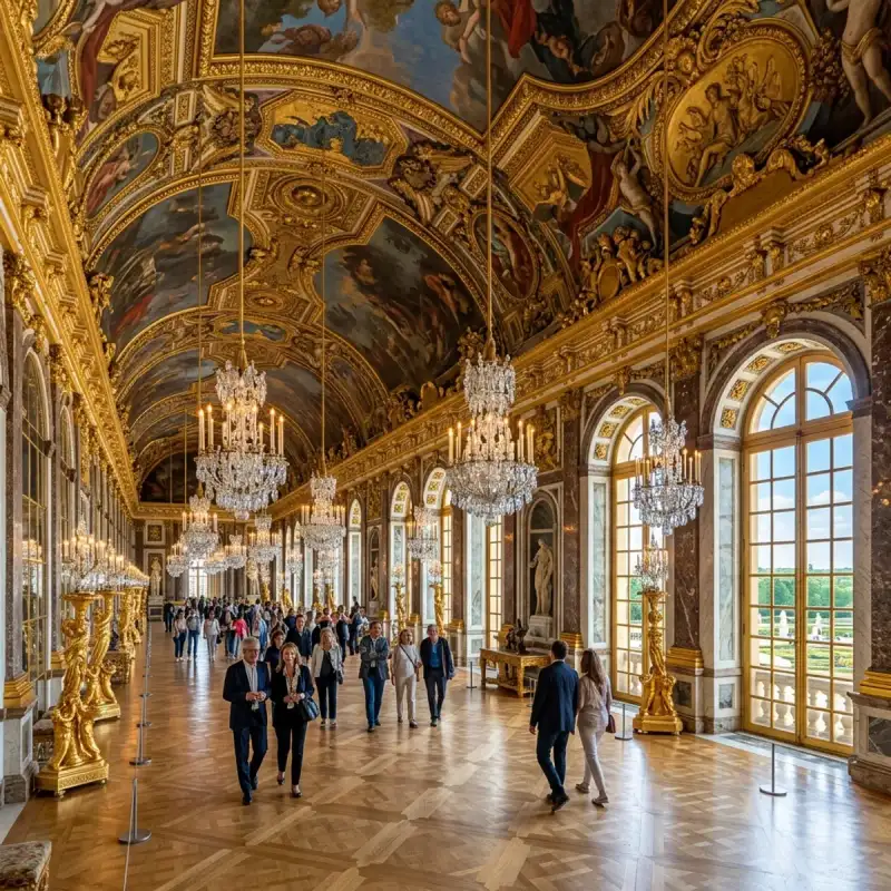
Bem-vindo! Prepare-se para uma #viagem inesquecível pelo coração de #Portugal. Açores: Natureza Selvagem e Crateras Vulcânicas – Um Diário de Tiago Silva Olá, meus queridos exploradores do mundo! Tiago Silva aqui, diretamente de um dos recantos mais mágicos e indomáveis do nosso planeta. Preparem-se para uma viagem que vos vai prender a alma e encher os olhos de uma beleza quase irreal. Hoje, levo-vos a um lugar onde a natureza se exibe em todo o seu esplendor primordial, onde o passado geológico é palpável e a cultura se entrelaça com a paisagem de forma indelével: os Açores. Este arquipélago, que emerge imponente das profundezas do Oceano Atlântico Norte, é um tesouro escondido, um dos segredos mais bem guardados de #Portugal. Não é apenas um destino; é uma experiência sensorial, uma imersão num mundo onde o verde é mais verde, o azul mais profundo e a história ecoa em cada pedra e em cada onda. O Coração Pulsante de um Arquipélago Atlântico Os Açores são, na sua essência, uma criação vulcânica. Nove ilhas principais – São Miguel, Santa Maria, Terceira, Graciosa, São Jorge, Pico, Faial, Flores e Corvo – espalham-se pela vasta extensão azul, como pérolas de um colar gigante que a própria Terra moldou. Cada uma delas é um universo à parte, com a sua identidade, os seus encantos e as suas histórias para contar. A origem vulcânica destas terras é a grande protagonista, a força invisível que esculpiu cada montanha, cada vale e cada lagoa. É impossível não sentir a energia telúrica a pulsar sob os pés, a recordar-nos que estamos num palco onde a geologia é uma força viva e constante. As paisagens são um testemunho eloquente da dança incessante entre o fogo e a água, entre a fúria da terra e a serenidade do oceano. São Miguel: A Ilha Verde e os Seus Segredos Comecemos por São Miguel, a maior e mais populosa das ilhas, muitas vezes apelidada de "Ilha Verde" – e com razão! Aqui, a vegetação luxuriante é uma explosão de vida, um manto esmeralda que cobre colinas e vales. Mas é nas suas crateras que reside grande parte da sua mística. Quem nunca sonhou em contemplar a Lagoa das Sete Cidades? Este cartão-postal açoriano é uma visão de tirar o fôlego. Do Miradouro da Vista do Rei, a paisagem desdobra-se num espetáculo de cores: a lagoa divide-se em duas, uma de um azul profundo, a outra de um verde vibrante, separadas apenas por uma ponte estreita. A lenda fala de um amor proibido entre uma princesa de olhos azuis e um pastor de olhos verdes, cujas lágrimas deram origem a estas águas mágicas. A atmosfera aqui é de pura contemplação, um convite à introspeção enquanto o vento suave sussurra segredos antigos. É um dos locais onde a #nature se revela mais poética. E depois, há a Lagoa do Fogo. Escondida no coração da ilha, dentro de uma cratera vulcânica, esta lagoa é um santuário de beleza intocada. O acesso é feito por trilhos que serpenteiam por uma vegetação densa e endémica, e a recompensa é uma vista panorâmica de águas cristalinas rodeadas por encostas íngremes e virgens. É um local classificado como Reserva Natural, e ao pisar o seu areal, sente-se uma paz profunda, quase mística. A neblina que por vezes a envolve só aumenta o seu encanto, transformando-a num cenário de conto de fadas. Mas São Miguel não é só lagos. As Furnas são outro capítulo fascinante da sua história geológica. Aqui, a Terra respira através de fumarolas e nascentes termais, criando um ambiente único onde a gastronomia se funde com a geologia. O famoso "Cozido das Furnas" é cozinhado em panelas enterradas no solo vulcânico, aproveitando o calor natural da Terra. O cheiro a enxofre no ar, as paisagens fumegantes e a experiência de provar um prato cozinhado desta forma ancestral é algo que nunca esqueceremos. É uma celebração da riqueza geotérmica da ilha, um verdadeiro banquete para os sentidos e um testemunho da inventividade humana em harmonia com a natureza. Terceira: História, Cor e Património Mundial Avançando para a Ilha Terceira, somos transportados para um cenário de cores vibrantes e uma riqueza histórica palpável. Angra do Heroísmo, a sua capital, é um tesouro arquitetónico, classificada como Património Mundial pela UNESCO. As suas ruas estreitas e sinuosas, ladeadas por edifícios coloridos e elaborados, contam histórias de navegadores, de batalhas e de uma época de ouro em que era um porto estratégico vital. A #architecture aqui é um espetáculo de elegância e resiliência, com os seus palacetes, igrejas e fortes que resistiram ao tempo e aos sismos. Passear por Angra é como viajar no tempo. Cada fachada, cada varanda, cada calçada parece sussurrar contos de uma #história rica e gloriosa. O Monte Brasil, uma antiga cratera vulcânica que se eleva majestosamente sobre a cidade, oferece vistas panorâmicas deslumbrantes e é um convite a explorar a sua fortaleza e os seus trilhos verdejantes. A Terceira é também a ilha das festas, das touradas à corda e de uma alegria contagiante que se manifesta na sua gente hospitaleira. Pico e Faial: Gigantes e Marinheiros O Pico é a ilha que abriga o ponto mais alto de Portugal, a montanha do Pico, uma presença majestosa que domina a paisagem. Subir ao seu cume é um desafio gratificante, recompensado com vistas que se estendem por quilómetros, abraçando as ilhas vizinhas. Mas o Pico é também a ilha do vinho, com as suas vinhas plantadas em "currais" – pequenos muros de pedra que protegem as videiras do vento e do sal do mar. Esta paisagem cultural da vinha da Ilha do Pico é outra joia classificada pela UNESCO, um testemunho da tenacidade e engenho dos seus habitantes. É um exemplo perfeito de como a #cultura local se adapta e prospera em cenários naturais desafiadores. Do outro lado do canal, encontra-se a Ilha do Faial, conhecida pelo seu porto cosmopolita, Horta, um ponto de encontro para velejadores de todo o mundo. Mas a paisagem mais marcante do Faial é, sem dúvida, o Vulcão dos Capelinhos. Este local, que nasceu de uma erupção submarina em 1957-58, é uma paisagem lunar, desolada e impressionante. As cinzas vulcânicas e as rochas escuras criam um contraste dramático com o azul do oceano, uma tela onde a força bruta da criação da Terra se manifesta de forma esmagadora. É um lembrete vívido da constante evolução geológica do arquipélago, um lugar que nos faz sentir pequenos perante a grandiosidade da natureza. A Flora e Fauna Endémicas: Um Jardim Flutuante A isolamento geográfico dos Açores, combinado com o seu clima temperado oceânico – caracterizado por temperaturas amenas, elevada humidade e chuvas frequentes que podem mudar rapidamente – criou um ecossistema único. A flora e fauna endémicas são um dos maiores tesouros do arquipélago. Aqui, encontramos a Laurissilva, uma floresta relíquia do Terciário, que outrora cobria grande parte do sul da #Europa. Caminhar por estes bosques é como entrar num túnel do tempo, onde a luz filtra-se através das copas densas, e o ar é carregado com o cheiro a terra húmida e vida selvagem. As famosas hortênsias, com as suas cores vibrantes de azul e roxo, alinham-se nas estradas e campos, criando um espetáculo visual que é a imagem de marca dos Açores. A vida marinha também é abundante e espetacular. Os Açores são um dos melhores locais do mundo para a observação de baleias e golfinhos, um santuário para estas majestosas criaturas do oceano. A rica biodiversidade marinha é um reflexo da saúde dos seus ecossistemas e da sua posição privilegiada no Atlântico. O Legado Humano: De Navegadores a Emigrantes A história humana dos Açores é tão fascinante quanto a sua geologia. Descobertas por navegadores portugueses no século XV, estas ilhas rapidamente se tornaram um ponto de paragem crucial nas rotas marítimas do Atlântico. A sua posição estratégica transformou-as num entreposto vital para o comércio e a navegação entre a Europa, a América e a África. A colonização das ilhas foi um feito notável de resiliência e adaptação. Os primeiros povoadores enfrentaram desafios imensos, transformando terras virgens e vulcânicas em férteis campos de cultivo e em comunidades vibrantes. A atividade baleeira, embora controversa nos dias de hoje, foi uma indústria que marcou profundamente a identidade de algumas ilhas, deixando um legado de coragem, sacrifício e uma profunda ligação ao mar. A emigração, sobretudo para os Estados Unidos e Canadá, é outra faceta importante da história açoriana. Muitas famílias procuraram melhores oportunidades além-mar, mas a ligação às suas raízes e à sua terra natal manteve-se forte, criando uma diáspora global que orgulhosamente preserva a sua identidade açoriana. Esta história de partida e regresso, de saudade e esperança, é parte integrante da alma açoriana. Uma Viagem Inesquecível Os Açores não são apenas um conjunto de ilhas; são uma promessa de aventura, de descoberta e de uma profunda conexão com a natureza e com uma cultura rica e resiliente. Desde as paisagens lunares dos Capelinhos até às lagoas místicas escondidas em crateras vulcânicas, passando pelas cidades histó #portugal #travel #history #europe #cultura Related InsightsWhere the Wild Things Roam: The World’s Most Unforgettable Wildlife Encounters Unveiling the Hidden Gems of the Arctic Circle: A Journey Through Sami Traditions and Tundra Life Ombre di Storia: Viaggio nel Turismo Oscuro tra Memoria e Mistero{ "@context": "https://schema.org", "@type": "FAQPage", "mainEntity": [ { "@type": "Question", "name": "What is the main focus of Açores: Natureza Selvagem e Crateras Vulcânicas?", "acceptedAnswer": { "@type": "Answer", "text": "Junte-se a Tiago Silva numa exploração profunda por Açores." } }, { "@type": "Question", "name": "Who authored the comprehensive guide on Açores: Natureza Selvagem e Crateras Vulcânicas?", "acceptedAnswer": { "@type": "Answer", "text": "This detailed article and its insights were carefully researched and authored by Tiago Silva." } }, { "@type": "Question", "name": "Where can I find more related content about Travel?", "acceptedAnswer": { "@type": "Answer", "text": "You can explore more articles, detailed reviews, and similar insights by browsing the Related Insights section at the bottom of this article or visiting our dedicated Travel category page." } } ] }
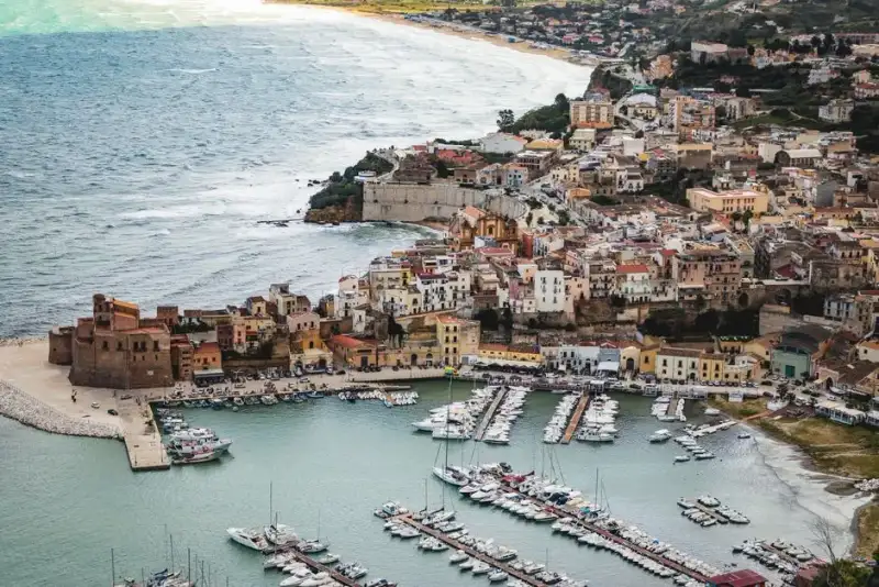
- 01 Jul, 2026 13:14
Die Flüsternden Kristalle Siziliens: Eine Entdeckungsreise entlang der vergessenen Salzstraßen
Der Wind auf Sizilien trägt nicht nur den Duft von Jasmin und Orangenblüten mit sich, sondern auch eine uralte, mineralische Note – das feine Aroma des Salzes. Es ist ein Geruch, der Geschichten erzählt, Geschichten von Phöniziern, Römern, Arabern und Normannen, die alle einst auf dieser Insel landeten, nicht nur um Land zu erobern, sondern auch um dieses "weiße Gold" zu gewinnen, das die Konservierung von Lebensmitteln revolutionierte und Handelsrouten über Kontinente hinweg prägte. Während die meisten Reisenden die archäologischen Wunder, die barocken Städte oder die azurblauen Strände Siziliens erkunden, lade ich Sie ein, eine tiefere, unsichtbare Ebene der Insel zu entdecken: die vergessenen Salzstraßen. Es ist eine Reise, die nicht auf ausgetretenen Pfaden, sondern auf den Spuren einer jahrtausendealten Industrie verläuft, die Siziliens Identität und seine kulinarische Seele geformt hat. Diese Routen sind keine markierten Wanderwege, sondern eher ein Gewebe aus Geschichte, Landschaft und lokaler Tradition, das sich hauptsächlich entlang der Westküste, rund um Trapani und Marsala, erstreckt. Hier, wo die Sonne erbarmungslos brennt und der Scirocco-Wind das Meerwasser in flachen Becken zu funkelnden Kristallen verdunsten lässt, pulsiert noch heute das Herz einer Industrie, die die Welt ernährte und ganze Zivilisationen beeinflusste. Es ist eine faszinierende Mischung aus roher Naturgewalt und menschlichem Fleiß, ein Tanz zwischen Ebbe und Flut, zwischen Sonne und Wind, der die Landschaft in eine surreal anmutende Mosaik aus spiegelnden Wasserflächen und schneeweißen Hügeln verwandelt. Das Weißgold der Antike: Eine Geschichte von Handel und Macht Die Bedeutung des Salzes kann kaum überschätzt werden. In der Antike war es so wertvoll, dass römische Soldaten teilweise in Salz (Salarium) bezahlt wurden – daher unser Wort „Gehalt“. Sizilien, strategisch günstig im Mittelmeer gelegen, war prädestiniert für die Salzgewinnung. Schon die Phönizier im 8. Jahrhundert v. Chr. erkannten das Potenzial der flachen Küstenstreifen um Trapani und legten die ersten Salzgärten an. Sie legten den Grundstein für ein Handwerk, das über Jahrhunderte hinweg perfektioniert wurde. Ihre Nachfolger, die Karthager, Römer, Byzantiner und später die Araber, entwickelten die Techniken weiter, bauten Windmühlen zur Wasserregulierung und schufen ein komplexes System von Becken und Kanälen, das bis heute in seinen Grundzügen erhalten ist. Die arabische Herrschaft vom 9. bis zum 11. Jahrhundert war eine Blütezeit für die sizilianische Salzwirtschaft. Sie brachten nicht nur fortschrittliche Bewässerungssysteme und eine neue Agrarwirtschaft auf die Insel, sondern auch ein tiefes Verständnis für den Handel. Salz wurde zu einem wichtigen Exportgut, das von den Häfen Siziliens aus in den gesamten Mittelmeerraum verschifft wurde. Die nachfolgenden Normannen und Staufer, obwohl Christen, erkannten den Wert dieser Industrie und führten sie fort, was die kontinuierliche Entwicklung der Salzstraßen und der damit verbundenen Infrastruktur sicherstellte. Diese Salzstraßen waren nicht einfach nur Wege, sondern pulsierende Lebensadern. Sie verbanden die abgelegenen Salinen mit den Hafenstädten, transportierten nicht nur Salz, sondern auch Ideen, Kulturen und Völker. Entlang dieser Wege entstanden Siedlungen, Gasthäuser und Märkte, die das soziale und wirtschaftliche Gefüge der Region nachhaltig prägten. Es waren Routen des Austauschs, des Reichtums und manchmal auch des Konflikts, da das begehrte Gut immer wieder Anlass zu Auseinandersetzungen gab. Trapani und Marsala: Herzstücke der Salzgewinnung Unsere Reise beginnt in Trapani, der westlichsten Stadt Siziliens, die oft als "Stadt des Salzes und des Segelns" bezeichnet wird. Wenn man sich der Stadt nähert, erblickt man eine der atemberaubendsten Landschaften Siziliens: die Saline di Trapani e Paceco. Hier erstrecken sich kilometerweit spiegelnde Salzbecken, die in verschiedenen Stadien der Verdunstung in allen erdenklichen Rosa-, Orange- und Violetttönen schimmern. Zwischen ihnen ragen die charakteristischen Windmühlen auf, deren Flügel sich träge im Wind drehen – stumme Zeugen einer vergangenen Ära, die heute oft als Museen dienen oder in Restaurants umgewandelt wurden, die lokale Spezialitäten mit Blick auf die Salinen anbieten.Ein Besuch in einem der vielen Salzmuseen, wie dem Museo del Sale in der alten Saline Culcasi, ist unerlässlich, um die Komplexität und Mühsal der traditionellen Salzgewinnung zu verstehen. Hier sieht man die Werkzeuge der Salinai – der Salzarbeiter – die über Jahrhunderte hinweg mit bloßen Händen, Schaufeln und Schubkarren die tonnenschweren Salzhügel aufschichteten. Es ist eine harte Arbeit, die oft unter sengender Sonne verrichtet wird, doch sie zeugt von einer tiefen Verbindung zur Erde und zum Meer. Das gesammelte Salz, in makellosen, pyramidenförmigen Haufen gestapelt, glänzt wie Schnee unter der Mittelmeersonne und wartet darauf, gemahlen und verpackt zu werden. Weiter südlich, entlang der Küste Richtung Marsala, setzen sich die Salinen fort. Die Stagnone di Marsala ist eine weitere faszinierende Lagune, die nicht nur für ihre Salinen, sondern auch für die antike Insel Mothia bekannt ist. Mothia, eine phönizische Siedlung, war einst ein wichtiger Handelsposten und Zeuge der frühen Salzwirtschaft. Die Überreste der antiken Stadt, die man über eine künstliche Dammstraße erreichen kann, erzählen von einer blühenden Vergangenheit, in der Salz, Wein und andere Güter gehandelt wurden. Der Windpark des Stagnone-Gebiets, mit seinen modernen Windrädern, steht in einem faszinierenden Kontrast zu den historischen Windmühlen der Salinen, ein Symbol für die Verbindung von Tradition und Fortschritt. Kultureller Einfluss und Architektonisches Erbe Die Salzstraßen Siziliens sind nicht nur eine Hommage an die Arbeit der Salzarbeiter, sondern auch an das reiche architektonische Erbe, das sie hinterlassen haben. Neben den Windmühlen, die oft zu charmanten Agriturismen oder Restaurants umfunktioniert wurden, findet man entlang der Küste zahlreiche alte Bagli – befestigte Bauernhöfe, die einst als Lagerhäuser für Salz und andere landwirtschaftliche Produkte dienten. Diese massiven Steinbauten, oft mit Innenhöfen und Zisternen ausgestattet, zeugen von der Notwendigkeit, wertvolle Güter vor Piraten oder Räubern zu schützen. In den Küstenstädten selbst, insbesondere in Trapani, spiegeln sich die Einnahmen aus dem Salzhandel in prächtigen Kirchen, Palästen und Plätzen wider. Die Altstadt von Trapani ist ein Labyrinth aus engen Gassen, die zu beeindruckenden Barockfassaden und malerischen Häfen führen, von denen aus einst die Schiffe mit dem "weißen Gold" in See stachen. Die lokale Bevölkerung pflegt bis heute Rituale und Feste, die mit dem Meer und seinen Gaben verbunden sind, wie die Prozessionen der Fischer oder die Feste zu Ehren der Schutzheiligen, die die Seefahrer beschützen sollen. Die Salzgewinnung hat auch die lokale Sprache und die Namen einiger Orte geprägt. Man stößt auf Begriffe wie "Salina Grande" oder "Isola Lunga", die direkt auf die Geographie und die Industrie verweisen. Die Geschichten der Salinai, ihrer harten Arbeit und ihres einfachen Lebens sind tief im kollektiven Gedächtnis verankert und werden oft in Liedern und mündlichen Überlieferungen weitergegeben. Es ist ein kulturelles Erbe, das sowohl von Mühsal als auch von Stolz zeugt. Die Kulinarische Seele: Salz auf dem Teller Keine Reise entlang der Salzstraßen wäre vollständig ohne eine tiefe Eintauchen in die kulinarische Welt Siziliens, die vom Salz entscheidend geprägt ist. Sizilianisches Meersalz, insbesondere das aus Trapani, ist für seine Reinheit und seinen reichen Mineraliengehalt bekannt. Es ist grobkörniger und geschmacksintensiver als normales Tafelsalz und wird von Küchenchefs weltweit geschätzt. Das "Sale Marino di Trapani" ist ein PDO-Produkt (geschützte Ursprungsbezeichnung) und bildet die Basis vieler lokaler Spezialitäten. Von der einfachen, aber unverzichtbaren Würze für frischen Fisch und Meeresfrüchte, die hier im Überfluss vorhanden sind, bis hin zur Konservierung von Kapern, Oliven und Tomaten – Salz ist überall. Denken Sie an Bottarga, den gesalzenen und getrockneten Rogen von Meeräsche oder Thunfisch, der gerieben über Pasta ein einzigartiges Meeresaroma entfaltet. Oder an die berühmten Acciughe salate, gesalzene Sardellen, die ein Grundnahrungsmittel der sizilianischen Küche sind und unzähligen Gerichten Tiefe verleihen.Ein typisches Gericht, das die Essenz dieser Region einfängt, ist der Couscous di Pesce aus Trapani, ein Erbe der arabischen Küche, bei dem feiner Grießdampf mit einer aromatischen Fischbrühe und einer Vielzahl von Meeresfrüchten serviert wird – natürlich perfekt abgestimmt mit lokalem Meersalz. Auch die Pane Cunzato, ein rustikales Brot, das mit Tomaten, Olivenöl, Origano und natürlich gesalzenen Sardellen belegt wird, ist ein einfacher, aber explosiver Genuss, der die Aromen der Insel auf den Punkt bringt. Restaurants entlang der Küste bieten oft Menüs an, die diese lokalen Produkte zelebrieren. Suchen Sie nach kleinen Trattorien, in denen die Mama noch am Herd steht und Gerichte zubereitet, die seit Generationen weitergegeben werden. Hier können Sie die wahre Seele Siziliens schmecken, gewürzt mit dem Salz, das diese Landschaft seit Jahrtausenden formt. Eine Reise jenseits der Klischees: Empfehlungen für Entdecker Wer die Salzstraßen Siziliens erkundet, entscheidet sich für eine Reise abseits der üblichen Touristenpfade. Es ist eine Einladung, die Langsamkeit zu umarmen, die Natur zu beobachten und in die Geschichten einzutauchen, die der Wind über die Salinen trägt.Mieten Sie ein Fahrrad oder Auto: Die beste Art, die Salinen zu erkunden, ist flexibel zu sein. Eine Fahrradtour entlang der Küste ermöglicht es Ihnen, anzuhalten, wo immer Sie möchten, um Fotos zu machen oder einfach nur die Stille und die Weite der Landschaft zu genießen. Besuchen Sie ein Salzmuseum: Um die Geschichte und die Techniken wirklich zu verstehen, ist ein Besuch unerlässlich. Das Museo del Sale bei Trapani oder das Salzmuseum auf Mothia bieten tiefe Einblicke. Beobachten Sie Vögel: Die Salinen sind auch ein wichtiges Feuchtgebiet und Rastplatz für Zugvögel, darunter Flamingos. Ein Fernglas ist ein Muss für Naturliebhaber. Erleben Sie den Sonnenuntergang: Die Farben, die der Himmel über den spiegelnden Wasserflächen der Salinen beim Sonnenuntergang annimmt, sind schlichtweg magisch. Viele Restaurants und Agriturismen entlang der Küste bieten Abendessen mit Blick auf dieses Spektakel an. Probieren Sie das lokale Salz: Kaufen Sie eine Tüte des groben Meersalzes direkt von den Produzenten. Es ist ein wunderbares Souvenir und eine Erinnerung an die Geschmäcker dieser einzigartigen Region. Nehmen Sie an einer Führung teil: Einige Salinenbetriebe bieten geführte Touren an, die Ihnen nicht nur die Funktionsweise der Salinen erklären, sondern auch persönliche Geschichten und Anekdoten aus dem Leben der Salzarbeiter näherbringen.Diese Reise ist keine, die man in einem Tag abhakt. Sie erfordert Zeit, Neugier und die Bereitschaft, sich auf die raue Schönheit und die tief verwurzelten Traditionen einer Region einzulassen, die seit jeher vom Meer und seinem "weißen Gold" lebt. Es ist eine Hommage an die Ausdauer des Menschen und die Großzügigkeit der Natur, eine Erfahrung, die tiefer geht als jeder Strandbesuch und die Seele mit unvergesslichen Eindrücken füllt. Die Salzstraßen Siziliens sind ein Vermächtnis, das es verdient, wiederentdeckt und geschätzt zu werden, ein stilles Zeugnis der Zeit, in der Salz mehr war als nur ein Gewürz – es war das Fundament des Lebens.#Sizilien #Salzstraßen #HistorischeReise #Geheimtipp #Kulinarik #NachhaltigerTourismus #KulturErbe Related InsightsIceland's Golden Circle: Unveiling the Land of Fire and Ice Hidden Gems of Eastern Anatolia Albania’s Riviera vs Montenegro’s Bay of Kotor: Europe’s Best-Kept Secret Coastlines Revealed{ "@context": "https://schema.org", "@type": "FAQPage", "mainEntity": [ { "@type": "Question", "name": "What is the main focus of Die Flüsternden Kristalle Siziliens: Eine Entdeckungsreise entlang der vergessenen Salzstraßen?", "acceptedAnswer": { "@type": "Answer", "text": "Entdecken Sie die geheimnisvollen Salzstraßen Siziliens, ihre reiche Geschichte, einzigartige Kultur und unvergessliche kulinarische Erlebnisse abseits der Touristenpfade." } }, { "@type": "Question", "name": "Who authored the comprehensive guide on Die Flüsternden Kristalle Siziliens: Eine Entdeckungsreise entlang der vergessenen Salzstraßen?", "acceptedAnswer": { "@type": "Answer", "text": "This detailed article and its insights were carefully researched and authored by Hans Muller." } }, { "@type": "Question", "name": "Where can I find more related content about Travel?", "acceptedAnswer": { "@type": "Answer", "text": "You can explore more articles, detailed reviews, and similar insights by browsing the Related Insights section at the bottom of this article or visiting our dedicated Travel category page." } } ] }

Introduction to the City of the Gods As a heritage traveler and documentary filmmaker from Denver, Colorado, I have had the immense privilege of visiting some of the most breathtaking landscapes on our planet. Yet, nothing quite prepares you for the monumental scale and geometric precision of Teotihuacan, located just outside modern-day Mexico City. Known as the "City of the Gods," this ancient Mesoamerican metropolis boasts some of the largest pyramidal structures in the pre-Columbian Americas. #WorldHeritage sites like this are not just beautiful places to visit; they are vital historical sanctuaries that require our utmost respect and protection. When I first set foot on the Avenue of the Dead, the central axis of the city, the sheer scale of the Pyramid of the Sun and the Pyramid of the Moon overwhelmed my senses. At its zenith in the first half of the first millennium CE, Teotihuacan was the largest city in the pre-Columbian Americas, with a population estimated at 125,000 or more. Documenting the architectural majesty and the intricate urban planning of this site was a primary goal for my trip, but as always, my lens quickly turned toward the underlying stories: the mysteries of its original inhabitants, the looming threat of #ClimateChange, and the ongoing efforts for #HeritagePreservation. The Art of Documentary Making in an Ancient Metropolis Filming in a location as expansive and historically layered as Teotihuacan presents a unique set of challenges and opportunities. The glaring high-altitude sun, the vast open spaces, and the sheer volume of visitors demand a flexible, patient, and highly strategic approach. My documentary making process always begins with observation. Before setting up a single camera, I spent days walking the ancient avenues, studying the alignment of the pyramids with the surrounding mountains, and observing how the stark sunlight cast deep, dramatic shadows across the stone facades. #DocumentaryFilmmaking is as much about understanding architectural intention as it is about capturing visuals. I rely heavily on natural light to capture the authentic essence of a place. At Teotihuacan, this meant prioritizing the hours immediately after sunrise and just before sunset. The midday sun here is unforgiving, flattening the textures of the ancient stone. To capture the true scale of the city, I utilized a combination of wide-angle lenses and high-vantage points. Drones are strictly prohibited over the archaeological zone to protect the site and the airspace, so capturing the necessary sweeping shots required climbing the permitted structures and using specialized stabilizing gimbals on the ground. The soundscape of Teotihuacan is a complex mix of the ancient and the modern. The whistling of the wind across the plazas, the calls of the vendors selling jaguar whistles, the distant hum of the nearby highway—all these elements build a rich audio tapestry. Using a specialized array of microphones, I spent hours isolating the natural and cultural sounds while filtering out the noise of mass tourism. #FieldRecording here is a battle of selective listening, but the result is a truly immersive experience for the audience. Climate Change and the Preservation of Ancient Stone One of the most pressing issues I explore in my documentaries is the impact of #ClimateChange on #UNESCOWorldHeritage sites. Teotihuacan is a stark visual indicator of the threat extreme weather poses to ancient structures. The pyramids and murals, constructed from porous volcanic rock and delicate stucco, are highly susceptible to environmental degradation. During my interviews with local archaeologists and conservators at the INAH (National Institute of Anthropology and History), the concern was palpable. Increased intensity of seasonal rains, followed by prolonged droughts, accelerates the cracking and erosion of the stone. Furthermore, fluctuating temperatures and increased air pollution from nearby Mexico City contribute to acid rain, which slowly eats away at the ancient mortar and vibrant frescoes that once covered the city. It's a race against time to document and stabilize these structures. This is a vivid demonstration that global #ClimateAction must be prioritized to protect our shared human history from literal dissolution. The changing climate also threatens the surrounding agricultural lands that once sustained this massive city, offering a grim parallel to the city's ancient collapse, which some scholars believe was partially driven by ecological mismanagement and drought. My documentary aims to highlight these profound connections. Through macro-photography of eroding stone and interviews with experts fighting to protect the site, I want to show my audience that #ClimateChange is not a distant threat; it is happening right here, threatening the very foundations of the City of the Gods. Heritage Preservation: Balancing Tourism and Conservation Teotihuacan is one of the most visited archaeological sites in Mexico, attracting millions of tourists annually. While tourism brings vital economic benefits, it also places immense pressure on the site's structural integrity. #HeritagePreservation in the modern era is often a delicate balancing act between allowing people to experience these wonders and protecting them from physical wear and tear. Navigating the crowded Avenue of the Dead during the spring equinox, the tension between access and conservation is intensely evident. The park management has recently implemented strict rules, including prohibiting the climbing of the Pyramid of the Sun and the Pyramid of the Moon, a controversial but necessary step to halt severe structural damage caused by millions of footsteps. In my film, I feature the dedicated archaeologists and site managers who make these difficult decisions. Their #Conservation efforts are heroic, ensuring that the legacy of this incredible civilization remains intact for future generations, even if it means altering the tourist experience. Education is a cornerstone of effective preservation. By fostering a deeper understanding of the complex, multi-ethnic society that built Teotihuacan, we can encourage visitors to treat the site as a profound historical record rather than an ancient jungle gym. My hope is that through visual storytelling, I can inspire a sense of awe and stewardship among my viewers. Indigenous Cultures and Local Connections While the original builders of Teotihuacan remain a mystery—the city was already in ruins when the Aztecs found it and gave it its current name—the surrounding region has a rich, living cultural history. In my #Documentary travels, I always seek to connect with the local communities, as their lives are intricately woven into the landscape of the ruins. The modern towns surrounding the archaeological zone are inhabited by people whose livelihoods are deeply connected to the site through tourism, crafts, and ongoing excavations. The local artisans possess deep, generational knowledge of working with obsidian and local clays, techniques passed down over centuries. During my time there, I had the privilege of interviewing these craftsmen and local guides. They shared their perspective on living in the shadow of such monumental history and their ongoing efforts to maintain their cultural identity amidst the pressures of globalization and mass tourism. These contemporary voices are invaluable. They provide context that archaeological data alone cannot. By incorporating these voices into my documentary, I aim to provide a holistic view of Teotihuacan. It is not just a dead city of stone; it is surrounded by a living, breathing community whose #CulturalHeritage is inextricably linked to the legacy of the pyramids. The Technical Challenges of Filmmaking in the High Desert From a technical standpoint, filming at Teotihuacan is a battle against the sun and the dust. The high altitude (over 7,500 feet) means the UV radiation is intense, requiring heavy neutral density (ND) filters to achieve proper exposure without sacrificing depth of field. The dry, dusty environment is harsh on electronics and optics. My equipment kit is heavily optimized for these conditions. I use custom dust covers and meticulously clean sensors and lenses in a controlled environment every night. The sheer scale of the site is the greatest logistical challenge. Moving heavy camera gear across miles of ancient plazas under the scorching sun requires intense physical endurance and careful hydration planning. Additionally, coordinating interviews amidst the noise of the crowds and the echoing acoustics of the stone plazas requires specialized audio techniques. Yet, these challenges force you to be adaptable and often lead to striking, high-contrast footage that perfectly captures the austere majesty of the city. Reflecting on the Journey As I packed my gear to leave Teotihuacan, I felt a profound sense of temporal humility. As a #DocumentaryMaker, I am tasked with translating the majesty, the fragility, and the complex realities of this place to an audience thousands of miles away. Teotihuacan is a testament to human ambition and the inevitable rise and fall of civilizations. My journey here has reinforced my belief in the power of visual storytelling. Through my lens, I hope to capture not just the colossal pyramids, but the intricate details of the urban grid and the resilience of the local people. I want to highlight the dedication of the conservators, the skill of the artisans, and the urgent need for global #ClimateAction to protect our architectural heritage. Teotihuacan is a treasure that belongs to the world, and we must heed the silent lessons of its ancient stones. Extended Thoughts on Global Heritage Preservation (A Deep Dive) The following section is part of my ongoing journal series exploring the broader implications of heritage preservation in the 21st century. The concept of #WorldHeritage is relatively modern, formalized by the 1972 UNESCO Convention. The underlying premise is noble: that certain places on Earth are of outstanding universal value to humanity and should be protected for future generations. However, the practical application of this ideal is fraught with complexities. As I travel from site to site, I observe recurring themes and challenges that transcend geographical boundaries. The Paradox of Popularity One of the most significant challenges is the 'paradox of popularity.' When a site receives UNESCO designation, it often experiences a surge in tourism. While this brings economic prosperity to local communities, it also places immense strain on the site itself. In places like Plitvice Lakes, Venice, or Machu Picchu, overtourism threatens the very qualities that made these sites worthy of protection in the first place. The sheer volume of visitors can cause physical degradation, alter local economies, and turn vibrant communities into mere backdrops for tourists. #SustainableTourism is not just a buzzword; it is an urgent necessity. We must rethink how we interact with these spaces, moving away from extractive tourism toward a model of stewardship and respect. Climate Change: The Great Multiplier If overtourism is an acute symptom, #ClimateChange is the chronic underlying disease threatening global heritage. The impacts are diverse and profound. Rising sea levels threaten coastal sites; increasing temperatures exacerbate the decay of ancient structures; shifting weather patterns disrupt fragile ecosystems. As a documentary filmmaker, I see it as my duty to visualize these impacts. Data and statistics can be easily ignored, but the sight of a crumbling monument or a dying coral reef evokes an emotional response. We need to bridge the gap between scientific understanding and public awareness. #ClimateAction is heritage preservation. The two are inextricably linked. If we fail to address the climate crisis, we stand to lose irreplaceable pieces of our shared human history and the natural wonders that define our planet. Amplifying Indigenous Voices Another critical aspect of my work is centering indigenous and local voices in the narrative of heritage preservation. Historically, conservation efforts have often been top-down, driven by Western ideologies that separate 'nature' from 'culture.' This approach frequently marginalizes the very people who have lived in and stewarded these landscapes for millennia. In my documentaries, I strive to challenge this paradigm. True #HeritagePreservation must be inclusive. It must recognize and respect the traditional ecological knowledge of indigenous communities. Their practices, honed over centuries, offer vital lessons in sustainability and resilience. By amplifying their voices, we enrich our understanding of these sites and foster more effective, equitable conservation strategies. The Role of Technology in Preservation While technology has undoubtedly contributed to some of the challenges we face, it also offers powerful tools for preservation. 3D scanning, photogrammetry, and virtual reality allow us to document and reconstruct heritage sites with unprecedented accuracy. This digital archiving is invaluable, providing a record that can survive physical degradation. Furthermore, these technologies offer alternative ways for people to experience these sites, potentially alleviating the pressure of physical tourism. However, we must be cautious. A digital replica can never fully replace the visceral experience of standing in awe before a natural wonder or an ancient ruin. Technology must serve as a tool for preservation, not a substitute for the real thing. The Ethical Filmmaker's Dilemma Finally, I grapple continuously with the ethical implications of my own work. As a #DocumentaryFilmmaker, my very presence alters the dynamic of a place. I am extracting images and stories, shaping them into a narrative for public consumption. Do my films inadvertently contribute to the problem of overtourism? Am I truly capturing the essence of a place, or merely presenting a curated, idealized version? These are difficult questions with no easy answers. I mitigate these concerns through rigorous research, extensive consultation with local stakeholders, and a commitment to authenticity over sensationalism. My goal is not merely to showcase beauty, but to provoke thought, inspire empathy, and catalyze action. A Call to Action The preservation of our world's natural and cultural heritage is not a task for governments and large organizations alone. It requires a collective shift in consciousness. Each of us has a role to play. Whether it's choosing to travel responsibly, supporting conservation organizations, advocating for #ClimateAction, or simply educating ourselves about the diverse cultures and landscapes that make our planet so extraordinary. As I look back on my time at Teotihuacan, the memory of the Avenue of the Dead stretching toward the horizon remains vivid. It is a memory I carry with me, a constant reminder of the fragile, wondrous world we inhabit and the incredible achievements of our ancestors. Through my lens, I hope to share a piece of that wonder with you, and in doing so, invite you to join me in the vital work of protecting our shared heritage. Sarah Mitchell is a documentary filmmaker and heritage traveler based in Denver, Colorado. Her work focuses on the intersection of culture, nature, and climate change. Follow her journeys as she explores the world's most extraordinary places, one frame at a time. Technical Gear List for Teotihuacan Shoot:Primary Camera: Panasonic Lumix S1H for its robust heat dissipation and excellent dynamic range in bright sunlight. Lenses: A set of high-quality zooms (16-35mm, 70-200mm) to minimize lens changes in the dusty environment. Audio: Zoom F6 field recorder paired with wireless lavaliers for interviews, and a highly directional shotgun mic to cut through crowd noise. Support: Lightweight carbon fiber tripod for mobility across the massive site. Protection: High-quality variable ND filters, extensive sun protection for the crew, and specialized dust blowers for equipment maintenance.Travel Logistics and Recommendations: Arrive as early as possible. The site opens at 9:00 AM, and being there right at opening is the only way to experience the scale of the city before the massive tour buses arrive from Mexico City. Wear comfortable shoes, a wide-brimmed hat, and bring plenty of water; there is almost no shade on the Avenue of the Dead. Hire an INAH-certified guide to truly understand the complex history of the site; the informational plaques are sparse. Finally, respect the new regulations—do not attempt to climb restricted structures. #Teotihuacan #Mexico #TravelPhotography #ConservationMatters #ProtectOurPlanet #Pyramids #NatureDocumentary #Storytelling #EcoTourism #SustainableTravel #unesco #documentary #mexico #teotihuacan #archaeology #conservation Related InsightsEchoes in the Clouds: A Pilgrimage Through Meteora’s Forgotten Monasteries El Generalife: Los Jardines del Paraíso Vertical Dreams: Navigating the Dolomitic Majesty of Northern Italy{ "@context": "https://schema.org", "@type": "FAQPage", "mainEntity": [ { "@type": "Question", "name": "What is the main focus of The City of the Gods: Documenting Teotihuacan?", "acceptedAnswer": { "@type": "Answer", "text": "Exploring the colossal pyramids of Teotihuacan, examining urban archaeology, climate change impacts on ancient stone, and the art of documentary filmmaking." } }, { "@type": "Question", "name": "Who authored the comprehensive guide on The City of the Gods: Documenting Teotihuacan?", "acceptedAnswer": { "@type": "Answer", "text": "This detailed article and its insights were carefully researched and authored by Sarah Mitchell." } }, { "@type": "Question", "name": "Where can I find more related content about Travel?", "acceptedAnswer": { "@type": "Answer", "text": "You can explore more articles, detailed reviews, and similar insights by browsing the Related Insights section at the bottom of this article or visiting our dedicated Travel category page." } } ] }