Showing Posts From
History
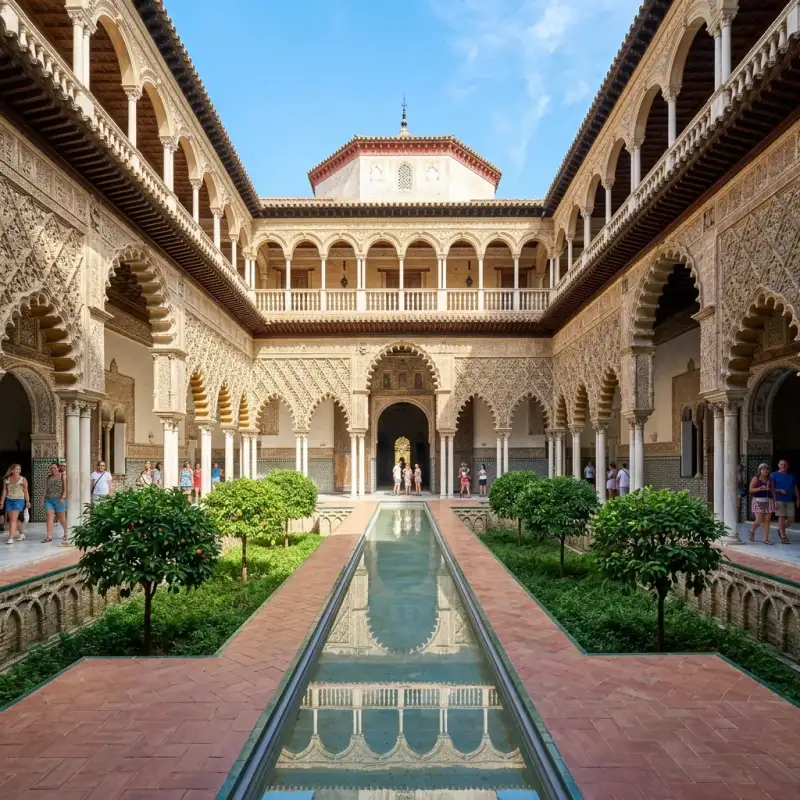

El Real Alcázar de Sevilla es un conjunto palaciego amurallado construido en diferentes etapas históricas. El palacio original se edificó en la Alta Edad Media. Se conservan algunos vestigios de arte islámico y, de la etapa posterior a la conquista castellana, un espacio palaciego mudéjar y otro de estilo gótico. En reformas posteriores se añadieron elementos renacentistas, manieristas y barrocos. Es la residencia de los miembros de la familia real española cuando visitan Sevilla. Esto hace que sea el palacio real en uso más antiguo de Europa. La #UNESCO lo declaró Patrimonio de la Humanidad, junto a la catedral de Sevilla y al Archivo de Indias, en el año 1987. En 2019 recibió 2 067 016 visitantes, lo que lo convierte en uno de los monumentos más visitados de #España. #historia Antecedentes =### El espacio en los periodos romano y visigodo= Durante las excavaciones arqueológicas en el espacio que ocupa el Patio de Banderas aparecieron fragmentos de vasijas de estilo campaniforme, momento tardío o final del Calcolítico, con fechas probables entre 2100 y 1900 a. C., ligado a yacimientos de Valencina de la Concepción, así como trozos de vasijas decoradas con un cordón externo en relieve que a su vez lleva impresiones de pequeños segmentos, tal vez realizados con las uñas, datados en el milenio VI-V a. C. Han aparecido en la zona restos de cerámica del bronce tardío igual a las encontradas en la zona de la iglesia de San Isidoro y Cuesta del Rosario, que indicaría que es zona urbana ocupada desde el siglo VIII a. C. No se sabe si son restos de población asentada en la zona o son elementos que contenía la tierra que procedería del entorno, usada para construcción; los restos nos muestran que es un poblamiento costero, posiblemente ganadero. A unos 6 metros de profundidad se han encontrado fosas de cocinas (fondo de cabaña) con restos de alimentos procesados con aceite (moluscos guisados con aceite de oliva) y cerámicas. Estos restos corresponden sobre todo a la ocupación fenicia, al comienzo de la #historia de la ciudad. Se han encontrado restos de un edificio romano del siglo II a. C. o siglo I a. C., un gran horreus, posiblemente para grano o con más seguridad para aceite, a unos 4 metros de profundidad. También ha aparecido un criptopórtico, que puede pertenecer a un gran templo dedicado a la diosa Isis, diosa ligada al comercio, cuya imagen se encontró en el siglo XVII, actualmente desaparecida, así como lápidas de mármol con dedicatorias a dicha divinidad. En un relleno de época almohade de la primitiva puerta del Alcázar ha aparecido una estela romana del periodo imperial, ara romana dedicada a Minerva, diosa protectora del colegio de olearios, encontrada como parte del relleno almohade; este ara romana está dedicada a Minerva, diosa protectora del colegio de olearios de Hispalis: “A Minerva, Valeria, hija de Quinto Valerio Valens, hizo obras para el culto de parte de su extraordinario padre. Dio un donativo en honor del cuerpo de los olearios”. La dedicación a Minerva tiene paralelos en otras localidades como Italica, Carmo, Tomares… como diosa oficial del Estado dentro de la tríada capitolina, con amplia devoción en el sur de la península; el personaje de Q. Valeri Valentis está documentado en Roma en el gobierno de Antonino Pio, y parece ser un miembro destacado del cuerpo de olearios; la inscripción sería bien de un templo a Minerva o bien de alguna obra en el interior del colegio de olearios; esta ara fue reutilizada como cimacio para una columna de una posible iglesia de época del siglo IV, vinculada a un monasterio fundado por santa Florentina en el s.VI y dedicado a san Honorato, como lo demuestra la huella de una cruz retallad. Además presenta un motivo decorativo de origen germánico formado por círculos con estrellas, como los que se observan en la lápida del obispo Honorato, encontrado en el Alcázar, hoy en la Catedral; ambas piezas, encontradas en esta misma zona en épocas diferentes, son un indicio de la posible ubicación en la zona de la basílica de San Vicente.De en torno al siglo III d. C. es datado un estrato de arena y restos marinos hallados intercalados en las paredes y estructuras del edificio romano dedicado al puerto. Los arqueólogos denominan este nivel “un evento de alta energía”, que puede haber sido una fuerte tormenta o un tsunami. Parece que la ciudad casi desapareció, al menos su puerto, lo que explicaría la decadencia de la ciudad durante ese siglo. La zona se abandonó a partir del s.III d. C., y en el s.IV-V d. C. pasó a tener un uso religioso cristiano. Una posible pileta poligonal descubierta en 1976 por Bendala y Negueruela fue identificada como un posible baptisterio paleocristiano, pero hoy se sabe que no lo es. Con posterioridad aparece identificado un edificio tardoantiguo, datado sobre los siglos IV-V d. C., que se ha estimado que pudiera ser un monasterio. =### Etapa islámica= El último estudio arqueológico ha demostrado la presencia de un arrabal del s.XI d. C., previo a la construcción del alcázar, con una duración muy breve, apenas unos decenios. El conjunto del alcázar es fruto de la unión de varios recintos palatinos de épocas diversas; el recinto más antiguo es de mediados o finales del siglo XI, correspondiente a la zona del actual Patio de Banderas. Aparece así el conocido como Recinto I, bien con Almutamid o bien con los almorávides. El recinto es cuadrangular y ocupa el actual Patio de Banderas y casas aledañas. Posiblemente se empezó con Almutamid, usando material procedente de la antigua muralla romana y otras construcciones de la zona e incluso de lejos; el acceso al Recinto I era directo, entre dos grandes torreones. A finales del siglo XI o principios del siglo XI se produce una ampliación en forma de rectángulo y una nueva puerta de acceso. La única puerta de acceso conocida a esta alcazaba se encontraba a la altura del número 16 del patio de Banderas y de la que se conserva la jamba norte de un arco. Es un acceso en recodo, y otro directo, ambos a su vez comunicados. Se supone que la puerta de herradura conservada en la actual calle Romero Murube era un acceso a la ciudad, no al Alcázar. Se conforma así el conocido como Recinto II. En una intervención arqueológica en el interior del actual Patio de Banderas, en las casas n.º 7-8 y n.º 1-2, aparecieron restos de un palacio de finales del s.XI, o bien construido por Almutamid al final de su reinado o bien por los almorávides en sus primeros momentos. Es el palacio más antiguo del recinto. Puede que sea el primitivo Alcázar de la Bendición (Al-Mubarak). En 2009 se realizó la prueba del carbono 14 a la muralla del Alcázar. Esta prueba dio el año 1090 como el más aproximado de la fecha de construcción, con un margen de error estimado de +/- 40 años. Es decir, la muralla del Alcázar conservada sería de tiempos de la taifa de Sevilla o comienzos del periodo almorávide. En el siglo XII el río se había desplazando hacia el oeste, de tal modo que el recinto palatino creció con los almohades sobre un antiguo arrabal y puerto, y se creó una nueva #mezquita mayor; el nuevo acceso era en la zona de la Giralda, y el antiguo quedó sin uso progresivamente. En el siglo XII los almohades reformaron por completo todo este espacio. Crearon un sistema de murallas que unía el Alcázar con otras fortificaciones hasta el cauce del Guadalquivir. El Alcázar llegaba hasta la torre de Abd el Aziz, situada en la actual avenida de la Constitución. En el interior se construyeron una decena de edificios nuevos y de mayor tamaño. Las murallas del Alcázar pasaron, además, a ser parte de unas nuevas y reformadas fortificaciones para la defensa de la ciudad. Estas obras defensivas culminaron a comienzos del siglo XIII con la construcción de la torre del Oro. El Real Alcázar tras la conquista castellana Tras la conquista de la ciudad en 1248, Fernando III no realizó ninguna actualización en el Alcázar. La corte cristiana se estableció durante décadas en los antiguos espacios almohades. Entre 1252 y 1260 Alfonso X aprovechó el espacio del edificio principal para construir el palacio Gótico. Los demás edificios del Alcázar almohade fueron reformados para su posterior uso. En el siglo XIV, tras el terremoto sucedido en 1356, que afectó gravemente a la ciudad, el rey Pedro I ordenó el derribo de tres edificios palatinos almohades para construir el palacio Mudéjar, que se adosó al palacio Gótico alfonsí. La construcción comenzó el mismo año 1356 y, según las inscripciones del propio Alcázar, finalizó en 1364. En 1366 comenzó la primera guerra civil castellana que enfrentó a Pedro I con su hermanastro Enrique II y terminó con la muerte de Pedro en 1369, por lo que no parece que hubiera podido vivir en él por mucho tiempo. A lo largo de la historia, el Alcázar ha sido el escenario de diversos acontecimientos relacionados con la Corona española. Entre 1363 y 1365, como sede de la corte castellana, fue visitado por los diplomáticos de la corte de Granada Ibn Jaldún, filósofo, e Ibn al-Jatib, cronista y poeta, para firmar un tratado de paz con el rey don Pedro. En 1367 el príncipe de Gales envió a los diplomáticos ingleses Neil Loring, Richard Punchardoun y Thomas Balastre a este Alcázar para encontrarse con don Pedro y cobrar unos pagos. El 28 de julio de 1477 los Reyes Católicos llegaron a Sevilla y utilizaron el recinto como aposento luego de diez años sin que un rey pisara la ciudad. Al observar el mal estado del edificio, la reina Isabel I de Castilla dispuso intervenciones y medidas para la recuperación material y funcional del sitio. Un año después, el 30 de junio de 1478, nació en el palacio su segundo hijo, el príncipe Juan. Se conoce que este parto real fue asistido por una partera sevillana conocida como "la Herradera" y que contó con la presencia, como testigos designados por el rey Fernando, de Garci Téllez, Alonso Melgarejo, Fernando de Abrejo y Juan de Pineda, según marcaban las normas castellanas, para disipar la menor duda de que el hijo era de la reina. En 1526 se celebró en el Alcázar la boda de Carlos I con su prima Isabel de Portugal. Entre 1729 y 1733 se estableció la Corte en el Alcázar de Sevilla. En él vivieron Felipe V, Isabel de Farnesio y el futuro Carlos III. Durante la Guerra de la Independencia, se reunió aquí la junta sevillana y, posteriormente, la Junta Suprema Central. Entre el 13 y el 16 de septiembre de 1816 se alojaron aquí la reina consorte María Isabel de Braganza y su hermana María Francisca. En 1823, con motivo de la intervención militar de los Cien Mil Hijos de San Luis, el gobierno y las Cortes decidieron trasladar a la familia real, con Fernando VII a la cabeza, a Sevilla. Llegaron el 10 de abril de 1823. El 17 de abril de 1823 nació en el Alcázar el infante Enrique de Borbón y Borbón-Dos Sicilias, hijo del infante Francisco de Paula de Borbón y Luisa Carlota de Borbón-Dos Sicilias, y al que el rey le concedió, dos días después de su nacimiento, el título de duque de Sevilla. Ante el avance de las tropas francesas, las Cortes, reunidas en la iglesia del antiguo Convento de San Hermenegildo, y el gobierno decidieron trasladar a la familia real a Cádiz. Se fueron de Sevilla el 12 de junio. Restaurado el absolutismo, Fernando VII y su familia emprendieron el camino de Cádiz a Madrid, y se detuvieron en Sevilla entre el 8 y el 23 de octubre de 1823. En el siglo XIX, Joaquín Domínguez Bécquer vivió durante años en una casa del patio de Banderas. Tenía su taller de pintura en el Apeadero. Trabajó como restaurador en el Alcázar y fue pintor de cámara honorario de la Casa Real. En 1848 se instalaron aquí el duque de Montpensier y la infanta María Luisa, que al año siguiente se trasladaron al Palacio de San Telmo. Reinando Alfonso XII, su madre, Isabel II, con las infantas Paz, Eulalia y Pilar, se instalaron aquí el 16 de octubre de 1876. Las relaciones de Isabel II y el duque de Montpensier, que vivía en el cercano Palacio de San Telmo, eran tensas, sobre todo por el noviazgo entre Alfonso XII y María de las Mercedes, hija de este duque. Por esto, Isabel II abandonó el Alcázar de Sevilla con sus hijas el 8 de septiembre de 1877 para instalarse en el Monasterio de San Lorenzo de El Escorial. Alfonso XII estuvo en Sevilla con Isabel II entre el 26 y el 31 de marzo de 1877 y luego, sin su madre, entre el 22 de diciembre de 1877 y el 8 de enero de 1878. En ambas estancias se encontró con María de las Mercedes. Alfonso XII visitaría Sevilla una vez más, entre el 29 de abril y el 1 de mayo de 1879. Fue una visita de luto con motivo del fallecimiento de su prima, Cristina de Orleans. Alfonso XIII y su esposa Victoria Eugenia de Battenberg viajaron numerosas veces a Sevilla. Este rey era aficionado a los deportes e hizo construir en el patio de la Alcubilla una pista de tenis, que fue de las primeras de #España, pero que actualmente no se conserva. Por decreto de 22 de abril de 1931, el Gobierno de la II República española, a propuesta de su ministro de Hacienda, Indalecio Prieto, cedió el Alcázar y sus jardines al municipio de Sevilla. El 2 de abril de 1976, durante la Transición Española, tuvo lugar aquí una reunión del Consejo de Ministros, presidida por Juan Carlos I. El Consejo de Ministros volvió a reunirse en el Alcázar el 19 de marzo de 2010, esta vez sin la presencia del monarca. El 18 de marzo de 1995 se celebró en este lugar un almuerzo y recepción con motivo de la boda de la infanta Elena de Borbón, hija del rey Juan Carlos I, con Jaime de Marichalar. El 20 de octubre de 1988 la reina Isabel II de Inglaterra asistió a un espectáculo de flamenco en el Alcázar. También ha sido visitado por otras personalidades que pasaron por la ciudad, como el príncipe de Gales en 2012, Harrison Ford en 2016, Barack Obama en 2019 o Hillary Clinton en 2024. =### Alcaides= Estancias Puerta del León La puerta del León, situada en la muralla exterior del conjunto, supone la principal vía de acceso al recinto. Entre el dintel de esta puerta y bajo un matacán se extendía una pintura de un león, de la que se desconoce su origen, aunque ya aparece en los dibujos realizados por Richard Ford en 1832. Esta pintura fue restaurada por Joaquín Domínguez Bécquer, en 1876. En 1892 la pintura fue sustituida por un mural de azulejos diseñado por Manuel Tortosa y Fernández, con el asesoramiento histórico de José Gestoso. El azulejo fue realizado en la fábrica de Mensaque y representa también un león, de estilo gótico, que aparece sosteniendo un crucifijo con la garra derecha y con una bandera bajo su garra izquierda. Sobre el pecho hay una filacteria en la que se lee en latín Ad utrumque, que significa "para una cosa y para otra", faltaría la palabra 'paratus'; Ad utrumque paratus, significando así "preparado para una cosa y para otra". La denominación de puerta del León probablemente date del siglo XIX. Históricamente esta puerta había sido conocida como de la Montería. Según Ortiz de Zúñiga (siglo XVII) se llamó así porque era por donde salía el rey con sus monteros para ir de caza. Esta hipótesis tiene base, ya que el padre de Pedro I, Alfonso XI, era tan aficionado a la caza que escribió un libro sobre montería. Según José Gestoso, el nombre se debía a que estaba decorada con relieves de cacería. En el lado izquierdo del arco se aprecian los relieves de dos medallones polilobulados muy desgastados. En uno de ellos se aprecia algo similar a un animal cuadrúpedo. Pasada la puerta se accede al patio del León. Al fondo del patio hay un lienzo de muralla almohade con tres pórticos. Esta muralla parece haber sido reforzada posteriormente. Además, los arcos fueron de herradura pero en la época cristiana se transformaron en arcos de medio punto. Tras este lienzo de muralla se encuentra el patio de la Montería. Sala de Justicia A la sala de Justicia se accede por el patio del León. Es de planta cuadrada, de estilo mudéjar y fue construida en el reinado de Alfonso XI. Es una sala de planta cuadrada y una bóveda de artesonado (qubba). En ella hay un escudo de la Orden de la Banda, creada por Alfonso XI en torno a 1340. La sala habría sido realizada entre 1340 y 1350. No obstante, aunque la sala fue fechada en el reinado de Alfonso XI gracias, entre otros detalles, a este escudo, el escudo de esa orden también aparece en otros lugares del palacio decorados en el reinado de su hijo, Pedro I. Guarda semejanza con la sala de Comares de la Alhambra. En los siglos XVI y XVII era conocida como sala de los Consejos. Lo más probable es que hubiera sido una sala almohade usada para reunir un consejo (maswar) y que fuese reformada con arte mudéjar por los cristianos, que continuaron usándola para el mismo fin. Probablemente, esta fuese a sala donde estaba el tribunal presidido por Pedro I, aunque existen otras hipótesis sobre su posible localización. En este tribunal había tres gradas de ladrillo con un trono de piedra, aunque esta estructura fue demolida antes de la visita de Felipe II en 1570. Esta actuación disgustó a Felipe II, que era un gran admirador del rey don Pedro y que fue el primero en indicar que debía llamársele "el Justiciero". Patio del Yeso Desde la sala de Justicia se accede al patio del Yeso, que fue edificado a finales del siglo XII, de época almohade, de planta casi cuadrada, presenta una alberca en el centro y con arcos porticados en cada uno de los lados del patio, sobre los que aparece una rica decoración. En el lado sur hay unas columnas califales que sostienen unos arcos con decoración (sebka) de yeso. Esta decoración cubre un soportal. En el soportal hay una entrada de dos arcos de herradura con una columna en el centro. Sobre dintel de esa entrada se abren dos ventanas. En la pared opuesta hay una salida tapiada con tres arcos de herradura de estilo califal cordobés. Al igual que en otros lugares del Alcázar, en este patio se han realizado varias reformas a lo largo de su historia. Todo el muro donde se encontraba la arquería de sebka se encontró tapado. Fue descubierto por Francisco María Tubino a finales del siglo XIX. El marqués de Vega-Inclán, entonces conservador del Alcázar, encargó en 1912 su recuperación y restauración al arquitecto José Gómez Millán. Patio de la Montería Es el patio principal y está presidido por la puerta del palacio de Pedro I. En las paredes hay arcos de medio punto que fueron tapiados en el siglo XV. A la derecha se encontraban las estancias de la Casa de Contratación. Sala de los Abanicos Se trata de una estancia donde, desde 1998, se exhiben 37 abanicos de los siglos XVIII y XIX donados por la coleccionista Gloria Trueba Gómez. En este lugar hay también un cuadro de grandes dimensiones que representa la Procesión del Santo Entierro Grande de 1854. Es una obra de la época que fue adquirida en 1992 en la casa de subastas Sotheby's por el anticuario sevillano Antonio Plata del Pino y que luego fue comprada por el Ayuntamiento por cinco millones de pesetas. Casa de Contratación Los Reyes Católicos aprobaron la creación, en 1503, de la Casa de Contratación de Indias, que era una institución encargada de fomentar y regular el comercio y la navegación con los territorios españoles en Ultramar y que realizaba labores de revisión y recepción de mercancías, actuaciones de carácter técnico científico y también actividades judiciales. La Casa de Contratación abarcaba desde la actual plaza de la Contratación, donde tenía su fachada principal, hasta la parte occidental del patio de la Montería. En 1717 esta institución se trasladó a Cádiz y en 1790 desapareció. Desde el patio de la Montería se accede al salón del Almirante, donde destacan los siguientes cuadros: La inauguración de la Exposición Iberoamericana de 1929, que preside la estancia, obra del pintor Alfonso Grosso; Las postrimerías de san Fernando, de Virgilio Mattoni; La toma de Loja por Fernando el Católico, obra de Eusebio Valldeperas; y los retratos de Fernando VII y María Cristina de Nápoles de Carlos Blanco, fechados en el primer tercio del siglo XIX. Este lugar es usado como salón para actos públicos. A continuación, se halla la denominada sala de Audiencias, transformada en capilla en el siglo XVI. Está cubierta con una rica techumbre de tracería del siglo XVI con adornos geométricos. La capilla posee una grada de piedra adosada al muro que recorre el perímetro y presidiendo la estancia se encuentra un retablo con forma de tríptico, obra de Alejo Fernández, elaborado entre 1531 y 1536. La parte central está ocupada por una imagen de la Virgen de los Navegantes, acompañada por san Sebastián y Santiago en un lado y san Telmo y san Juan Evangelista en el otro. Patio del Crucero El patio del crucero se encuentra al oeste del patio de la Montería. Fue construido en el siglo XII, durante el periodo almohade, aunque fue reformado posteriormente. En tiempos de Alfonso X se le añadieron bóvedas de crucería. El jardín presentaba dos niveles, el más alto correspondería al que tiene actualmente el patio, con dos galerías principales en forma de cruz y otras cuatro periféricas, y un segundo nivel, 4,7 metros por debajo del anterior, ocupado por un jardín con naranjos, dividido en cuatro partes, en cuyo centro se situaba una gran fuente y en los extremos, albercas. A raíz del terremoto de Lisboa se tapó este jardín inferior, rellenándolo de tierra y formando el actual patio rectangular. Los vestigios visibles de este piso inferior pueden contemplarse desde el patio del Crucero y la única parte que sobrevive son los llamados baños de María Padilla, a los que se accede desde el jardín de la Danza. Este sótano está formado por una gran nave de diez tramos cubiertos por bóvedas de crucería. La entrada desde el jardín está cubierta con una larga bóveda de cañón. Actualmente es un patio rectangular ajardinado, dividido en cuatro por setos de mirto y en el interior de los cuadrantes hay bonetero, árboles de Júpiter, palmeras, buganvillas y jazmines. En el siglo XVIII se realizaron varias obras en el patio del Crucero y en el palacio Gótico. La fachada del palacio Gótico que daba al patio del Crucero fue reformada por completo en estilo barroco. También se remodelaron las otras fachadas del patio. Se enterró todo el jardín para poner su suelo al nivel de los salones. Se tapiaron los laterales de los corredores del patio y estos quedaron como cámaras subterráneas. Palacio Mudéjar o de Pedro I Fue construido junto al palacio Gótico de Alfonso X a iniciativa del rey Pedro I, entre 1356 y 1366, en su construcción colaboraron artesanos de Toledo, Granada y de la propia Sevilla, posteriormente fue transformado en época de los Reyes Católicos y de los primeros Austrias. Según las investigaciones arqueológicas, el palacio del rey Pedro constituyó un proyecto de nueva planta, que se elevó en un lugar donde existían construcciones anteriores. Este palacio nació para servir como edificio privado del rey Pedro I, frente al carácter más protocolario que representaba el palacio gótico, levantado en el siglo anterior por orden de Alfonso X. Sobre todo en Tordesillas y Sevilla, empleó la epigrafía árabe para ensalzar sus virtudes. Esto se debe a que, a partir del siglo XIV, los monarcas castellanos dejan de copiar las tendencias europeas para inspirarse en los modelos andalusíes. Esto hizo que este palacio de Pedro I albergase diversas escrituras en árabe ensalzando su figura. En casi todos los zócalos del palacio puede leerse la frase "¡Gloria a nuestro Señor el sultán Don Pedro, que Alá lo proteja!" La madera empleada en los artesonados (alfarjes), las puertas con lacerías y los marcos de las ventanas suele ser de pino. Estas lacerías son doradas o policromadas. Tiene una primera planta que no se extiende por toda la planta baja, sino solo por algunas estancias. =### Portada= La portada principal se encuentra en el patio de la Montería. En la parte superior hay un gran alero de madera, sostenido por mocárabes dorados. Abajo hay un mural de azulejos con una inscripción en árabe que habla del año en que se concluyó el edificio. Este mural está bordeado por una inscripción en caracteres góticos que dice: "el muy alto et muy noble et muy poderoso et muy conqueridor don Pedro por la gracia de Dios rey de Castilla et de León, mandó fazer estos alcázares et estos palacios et estas portadas que fue fecho en la era de mill et quatrocientos y dos años". La puerta de entrada es rectangular, con dintel adovelado decorado con fino alaurique. A ambos lados hay sendos arcos lobulados decorados con sebka y apeados en columnas de mármol. En la banda superior hay ventanas, geminadas en sendos laterales y tripartita en espacio central, con columnas de mármol sosteniendo sus arcos lobulados. =### Patio de las Muñecas= La portada da acceso a un zaguán, del que sale un pasillo que lleva al patio de las Muñecas. Se cree que esta zona del palacio estaba destinada a la reina, siendo este un patio doméstico. Fue sometido a una reforma entre 1847 y 1855. En dicha reforma se añadió una cornisa con mocárabes y un entresuelo neomudéjar entre la planta baja y la primera planta. Esta reforma fue dirigida por Juan Manuel Caballero y José Gutiérrez. Las diez columnas de mármol actuales fueron realizadas por el marmolista José Barradas en aquella reforma. El nombre "de las Muñecas" es antiguo. En 1637 el historiador Rodrigo Caro especuló que podría llamarse así porque ahí era donde se criaba a los niños o porque es un patio muy pequeño. En la actualidad se cree que puede deberse a unos rostros de niñas o muñecas que hay al comienzo de los arcos. =### Cuarto del Príncipe= Se accede por la galería norte del patio de las Muñecas. Recibe este nombre por Juan de Trastámara, hijo de los Reyes Católicos, nacido en el Alcázar en 1478. En la techumbre hay heráldica de los Reyes Católicos. El cuarto está dividido con arcos de yeso en tres dependencias. En esta sala Isabel I dio a luz al príncipe Juan el 30 de junio de 1478. =### Patio de las Doncellas= Se trata de un patio rectangular de 21x15 metros circundado por cuatro galerías; dos de siete y dos de cinco arcos. En el centro hay una alberca con grandes arriates hundidos un metro a ambos lados. Los laterales de estos arriates están decorados con arcos de medio punto entrelazados. Los arcos lobulados están decorados con sebka y relieves en yeso. Entre 1580 y 1584 todo esto fue enterrado y se colocó una solería de mármol, para la que se trajeron artesanos de Macael, Espera y Acán. Los arriates y la alberca fueron descubiertos en unos estudios arqueológicos en 2002. En torno a la planta baja había algunas estancias que eran accesibles para los invitados, mientras que en la planta superior solamente había habitaciones privadas. La planta superior de este patio fue reformada entre 1540 y 1572. De esta época son los arcos de medio punto apoyados en columnas de mármol con capiteles jónicos elaboradas en Génova por Antonio María Aprile da Carona y Bernardino da Bissone. Las columnas de la planta baja fueron sustituidas entre 1560 y 1569 por otras labradas en la misma ciudad italiana por Francisco y Juan Lugano y Francisco da Carona. En 2024 la Fábrica Nacional de Moneda y Timbre emitió 1,5 millones de monedas de 2 euros con un relieve de este patio en el anverso. =### Alcoba Real= La alcoba Real, que también fue llamada dormitorio de los Reyes Moros, tiene su acceso desde el patio de las Doncellas. El interior está dividido en dos salas, que se comunican por una entrada con tres arcos de herradura. La primera sala a la que se accede desde el patio, conocida como sala de los Pasos Perdidos, tiene un artesonado del reinado de los Reyes Católicos. Sus muros cuentan con frisos de yeserías y está cubierta por un artesonado del siglo XV. Las puertas que dan al patio están decoradas con lacerías, entre las que destacan figuras de seis brazos con forma circular. Las dos ventanas de esta estancia están decoradas con estrellas y ruedas de ocho brazos. =### Salón del Techo de Carlos V= Desde el patio de las Doncellas se accede también al salón del Techo de Carlos V. Tiene puertas de madera con lacerías mudéjares. En el centro de los portones hay figuras geométricas de ocho brazos en forma de ruedas. Las dos contraventanas de este salón están decoradas con estrellas de cuatro, seis y ocho puntas. Se cree que pudo ser una capilla, por la inscripción sobre el Corpus Christi que hay en la puerta. De ser así, la alcoba Real, que se encuentra al lado, pudo haber sido un presbiterio. De todas formas, cabe la posibilidad de que la inscripción religiosa de la puerta fuera simplemente por deseo de Pedro I. Recibe ese nombre por su artesonado, realizado entre 1541 y 1543. Este artesonado cuenta con 75 casetones octogonales. Es atribuido a Sebastián de Segovia. =### Salón de Embajadores= Las puertas de la entrada desde el patio de las Doncellas son del siglo XIV. Son de madera con lacerías geométricas decoradas con motivos vegetales. En las partes centrales de los portones hay figuras de ocho y doce brazos con forma de ruedas. Tienen un trazado de lefe en los márgenes. Indican la fecha de terminación del palacio Mudéjar; 1364. En la parte exterior tienen inscripciones en árabe alabando al señor del palacio y, en la parte alta del lado interior, hay filacterias con caracteres góticos en latín con el salmo 54 y el comienzo del Evangelio de san Juan.El salón de Embajadores el lugar más suntuoso del palacio. Aquí estaba el salón Al-Turayya o de las Pléyades del Alcázar Al-Mubarak o de la Bendición de Al-Mutamid. El salón actual corresponde a la construcción de Pedro I. Tiene planta cuadrada (qubba) y está cubierto por una cúpula semiesférica dorada. Este tipo de cúpula responde a un modelo que es llamado "media naranja". La cúpula fue realizada por Diego Ruiz en 1427. Debajo de la cúpula hay un arrocabe gótico con retratos de monarcas. Este friso de madera es medieval, pero los retratos fueron sustituidos en una reforma que tuvo lugar entre 1599 y 1600. Son 56 tablas pintadas por Diego de Esquivel en orden cronológico, desde Chindasvinto hasta Felipe III. Pedro I se sitúa en la mitad sur del paramento. En ellas, los reyes, identificados por su nombre, aparecen en posición sedente y coronados; en la mano derecha portan una espada y en la izquierda un globo terráqueo; en un nivel inferior está su escudo de armas y, más abajo, su período de reinado. Por encima de la serie se dispone un friso corrido con el escudo de armas de Castilla y León. Los muros, al igual que en otras estancias del palacio, están decorados con azulejos y yeserías. En la parte superior del salón hay balcones de madera construidos a finales del siglo XVI. En dos laterales hay entradas con dos columnas de mármol que sostienen triples arcos de herradura. Junto a este salón hay dos estancias, una al norte y otra al sur, en las que hay distribuidas 26 placas de yeso recortadas y perfiladas a buril para que las figuras representadas destaquen sobre el fondo de ataurique. En la sala norte miden 50 centímetros aproximadamente, y son algo más grandes en la sala sur. En ambas salas las placas de yeso representan reyes, príncipes, caballeros, damas, torneos y animales fantásticos. Estas escenas pueden estar inspiradas en el Libro de la montería, escrito por Alfonso XI, y en la Crónica troyana. Esa crónica fue encargada por Alfonso XI y realizada por el escribano y miniaturista Nicolás González. González la terminó en diciembre de 1350, cuando Alfonso XI ya había sido sucedido por Pedro I. =### Salón del Techo de Felipe II= Se accede a él a través de una entrada en el salón de Embajadores. Esa entrada es conocida como el arco de los Pavones, por tener decoración de aves. Se trata de un salón rectangular con un ajimez que da al jardín del Príncipe. =### Primera planta= La primera planta del palacio Mudéjar fue realizada en el siglo XIII por Pedro I, aunque fue reformada por los Reyes Católicos en el siglo XV y por Isabel II en el siglo XIX. Es conocido como cuarto Real Alto. Hay diversas estancias para el uso de los monarcas. En la sala que sirvió de comedor en el siglo XIX hay un cuadro de Murillo, El milagro de san Francisco Solano y el toro. Entre estas estancias situadas en la planta alta del palacio destaca el Oratorio de los Reyes Católicos, en el que se encuentra el altar y retablo de azulejos de La visitación de la virgen realizado en 1504 por el ceramista italiano Francisco Niculoso Pisano. Palacio Gótico Alfonso X gobernó de 1252 a 1284. En el siglo XIII gótico fue un estilo arquitectónico habitual en España. El rey Alfonso edificó su palacio Gótico junto al patio del Crucero. Las primeras noticias de obras en el periodo del rey Alfonso datan del 22 de marzo de 1254, cuando ordenó que se hiciera un conducto para llevar agua del acueducto de los Caños de Carmona al interior del Alcázar. El palacio Gótico del Alcázar fue reformado por Carlos I, aunque se conservó la estructura gótica de la planta baja. Los zócalos de las paredes de la Capilla, el Gran Salón y la Sala Cantarera están decorados con azulejos realizados por Cristóbal de Augusta entre 1577 y 1578, durante el reinado de Felipe II. =### Capilla= Probablemente, aquí estuvo la capilla de San Clemente, creada en 1271. En la actualidad está presidida por un retablo de la Virgen de la Antigua, realizado en el siglo XVIII por Diego de Castillejo y que contiene una copia anónima de la existente en la catedral de Sevilla. =### Gran Salón= El Gran Salón, también conocido como sala de las Bóvedas o sala de Fiestas, cuenta con cuatro sargas encargadas por Alfonso XIII al pintor Gustavo Bacarisas para el pabellón Real de la Exposición Iberoamericana de 1929. Las pinturas de las sargas están relacionadas con la navegación colombina. En este espacio también hay otras dos sargas pintadas de la década de 1920 por otros autores para ese pabellón: una con el escudo de Carlos V y otra con el escudo de Portugal. Junto a ella hay una habitación más pequeña, conocida como sala Cantarera, que desde 2015 es empleada para exposiciones temporales. =### Salón de los Tapices= Fue reconstruido totalmente en el siglo XVIII. La fachada de este salón es la fachada sur del patio del Crucero. Está decorado con seis tapices de la conquista de Túnez por Carlos I, realizados en la década de 1730. En el siglo XVI se realizaron una serie de tapices flamencos en el taller de Willem de Pannemaker sobre la conquista de Túnez por Carlos I con cartones dibujados por Jan Cornelisz Vermeyen (que había estado presente en ese acontecimiento como pintor de la Corte) y Pieter Coecke van Aelst. En el siglo XVIII #zenón de Somodevilla y Bengoechea, marqués de la Ensenada, planeó la realización de nuevos tapices para evitar el desgaste producido por el uso continuo de los tapices flamencos del palacio madrileño. En 1732 la Real Fábrica de Tapices encargó a Jacobo Vandergoten el Joven la realización de estos tapices. Realizó este trabajo con la supervisión de Andrea Procaccini y de su discípulo Domenico Maria Sani. Fueron realizados con calcos de Jaime Alemán, que fue supervisado por Procaccini. De los 10 tapices producidos en la década de 1730 seis se encuentran en esta sala del Alcázar de Sevilla y los otros cuatro están en Madrid. Los que se encuentran en el Alcázar de Sevilla son: El mapa, Toma de La Goleta, Toma de Túnez, El ejército acampa en Rada y Reembarque de La Goleta. Jardines Los jardines constituyen un elemento fundamental del Alcázar Son los más antiguos de la ciudad y desde su creación han sufrido grandes alteraciones que han transformado su trazado primitivo. En la Baja Edad Media había configurado un Alcázar con edificios de distintas épocas, pequeños patios ajardinados y grandes huertas. Fueron reformados en el siglo XVI y a comienzos del siglo XVII, conservando como herencia musulmana el concepto de jardines compartimentados sin ninguna vinculación entre ellos, al igual que lo habitual de las fuentes bajas, los azulejos y los naranjos. Las naranjas de estos jardines eran usadas para la elaboración de la mermelada que consumía Isabel II de Inglaterra. Saliendo de los salones del palacio Gótico se accede al conocido como jardín de la China. Los arriates están separados con setos de mirto. En ellos hay plantados un falso pomelo. Este jardín se separó de la zona del estanque de Mercurio en el siglo XVI, durante el reinado de Felipe II. Estanque de Mercurio El estanque de Mercurio es probable que se construyera en el periodo árabe como elemento de almacenamiento y regulación para el suministro de agua de toda la alcazaba. En el centro de este estanque hay una estatua de bronce de 1576 del dios griego Mercurio, diseñada por Diego de Pesquera y fundida por Bartolomé Morel. De los mismos autores son la baranda que rodea el estanque, las figuras de leones sosteniendo escudos que hay en sus ángulos y las 18 bolas con remates piramidales que rodean el estanque. Galería de Grutesco Detrás del estanque de Mercurio se levanta un muro de 160 metros de largo que avanza en dirección noroeste-sureste por los jardines y que compartimenta la zona verde en dos áreas diferenciadas: a un lado los jardines primitivos y por el otro, la antigua zona de huertas que fue convertida también en jardines a finales del siglo XIX, en los que abundan los naranjos y limoneros. El origen de esta construcción se encuentra en un antiguo lienzo de muralla almohade del siglo XII, que servía como defensa militar y de las inundaciones del río Tagarete. En 1612, el arquitecto Vermondo Resta transformó la muralla en la actual Galería de Grutescos decorada en una de las caras de la muralla. La ornamentación consistió básicamente en el revestimiento de los muros con hiladas de piedras diferentes, el enfoscado y la pintura entre las piedras, con imitaciones de mármoles y frescos realizados por Diego Esquivel de escenas mitológicas clásicas. Las transformaciones llegaron hasta el siglo XIX, cuando esta zona adquirió el aspecto que presenta actualmente. Esta muralla cuenta también con una galería superior visitable desde la que se tiene una espléndida visión. Jardín de la Danza Bajando unas escaleras, junto al estanque de Mercurio, se encuentra el jardín de la Danza. Este jardín fue realizado en la década de 1570. Por un pasaje puede accederse a los baños de María Padilla, que son unos pasajes abovedados del siglo XII. El nombre se debe a que en el siglo XVI había dos estatuas en las dos columnas que hay en la entrada que representaban un sátiro y una ninfa bailando. Estas estatuas fueron fotografiadas por última vez por Jean Laurent en el siglo XIX, pero en la actualidad se encuentran desaparecidas. En el centro hay una fuente baja del siglo XVI. Jardín de Troya Se trata de un patio manierista ajardinado. En el lado sur hay una galería con arcos de medio punto y detalles grutescos en las columnas que fue realizada por Vermondo Resta en 1606. En la primera planta del lado opuesto hay una galería con arcos de medio punto y columnas de mármol dóricas realizada por Lorenzo de Oviedo en la segunda mitad del siglo XVI. El suelo se colocó en 1599. En el centro hay una fuente con una taza de mármol. La fuente fue colocada entre 1675 y 1759. Jardín de la Galera Está comunicado con el jardín de Troya por un arco de medio punto y también por una escalinata con una estancia del palacio de Pedro I. Posee cuatro arriates con diversa vegetación. Hay una columna de mármol con una inscripción en homenaje a Al-Mutamid. Jardín de las Flores En el centro hay un pequeño estanque rectangular. Están los restos de una pequeña gruta construida a finales del siglo XVI y que hoy alberga un busto de Carlos I. Jardín de la Cruz Se accede a través del jardín de las Flores o del jardín de las Damas, atravesando la puerta de Hércules. La puerta recibe ese nombre porque tiene una pintura en el frontispicio que representa la lucha entre Hércules y Anteo. En el centro del jardín hay un montículo con una fuente y un hueco en la parte inferior, que ha recibido el nombre de Gruta de las Sultanas. Jardín del Príncipe Junto al jardín de las Flores se encuentra el jardín del Príncipe. Su nombre viene porque se puede acceder a él desde el cuarto del Príncipe, donde nació el príncipe Juan en el siglo XV. La fachada del fondo es obra de Lorenzo de Oviedo en el siglo XVI. En ella hay una planta baja con una galería con columnas de mármol que sostienen arcos de medio punto. Arriba hay una primera planta con ventanas y, sobre esta, una segunda planta con otra hilera de columnas y arcos de medio punto. Se trata de arquitectura manierista. El jardín está dividido en cuatro por setos y tiene una fuente en su centro, realizada entre 1760 y 1770. Jardín de las Damas El jardín de las Damas se hizo en 1526, con motivo de la boda de Carlos I e Isabel de Portugal. A principios del siglo XVII se amplió y rediseñó, por el arquitecto milanés Vermondo Resta, en dirección a la antigua huerta de la Alcoba. El jardín linda en el este con la Galería de Grutesco, con su monumental Fuente de la Fama. Es la única fuente de este estilo que queda en España. Se trata de una representación alegórica de la fama, cuyo mecanismo hidráulico ha sido recientemente restaurando. Produce notas musicales en los tubos de un órgano cada hora en punto al pasar el agua a través de ellos. En el siglo XVIII se hicieron con setos de boj los escudos heráldicos españoles. El jardín se dibujó como un gran rectángulo dividido en ocho compartimentos a lo Vignola, delimitados con setos de mirto y bonetero. Mientras que las fuentes de los paseos laterales son bajas y muy cercanas al suelo, la fuente central es de proporciones monumentales y coronada por una estatua de bronce de Neptuno realizada al estilo de Giovanni de Bolonia. Pabellón de Carlos V El pabellón de Carlos V fue construido entre 1543 y 1546 por Juan Fernández. Es de estilo mudéjar. Tiene planta cuadrada. En el interior hay una bóveda semiesférica. Todos sus muros, tanto interiores como exteriores, así como sus bancos, están cubiertos de azulejos del siglo XVI realizados por Juan Polido y su padre Diego Polido. El exterior está rodeado de cuatro galerías porticadas con arcos de medio punto apoyados sobre columnas de mármol. Laberinto En donde está el jardín de Troya hubo un laberinto hasta finales que se puso un suelo en 1599. En el jardín de la Cruz del Alcázar se situó posteriormente un laberinto de setos que fue destruido en 1910. En 1914 el marqués de la Vega-Inclán, comisario regio de Turismo, decidió construir uno nuevo al sur del Pabellón de Carlos V, basándose en el plano que hay en el suelo de dicho pabellón. Cenador del León Diego Martín de Orejuela construyó dos cenadores en el siglo XVII. Estos fueron el cenador Ochavado, desaparecido en la actualidad, y el cenador del León, que se conserva. El cenador del León se construyó entre 1644 y 1645. Hay una estancia de planta cuadrada a la que se accede por un arco de medio punto. En los tres flancos restantes hay ventanas insertas en ornacinas. Esta estancia está cubierta por una cúpula con azulejos en el exterior. En frente hay una fuente con un león, de procedencia desconocida. Jardín Inglés Esta zona se encuentra dentro de los muros del Alcázar desde la ampliación almohade del siglo XII que se hizo en dirección a la actual calle San Fernando. Hasta el siglo XX esta zona había seguido siendo un espacio agrario, de origen medieval, conocido como huerta de la Alcoba. El espacio actual, que imita el estilo de los jardines ingleses, es de una reforma de 1927. El jardín fue creado por una petición de Victoria Eugenia de Battenberg al comisario regio de Turismo, el marqués de la Vega-Inclán. En 2008 se encontraron en esta zona restos arqueológicos romanos, visigodos y de tres casas almohades. Jardín del Marqués de la Vega-Inclán Desde el jardín de la China se puede acceder al jardín del Marqués de la Vega-Inclán. La entrada hacia el jardín de la China es la puerta de Marchena, del siglo XV, trasladada a este lugar en 1913 por el entonces conservador del Alcázar, el marqués de la Vega-Inclán. Esta portada gótica fue adquirida por Alfonso XIII en una subasta de bienes de la Casa de Osuna y provenía de un palacio abandonado de los duques de Arcos en la localidad de Marchena. Todo este jardín se creó a comienzos del siglo XX. Fue la antigua huerta del Retiro, que se extendía hasta el cercano paseo de Catalina de Ribera. En la actualidad es un jardín de calles paralelas y perpendiculares decorado con diversas especies vegetales y fuentes. Jardín de los Poetas Fue realizado entre 1956 y 1958 por el entonces conservador, Joaquín Romero Murube. Tiene dos grandes estanques y recrea tipológicamente el jardín sevillano, síntesis de influencias islámicas, renacentistas y románticas. Apeadero y patio de Banderas En un edificio del patio de Banderas, el número 8, se han encontrado restos del palacio del rey poeta Al-Mutamid. En la puerta de la muralla que da acceso al patio de Banderas desde la plaza del Triunfo, hay un retablo, con la Inmaculada Concepción, del último tercio del siglo XVII. En el patio de Banderas se encuentra la puerta del Apeadero del Alcázar. El Apeadero es un vestíbulo rectangular con columnas. Fue realizado en el siglo XVII por Felipe III. Fue diseñado por el arquitecto Vermondo Resta y realizado por el albañil Pedro Martín, el carpintero Alonso Durán y el cantero Diego de Carballo en 1609. La portada, de estilo manierista, fue diseñada por Vermondo Resta y realizada Diego de Carballo en 1607. Felipe V situó aquí la Real Armería. Para ello, la sala fue reformada por Ignacio de Sala y Juan Vergel en 1729. En la portada se añadió un escudo real. En el Apeadero hay un retablo del último tercio del siglo XVII que muestra la presentación de la Virgen María en el Templo de Jerusalén. En la pintura En 1849 Joaquín Domínguez Bécquer realizó un retrato de la infanta María Luisa con su primogénita en brazos en los jardines del Alcázar. Esta obra se encuentra en una colección particular en Sanlúcar de Barrameda. Este mismo autor pintó, en 1854, a un niño jugando con un perro en los jardines del Alcázar. Esta obra se encuentra en una colección particular de Sevilla. Finalmente, en 1857 este pintor realizó un cuadro del Patio de las Muñecas que se encuentra en el Museo Meadows de Dallas y otro del Patio de las Doncellas que se encuentra en una colección particular de Sevilla. En 1851 Alfred Dehodencq pintó Un baile de gitanos en los jardines del Alcázar, delante del pabellón de Carlos V, que se encuentra en el Museo Thyssen de Málaga. En 1868 Raimundo Madrazo pintó El pabellón de Carlos V en el Alcázar de Sevilla. Este cuadro se encuentra en el Museo del Prado de Madrid. En 1872 Manuel Wssel de Guimbarda pintó la obra Escena costumbrista en el Alcázar de Sevilla, que está en el Museo Thyssen de Málaga. En torno a 1880 Emilio Sánchez Perrier pintó su cuadro Jardines del Alcázar de Sevilla. Joaquín Sorolla pintó diversos cuadros en los jardines del Alcázar. En 1908 pintó el cuadro Palacio de Carlos V, Alcázar de Sevilla (que se encuentra en una colección particular). En 1910 pintó La alberca, Antiguo jardín del Alcázar de Sevilla, Rincón de grutesco del Alcázar de Sevilla, y Patio del rey don Pedro, que se encuentran en el Museo Sorolla de Madrid, y Jardines del Alcázar que se encuentra en el Centro Getty de Los Ángeles. Gustavo Bacarisas pintó un cuadro del jardín de Troya a comienzos del siglo XX. En 1921 Manuel García Rodríguez pintó un cuadro de los jardines del Alcázar que se conserva en el Museo Bellver de Sevilla. Entre 1920 y 1925 Manuel García pintó Jardines del Alcázar, Sevilla, que se conserva en el Museo Thyssen de Málaga. En ambos cuadros aparece la puerta de Marchena. En el cine y la televisión El Alcázar ha sido escenario, donde se han rodado las siguientes películas y series de televisión: ¿Dónde vas, Alfonso XII? (1958). La femme et le pantin (1958, Francia). Lawrence de Arabia (1962). El viento y el león (1971). 1492: la conquista del paraíso (1992). El reino de los cielos (2004). Noche y Día (2010). Juego de Tronos (5.ª y 6.ª temporada, HBO, 2015-2016). The White Princess (2017). Emerald City (2017) La peste (2018). Warrior Nun (2020). Bibliografía Cómez Ramos, Rafael (1989). «La Puerta del Rey don Pedro en el Patio del León del Alcázar de Sevilla». Laboratorio de Arte (Universidad de Sevilla) (2): 3-14. Consultado el 20 de julio de 2021. Blanco White, José María (1975). Antonio Garnica, ed. Autobiografía de Blanco White. Sevilla: Publicaciones de la Universidad de Sevilla. Fernández Albéndiz, María del Carmen (2005). Imágenes y representaciones del poder. Las visitas reales en la Sevilla del siglo XIX. Tesis doctoral dirigida por Rafael Sánchez Mantero. Sevilla: Universidad de Sevilla. Fernández Albéndiz, María del Carmen (2007). Sevilla y la monarquía. Las visitas reales en el siglo XIX. Secretariado de Publicaciones de la Universidad de Sevilla. ISBN 978-84-472-0911-8. Rubio Jiménez, Jesús; Piñanes García-Olías, Manuel (2014). Joaquín Domínguez Bécquer. El guardián del Real Alcázar de Sevilla. Instituto de la Cultura y las Artes del Ayuntamiento de Sevilla. ISBN 978-84-9247-79-7. #andalus #sevilla #alcazar Related Insights'Hallstatt: Where Time Carved Its Name into the Alps and Salt Whispered Eternity' Sous les Vignobles de la Loire : Le Mystère Énigmatique des Cités Troglodytiques Oubliées Arctic Circle Digital Nomadism: Building Connectivity in Greenland's Remote Towns{ "@context": "https://schema.org", "@type": "FAQPage", "mainEntity": [ { "@type": "Question", "name": "What is the main focus of Real Alcázar de Sevilla: Belleza Mudéjar?", "acceptedAnswer": { "@type": "Answer", "text": "Descubre la historia profunda de Alcázar de Sevilla." } }, { "@type": "Question", "name": "Who authored the comprehensive guide on Real Alcázar de Sevilla: Belleza Mudéjar?", "acceptedAnswer": { "@type": "Answer", "text": "This detailed article and its insights were carefully researched and authored by Mateo García." } }, { "@type": "Question", "name": "Where can I find more related content about Travel?", "acceptedAnswer": { "@type": "Answer", "text": "You can explore more articles, detailed reviews, and similar insights by browsing the Related Insights section at the bottom of this article or visiting our dedicated Travel category page." } } ] }

Bienvenue! Let us embark on an unforgettable #journey to the heart of #France. Provence is a geographical, cultural region and historical province of southeastern #France, which stretches from the left bank of the lower Rhône to the west to the Italian border to the east; it is bordered by the Mediterranean Sea to the south. It largely corresponds with the modern administrative region of Provence-Alpes-Côte d'Azur and includes the departments of Var, Bouches-du-Rhône, Alpes-de-Haute-Provence, as well as parts of Alpes-Maritimes and Vaucluse. The largest city of the region and its modern-day capital is Marseille. The Romans made the region the first Roman province beyond the Alps and called it Provincia Romana, which evolved into the present name. Until 1481 it was ruled by the counts of Provence from their capital in Aquae Sextiae (today Aix-en-Provence), then became a province of the kings of France. It also hosted the Avignon papacy in the middle ages, when the Pope and his Curia fled Rome. While the region has been part of France for more than 500 years, it still retains a distinct cultural and linguistic identity, particularly in the interior of the region. Etymology The region got its name in Roman times, when it was known as Provincia Romana, simply "the Roman province". This name eventually was shortened to Provincia (the province), and as the language evolved from Latin to Provençal, so did the pronunciation and spelling. #history Prehistoric Provence The coast of Provence has some of the earliest known sites of human habitation in Europe. Primitive stone tools dating back 1 to 1.05 million years BC have been found in the Grotte du Vallonnet near Roquebrune-Cap-Martin, between Monaco and Menton. More sophisticated tools, worked on both sides of the stone and dating to 600,000 BC, were found in the Cave of Escale at Saint-Estève-Janson; tools from 400,000 BC and some of the first fireplaces in Europe were found at Terra Amata in Nice. Tools dating to the Middle Paleolithic (300,000 BC) and Upper Paleolithic (30,000–10,000 BC) were discovered in the Observatory Cave, in the Jardin Exotique of Monaco. The Paleolithic period in Provence saw great changes in the climate. Two ice ages came and went, and the sea level changed dramatically. At the beginning of the Paleolithic, the sea level in western Provence was 150 meters higher than today. By the end of the Paleolithic, it had dropped to 100 to 150 meters below the sea level today. The cave dwellings of the early inhabitants of Provence were regularly flooded by the rising sea or left far from the sea and swept away by erosion. The changes in the sea level led to one of the most remarkable discoveries of signs of early man in Provence. In 1985, a diver named Henri Cosquer discovered the mouth of a submarine cave 37 metres below the surface of the Calanque de Morgiou near Marseille. The entrance led to a cave above sea level. Inside, the walls of the Cosquer Cave are decorated with drawings of bison, seals, auks, horses and outlines of human hands, dating to between 27,000 and 19,000 BC. The end of the Paleolithic and beginning of the Neolithic period saw the sea settle at its present level, a warming of the climate and the retreat of the forests. The disappearance of the forests and the deer and other easily hunted game meant that the inhabitants of Provence had to survive on rabbits, snails and wild sheep. In about 6000 BC, the Castelnovian people, living around Châteauneuf-les-Martigues, were among the first people in Europe to domesticate wild sheep, and to cease moving constantly from place to place. Once they settled in one place they were able to develop new industries. Inspired by pottery from the eastern Mediterranean, in about 6000 BC they created the first pottery made in France. Around 6000 BC, a wave of new settlers from the east, the Chasséens, arrived in Provence. They were farmers and warriors, and gradually displaced the earlier pastoral people from their lands. They were followed about 2500 BC by another wave of people, also farmers, known as the Courronniens, who arrived by sea and settled along the coast of what is now the Bouches-du-Rhône. Traces of these early civilisations can be found in many parts of Provence. A Neolithic site dating to about 6,000 BC was discovered in Marseille near the Saint-Charles railway station. and a dolmen from the Bronze Age (2500–900 BC) can be found near Draguignan. Ligures and Celts in Provence Between the 10th and 4th century BC, the Ligures were found in Provence from Massilia as far as modern Liguria. They were of uncertain origin; they may have been the descendants of the indigenous Neolithic peoples. According to Strabo, the Ligurians, living in proximity to numerous Celtic mountain tribes, were a different people (ἑτεροεθνεῖς), but "were similar to the Celts in their modes of life". They did not have their own alphabet, but their language remains in place names in Provence ending in the suffixes -asc, -osc, -inc, -ates, and -auni. The #ancient geographer Posidonius wrote of them: "Their country is savage and dry. The soil is so rocky that you cannot plant anything without striking stones. The men compensate for the lack of wheat by hunting... They climb the mountains like goats." They were also warlike; they invaded Italy and went as far as Rome in the 4th century BC, and they later aided the passage of Hannibal, on his way to attack Rome (218 BC). Traces of the Ligures remain today in the dolmens and other megaliths found in eastern Provence, in the primitive stone shelters called 'Bories' found in the Luberon and Comtat, and in the rock carvings in the Valley of Marvels near Mont Bégo in the Alpes-Maritimes, at an altitude of 2,000 meters. Between the 8th and 5th centuries BC, tribes of Celtic peoples, probably coming from Central Europe, also began moving into Provence. They had weapons made of iron, which allowed them to easily defeat the local tribes, who were still armed with bronze weapons. One tribe, called the Segobriga, settled near modern-day Marseille. The Caturiges, Tricastins, and Cavares settled to the west of the Durance river. Celts and Ligurians spread throughout the area and the Celto-Ligures eventually shared the territory of Provence, each tribe in its own alpine valley or settlement along a river, each with its own king and dynasty. They built hilltop forts and settlements, later given the Latin name oppidum. Today the traces of 165 oppida are found in the Var, and as many as 285 in the Alpes-Maritimes. They worshipped various aspects of #nature, establishing sacred woods at Sainte-Baume and Gemenos, and healing springs at Glanum and Vernègues. Later, in the 5th and 4th centuries BC, the different tribes formed confederations; the Voconces in the area from the Isère to the Vaucluse; the Cavares in the Comtat; and the Salyens, from the Rhône river to the Var. The tribes began to trade their local products, iron, silver, alabaster, marble, gold, resin, wax, honey and cheese; with their neighbours, first by trading routes along the Rhône river, and later Etruscan traders visited the coast. Etruscan amphorae from the 7th and 6th centuries BC have been found in Marseille, Cassis, and in hilltop oppida in the region. Greeks in Provence Traders from the island of Rhodes were visiting the coast of Provence in the 7th century BC. Rhodes pottery from that century has been found in Marseille, near Martigues and Istres, and at Mont Garou and Evenos near Toulon. The traders from Rhodes gave their names to the ancient town of Rhodanousia (Ancient Greek: 'Ροδανουσίαν) (now Trinquetaille, across the Rhône river from Arles), and to the main river of Provence, the Rhodanos, today known as the Rhône. The first permanent Greek settlement was Massalia, established at modern-day Marseille in about 600 BC by colonists coming from Phocaea (now Foça, on the Aegean coast of Asia Minor). A second wave of colonists arrived in about 540 BC, when Phocaea was destroyed by the Persians. Massalia became one of the major trading ports of the ancient world. At its height, in the 4th century BC, it had a population of about 6,000 inhabitants, living on about fifty hectares surrounded by a wall. It was governed as an aristocratic republic, by an assembly of the 600 wealthiest citizens. It had a large temple of the cult of Apollo of Delphi on a hilltop overlooking the port, and a temple of the cult of Artemis of Ephesus at the other end of the city. The Drachma coins minted in Massalia were found in all parts of Ligurian-Celtic Gaul. Traders from Massalia ventured inland deep into France on the Rivers Durance and Rhône, and established overland trade routes deep into Gaul, and to Switzerland and Burgundy, and as far north as the Baltic Sea. They exported their own products; local wine, salted pork and fish, aromatic and medicinal plants, coral and cork. The Massalians also established a series of small colonies and trading posts along the coast; which later became towns; they founded Citharista (La Ciotat); Tauroeis (Le Brusc); Olbia (near Hyères); Pergantion (Breganson); Caccabaria (Cavalaire); Athenopolis (Saint-Tropez); Antipolis (Antibes); Nikaia (Nice), and Monoicos (Monaco). They established inland towns at Glanum (Saint-Remy) and Mastrabala (Saint-Blaise). The most famous citizen of Massalia was the mathematician, astronomer and navigator Pytheas. Pytheas made mathematical instruments which allowed him to establish almost exactly the latitude of Marseille, and he was the first scientist to observe that the tides were connected with the phases of the moon. Between 330 and 320 BC he organised an expedition by ship into the Atlantic and as far north as England, and to visit Iceland, Shetland, and Norway. He was the first scientist to describe drift ice and the midnight sun. Though he hoped to establish a sea trading route for tin from Cornwall, his trip was not a commercial success, and it was not repeated. The Massalians found it cheaper and simpler to trade with Northern Europe over land routes. Roman Provence (2nd century BC to 5th century AD) In the 2nd century BC the people of Massalia appealed to Rome for help against the Ligures. Roman legions entered Provence three times; first in 181 BC the Romans suppressed Ligurian uprisings near Genoa; in 154 BC the Roman Consul Optimus defeated the Oxybii and the Deciates, who were attacking Antibes; and in 125 BC, the Romans put down an uprising of a confederation of Celtic tribes. After this battle, the Romans decided to establish permanent settlements in Provence. In 122 BC, next to the Celtic town of Entremont, the Romans built a new town, Aquae Sextiae, later called Aix-en-Provence. In 118 BC they founded Narbo (Narbonne). The Roman general Gaius Marius crushed the last serious resistance in 102 BC by defeating the Cimbri and the Teutons. He then began building roads to facilitate troop movements and commerce between Rome, Spain and Northern Europe; one from the coast inland to Apt and Tarascon, and the other along the coast from Italy to Spain, passing through Fréjus and Aix-en-Provence. In 49 BC, Massalia had the misfortune to choose the wrong side in the power struggle between Pompey and Julius Caesar. Pompey was defeated, and Massalia lost its territories and political influence. Roman veterans, in the meantime, populated two new towns, Arles and Fréjus, at the sites of older Greek settlements. In 8 BC the Emperor Augustus built a triumphal monument at La Turbie to commemorate the pacification of the region, and he began to Romanize Provence politically and culturally. Roman engineers and architects built monuments, theatres, baths, villas, fora, arenas and aqueducts, many of which still exist. (See #architecture of Provence.) Roman towns were built at Cavaillon; Orange; Arles; Fréjus; Glanum (outside Saint-Rémy-de-Provence); Carpentras; Vaison-la-Romaine; Nîmes; Vernègues; Saint-Chamas and Cimiez (above Nice). The Roman province, which was called Gallia Narbonensis, for its capital, Narbo (modern Narbonne), extended from Italy to Spain, from the Alps to the Pyrenees. The Pax Romana in Provence lasted until the middle of the 3rd century. Germanic tribes invaded Provence in 257 and 275. At the beginning the 4th century, the court of Roman Emperor Constantine (ca. 272–337) was forced to take refuge in Arles. By the end of the 5th century, Roman power in Provence had vanished, and an age of invasions, wars, and chaos began. Arrival of Christianity (3rd–6th centuries) There are many legends about the earliest Christians in Provence, but they are difficult to verify. It is documented that there were organised churches and bishops in the Roman towns of Provence as early as the 3rd and 4th centuries; in Arles in 254; Marseille in 314; Orange, Vaison and Apt in 314; Cavaillon, Digne, Embrun, Gap, and Fréjus at the end of the 4th century; Aix-en-Provence in 408; Carpentras, Avignon, Riez, Cimiez (today part of Nice) and Vence in 439; Antibes in 442; Toulon in 451; Senez in 406, Saint-Paul-Trois-Châteaux in 517; and Glandèves in 541. The oldest Christian structure still surviving in Provence is the baptistery of the Fréjus #cathedral, dating from the 5th century. At about the same time, the first two monasteries in Provence were founded: Lérins Abbey, on the island of Saint-Honorat near Cannes, and Abbey of St Victor in Marseille. Germanic invasions, Merovingians and Carolingians (5th–9th centuries) Beginning in the second half of the 5th century, as Roman power waned, successive waves of Germanic tribes entered Provence: first the Visigoths (480), then the Ostrogoths, then the Burgundians, finally, the Franks in the 6th century. Arab invaders and Berber pirates came from North Africa to the Coast of Provence in the early 7th century. During the late 7th and the early 8th centuries, Provence was formally subject to the Frankish kings of the Merovingian dynasty, but it was in fact ruled by its own regional nobility of Gallo-Roman stock, which ruled themselves according to Roman, not Frankish, law. The region actually enjoyed more prestige than the northern Franks had, but the local aristocracy feared Charles Martel's expansionist ambitions. In 737, Charles Martel headed down the Rhône Valley after subduing Burgundy. He attacked Avignon and Arles, garrisoned by the Umayyads, and came back in 739 to capture for a second time Avignon and chase the duke Maurontus to his stronghold of Marseille. The city was brought to heel and the duke had to flee to an island. The region was thereafter under the rule of Carolingian kings, descended from Charles Martel, and then was part of the #empire of Charlemagne (742–814). In 879, after the death of the Carolingian ruler Charles the Bald, Boso of Provence (also known as Boson), his brother-in-law, broke away from the Carolingian kingdom of Louis III and was elected the first ruler of an independent state of Provence. Fraxinet and the Counts of Provence (9th–13th centuries) During the Middle Ages, Provence was ruled by three successive dynasties of counts and became a focal point in the rivalries between the Crown of Aragon, the kings of Burgundy, the rulers of the Holy Roman Empire, and the Angevin kings of France. The Bosonids (879–1112), descendants of Boson, the first king of Provence, held the county in the early medieval period. His son, Louis the Blind (r. 890–928), lost his sight during his attempt to claim the Italian throne. He was succeeded in influence by his cousin Hugh of Italy (d. 947), who became duke of Provence and count of Vienne. Hugh transferred the capital from Vienne to Arles and recognised the overlordship of Rudolph II of Burgundy, making Provence a fief of Burgundy. In the 9th and 10th centuries, Provence was subject to invasions by Normans and Saracens (a term used in medieval sources for Muslim raiders). While the Normans withdrew, the Saracens established a permanent base at Fraxinet in 887. In 973 they captured Maieul, abbot of Cluny, prompting a coordinated response by local forces. Under Count William I, the Provençals defeated the Saracens at the Battle of Tourtour, near La Garde-Freinet. Surviving Saracens were either killed, enslaved, or left the region. Dynastic conflicts persisted. A dispute between Rudolph III of Burgundy and the German emperor Conrad II resulted in Provence becoming a fiefdom of the Holy Roman Empire in 1032, a status it retained until 1246. In 1112, Douce I, Countess of Provence, the last Bosonid heiress, married Ramon Berenguer III, Count of Barcelona, initiating the rule of the Barcelona dynasty in Provence. From 1112 to 1131 he governed as Count of Provence. Following the dynastic union of the County of Barcelona and the Kingdom of Aragon (1137), later known as the Crown of Aragon, Provençal succession passed to the House of Aragon, whose members ruled until 1246. The traditional coat of arms of Provence—four red vertical bars on a gold field—originates from this period of Aragonese rule. In 1125, Provence was divided: territories north and west of the Durance passed to the Count of Toulouse, while the lands between the Durance, the Mediterranean Sea, the Rhône, and the Alps remained under the counts of Provence. The capital shifted from Arles to Aix-en-Provence and later to Brignoles. Under the House of Aragon, the 12th century saw significant ecclesiastical construction in Provence in the Romanesque style, combining elements of the Gallo-Roman tradition of the Rhône valley with the Lombard style of the Alps. Aix Cathedral was built on the site of the Roman forum and later partially rebuilt in #gothic style. The Church of St. Trophime in Arles became a major Romanesque monument, while Montmajour Abbey developed into an important pilgrimage site. The 12th century also witnessed the foundation of major Cistercian monasteries in remote areas of Provence, including Sénanque Abbey (1148–1178) in the Luberon, Thoronet Abbey near Draguignan (1160), and Silvacane Abbey at La Roque-d'Anthéron (1175). In the 13th century, the French Capetian monarchy extended its influence into southern France through dynastic marriages. Alphonse, Count of Poitou, son of King Louis VIII, married Joan, Countess of Toulouse. King Louis IX married Marguerite of Provence. In 1246, Charles of Anjou, the youngest son of Louis VIII, married Beatrice of Provence, heiress to the county. Provence subsequently became linked to the Angevin dynasty and the Kingdom of Naples. The popes in Avignon (14th century) In 1309, Pope Clement V, who was originally from Bordeaux, moved the Papal Curia to Avignon, a period known as the Avignon Papacy. From 1309 until 1377, seven popes reigned in Avignon before the Schism between the Roman and Avignon churches, which led to the creation of rival popes in both places. After that, three antipopes reigned in Avignon until 1423, when the papacy finally returned to Rome. Between 1334 and 1363 the old and new Papal Palaces of Avignon were built by Popes Benedict XII and Clement VI respectively; together the Palais des Papes was the largest Gothic palace in Europe. The 14th century was a terrible time in Provence, and all of Europe: the population of Provence had been about 400,000 people; the Black Death (1348–1350) killed fifteen thousand people in Arles, half the population of the city, and greatly reduced the population of the whole region. The defeat of the French Army during the Hundred Years' War forced the cities of Provence to build walls and towers to defend themselves against armies of former soldiers who ravaged the countryside. The Angevin rulers of Provence also had a difficult time. An assembly of nobles, religious leaders, and town leaders of Provence was organised to resist the authority of Queen Joan I of Naples (1343–1382). She was murdered in 1382 by her cousin and heir, Charles of Durazzo, who started a new war, leading to the separation of Nice, Puget-Théniers and Barcelonnette from Provence in 1388, and their attachment to the County of Savoy. From 1388 up to 1526, the area acquired by the Savoy was known as Terres Neuves de Provence; after 1526 it officially took on the name County of Nice. Good King René, the last ruler of Provence The 15th century saw a series of wars between the kings of Aragon and the counts of Provence. In 1423 the army of Alphonse of Aragon captured Marseille, and in 1443 they captured Naples, and forced its ruler, King René I of Naples, to flee. He eventually settled in one of his remaining territories, Provence. History and legend has given René the title "Good King René of Provence", though he only lived in Provence in the last ten years of his life, from 1470 to 1480, and his political policies of territorial expansion were costly and unsuccessful. Provence benefitted from population growth and economic expansion, and René was a generous patron of the arts, sponsoring painters Nicolas Froment, Louis Bréa, and other masters. He also completed one of the finest castles in Provence at Tarascon, on the Rhône river. When René died in 1480, his title passed to his nephew Charles du Maine. One year later, in 1481, when Charles died, the title passed to King Louis XI. Provence was legally incorporated into the French royal domain in 1486. 1486 to 1789 Soon after Provence became part of France, it became involved in the Wars of Religion that swept the country in the 16th century. Between 1493 and 1501, many Jews were expelled from their homes and sought sanctuary in the region of Avignon, which was still under the direct rule of the Pope. In 1545, the Parlement of Aix-en-Provence ordered the destruction of the villages of Lourmarin, Mérindol, Cabriéres in the Luberon, because their inhabitants were Vaudois, of Italian Piedmontese origin, and were not considered sufficiently orthodox Catholics. Most of Provence remained strongly Catholic, though Protestants controlled the Principality of Orange, an enclave ruled by William of the House of Orange-Nassau of the Netherlands, who inherited it in 1544 and which was not incorporated into France until 1673. An army of the Catholic League laid siege to the Protestant town of Mėnerbes in the Vaucluse between 1573 and 1578. The wars did not stop until the end of the 16th century, with the consolidation of power in Provence by the Bourbon kings. The semi-independent Parliament of Provence in Aix and some of the cities of Provence, particularly Marseille, continued to rebel against the authority of the Bourbon king. After uprisings in 1630–31 and 1648–1652, the young King Louis XIV had two large forts, fort St. Jean and Fort St. Nicholas, built at the harbour entrance to control the city's unruly population. At the beginning of the 17th century, Cardinal Richelieu began to build a naval arsenal and dockyard at Toulon to serve as a base for a new French Mediterranean fleet. The base was greatly enlarged by Jean-Baptiste Colbert, the minister of Louis XIV, who also commissioned his chief military engineer Vauban to strengthen the fortifications around the city. At the beginning of the 17th century, Provence had a population of about 450,000 people. It was predominantly rural, devoted to raising wheat, wine, and olives, with small industries for tanning, pottery, perfume-making, and ship and boat building. Provençal quilts, made from the mid-17th century onwards, were successfully exported to England, Spain, Italy, Germany and the Netherlands. There was considerable commerce along the coast, and up and down the Rhône river. The cities: Marseille, Toulon, Avignon and Aix-en-Provence, saw the construction of boulevards and richly decorated private houses. At the beginning of the 18th century, Provence suffered from the economic malaise of the end of the reign of Louis XIV. The Great Plague of Marseille struck the region between 1720 and 1722, beginning in Marseille, killing some 40,000 people. Still, by the end of the century, many artisanal industries began to flourish; making perfumes in Grasse; olive oil in Aix and the Alpilles; textiles in Orange, Avignon and Tarascon; and faience pottery in Marseille, Apt, Aubagne, and Moustiers-Sainte-Marie. Many immigrants arrived from Liguria and the Piedmont in Italy. By the end of the 18th century, Marseille had a population of 120,000 people, making it the third largest city in France. During the French Revolution Most of Provence, with the exception of Marseille, Aix and Avignon, was rural, conservative and largely royalist, and the Revolution was as violent and bloody in Provence as it was in other parts of France. On 30 April 1790, Fort Saint-Nicolas in Marseille was besieged, and many of the soldiers inside were massacred. On 17 October 1791, a massacre of royalists and religious figures took place in the ice storage rooms (glacières) of the prison of the Palace of the Popes in Avignon. When the radical Montagnards seized power from the Girondins in May 1793, a real counter-revolution broke out in Avignon, Marseille and Toulon. A revolutionary army under General Carteaux recaptured Marseille in August 1793 and renamed it "City without a Name" (Ville sans Nom.) In Toulon, the opponents of the Revolution handed the city to a British and Spanish fleet on 28 August 1793. A Revolutionary Army laid siege to the British positions for four months (see the Siege of Toulon) and finally, the enterprise of the young commander of artillery, Napoleon Bonaparte defeated the British and drove them out in December 1793. About 15,000 royalists escaped with the British fleet, but five to eight hundred of the 7,000 who remained were shot on the Champ de Mars, and Toulon was renamed Port la Montagne. The fall of the Montagnards in July 1794 was followed by a new White Terror aimed at the revolutionaries. Calm was not restored until the rise of the Directory to power in 1795. Provence produced some memorable figures in the French Revolution; both moderates such as the comte de Mirabeau and figures of the far left such as the Marquis de Sade; there was also the military figure Charles Barbaroux and the theorist Emmanuel-Joseph Sieyès (1748–1836), who instigated the coup of 18 Brumaire which brought Napoleon to power. The revolutionary anthem La Marseillaise despite its origins on the Rhine got its name because revolutionary volunteers from Marseille sang it on the streets of #Paris. Under Napoleon Napoleon restored the belongings and power of the families of the Ancien Régime in Provence. The British fleet of Admiral Horatio Nelson blockaded Toulon, and almost all maritime commerce was stopped, causing hardship and poverty. When Napoleon was defeated, his fall was celebrated in Provence. When he escaped from Elba on 1 March 1815, and landed at Golfe-Juan, he detoured to avoid the cities of Provence, which were hostile to him, and therefore directed his small force directly to the northeast of it. 19th century Provence enjoyed prosperity in the 19th century; the ports of Marseille and Toulon connected Provence with the expanding French Empire in North Africa and the Orient, especially after the opening of the Suez Canal in 1869. In April–July 1859, Napoleon III made a secret agreement with Cavour, Prime Minister of Piedmont, for France to assist in expelling Austria from the Italian Peninsula and bringing about a united Italy, in exchange for Piedmont ceding Savoy and the Nice region to France. He went to war with Austria in 1859 and won a victory at Solferino, which resulted in Austria ceding Lombardy to France. France immediately ceded Lombardy to Piedmont, and, in return, Napoleon received Savoy and Nice in 1860, and Roquebrune-Cap-Martin and Menton in 1861. The railroad connected Paris with Marseille (1848) and then with Toulon and Nice (1864). Nice, Antibes and Hyères became popular winter resorts for European royalty, including Queen Victoria. Under Napoleon III, Marseille grew to a population of 250,000, including a very large Italian community. Toulon had a population of 80,000. The large cities like Marseille and Toulon saw the building of churches, opera houses, grand boulevards, and parks. After the fall of Louis Napoleon following the defeat in the Franco-Prussian War, barricades went up in the streets of Marseille (23 March 1871) and the Communards, led by Gaston Cremieux and following the lead of the Paris Commune, took control of the city. The Commune was crushed by the army and Cremieux was executed on 30 November 1871. Though Provence was generally conservative, it often elected reformist leaders; Prime Minister Léon Gambetta was the son of a Marseille grocer, and future prime minister Georges Clemenceau was elected deputy of Var in 1885. The second half of the 19th century saw a revival of the Provençal language and #culture, particularly traditional rural values. driven by a movement of writers and poets called the Félibrige, led by poet Frédéric Mistral. Mistral achieved literary success with his poem Mirèio (Mireille in French); he was awarded the Nobel Prize for literature in 1904. 20th century Between World War I and World War II, Provence was bitterly divided between the more conservative rural areas and the more radical big cities. There were widespread strikes in Marseille in 1919, and riots in Toulon in 1935. After the defeat of France by Germany in June 1940, France was divided into an occupied zone and unoccupied zone, with Provence in the unoccupied zone. Parts of eastern Provence were occupied by Italian soldiers. Collaboration and passive resistance gradually gave way to more active resistance, particularly after Nazi Germany invaded the Soviet Union in June 1941 and the Communist Party became active in the resistance. Jean Moulin, the deputy of Charles de Gaulle, the leader of the Free France resistance movement, was parachuted into Eygalières, in the Bouches-du-Rhône on 2 January 1942 to unite the diverse resistance movements in all of France against the Germans. In November 1942, following Allied landings in North Africa (Operation Torch), the Germans occupied all of Provence (Operation Attila) and then headed for Toulon (Case Anton). The French fleet at Toulon sabotaged its own ships to keep them from falling into German hands. The Germans began a systematic rounding-up of French Jews and refugees from Nice and Marseille. Many thousands were taken to concentration camps, and few survived. A large quarter around the port of Marseille was emptied of inhabitants and dynamited, so it would not serve as a base for the resistance. Nonetheless, the resistance grew stronger; the leader of the pro-German militia, the Milice, in Marseille was assassinated in April 1943. On 15 August 1944, two months after the Allied landings in Normandy (Operation Overlord), the Seventh United States Army under General Alexander Patch, with a Free French corps under General Jean de Lattre de Tassigny, landed on the coast of Var between St. Raphael and Cavalaire (Operation Dragoon). The American forces moved north toward Manosque, Sisteron and Gap, while the French First Armored Division under General Vigier liberated Brignoles, Salon, Arles, and Avignon. The Germans in Toulon resisted until 27 August, and Marseille was not liberated until 25 August. After the end of the war, Provence faced an enormous task of reconstruction, particularly of the ports and railroads destroyed during the war. As part of this effort, the first modern concrete apartment block, the Unité d'habitation of Le Corbusier, was built in Marseille in 1947–52. In 1962, Provence absorbed a large number of French citizens who left Algeria after its independence. Since that time, large North African communities settled in and around the big cities, particularly Marseille and Toulon. In the 1940s, Provence underwent a cultural renewal, with the founding of the Avignon Festival of theatre (1947), the reopening of the Cannes Film Festival (begun in 1939), and many other major events. With the building of new highways, particularly the Paris Marseille autoroute which opened in 1970, Provence became destination for mass tourism from all over Europe. Many Europeans, particularly from Britain, bought summer houses in Provence. The arrival of the TGV high-speed trains shortened the trip from Paris to Marseille to less than four hours. In recent years, residents of Provence have struggled to reconcile economic development and population growth with their desire to preserve the region's unique landscape and culture. Geography The original Roman province was called Gallia Transalpina, then Gallia Narbonensis, or simply Provincia Nostra ('Our Province') or Provincia. It extended from the Alps to the Pyrenees and north to the Vaucluse, with its capital in Narbo Martius (present-day Narbonne). Location and borders In the 15th century, the County of Provence was bordered by the river Var on the east and the Rhône to the west, with the Mediterranean to the south, and a northern border that roughly followed the Durance. Bordering it on the northwest were two territories that had earlier formed part of Provence, i.e., the Comtat Venaissin, centered on Avignon which was ruled by the pope from the 13th century until the French Revolution, and, just north of this, the Principality of Orange, that through inheritance became a possession of William the Silent, who became the founder of the present ruling house of the Netherlands, the House of Orange-Nassau. The principality was independent between the 12th century and 1673 when it was occupied and then annexed by Louis XIV during one of his wars with its prince, Dutch stadtholder William III, the future king of England. At the end of the 14th century, another piece of Provence along the Italian border, including Nice and the lower Alps, was detached from Provence and attached to the lands of the duke of Savoy. The lower Alps were re-attached to France after the Treaty of Utrecht in 1713, but Nice did not return to France until 1860, during the reign of Napoleon III. The administrative region of Provence-Alpes-Cote d'Azur was created in 1982. It included Provence, plus the territory of the Comtat Venaissin around Avignon, and the Principality of Orange, the eastern portion of the Dauphiné, and the former County of Nice. The area immediately to the north, in the Drome, is sometimes referred to as the fr:Drôme Provençale, given its very similar features and landscapes. Rivers The Rhône river, on the western border of Provence, is one of the major rivers of France, and has been a highway of commerce and communications between inland France and the Mediterranean for centuries. It rises as the effluent of the Rhône Glacier in Valais, Switzerland, in the Saint-Gotthard massif, at an altitude of 1753 m. It is joined by the river Saône at Lyon. Along the Rhône Valley, it is joined on the right bank by the rivers Eyrieux, Ardèche, Cèze and Gardon (or Gard), on the left Alps bank by rivers Isère, Drôme, Ouvèze and Durance. At Arles, the Rhône divides itself in two arms, forming the Camargue delta, with all branches flowing into the Mediterranean Sea. One arm is called the "Grand Rhône"; the other one is the "Petit Rhône". The Durance river, a tributary of the Rhône, has its source in the Alps near Briançon. It flows south-west through Embrun, Sisteron, Manosque, Cavaillon, and Avignon, where it meets the Rhône. The Verdon River is a tributary of the Durance, rising at an altitude of 2,400 metres in the southwestern Alps near Barcelonette, and flowing southwest for 175 kilometres through the departments of Alpes-de-Haute-Provence and Var before it reaches the Durance at near Vinon-sur-Verdon, south of Manosque. The Verdon is best known for its canyon, the Verdon Gorge. This limestone canyon, also called the 'Grand Canyon of Verdon', 20 kilometres in length and more than 300 metres deep, is a popular climbing and sight-seeing area. The Var River rises near the Col de la Cayolle (2,326 m; 7,631 ft) in the Maritime Alps and flows generally southeast for 120 kilometres (75 mi) into the Mediterranean between Nice and Saint-Laurent-du-Var. Before Nice was returned to France in 1860, the Var marked the eastern border of France along the Mediterranean. The Var is the unique case in France of a river giving a name to a department, but not flowing through that department (due to subsequent adjustments to the department's boundaries). Camargue With an area of over 930 km2 (360 sq mi), Camargue is western Europe's largest river delta (technically an island, as it is wholly surrounded by water). It is a vast plain comprising large brine lagoons or étangs, cut off from the sea by sandbars and encircled by reed-covered marshes which are in turn surrounded by a large cultivated area. It is home to more than 400 species of birds, the brine ponds providing one of the few European habitats for the greater flamingo. Mountains By considering the Maritime Alps, along the border with Italy, as a part of the cultural Provence, they constitute the highest elevations of the region (the Punta dell'Argentera has an elevation of 3,297 m). They form the border between the French département Alpes-Maritimes and the Italian province of Cuneo. Mercantour National Park is located in the Maritime Alps. On the other hand, if the département Hautes Alpes is also considered as part of the modern Provence, then the alpin Écrins mountains represent the highest elevations of the region with the Barre des Écrins culminating at 4102m. Outside of the Maritime Alps, Mont Ventoux (Occitan: Ventor in classical norm or Ventour in Mistralian norm), at 1,909 metres (6,263 ft), is the highest peak in Provence. It is located some 20 km north-east of Carpentras, Vaucluse. On the north side, the mountain borders the Drôme département. It is nicknamed the "Giant of Provence", or "The Bald Mountain". Although geologically part of the Alps, is often considered to be separate from them, due to the lack of mountains of a similar height nearby. It stands alone to the west of the Luberon range, and just to the east of the Dentelles de Montmirail, its foothills. The top of the mountain is bare limestone without vegetation or trees. The white limestone on the mountain's barren peak means it appears from a distance to be snow-capped all year round (its snow cover actually lasts from December to April). The Alpilles are a chain of small mountains located about 20 kilometres (12 mi) south of Avignon. Although they are not particularly high – only some 387 metres (1,270 ft) at their highest point – the Alpilles stand out since they rise abruptly from the plain of the Rhône valley. The range is about 25 km long by about 8 to 10 km wide, running in an east–west direction between the Rhône and Durance rivers. The landscape of the Alpilles is one of arid limestone peaks separated by dry valleys. Montagne Sainte-Victoire is probably the best-known mountain in Provence, thanks to the painter Paul Cézanne, who could see it from his home, and painted it frequently. It is a limestone mountain ridge which extends over 18 kilometres between the départements of Bouches-du-Rhône and Var. Its highest point is the Pic des mouches at 1,011 m. The Massif des Maures (Moor Mountains) is a small chain of mountains that lies along the coast of the Mediterranean in the department of Var, between Hyères et Fréjus. Its highest point is the signal de la Sauvette, 780 metres high. The name is a souvenir of the Moors (Maures in Old French), Arabs and Berbers from North Africa, who settled on the coast of Provence in the 9th and 10th centuries. The Massif des Maures extends about sixty kilometres along the coast, and reaches inland about thirty kilometres. On the north it is bordered by a depression which is followed by the routes nationales 97 and 7, and the railroad line between Toulon and Nice. On the south it ends abruptly at the Mediterranean, forming a broken and abrupt coastline. The peninsula of Saint-Tropez is part of the Massif des Maures, along with the Giens Peninsula and the islands offshore of Hyères; Porquerolles, Port-Cros, and île du Levant. Cape Sicié, west of Toulon, as well as the Massif de Tanneron, belong geologically to the Massif des Maures. The Calanques The Calanques form a dramatic feature of the Provence coast, a 20-km long series of narrow inlets in the cliffs of the coastline between Marseille on the west and Cassis on the east. The best known examples of this formation can be found in the Massif des Calanques. The highest peak in the massif is Mont Puget, 565 metres high. The best known calanques of the Massif des Calanques include the Calanque de Sormiou, the Calanque de Morgiou, the Calanque d'En-Vau, the Calanque de Port-Pin and the Calanque de Sugiton. The calanques are remains of ancient river mouths formed mostly during Tertiary. Later, during Quaternary glaciation, as glaciers swept by, they further deepened those valleys which would eventually (at the end of the last glaciation) be invaded by the sea and become calanques. The Cosquer cave is an underwater grotto in the Calanque de Morgiou, 37 metres (121 ft) underwater, that was inhabited during Paleolithic era, when the sea level was much lower than today. Its walls are covered with paintings and engravings dating back to between 27,000 and 19,000 BC, depicting animals such as bison, ibex, and horses, as well as sea mammals such as seals, and at least one bird, the auk. Landscapes The garrigue is the typical landscape of Provence; it is a type of low, soft-leaved scrubland or chaparral found on limestone soils around the Mediterranean Basin, generally near the seacoast, where the climate is moderate, but where there are annual summer drought conditions. Juniper and stunted holm oaks are the typical trees; aromatic lime-tolerant shrubs such as lavender, sage, rosemary, wild thyme and Artemisia are common garrigue plants. The open landscape of the garrigue is punctuated by dense thickets of Kermes oak. Climate Most of Provence has a Mediterranean climate, characterised by hot, dry summers, mild winters, little snow, and abundant sunshine. Within Provence there are micro-climates and local variations, ranging from the Alpine climate inland from Nice to the continental climate in the northern Vaucluse. The winds of Provence are an important feature of the climate, particularly the mistral, a cold, dry wind which, especially in the winter, blows down the Rhône Valley to the Bouches-du-Rhône and the Var Departments, and often reaches over one hundred kilometres an hour. Bouches-du-Rhône Marseille, in the Bouches-du-Rhône, has an average of 59 days of rain a year, though when it does rain the rain is often torrential; the average annual rainfall is 544.4 mm. It snows an average of 2.3 days a year, and the snow rarely remains long. Marseille has an average of 2835.5 hours of sunshine a year. The average minimum temperature in January is 2.3 °C., and the average maximum temperature in July is 29.3 °C. The mistral blows an average of one hundred days a year. Var Toulon and Var, which includes St. Tropez and Hyères, have a climate slightly warmer, dryer and sunnier than Nice and the Alpes-Maritime, but also less sheltered from the wind. Toulon has an average of 2899.3 hours of sunshine a year, making it the sunniest city in metropolitan France, The average maximum daily temperature in August is 29.1 °C., and the average daily minimum temperature in January is 5.8 °C. The average annual rainfall is 665 mm, with the most rain from October to November. Strong winds blow an average of 118 days a year in Toulon, compared with 76 days at Fréjus further east. The strongest Mistral wind recorded in Toulon was 130 kilometres an hour. Alpes-Maritimes Nice and the Alpes-Maritimes department are sheltered by the Alps, and are the most protected part of the Mediterranean coast. The winds in this department are usually gentle, blowing from the sea to the land, though sometimes the mistral blows strongly from the northwest, or, turned by the mountains, from the east. In 1956, a mistral wind from the northwest reached the speed of 180 kilometres an hour at Nice airport. Sometimes in summer the sirocco brings high temperatures and reddish desert sand from Africa (see Winds of Provence). Rainfall is infrequent, 63 days a year, but can be torrential, particularly in September, when storms and rain are caused by the difference between the colder air inland and the warm Mediterranean water temperature (20–24 degrees C.). The average annual rainfall in Nice is 767 mm, more than in Paris, but concentrated in fewer days. Snow is extremely rare, usually falling once every ten years. 1956 was a very exceptional year, when 20 centimetres of snow blanketed the coast. In January 1985 the coast between Cannes and Menton received 30 to 40 centimetres of snow. In the mountains, the snow is present from November to May. Nice has an annual average of 2694 hours of sunshine. The average maximum daily temperature in Nice in August is 28 °C., and the average minimum daily temperature in January is 6 °C. Alpes-de-Haute-Provence The department of Alpes-de-Haute-Provence has a Mediterranean climate in the lower valleys under one thousand metres in altitude and an alpine climate in the high valleys, such as the valleys of the Blanche, the Haut Verdon and the Ubaye, which are over 2500 metres high. The alpine climate in the higher mountains is moderated by the warmer air from the Mediterranean. Haute-Provence has unusually high summer temperatures for its altitude and latitude (44 degrees north). The average summer temperature is 22 to 23 °C. at an altitude of 400 metres, and 18 to 19 °C. at the altitude of 1000 metres; and the winter average temperature is 4 to 5 °C. at 400 metres and 0 C. at 1000 metres. The lower valleys have 50 days of freezing temperatures a year, more in the higher valleys. Sometimes the temperatures in the high valleys can reach −30 °C. Because of this combination of high mountains and Mediterranean air, it is not unusual that the region frequently has some of the lowest winter temperatures and some of the hottest summer temperatures in France. Rainfall in Haute-Provence is infrequent – 60 to 80 days a year – but can be torrential; 650 to 900 mm. a year in the foothills and plateaus of the southwest, and in the valley of the Ubaye; and 900 to 1500 mm. in the mountains. Most rainfall comes in the autumn, in brief and intense storms; from mid-June to mid-August, rain falls during brief but violent thunderstorms. Thunder can be heard 30 to 40 days a year. Snow falls in the mountains from November to May, and in midwinter can be found down to altitude of 1000–1200 metres on the shady side of the mountains and 1300 to 1600 metres on the sunny side. Snowfalls are usually fairly light, and melt rapidly. The mistral, a wind blowing from the north and the northwest, is a feature of the climate in the western part of the department, bringing clear and dry weather. The eastern part of the department is more protected from the mistral. A southerly wind known as the marin brings warm air, clouds and rain. Haute-Provence is one of the sunniest regions of France, with an average of between 2,550 and 2,650 hours of sunshine annually in the north of the department, and 2,700 to 2,800 hours in the southwest. The clear nights and sunny days cause a sharp difference between nighttime and daytime temperatures. Because of the clear nights, the region is home of important observatories, such as the Observatory of Haute-Provence in Saint-Michel-Observatoire near Forcalquier. Vaucluse Vaucluse is the meeting point of three of the four different climatic zones of France; it has a Mediterranean climate in the south, an alpine climate in the northeast, around the mountains of Vaucluse and the massif of the Baronnies; and a continental climate in the northwest. The close proximity of these three different climates tends to moderate all of them, and the Mediterranean climate usually prevails. Orange in the Vaucluse has 2595 hours of sunshine a year. It rains an average of 80 days a year, for a total of 693.4 mm a year. The maximum average temperature in July is 29.6 °C., and the average minimum temperature in January is 1.3 °C. There are an average of 110 days of strong winds a year. Culture Art Artists have been painting in Provence since prehistoric times; paintings of bisons, seals, auks and horses dating to between 27,000 and 19,000 BC were found in the Cosquer Cave near Marseille. The 14th-century wooden ceiling of the cloister of Fréjus Cathedral has a remarkable series of paintings of biblical scenes, fantastic animals, and scenes from daily life, painted between 1350 and 1360. They include paintings of a fallen angel with the wings of a bat, a demon with the tail of a serpent, angels playing instruments, a tiger, an elephant, an ostrich, domestic and wild animals, a mermaid, a dragon, a centaur, a butcher, a knight, and a juggler. Nicolas Froment (1435–1486) was the most important painter of Provence during the Renaissance, best known for his triptych of the Burning Bush (c. 1476), commissioned by King René I of Naples. The painting shows a combination of Moses, the Burning Bush, and the Virgin Mary "who gave birth but remained a virgin", just as the bush of Moses "-burned with fire, and the bush was not consumed". This is the explication according to a plaque in the cathedral. A more likely reason for the juxtaposition is that in 1400 a shepherd, or shepherds, discovered a miraculous statue of the Virgin and Child inside another burning bush (thorn bush specifically), in the village of L'Epine in the present day department of La Marne. The site and statue were later visited by the "Bon Roi René". The wings of the triptych show King René with Mary Magdalene, St. Anthony and St. Maurice on one side, and Queen Jeanne de Laval, with Saint Catherine, John the Evangelist, and Saint Nicholas on the other. Louis Bréa (1450–1523) was a 15th-century painter, born in Nice, whose work is found in churches from Genoa to Antibes. His Retable of Saint-Nicholas (1500) is found in Monaco, and his Retable de Notre-Dame-de-Rosaire (1515) is found in Antibes. Pierre Paul Puget (1620–1694), born in Marseille, was a painter of portraits and religious scenes, but was better known for his sculptures, found in Toulon Cathedral, outside the Hôtel de Ville of Toulon, and in the Louvre. There is a mountain named for him near Marseille, and a square in Toulon. In the 19th and 20th centuries, many of the most famous painters in the world converged on Provence, drawn by the climate and the clarity of the light. The special quality of the light is partly a result of the Mistral (wind), which removes dust from the atmosphere, greatly increasing visibility. Adolphe Monticelli (1824–1886) was born in Marseille, moved to Paris in 1846 and returned to Marseille in 1870. His work influenced Vincent van Gogh who greatly admired him. Paul Cézanne (1839–1906) was born in Aix-en-Provence, and lived and worked there most of his life. The local landscapes, particularly Montagne Sainte-Victoire, featured often in his work. He also painted frequently at L'Estaque. Vincent van Gogh (1853–1890) lived little more than two years in Provence, but his fame as a painter is largely a result of what he painted there. He lived in Arles from February 1888 to May 1889, and then in Saint-Remy from May 1889 until May 1890. Auguste Renoir (1841–1919) visited Beaulieu, Grasse, Saint Raphael and Cannes, before finally settling in Cagnes-sur-Mer in 1907, where he bought a farm in the hills and built a new house and workshop on the grounds. He continued to paint there until his death in 1919. His house is now a museum. Henri Matisse (1869–1954) first visited St. Tropez in 1904. In 1917 he settled in Nice, first at the Hotel Beau Rivage, then the Hotel de la Mediterranée, then la Villa des Allies in Cimiez. In 1921 he lived in an apartment at 1 Place Felix Faure in Nice, next to the flower market and overlooking the sea, where he lived until 1938. He then moved to the Hotel Regina in the hills of Cimiez, above Nice. During World War II he lived in Vence, then returned to Cimiez, where he died and is buried. Pablo Picasso (1881–1973) spent each summer from 1919 to 1939 on the Côte d'Azur, and moved there permanently in 1946, first at Vallauris, then at Mougins, where he spent his last years. Pierre Bonnard (1867–1947) retired to and died at Le Cannet. Georges Braque (1882–1963) painted frequently at L'Estaque between 1907 and 1910. Henri-Edmond Cross (1856–1910) discovered the Côte d'Azur in 1883 and painted at Monaco and Hyères. Maurice Denis (1870–1943) painted at St. Tropez and Bandol. André Derain (1880–1954) painted at L'Estaque and Martigues. Raoul Dufy (1877–1953), whose wife was from Nice, painted in Forcalquier, Marseille and Martigues. Albert Marquet (1873–1947) painted at Marseille, St. Tropez and L'Estaque. Claude Monet (1840–1927) visited Menton, Bordighera, Juan-les-Pins, Monte Carlo, Nice, Cannes, Beaulieu and Villefranche, and painted a number of seascapes of Cap Martin, near Menton, and at Cap d'Antibes. Edvard Munch (1863–1944) visited and painted in Nice and Monte Carlo (where he developed a passion for gambling), and rented a villa at Saint-Jean-Cap-Ferrat in 1891. Paul Signac (1863–1935) visited St. Tropez in 1892, and bought a villa, La Hune, at the foot of citadel in 1897. It was at his villa that his friend, Henri Matisse, painted his famous Luxe, Calme et Volupté" in 1904. Signac made numerous paintings along the coast. Pierre Deval (1897–1993), a French modernist and figurative painter, lived and worked at the Domaine d'Orvès in La Valette-du-Var from 1925 until his death in 1993. Nicolas de Staël (1914–1955) lived in Nice and Antibes. Yves Klein (1928–1962), a native of Nice, is considered an important figure in post-war European art. Sacha Sosno (1937–2013) is a French painter and sculptor living and working in Nice. Source and Bibliography about artists on the Mediterranean Méditerranée de Courbet á Matisse, catalogue of the exhibit at the Grand Palais, Paris from September 2000 to January 2001. Published by the Réunion des musées nationaux, 2000. Architecture Literature Historically, the language spoken in Provence was Provençal, a dialect of the Occitan language, also known as langue d'oc, and closely related to Catalan. There are several regional variations: vivaro-alpin, spoken in the Alps, and the Provençal variations of south, including the maritime, the rhoadanien (in the Rhône Valley) and the Niçois (in Nice). Niçois is the archaic form of Provençal closest to the original language of the troubadours, and is sometimes to said to be literary language of its own. Provençal was widely spoken in Provence until the beginning of the 20th century, when the French government launched an intensive and largely successful effort to replace regional languages with French. Today, Provençal is taught in schools and universities in the region, but is spoken regularly by a small number of people, probably less than 500,000, mostly elderly. Writers and poets in the Occitan language The golden age of Provençal literature, more correctly called Occitan literature, was the 11th century and the 12th century, when the troubadours broke away from classical Latin literature and composed romances and love songs in their own vernacular language. Among the most famous troubadours was Folquet de Marselha, whose love songs became famous all over Europe, and who was praised by Dante in his Divine Comedy. In his later years, Folquet gave up poetry to become the Abbot of Thoronet Abbey, and then Bishop of Toulouse, where he fiercely persecuted the Cathars. In the middle of the 19th century, there was a literary movement to revive the language, called the Félibrige, led by the poet Frédéric Mistral (1830–1914), who shared the Nobel Prize for Literature in 1904. Provençal writers and poets who wrote in Occitan include: Raimbaut de Vaqueiras (1180–1207) Louis Bellaud (1543–1588) Théodore Aubanel (1829–1886) Joseph d'Arbaud (1874–1950) Robert Lafont (1923–2009) French authors Alphonse Daudet (1840–1897) was the best-known French writer from Provence in the 19th century, though he lived mostly in Paris and Champrosay. He was best known for his Lettres de mon moulin (Letters from My Windmill) (1869) and the Tartarin of Tarascon trilogy (1872, 1885, 1890). His short story L'Arlésienne (1872) was made into a three-act play with incidental music by Georges Bizet. Marcel Pagnol (1895–1970), born in Aubagne, is known both as a filmmaker and for his stories of his childhood, Le Château de ma Mère, La Gloire de mon Père, and Le Temps des secrets. He was the first filmmaker to become a member of the Académie Française in 1946. Colette (Sidonie-Gabrielle Colette) (1873–1954), although she was not from Provence, became particularly attached to Saint-Tropez. After World War II, she headed a committee which saw that the village, badly damaged by the war, was restored to its original beauty and character Jean Giono (1895–1970), born in Manosque, wrote about peasant life in Provence, inspired by his imagination and by his vision of ancient Greece. Paul Arène (1843–1896), born in Sisteron, wrote about life and the countryside around his home town. Émigrés, exiles, and expatriates In the 19th and 20th centuries, the climate and lifestyle of Provence attracted writers almost as much as it attracted painters. It was particularly popular among British, American and Russian writers in the 1920s and 1930s. Edith Wharton (1862–1937), bought Castel Sainte-Claire in 1927, on the site of a former convent in the hills above Hyères, where she lived during the winters and springs until her death in 1937. F. Scott Fitzgerald (1896–1940) and his wife Zelda first visited the Riviera in 1924, stopping at Hyères, Cannes and Monte Carlo, eventually staying at St. Raphaël, where he wrote much of The Great Gatsby and began Tender is the Night. Ivan Bunin (1870–1953), the first Russian writer to win the Nobel Prize for Literature, went to France after the Russian Revolution, set several of his short stories on the Côte d'Azur, and had a house in Grasse. Somerset Maugham (1874–1965) bought a house, the Villa Mauresque, in Saint-Jean-Cap-Ferrat in 1928, and, except for the years of World War II, spent much of his time there until his death. Other English-speaking writers who live in or have written about Provence include: Peter Mayle Carol Drinkwater John Lanchester Willa Cather Charles Spurgeon (who spent long periods in Menton) Katherine Mansfield Lawrence Durrell Scientists, scholars and prophets Pytheas (4th century BCE) was a geographer and mathematician who lived in the Greek colony of Massalia, now Marseille. He conducted an expedition by sea north around Great Britain to Iceland, and was the first to describe the midnight sun and polar regions. Petrarch (1304–1374) was an Italian poet and scholar, considered the father of humanism and one of the first great figures of Italian literature. He spent much of his early life in Avignon and Carpentras as an official at the Papal court in Avignon, and wrote a famous account of his ascent of Mount Ventoux near Carpentras. Nostradamus (1503–1566), a Renaissance apothecary and reputed clairvoyant best known for his alleged prophecies of great world events, was born in Saint-Remy-de-Provence and lived and died in Salon-de-Provence. Music Music written about Provence includes: "Di Provenza il mar, il suol", an aria for baritone from La traviata (Act 2) by Giuseppe Verdi The opera Mireille by Charles Gounod, after Frédéric Mistral's poem Mirèio Georges Bizet' L'Arlésienne, incidental music to Alphonse Daudet's eponymous play L'Arlesiana, an opera by Francesco Cilea, based on the play L'Arlésienne by Alphonse Daudet Darius Milhaud: Le Carnaval d'Aix, Suite provençale, La Cheminée du roi René, Suite française (5. Provence), Ouverture méditerranéenne The Tableaux de Provence (Pictures of Provence), a suite for alto saxophone and orchestra composed by Paule Maurice Eugène Reuchsel: Promenades en Provence, Huit Images de Provence, for organ The Suite Provençale for concert band by Jan Van der Roost Two song settings of Vladimir Nabokov's poem "Provence" in Russian and English versions by composers Ivan Barbotin and James DeMars on the 2011 contemporary classical album Troika Cinema Provence has a special place in the history of the motion picture – one of the first projected motion pictures, L'Arrivée d'un train en gare de La Ciotat (The Arrival of a Train into La Ciotat Station), a fifty-second silent film, was made by Auguste and Louis Lumière at the train station of the coastal town of La Ciotat. It was shown to an audience in Paris on 28 December 1895, causing a sensation. Before its commercial premiere in Paris, the film was shown to invited audiences in several French cities, including La Ciotat. It was shown at the Eden Theater in September 1895, making that theatre one of the first motion picture theatres, and the only of the first theatres still showing movies in 2009. Three other of the earliest Lumiere films, Partie de cartes, l'Arroseur arrosé (the first known filmed comedy), and Repas de bébé, were also filmed in La Ciotat in 1895, at the Villa du Clos des Plages, the summer residence of the Lumière Brothers. Parks and gardens Cuisine The cuisine of Provence is the result of the warm, dry Mediterranean climate; the rugged landscape, good for grazing sheep and goats but, outside of the Rhône Valley, poor soil for large-scale agriculture; and the abundant seafood on the coast. The basic ingredients are olives and olive oil, garlic, sardines, rockfish, sea urchins and octopus, lamb and goat, chickpeas, and local fruits, such as grapes, peaches, apricots, strawberries, cherries, and the famous melons of Cavaillon. The fish frequently found on menus in Provence are the rouget, a small red fish usually eaten grilled, and the loup (known elsewhere in France as the bar), often grilled with fennel over the wood of grapevines. Aïoli is a thick emulsion sauce made from olive oil flavoured with crushed garlic. It often accompanies a bourride, a fish soup, or is served with potatoes and cod (fr. Morue). There are many recipes. Bouillabaisse is the classic seafood dish of Marseille. The traditional version is made with three fish: scorpionfish, sea robin, and European conger, plus an assortment of other fish and shellfish, such as John Dory, monkfish, sea urchins, crabs and sea spiders included for flavour. The seasoning is as important as the fish, including salt, pepper, onion, tomato, saffron, fennel, sage, thyme, bay laurel, sometimes orange peel, and a cup of white wine or cognac. In Marseille the fish and the broth are served separately—the broth is served over thick slices of bread with rouille (see below). Brandade de morue is a thick purée of salt cod, olive oil, milk, and garlic, usually spread on toast. Daube provençale is a stew made with cubed beef braised in wine, vegetables, garlic, and herbes de provence. Variations also call for olives, prunes, and flavouring with duck fat, vinegar, brandy, lavender, nutmeg, cinnamon, cloves, juniper berries, or orange peel. For best flavour, it is cooked in several stages, and cooled for a day between each stage to allow the flavours to meld together. In the Camargue area of France, bulls killed in the bullfighting festivals are sometimes used for daube. Fougasse is the traditional bread of Provence, round and flat with holes cut out by the baker. Modern versions are baked with olives or other fillings inside. It is roughly equivalent to focaccia. Pissaladière is another speciality of Nice. Though it resembles a pizza, it is made with bread dough and the traditional variety never has a tomato topping. It is usually sold in bakeries, and is topped with a bed of onions, lightly browned, and a kind of paste, called pissalat, made from sardines and anchovies, and the small black olives of Nice, of the Cailletier or Taggiasca variety, also found in Liguria. Ratatouille is a traditional dish of stewed vegetables, which originated in Nice. Panisse is a dish made of chickpea flour, which is boiled into a paste, cooled and set into a mould, and then fried. It is not dissimilar to socca. Rouille is a mayonnaise with red pimentos, often spread onto bread and added to fish soups. Tapenade is a relish consisting of pureed or finely chopped olives, capers, and olive oil, usually spread onto bread and served as an hors d'œuvre. The Thirteen desserts is a Christmas tradition in Provence, when thirteen different dishes, representing Jesus and the twelve apostles, and each with a different significance, are served after the large Christmas meal. Herbes de Provence (or Provençal herbs) are a mixture of fresh or dried herbs from Provence which are commonly used in Provençal cooking. =### Wines= The wines of Provence were probably introduced into Provence around 600 BC by the Greek Phoceans who founded Marseille and Nice. After the Roman occupation, in 120 BC the Roman Senate forbade the growing of vines and olives in Provence, to protect the profitable trade in exporting Italian wines, but in the late Roman empire retired soldiers from Roman Legions settled in Provence and were allowed to grow grapes. The Romans complained about the competition from and poor quality of the wines of Provence. In the 1st century AD the Roman poet Martial condemned the wines of Marseille as "terrible poisons, and never sold at a good price." As recently as the 1970s the wines of Provence had the reputation of being rather ordinary: In 1971 wine critic Hugh Johnson wrote: "The whites are dry and can lack the acidity to be refreshing; the reds are straightforward, strong and a trifle dull; it is usually the rosés, often orange-tinted, which have most appeal." He added, "Cassis and Bandol distinguish themselves for their white and red wines respectively. Cassis (no relation of the blackcurrant syrup) is livelier than the run of Provençal white wine, and Bandol leads the red in much the same way." Since that time, cultivation of poorer varieties has been reduced and new technologies and methods have improved the quality considerably. The wines of Provence are grown under demanding conditions; hot weather and abundant sunshine (Toulon, near Bandol, has the most sunshine of any city in France) which ripens the grapes quickly; little rain, and the mistral. The great majority of the wines produced in Provence are rosés. The most characteristic grape is mourvèdre, used most famously in the red wines of Bandol. Cassis is the only area in Provence known for its white wines. There are three regional classifications (Appellation d'origine contrôlée (AOC)) in Provence: AOC Côtes de Provence dates to 1997, though these wines were recognised in the 17th and 18th centuries, notably by Madame de Sévigné, who reported the habits and preferred wines of the Court of Louis XIV. The title Côtes de Provence was already in use in 1848, but production was nearly destroyed by phylloxera later in that century, and took decades to recover. The appellation today covers 84 communes in Var and Bouches-du-Rhône, and one in Alpes-Maritimes. The principal grapes used in the red wines are grenache, mourvèdre, cinsault, tibouren, and syrah. For the white wines, clairette, vermentino, sémillon, and ugni blanc. The appellation covers 20,300 hectares (50,000 acres). 80 percent of the production is rosé wine, fifteen percent is red wine, and 5 percent white wine. AOC Coteaux d'Aix-en-Provence was classified in 1985. The wines of Aix were originally planted by veterans of the Roman legions in the 1st century BC, and were promoted in the 15th century by René I of Naples, the last ruler of Provence. Most vineyards were destroyed by phylloxera in the 19th century, and very slowly were reconstituted. The principal grapes for red wines and rosés are grenache, mourvèdre, cinsault, syrah, counoise, carignan, and cabernet sauvignon. White wines are made mainly with bourboulenc, clairette, grenache blanc, and vermentino. There are 4,000 hectares (9,900 acres) in production. 70 percent of the wines are rosés, 25 percent red wines, and 5 percent white wines. AOC Coteaux varois en Provence is a recent AOC in Provence. The name Coteaux Varois was first used in 1945, and became an AOC in 1993. The name was changed to Couteaux Varois en Provence in 2005. The red wines principally use grenache, cinsaut, mourvèdre, and syrah grapes. White wines use clairette, grenache blanc, rolle blanc, sémillon, and ugni blanc. There are 2,200 hectares (5,400 acres) in this AOL. It produces 80 percent rosés, 17 percent red wines, and 3 percent white wines. In addition, there are five local classifications (Les appellations locales): Bandol AOC, grown in the department of Var on the coast west of Toulon, mostly around the villages of La Cadiere d'Azur and Castellet. Wines of this appellation must have at least fifty percent mourvèdre grapes, though most have considerably more. Other grapes used are grenache, cinsault, syrah, and carignan. AOC Cassis, made near the coastal town of Cassis, between Toulon and Marseille, was the first wine in Provence to be classified as an AOC in 1936, and is best known for its white wines. Wines from Cassis are described in French literature as early as the 12th century. The grapes most commonly used are marsanne, clairette, ugni blanc, sauvignon blanc, and Bourboulenc. Rosé wines use grenache, carignan, and mourvèdre. AOC Bellet; at the time of the French Revolution, the little town of Saint Roman de Bellet (now part of Nice) was the center of an important wine region. Production was nearly destroyed by phylloxera and by the two wars, and only in 1946 was the region again producing fully. It was classified as an AOC in 1941. Today the region is one of the smallest in France; just 47 hectares. The grapes are grown on terraces along the left bank of the Var River, east of the town. The major grapes grown for red wines and rosés are braquet, Folle, and cinsault, blended sometimes with grenache. For white wines, the major grapes grown are rolle blanc, roussane, spagnol, and mayorquin; the secondary grapes are clairette, bourboulenc, chardonnay, pignerol, and muscat. Palette AOC; the little village of Palete, four kilometres east of Aix-en-Provence, has long been famous for the production of a vin cuit, or fortified wine, used in the traditional Provence Christmas dessert, the Thirteen desserts, and the Christmas cake called pompo à l'oli, or the olive-oil pump. This production was nearly abandoned, but is now being recreated. The main grapes for red wine are grenache, mourvèdre, and cinsaut; for the white wines clairette. AOC Les Baux de Provence; was established as an AOC for red and rosé wines in 1995. South of Avignon, it occupies the north and south slopes of the Alpilles, up to an altitude of 400 metres (1,300 ft), and extends about thirty kilometres from east to west. The principal grapes for the red wines are grenache, mourvèdre, and syrah. For the rosés, the main grapes are syrah and cinsault. =### Pastis= Pastis is the traditional liqueur of Provence, flavoured with anise and typically containing 40–45% alcohol by volume. When absinthe was banned in France in 1915, the major absinthe producers (then Pernod Fils and Ricard, who have since merged as Pernod Ricard) reformulated their drink without the banned wormwood and with more aniseed flavour, coming from star anise, sugar and a lower alcohol content, creating pastis. It is usually drunk diluted with water, which it turns a cloudy color. It is especially popular in and around Marseille. Sports Pétanque, a form of boules, is a popular sport played in towns and villages all over Provence. A more athletic version of the sport called jeu provençal was popular throughout Provence in the 19th century – this version is featured in the novels and memoires of Marcel Pagnol; players ran three steps before throwing the ball, and it resembled at times a form of ballet. The modern version of the game was created in 1907 at the town of La Ciotat by a former champion of jeu provençal named Jules Hugues, who was unable to play because of his rheumatism. He devised a new set of rules where the field was much smaller, and players did not run before throwing the ball, but remained inside a small circle with their feet together. This gave the game its name, lei peds tancats, in the Provençal dialect of Occitan, 'feet together'. The first tournament was played in La Ciotat in 1910. The first steel boules were introduced in 1927. The object is to throw a ball (boule) as close as possible to a smaller ball, called the cochonnet, (this kind of throw is called to faire le point or pointer); or to knock away a boules of the opponent that is close to the cochonnet (this is called to tirer). Players compete one-on-one (tête-à-tête), in teams of two (doublettes) or teams of three (triplettes). The object is to accumulate thirteen points. The point belongs to the ball the closest to the cochonnet. A player pitches balls until he can regain the point (reprenne le point) by having his ball closest to the cochonnet. Each ball from a single team, if there are no other balls from the other team closer to the cochonnet, counts as a point. The points are counted when all of the balls have been tossed by both teams. #france #travel #history #europe #culture Related InsightsArctic Circle Digital Nomadism: Building Connectivity in Greenland's Remote Towns Vale do Douro: As Paisagens Vinhateiras Mais Belas do Mundo Mount Fuji: The Sacred Mountain of Japan{ "@context": "https://schema.org", "@type": "FAQPage", "mainEntity": [ { "@type": "Question", "name": "What is the main focus of The Purple Gold of Provence: Exploring the Lavender Fields?", "acceptedAnswer": { "@type": "Answer", "text": "Join Camille Dubois on a journey exploring The Purple Gold of Provence and its incredible history." } }, { "@type": "Question", "name": "Who authored the comprehensive guide on The Purple Gold of Provence: Exploring the Lavender Fields?", "acceptedAnswer": { "@type": "Answer", "text": "This detailed article and its insights were carefully researched and authored by Camille Dubois." } }, { "@type": "Question", "name": "Where can I find more related content about Travel?", "acceptedAnswer": { "@type": "Answer", "text": "You can explore more articles, detailed reviews, and similar insights by browsing the Related Insights section at the bottom of this article or visiting our dedicated Travel category page." } } ] }

在广袤无垠的中国大西北,新疆维吾尔自治区那片充满神秘色彩的土地上,横亘着一条令人瞩目的红色山脉。它不以奇峰突兀而闻名,也不以郁郁葱葱而著称,而是以其仿佛永不熄灭的“烈焰”和极端酷热的严酷气候,深深地烙印在每一位旅人、历史学家和文化探索者的心中。这就是举世闻名的火焰山(Flaming Mountains)。#新疆旅游 #火焰山 #大西北探秘 每当盛夏的骄阳无情地炙烤着吐鲁番盆地(Turpan Depression),这座绵延不绝的山脉便在热浪的扭曲中,呈现出如同一条巨龙般腾飞的火红色光芒。在那一刻,现实与神话的边界变得模糊不清,人们仿佛真的能看到那燃烧了千年的八卦炉余烬,感受到孙悟空大闹天宫时的惊天动地。在这篇文章中,我将带您深入剖析这座横跨天山山脉(Tian Shan)的奇特地貌,从它的地理成因、极端气候,到《西游记》赋予它的不朽神话,再到丝绸之路(Silk Road)上那段辉煌而沧桑的历史,甚至追溯到数千万年前白垩纪时期恐龙们在这里繁衍生息的壮丽画卷。让我们一起踏上这场穿越神话、历史与烈焰的奇幻之旅。#奇幻之旅 #历史地理 地理与自然奇观:燃烧的红砂岩 火焰山,当地维吾尔语称之为“克孜勒塔格”(意为红山),主要由侏罗纪、白垩纪和第三纪的红色砂岩(sandstone)和泥岩组成。它坐落在巨大的塔克拉玛干沙漠(Taklamakan Desert)的北缘,吐鲁番市的东面,宛如一道天然的红色屏障横卧在盆地之中。整座山脉东西长约100公里,南北宽约5到10公里,平均海拔高度约为500米,其中部分主峰的海拔则超过了800米。#地质奇观 #红砂岩 #自然奥秘 这片贫瘠的土地经历了千万年的风化和雨水冲刷,大自然这位鬼斧神工的雕刻家,在红色的砂岩基岩上刻画出了无数道纵横交错的沟壑与堑壕。在烈日的照射下,这些奇特的沟壑投射出深浅不一的阴影,而红色的山体则反射出耀眼的光芒,使得整座山脉在一天中的特定时刻,特别是夕阳西下或者烈日当空时,看起来就像是熊熊燃烧的烈火。这种视觉上的错觉,正是火焰山得名的最直观原因,也是大自然赋予人类最壮丽的视觉盛宴之一。 然而,火焰山的“火”并不仅仅停留在视觉上,它的物理温度更是令人望而生畏。吐鲁番盆地本就是中国最热的地方之一,素有“火洲”之称,而火焰山则是这火洲的绝对核心。这里的山体气候极其恶劣,夏季气温经常飙升至常人难以忍受的极高水平。在2008年,一项通过卫星进行的高精度测量数据显示,这里的地表辐射温度竟然达到了惊人的66.8摄氏度(152.2华氏度)。这是当年整个地球上记录到的最高地表温度之一。在这样的高温下,沙子里甚至可以烤熟鸡蛋。 为了让游客更直观地感受到这种酷热,景区内在山脚下特意竖立了一根巨大的温度计,它被巧妙地设计成孙悟空的“金箍棒”造型。这根巨型温度计实时记录并显示着周围的地表温度,如今已经成为了所有游客来到火焰山必定会去竞相打卡的热门地标。无数人站在这个巨大的温度计前,感受着脚底下仿佛要沸腾的红色沙土,惊叹于大自然那种极端而又原始的狂暴力量。#极端天气 #世界记录 #高温挑战 神话传说的摇篮:《西游记》与铁扇公主 如果说红色的地貌赋予了火焰山骨骼,那么浩瀚的中国神话传说则赋予了它灵魂。提到火焰山,绝大多数中国人的第一反应必然是明代小说家吴承恩所著的古典文学名著《西游记》(Journey to the West)。在这部充满奇幻色彩的神魔小说中,火焰山成为了唐僧师徒四人西天取经路上最为艰难险阻的关卡之一,其知名度甚至超越了山脉本身的地理意义。#西游记 #古典名著 #传统文化 根据小说的生动描述,这座山脉之所以会终年燃烧着八百里连天大火,是因为当年齐天大圣孙悟空大闹天宫时,一脚蹬翻了太上老君炼丹的八卦炉。炉中的几块带有余火的砖块跌落凡间,正好落在了如今的吐鲁番盆地,从而化作了这片永远燃烧、阻挡去路的火焰山。这个充满奇思妙想的起源故事,不仅赋予了火焰山一种神圣而又叛逆的神秘色彩,也将大自然令人敬畏的地质奇观与人类璀璨的文学创作完美地融合在了一起。 为了能够平安翻越这座烈焰冲天的山脉,保护师傅顺利西行,孙悟空不得不去向牛魔王的妻子——铁扇公主(Princess Iron Fan)借取那把能够扇灭大火的芭蕉扇。铁扇公主的这把芭蕉扇是一件极其强大的法宝,扇一下能够灭火,扇两下能够生风,扇三下则能降下甘霖。然而,由于火焰山的火势太过猛烈,铁扇公主每次只肯扇灭一年的火。她利用这一优势,让附近的百姓向她献上丰厚的供品,将她奉为神明般敬仰。这也是为什么在神话中,这里的生态系统能够勉强维系的原因。 小说中孙悟空“三调芭蕉扇”的故事,情节跌宕起伏、曲折离奇,充满了智慧、勇气与力量的较量。这不仅是《西游记》中最精彩、最脍炙人口的篇章之一,更使得火焰山、铁扇公主、牛魔王这些名字在中国文化中家喻户晓,代代相传。每年都有成千上万的游客慕名而来,他们站在滚烫的红色砂岩前,闭上眼睛,仿佛就能听到孙悟空那凌厉的金箍棒撕裂空气的风声,看到铁扇公主挥舞巨大芭蕉扇时卷起的遮天蔽日的狂风。这种深厚的文化底蕴,赋予了火焰山超越自然景观的、永恒的生命力。#神话传说 #文化遗产 #文化之旅 维吾尔族民间传说:屠龙勇士的壮歌 如果说《西游记》为火焰山披上了一层道教与佛教交织的中原神话外衣,那么当地维吾尔族(Uyghur)的民间传说,则为这座山脉注入了更加原始、粗犷且充满血性的本土英雄主义色彩。不同的民族在面对同一片壮丽山河时,展现出了截然不同但同样精彩的想象力。#维吾尔族 #民间传说 #英雄史诗 在维吾尔族古老而世代相传的口耳传说中,火焰山的形成与一条代表着灾难与毁灭的邪恶毒龙息息相关。传说在很久很久以前,雄伟的天山深处潜伏着一条凶残无比的恶龙。这条恶龙不仅体型极其庞大,能够喷吐足以熔化岩石的烈焰,而且生性嗜血残忍,经常飞下深山,吞食当地的牲畜和幼童,让整片原本宁静祥和的绿洲陷入了无尽的恐慌和深重的悲痛之中。 为了拯救无辜的百姓,恢复绿洲的和平,一位名叫哈拉和卓的勇敢维吾尔族青年英雄挺身而出。他手持锋利的宝剑,跋山涉水,历经千辛万苦,终于在天山的重山峻岭中找到了这条恶龙的巢穴。经过三天三夜惊心动魄、天昏地暗的殊死搏斗,这位英雄凭借着过人的勇气、非凡的武艺和超群的智慧,最终一剑刺穿了恶龙的心脏,将其斩杀。为了防止这只恐怖的妖兽日后复活,英雄挥舞长剑,将恶龙庞大的身躯硬生生地砍成了八截。 令人无比震撼的是,恶龙体内喷涌而出的滚烫鲜血流淌在山野间,染红了整片连绵的山脉,使得原本光秃秃的石头变成了刺目的猩红色,这便形成了今天我们所看到的如鲜血般赤红的火焰山。而那被英雄砍成八截的恶龙躯体,则化作了火焰山脉中那八条深邃的沟谷,其中包括了后来因盛产甜美葡萄而闻名遐迩的葡萄沟,以及充满历史沧桑的吐峪沟等。这个充满悲壮色彩的屠龙故事,不仅以一种极其浪漫主义的方式解释了火焰山红色地貌和沟壑纵横的自然成因,更深刻地反映了古代维吾尔族人民不畏强暴、勇于抗争、征服自然的伟大精神。#屠龙勇士 #传奇故事 #民族精神 历史的见证:丝绸之路与高昌古城 然而,火焰山的魅力绝不仅仅存在于虚幻的神话和奔放的传说中,它更是一座实实在在、见证了人类文明交汇融合的历史丰碑。在古代,火焰山脚下的吐鲁番盆地是连接中原大地与广袤西域,乃至中亚、中东和欧洲的咽喉要道。那条改变了世界历史进程、举世闻名的丝绸之路(Silk Route)便在这里蜿蜒穿过。#丝绸之路 #历史遗迹 #文明交汇 对于那些长途跋涉在丝绸之路上的疲惫商人、肩负使命的使节和充满好奇的探险家来说,火焰山那极端酷热的气候和寸草不生的荒凉地貌,无疑是一道极其危险、难以逾越的死亡屏障。为了避开这片令人绝望的生命禁区,聪明的古代旅行者和当地先民们选择在广袤沙漠的边缘、天山纯净雪水滋润的绿洲地带,建立起了一座座生机勃勃的补给站和繁华的贸易集散地。在这些绿洲明珠中,最为著名的,莫过于依傍在火焰山南麓脚下、扼守着重要交通隘口的高昌古城(Gaochang)。 高昌古城曾经是丝绸之路上一颗璀璨夺目的明珠,它是东西方物质财富和精神思想交汇的熔炉。浩浩荡荡的商队们在这里停歇,用来自中原的精美丝绸、华丽瓷器和先进铁器,交换西域及更远地方的珍贵香料、奇异珠宝、优良马匹和异域农作物。这种极其繁荣的商业贸易不仅为当地带来了巨大的物质财富,更重要的是,它极大地促进了各种思想、艺术、语言和宗教在这里的碰撞与传播。 在那个贸易空前繁荣的时代,满怀信仰的佛教传教士们也常常跟随着商队的步伐,沿着这条繁忙的国际贸易路线不辞辛劳地向东跋涉。他们在繁华的贸易中心和偏远寂静的山口建立起了数量众多的佛教寺院和修行的庙宇。历史上的唐代高僧玄奘法师,在公元627年为了追求佛法真理前往印度求取佛经时,就曾途经高昌国,并受到了高昌国王麴文泰的极高礼遇和盛情款待。玄奘离开高昌后,正是穿越了天山的一处险峻山口继续西行。这段真实、艰辛而又充满传奇色彩的旅行经历,正是后来吴承恩创作《西游记》火焰山等章节最核心的历史事实原型。现实中的高僧与小说中的神话在这里交汇,使得火焰山的历史维度变得更加丰满。#玄奘西行 #高昌故城 #文化交流 信仰的印记:柏孜克里克千佛洞 在古丝绸之路文化交融的鼎盛时期,信仰的力量在火焰山那看似冰冷坚硬的红色绝壁上,留下了令人惊叹、不可磨灭的深刻印记。在火焰山中段、木头沟河谷西岸的一条幽深峡谷中断崖绝壁上,隐藏着一处令人叹为观止的佛教艺术宝库——柏孜克里克千佛洞(Bezeklik Thousand Buddha Caves)。#柏孜克里克千佛洞 #佛教艺术 #石窟文化 “柏孜克里克”在维吾尔语中的意思是“山腰”或是“修饰描绘的地方”。这处庞大的石窟群主要开凿于公元5世纪至9世纪之间,正值高昌国及随后回鹘王国统治的鼎盛繁荣时期。整个石窟群由七十多个大大小小的佛教洞窟依山势而建组成,它们如同错落有致的蜂巢般镶嵌在险峻的悬崖绝壁上,静静地俯瞰着下方如今已经干涸的古老河谷。 在这些洞窟的内部,曾经绘制着数以千计、色彩极其鲜艳夺目的佛陀(Buddha)壁画。这些壁画(murals)不仅展现了当时工匠极高的艺术造诣,更完美地融合了中原传统的绘画技法与西域本土的艺术风格,如果仔细观察,甚至还能从中清晰地看到波斯、印度、希腊等多地文化交流融合的深刻影响。壁画的内容极其丰富,涵盖了佛经故事、菩萨造像、供养人画像、各类瑞兽以及当时的世俗生活场景等。这些都是后人研究古代丝绸之路沿线宗教历史、民族演变、古代服饰、音乐舞蹈等极其珍贵的一手视觉资料。 试着想象一下,在千百年前的某个酷热难耐的盛夏之日,当外面的火焰山被无情的烈日烤得如同太上老君的炼丹炉一般炙热时,那些无比虔诚的僧侣和长途跋涉、疲惫不堪的商旅们走进了这片阴凉、肃穆的石窟。在摇曳生姿的酥油灯微弱的光芒下,他们仰望着墙壁上那些悲悯众生的慈悲佛像,聆听着空谷回音般的梵音诵唱,内心该是何等的宁静与巨大的慰藉。柏孜克里克千佛洞不仅是高超艺术技巧的结晶,更是人类在极端恶劣的自然环境下,对精神高度寄托和崇高信仰追求的伟大历史见证。尽管在漫长的岁月中经历了千年的风沙侵蚀,以及近代西方探险家的大规模切割与盗劫,这些残存的精美壁画依然在红色的断崖间,用无声的语言诉说着往昔那段不可复制的辉煌岁月。#文化瑰宝 #信仰的力量 #世界遗产 白垩纪的失落世界:远古恐龙的乐园 如果你认为火焰山的历史仅仅局限于这几千年的人类文明史,那你就大错特错了,大自然的日记本远比这厚重得多。在这片看似死寂、了无生机的荒凉山丘之下,其实深埋着一个数千万年前、生机勃勃的失落世界。在现代古生物学(Palaeontology)家的眼中,火焰山地区绝不仅是一片焦土,而是一个名副其实、蕴藏丰富的远古化石宝库。#古生物学 #恐龙化石 #远古探秘 在火焰山及其周边广阔的区域内,地质学家和古生物学家们经过长期的勘探,发现了多个含有丰富化石的古老地层。其中最为著名的,当属连木沁组(Lianmuqin Formation)和苏巴什组(Subashi Formation)。这两个地层的地质年代可以分别追溯到遥远的白垩纪早期(Early Cretaceous)和晚期(Late Cretaceous),也就是距今大约一亿四千万年到六千六百万年前的那段漫长岁月。 在那个极其遥远的史前时代,这里的地理环境和气候绝不是今天我们所看到的这般酷热与干旱。相反,地质证据表明,曾经的吐鲁番盆地是一片气候温暖湿润、巨大湖泊密布、蕨类和裸子植物极其茂盛的生命乐园。优越的环境使其成为了各类史前巨兽繁衍生息的天堂。古生物学家们在连木沁组的红色岩层中,发掘出了属于鲨齿龙科(Carcharodontosaurid)的兽脚亚目(theropod)恐龙化石,例如极其著名且残暴的克拉玛依龙(Kelmayisaurus)。这是一种体型极其庞大、异常凶猛的顶级肉食掠食者,它们凭借着强壮的后肢和满嘴犹如锯齿般的利齿,在这片土地上横行霸道,毫无争议地处于当时食物链的最顶端。 而在年代稍晚一些的苏巴什组地层中,科学家们的发现则更加令人兴奋。他们不仅在这里发现了属于暴龙科(Tyrannosaurid)的特暴龙(Tarbosaurus)化石,还发现了属于泰坦巨龙类(Titanosaurian)的极其庞大的蜥脚类(sauropod)恐龙——捏梅盖特龙(Nemegtosaurus)。特暴龙是大名鼎鼎的霸王龙的亚洲近亲,拥有极其强壮的下颚、惊人的咬合力和锋利如刀的牙齿,是晚白垩世的恐怖统治者;而捏梅盖特龙则是拥有极其长长的脖颈、挥舞着鞭子般长尾巴、身躯如同一座小山般的温和植食性巨兽,它们成群结队地在森林边缘游荡,啃食着高处的树叶。 当我们今天顶着烈日,站在滚烫得几乎可以煎鸡蛋的红色砂岩上,凝视着那些被岁月无情风化、深不见底的沟壑时,真的很难想象,就在我们此时此刻脚下的这片土地深处,曾经是一个各种恐龙成群结队漫步、充满各种奇妙史前生物叫声的葱郁世界。从生机勃勃、绿意盎然的恐龙乐园,演变到如今寸草不生、飞鸟难渡的火焰山,地球环境的沧海桑田、地质板块的剧烈碰撞与抬升以及气候环境的沧桑巨变,在这里被展现得淋漓尽致。这种极其强烈的跨时空巨大反差对比,不仅让人对大自然那种摧枯拉朽的伟岸力量心生无限敬畏,也让火焰山的科学考察价值和科普意义得到了极大的提升。#地球历史 #生命演化 #白垩纪霸主 结语:燃烧在岁月深处的永恒奇观 新疆吐鲁番的火焰山,绝不仅仅是一座红色的、温度极高的地质山脉那么简单。它是大自然这位伟大的艺术家,用亿万年的漫长时间、以风霜雨雪为刻刀,精心雕刻出的一件无与伦比的地质奇观;它是气候极端到令人咋舌、名副其实的“火洲”核心标志;它是中原古典文学巅峰之作《西游记》中那段瑰丽神话最完美的现实载体;也是维吾尔族古老英雄史诗中一处充满热血与悲壮的壮丽丰碑;它是古老而漫长的丝绸之路上,见证过无数商贾云集、多元文明碰撞与交融的不可替代的历史坐标;更是深深埋藏着亿万年前远古恐龙庞大足迹和生命密码的失落世界。#深度旅行 #自然奇观 #历史文化遗产 无论是被它那如熊熊烈火般燃烧、震撼人心的视觉冲击所强烈吸引,还是被它背后那深厚得如同百科全书般的文化底蕴和神秘莫测的科学谜团所深深迷醉,火焰山都以其在这颗星球上独一无二的非凡魅力,持续不断地吸引着全世界探索者的目光。在这片被烈日无情炙烤的红色砂岩之上,虚幻的神话与真实的现实在这里奇妙交织,厚重的历史与未知的未来在这里轻声对话。当你亲身踏足这片传奇的土地,闭上双眼,用心感受那扑面而来、仿佛能将灵魂点燃的热浪时,你不仅是在欣赏一处举世罕见的自然风景,更是在一页一页地阅读一部融合了天地造化神功与人类文明光辉的宏大史诗。火焰山,这座在远古神话中熊熊燃烧、在漫长现实中巍然屹立的奇幻之山,将永远以其最炙热、最奔放的姿态,等待着下一位充满好奇心的探索者的到来。#探索未知 #一生必去 #中国最美的地方 #FlamingMountains #Xinjiang #JourneytotheWest #SilkRoad #Turpan Related InsightsThe Serengeti: A Timeless Rhythm of Life and Survival The Faroe Islands: Where Nordic Wilderness Meets Photographic Magic L'Orizzonte Senza Fine: Viaggio nell'Anima e nel Motore del Turismo Australiano{ "@context": "https://schema.org", "@type": "FAQPage", "mainEntity": [ { "@type": "Question", "name": "What is the main focus of 新疆火焰山:穿越神话、历史与烈焰的奇幻之旅?", "acceptedAnswer": { "@type": "Answer", "text": "深入探秘新疆吐鲁番火焰山。从《西游记》的神话传说,到丝绸之路的历史遗迹,再到白垩纪的恐龙化石,这是一篇带你领略火焰山独特魅力的长文。" } }, { "@type": "Question", "name": "Who authored the comprehensive guide on 新疆火焰山:穿越神话、历史与烈焰的奇幻之旅?", "acceptedAnswer": { "@type": "Answer", "text": "This detailed article and its insights were carefully researched and authored by Li Wei." } }, { "@type": "Question", "name": "Where can I find more related content about Travel?", "acceptedAnswer": { "@type": "Answer", "text": "You can explore more articles, detailed reviews, and similar insights by browsing the Related Insights section at the bottom of this article or visiting our dedicated Travel category page." } } ] }
(引言) “不到喀什,就不算到过新疆。”这句在旅行者中广为流传的谚语,不仅是对这座位于中国最西端城市的最高赞誉,更是对其深厚文化底蕴和独特地理位置的精准概括。喀什,全称“喀什噶尔”,意为“玉石般的地方”。它静静地依偎在帕米尔高原的群峰脚下,塔克拉玛干沙漠的边缘。这里是东西方文明的十字路口,是古代 #丝绸之路 上最耀眼的明珠。当清晨的第一缕阳光洒在古老的土石建筑上,当宣礼塔上传来悠扬的诵经声,你会瞬间被拉回到那个驼铃声声、商贾云集的辉煌时代。在这片神奇的土地上,时间仿佛放慢了脚步,历史与现实在这里交织成一幅绚丽多姿的画卷。#喀什 #新疆旅游 #丝绸之路 (地理与历史的交汇) 喀什的地理位置极其特殊。它西接塔吉克斯坦、阿富汗、巴基斯坦,南邻喀喇昆仑山,北倚天山,东部则是浩瀚无垠的塔克拉玛干沙漠。正是这样独特的地理位置,使得喀什自古以来就是中西交通的咽喉枢纽。早在两千多年前的汉代,张骞出使西域,便在史书上留下了关于“疏勒国”(喀什古称)的记载。那时的疏勒,已经是丝绸之路南道和中道的交汇点,无数满载着丝绸、瓷器、茶叶的东方驼队,与运送着香料、琉璃、珠宝的西方商队在这里相遇。他们在这里交换商品,也在这里交流文化、宗教与思想。#历史名城 #文化交融 翻开喀什厚重的历史画卷,我们会看到各种文明在这里碰撞与融合。在佛教传入中原之前,喀什曾是西域著名的佛教中心。后来,随着历史的演进,伊斯兰教逐渐在这片土地上扎根,并最终成为这里的主流信仰。公元10世纪至13世纪,喀喇汗王朝在这里建都,喀什迎来了其历史上的一个黄金时期。著名的《突厥语大词典》和长诗《福乐智慧》便诞生于这一时期,它们不仅是维吾尔族文学的瑰宝,也是世界文化遗产的重要组成部分。无数的王朝兴替、战火洗礼,都没有将这座城市抹去,反而赋予了它更加坚韧和包容的品格。#丝路重镇 #文化遗产 (漫步老城:活着的千年古城) 要真正读懂喀什,就必须走进喀什老城(Kashgar Old City)。这是一座“活着的”千年古城,也是世界上现存规模最大的生土建筑群之一。老城内的街道犹如迷宫般错综复杂,曲径通幽。如果不熟悉地形,很容易在其中迷失方向。然而,正是这种“迷失”,让漫步老城成为一种充满惊喜的体验。#喀什老城 #古城漫步 老城的民居多为土木结构,土黄色的外墙在阳光的照耀下散发着温暖而古朴的气息。许多房屋都有着精美的木雕门窗,阳台上种满了各色花草,绿意盎然。这里的建筑格局十分独特,有的房屋跨街而建,形成半掩蔽的“过街楼”;有的则是层层叠叠,依地形而建,错落有致。近年来,为了改善居民的生活条件和消除地震隐患,当地政府对老城进行了大规模的保护性改造。改造后的老城不仅保留了原有的风貌和肌理,还通了水电、天然气和互联网,让古老的街区焕发出了新的生机。#生土建筑 #历史街区 走在老城的石板路上,你会感受到浓浓的生活气息。街边的老茶馆里,几位戴着花帽的维吾尔族大爷正围坐在一起,喝着砖茶,聊着家常;铁匠铺里,炉火熊熊,铁匠师傅正挥舞着铁锤,敲打着各式各样的铜器和铁器;木雕坊里,手艺人正屏气凝神,在木板上雕刻着繁复的几何图案。这里没有大城市的喧嚣与浮躁,只有岁月静好的安逸与祥和。如果你有幸遇到当地人的婚礼,还会被邀请加入欢快的麦西热甫(维吾尔族传统舞蹈)中,感受那份淳朴与热情。#民俗风情 #非遗手艺 (信仰的见证:艾提尕尔清真寺与香妃墓) 在喀什,宗教信仰不仅是人们精神世界的寄托,也深深融入了他们的日常生活和建筑艺术中。位于市中心的艾提尕尔清真寺,是全疆乃至全中国最大的清真寺之一,也是喀什的精神地标。这座始建于公元1442年的宏伟建筑,融合了维吾尔族传统建筑与伊斯兰建筑的艺术风格。巨大的黄色砖砌大门高耸入云,两侧的宣礼塔巍峨挺拔。走进清真寺内部,宽敞的庭院里绿树成荫,给人一种宁静肃穆之感。每逢古尔邦节、肉孜节等重要节日,数以万计的穆斯林会从四面八方涌来,在这里举行盛大的会礼,场面极其壮观。#艾提尕尔清真寺 #伊斯兰建筑 除了艾提尕尔清真寺,位于喀什市东郊的阿帕克霍加墓(Afaq Khoja Mausoleum),即人们熟知的“香妃墓”,也是喀什不可错过的历史遗迹。这座始建于公元1640年的家族陵墓,是新疆现存最大、最精美的伊斯兰圆顶建筑。陵墓的外部全部用绿色、黄色和蓝色的琉璃砖镶嵌,拼凑出各种美丽的花纹,在阳光下熠熠生辉。传说中,这里安葬着清朝乾隆皇帝的宠妃——身上带有异香的“香妃”(即容妃)。虽然历史学家对此仍有争议,但这凄美的传说无疑为这座古老的陵墓增添了几分浪漫与神秘的色彩。#香妃墓 #传说与历史 (舌尖上的喀什:巴扎里的烟火气) 旅行的意义,不仅在于看风景,更在于品尝当地的美食。而要寻找喀什最地道的美食,就必须去巴扎(Bazaar,即集市)。喀什的巴扎历史悠久,规模宏大,其中最著名的当属“星期天大巴扎”(Kashgar Sunday Market)。每到星期天,周边的农牧民就会赶着牛羊、带着自家的农副产品来到这里交易。整个巴扎人山人海,叫卖声、讨价还价声此起彼伏,热闹非凡。#喀什大巴扎 #巴扎文化 喀什的美食,充满了浓郁的西域风情,是肉食者和碳水爱好者的天堂。首先不容错过的就是抓饭(Polo)。一大锅金黄色的抓饭,米粒饱满,油光发亮,里面混合着软烂的羊肉、甜美的胡萝卜和葡萄干,吃上一口,满嘴留香。烤肉(烤羊肉串)更是喀什街头最常见的美食,大块的羊肉在炭火上烤得滋滋作响,撒上孜然和辣椒面,外焦里嫩,鲜美无比。#新疆美食 #吃货日记 此外,还有烤包子(Samsa),金黄酥脆的面皮里包裹着羊肉洋葱馅,刚出炉时一口咬下去,汁水四溢,令人回味无穷。拉条子(Laghman,即手拉面)也是当地人的主食之一,筋道的面条配上由羊肉、西红柿、辣椒、皮芽子(洋葱)等炒制的菜码,酸辣开胃。当然,喀什也是著名的“瓜果之乡”。无论是甜过初恋的哈密瓜、无花果,还是汁多味美的石榴、葡萄,都能让你的味蕾得到极大的满足。在喀什的街头,随处可见卖鲜榨石榴汁的小摊,一杯红宝石般的石榴汁下肚,清凉解渴,沁人心脾。#烤包子 #手抓饭 (现代与传统的交响) 如今的喀什,不仅是一座历史悠久的古城,也是一座充满活力的现代化都市。作为中国设立的第六个经济特区,喀什正迎来前所未有的发展机遇。在共建“一带一路”倡议的推动下,喀什的交通基础设施得到了极大的改善。喀什机场已经开通了多条国内国际航线,南疆铁路和喀和铁路将喀什与中国内地紧密连接在一起,而中巴经济走廊的建设更是让喀什成为了中国向西开放的重要窗口。#一带一路 #经济特区 走在喀什的新城区,宽阔的马路、高耸的写字楼、现代化的购物中心与古老的老城区形成了鲜明的对比。然而,这种现代与传统的交汇并不是割裂的,而是和谐共生的。年轻一代的喀什人,既能熟练地使用智能手机、在互联网上冲浪,又能弹奏着都塔尔,唱着古老的木卡姆。他们穿着时尚的服装,但也绝不会忘记在重大节日穿上传统的艾德莱斯绸。这种对传统的坚守与对现代的拥抱,使得喀什散发出一种独特的时代魅力。#城市发展 #传统与现代 (民俗与艺术:木卡姆的悠扬) 如果不提及维吾尔族木卡姆艺术,对喀什的描述就是不完整的。木卡姆是一种集歌、舞、乐于一体的大型综合艺术形式,被称为“维吾尔族音乐的灵魂”。在喀什的许多茶馆或庭院里,你经常能听到琴师拨动热瓦普或弹拨尔的琴弦,歌手唱起高亢而悲怆的木卡姆曲调。这些曲调中,既有对爱情的赞美,也有对生活苦难的倾诉,充满了深邃的哲学意蕴和浓烈的情感力量。2005年,“中国新疆维吾尔木卡姆艺术”被联合国教科文组织列入“人类口头和非物质遗产代表作”名录,这不仅是喀什的骄傲,也是全人类的文化财富。#木卡姆 #非物质文化遗产 #艺术之美 喀什的民间手工艺同样令人叹为观止。在老城的手工业街(职人街),你可以看到世代相传的手艺人如何用灵巧的双手化腐朽为神奇。从精美的铜器、华丽的陶器、绚丽的艾德莱斯绸,到手工打制的民族乐器,每一件手工艺品都凝聚着工匠们的心血和智慧,承载着维吾尔族深厚的文化底蕴。购买一件当地的手工艺品,不仅是带走了一份纪念,更是带走了一段关于喀什的文化记忆。#工匠精神 #手工艺品 (周边探索:大自然的鬼斧神工) 喀什的魅力不仅在于城市本身,其周边壮丽的自然风光同样令人心驰神往。从喀什出发,沿着蜿蜒的中巴友谊公路(喀喇昆仑公路)向南行驶,你将进入壮美的帕米尔高原。在这里,你可以看到波光粼粼的白沙湖,宛如镶嵌在群山之中的一块翡翠;你可以仰望海拔7546米的“冰山之父”慕士塔格峰,感受大自然的雄浑与伟大;你还可以探访位于塔什库尔干的石头城遗址,寻觅古代丝绸之路的苍凉印记。#帕米尔高原 #慕士塔格峰 #自驾游 在帕米尔高原上,世代居住着被称为“高山之鹰”的塔吉克族。他们热情好客,民风淳朴。如果你有幸在春天来到这里,或许还能赶上塔吉克族的传统节日——引水节或播种节,感受他们独特的民俗风情。大自然的鬼斧神工与丰富的人文景观在这里完美结合,使得喀什周边的旅行路线成为了无数户外爱好者和摄影师的终极梦想。#新疆自驾 #塔吉克族 (结语) 喀什,这座被时光眷顾的古城,犹如一部厚重而迷人的史书。每一条小巷,每一座建筑,每一张笑脸,都在诉说着过去、现在与未来的故事。在这里,你可以跨越千年的时空,触摸历史的脉搏;在这里,你可以品味多元文化的交融,感受信仰的力量;在这里,你可以品尝人间烟火的美味,体验生活的美好。 旅行至此,你会明白,喀什不仅是一个地理意义上的目的地,更是一个精神意义上的归宿。它让你在喧嚣的世界中找到内心的宁静,让你在浩瀚的宇宙中感受到人类文明的伟大。随着“一带一路”的深入推进,喀什这座昔日的丝路重镇,正以更加开放和包容的姿态,迎接来自世界各地的旅人。李伟在此强烈推荐,如果你的一生只有一次去新疆的机会,请把留给喀什,因为喀什,永远值得你跨越千山万水,奔赴而来。#旅行推荐 #大美新疆 #一生必去 #Kashgar #Xinjiang #SilkRoad #China #Travel Related InsightsExploring the Aegean Coast The Stone Dreams of Kings: Unveiling the Loire Valley’s Living Tapestry The Maldives: Where Overwater Bungalows Meet Coral Reef Conservation{ "@context": "https://schema.org", "@type": "FAQPage", "mainEntity": [ { "@type": "Question", "name": "What is the main focus of 喀什:丝绸之路上的明珠与时光交错的古城?", "acceptedAnswer": { "@type": "Answer", "text": "跟随李伟的脚步,深入探索新疆喀什,这座拥有两千多年历史的丝路重镇,感受其独特的维吾尔族文化、迷人的老城风光以及现代与传统的交融。" } }, { "@type": "Question", "name": "Who authored the comprehensive guide on 喀什:丝绸之路上的明珠与时光交错的古城?", "acceptedAnswer": { "@type": "Answer", "text": "This detailed article and its insights were carefully researched and authored by Li Wei." } }, { "@type": "Question", "name": "Where can I find more related content about Travel?", "acceptedAnswer": { "@type": "Answer", "text": "You can explore more articles, detailed reviews, and similar insights by browsing the Related Insights section at the bottom of this article or visiting our dedicated Travel category page." } } ] }
云上佛国,人间仙山:峨眉山的历史、自然与信仰之旅 峨眉山,这座傲然挺立于中国四川盆地西南边缘的雄伟山峰,自古以来便以“峨眉天下秀”的美誉名扬四海。作为中国四大佛教名山之一,峨眉山不仅是普贤菩萨(Samantabhadra)的道场,更是一座汇聚了深厚历史底蕴、绝美自然风光与璀璨宗教文化的巨大宝库。1996年,峨眉山与相邻的乐山大佛共同被联合国教科文组织列入《世界遗产名录》,成为全人类共同珍视的自然与文化双重遗产。站在这片神奇的土地上,无论是虔诚朝圣的信徒还是寻幽探秘的游人,都会被其拔地而起的磅礴气势与云雾缭绕的仙境氛围所深深折服。在这篇文章中,我们将踏上一场穿越千年的时空之旅,全方位解读峨眉山的宗教历史、生态奇观以及它在现代旅游中的无限魅力。 #峨眉山 #四川旅游 #世界文化遗产 1. 亿万年的造化:峨眉山的地理与生态奇观 峨眉山的最高峰万佛顶海拔高达3099米,从秀丽的山麓到巍峨的山巅,巨大的高差造就了这座名山极为复杂的垂直气候带和异常丰富的生物多样性。古人常言“一山有四季,十里不同天”,这句话在峨眉山得到了最完美的印证。从山脚的亚热带常绿阔叶林,到半山腰的温带针阔混交林,再到接近金顶的亚高山针叶林,游客在短短几个小时的攀登过程中,仿佛跨越了数千公里的纬度变化。 #自然生态 #生物多样性 峨眉山被誉为“植物的王国”和“动物的乐园”。这里孕育了超过3200多种植物,约占中国植物总数的十分之一。在这片广袤的原始森林中,你可以看到与恐龙同时代的“植物活化石”——珙桐(鸽子树),每当春夏之交,洁白的花朵如白鸽展翅,微风拂过,宛如群鸽飞舞,令人叹为观止。此外,峨眉山的杜鹃花也堪称一绝,春季时节,漫山遍野的杜鹃花竞相绽放,将山林点缀得如火如荼。 而在茂密的林间,生活着多达2300多种野生动物。其中最著名的莫过于峨眉山藏酋猴(Tibetan macaques)。这些精灵古怪、灵气十足的野生猴群,早已成为峨眉山旅游的一大亮点。它们不仅不惧怕人类,反而经常在游步道旁向游客“化缘”讨要食物。与猴群的互动虽然充满乐趣,但也提醒着我们必须对野生动物保持敬畏,做到人与自然和谐共处。除了灵猴,这里还栖息着小熊猫、枯叶蝶以及独特的峨眉弹琴蛙,这些珍稀生灵共同构筑了峨眉山生机勃勃的生态画卷。 #峨眉灵猴 #植物王国 除了丰富的动植物资源,峨眉山的独特地质构造同样令人惊叹。经过数亿年的地壳运动,尤其是强烈的造山运动,原本沉睡在海底的二叠纪玄武岩与石灰岩岩层被推向高空,形成了如今陡峭的断崖、深邃的峡谷与险峻的绝壁。唐代大诗人李白曾在诗中惊叹:“蜀国多仙山,峨眉邈难匹”,其险峻与秀美并存的独特地貌,是自然界留给人类最珍贵的馈赠。 #地质奇观 #峨眉天下秀 2. 佛光普照:两千年的宗教传承与普贤道场 峨眉山不仅是一座自然之山,更是一座信仰之山。追溯其宗教历史,峨眉山早期的文化渊源其实与道教息息相关。在先秦及魏晋时期,这里曾被视为道家的洞天福地——“第七洞天”,许多修道之士隐居于此,寻仙问道,炼丹修真。然而,随着公元1世纪佛教自印度传入中国,峨眉山的命运迎来了深刻的转折。相传东汉时期,佛教在峨眉山开始生根发芽,并在此建成了中国最早的佛教寺庙之一——普光殿(今万年寺前身)。 #佛教名山 #信仰之旅 到了晋代,高僧慧持在此建寺弘法,进一步奠定了峨眉山作为佛教圣地的基础。而真正让峨眉山名扬天下的,是其作为“普贤菩萨道场”的确立。普贤菩萨在佛教中代表着“大行”(即伟大的实践与行动力),与五台山文殊菩萨的“大智”、普陀山观音菩萨的“大悲”、九华山地藏菩萨的“大愿”共同构成了中国佛教的四大核心精神。据佛经与民间传说记载,普贤菩萨常骑六牙白象,在此山中示现,度化众生。因此,唐宋时期,峨眉山的佛教文化发展到了鼎盛阶段,全山上下寺庙林立,僧侣众多,香火鼎盛,吸引了无数帝王将相与文人墨客前来朝拜。 #普贤菩萨 #佛教历史 明清两代,峨眉山的佛教建筑规模更是达到了巅峰。历史上,这里曾有过上百座规模宏大的寺庙,如今虽然岁月更迭、朝代兴替,但仍有约30座古刹保存完好。漫步在古木参天的山道上,钟磬之声不绝于耳,诵经之音在林间回荡。每一座寺庙、每一尊佛像、每一块历经风雨的碑刻,都在无声地诉说着那些关于信仰、慈悲与坚持的动人故事。峨眉山不仅是中国佛教徒心中的圣地,也吸引着全球各地的朝圣者与文化学者前来礼佛祈福,感受那份超脱尘世的宁静与洗礼。 #佛教文化 #朝圣者 3. 古刹探幽:峨眉山的寺庙建筑与人文景观 峨眉山的寺庙建筑依山就势,巧妙地将自然景观与宗教文化融为一体,展现了中国古代建筑艺术的极高造诣。从山脚到山顶,几座标志性寺庙如同明珠般串联起整条朝圣之路。 #古建筑 #寺庙文化 报国寺(Baoguo Temple):位于峨眉山麓,是游览峨眉山的起点,也是全山最大的一座寺庙。报国寺始建于明代,清代康熙皇帝曾亲笔御题“报国寺”匾额。寺内古木掩映,殿宇宏伟,不仅是峨眉山佛教协会的所在地,更是信徒与游客进入佛国净土的第一道山门。在这里,你可以听到悠远的晨钟暮鼓,观赏到珍贵的明代彩釉瓷佛与高耸的紫铜华严塔,感受到浓厚的佛教氛围。 #报国寺 清音阁(Qingyin Pavilion):向上攀登,便来到了风景如画的清音阁。这里被称为峨眉山的第一胜景。清音阁建在险峻的牛心岭下,两条清澈的溪水——黑龙江与白龙江在此交汇,水流激荡,拍打着溪中状如牛心的巨石,发出的声音如同古琴奏鸣,故名“双桥清音”。在这里,山水相依,亭台楼阁与自然风光完美契合,是无数文人墨客流连忘返的吟咏之地。 #清音阁 #自然山水 万年寺(Wannian Temple):万年寺是峨眉山历史最悠久的古刹之一。其最大的镇寺之宝,是一尊铸造于北宋时期的普贤菩萨骑六牙白象铜像。这尊铜像重达62吨,造型精美,比例匀称,工艺极其高超,被视为中国古代铸造艺术的巅峰之作。万年寺内的无梁砖殿也是一大建筑奇观,整座大殿受印度建筑风格启发,完全由砖块砌筑穹窿顶,未使用一根木柱,历经明清以来的多次强烈地震依然安然无恙,堪称中国建筑史上的奇迹。 #万年寺 #古代铸造艺术 洗象池与九老洞:继续向高海拔进发,会经过充满神秘色彩的九老洞与洗象池。相传洗象池是普贤菩萨骑象经过时,让白象在此池中沐浴洗心的地方。每当皓月当空,清辉照耀池水,“象池夜月”便成了峨眉山极具诗意的经典景观。而九老洞则是峨眉山最大的天然溶洞,传说曾有九位仙人在此修道,洞内深邃莫测,常有蝙蝠栖息,给人以无限遐想。 金顶(Golden Summit):位于海拔3077米的金顶,是每一位峨眉山攀登者心中的终极目标。这里有金碧辉煌的华藏寺,以及高达48米、重达600吨的十方普贤金像。这尊雄伟的金像不仅是现代青铜雕塑的杰作,更是峨眉山信仰的最高象征。当晨曦的阳光洒在这尊巨大的金像上,折射出耀眼夺目的光芒,仿佛佛光普照人间。 #峨眉金顶 #十方普贤 在金顶,游客还可以欣赏到峨眉山名扬天下的“四大奇观”——日出、云海、佛光与圣灯。当浩瀚的云海在脚下如波涛般翻腾,一轮红日从云层中喷薄而出,那一刻的壮阔足以让人热泪盈眶。而当阳光从背后照射过来,在云雾上形成彩色的光环,将人的身影投射其中,这便是神奇的“峨眉佛光”。古人认为这是菩萨显灵,实则是阳光与云雾水滴相互作用的物理光学现象,但这丝毫不影响它带给人们的震撼与敬畏。置身金顶,远处的贡嘎雪山若隐若现,顿生一种“会当凌绝顶,一览众山小”的豪情,足以让人忘记尘世的所有烦恼。 #日出云海 #峨眉佛光 4. 峨眉武术与茶文化:融于山水的生活哲学 除了深邃的宗教与绝美的自然,峨眉山还孕育了独特的武术与茶文化,构成了这座仙山独有的人文生活哲学。 #峨眉武术 #中国功夫 **峨眉武术(Emei Wushu)**与少林、武当并称为中国三大武术流派。它起源于先秦,成型于南宋,深受峨眉山佛教与道教思想的双重影响。峨眉武术讲究“刚柔并济、内外兼修”,动作如灵猴般敏捷,发力如猛虎般刚烈,既有道家的导引吐纳之术,又有佛家的禅定修心之法。金庸先生的武侠小说中,“峨眉派”女侠们的飒爽英姿更是让峨眉武术名扬海内外。如今,许多武术爱好者慕名而来,在这深山古刹中寻访高人,体验中国传统武术的博大精深与修身养性的智慧。 此外,峨眉山的茶文化同样源远流长。高海拔的云雾环境与肥沃的土壤,为茶叶的生长提供了得天独厚的条件。早在唐代,峨眉山的茶叶便被列为贡茶,白居易等大文豪都曾留下品茗的佳句。如今的“峨眉雪芽”与“竹叶青”更是闻名遐迩的高山名茶。在长达数十公里、近六万级石阶的攀登途中,若是疲惫了,找一处临崖的茶社,泡上一杯清香四溢的峨眉绿茶,看着杯中茶叶如刀剑般挺立,品味着茶汤中的甘甜与山林间的清气,这无疑是对疲惫身心最好的慰藉。茶禅一味,在这座仙山中得到了最完美的诠释。 #峨眉茶文化 #竹叶青 #峨眉雪芽 5. 现代旅游与可持续发展:在传承中前行 随着现代旅游业的高速发展,峨眉山早已成为中国乃至世界最受欢迎的旅游目的地之一。作为一个国家5A级旅游景区,峨眉山在旅游基础设施建设上投入了巨大精力。如今,游客的游览方式变得更加丰富多元:你既可以选择传统的徒步登山路线,沿着古人留下的石阶,历经两到三天的跋涉,体验“朝圣”的艰辛与虔诚;也可以乘坐便捷的环保观光车穿越山林,再换乘现代化的高山大索道,只需几分钟便能轻松穿云破雾直达金顶。这种多样化的游览方式,极大地便利了不同年龄与体能的游客,让更多人有机会一睹金顶的绝世风光。 #现代旅游 #索道观光 然而,庞大的游客数量也给峨眉山的生态环境保护带来了巨大的挑战。如何在开发旅游的同时,保护好这片脆弱的高山生态系统与珍贵的文化遗产,成为了重中之重。为此,当地管理部门采取了一系列严格的可持续发展措施。从限制法定节假日的单日游客接待量,到全山推行“无痕山林”与垃圾分类的环保理念;从设立自然保护区对珍稀动植物进行严密监控与繁育保护,到运用数字化技术对古建筑、碑刻进行三维扫描与建档修缮,每一个细节都体现了对自然法则的敬畏与对历史遗产的尊重。峨眉山不仅仅是属于我们这一代人的财富,更是需要我们用心守护、传承给子孙后代的无价瑰宝。 #生态保护 #可持续旅游 #遗产保护 结语:一场涤荡心灵的旅程 李白曾留下“峨眉山月半轮秋,影入平羌江水流”的千古绝唱,苏东坡也曾对这座家乡的名山魂牵梦绕。峨眉山,就像是一部厚重的史书,需要你用双脚去丈量它的厚度,用心灵去阅读它的深邃。 从山麓报国寺的郁郁葱葱,到金顶之上的云海佛光;从清音阁的潺潺流水,到万年寺的晨钟暮鼓。这里有自然造化鬼斧神工的神奇,有历史岁月大浪淘沙的沉淀,更有超越世俗、抚慰人心的信仰力量。无论你是为了追寻那绚丽震撼的日出,还是为了探访那神秘悠远的佛国净土,亦或是仅仅想在喧嚣的都市生活中寻找一片宁静的避风港,峨眉山都会以它那博大的胸怀与无尽的秀美,为你留下此生难忘的印记。 旅行的意义,往往不在于到达终点,而在于沿途的风景与心境的蜕变。下一次规划旅行时,不妨将目光投向四川这片神奇的土地,亲自踏上那条通往云端的石阶,去揭开峨眉山那层神秘而美丽的面纱,体验一场真正意义上涤荡心灵的旅程。 #旅行目的地 #探秘峨眉山 #人文之旅 #心灵洗礼 #MountEmei #Buddhism #Sichuan #UNESCO #Nature #China Related InsightsHistorical Mardin Streets Beyond Merv's Veil: Unearthing Turkmenistan's Ghost Oases of the Silk Road Istanbul: Two Continents{ "@context": "https://schema.org", "@type": "FAQPage", "mainEntity": [ { "@type": "Question", "name": "What is the main focus of 云上佛国,人间仙山:峨眉山的历史、自然与信仰之旅?", "acceptedAnswer": { "@type": "Answer", "text": "跟随李伟的脚步,深度探索中国四大佛教名山之一——峨眉山。从金顶的普贤菩萨到清音阁的灵猴,为您全景展现这座世界文化与自然双重遗产的魅力。" } }, { "@type": "Question", "name": "Who authored the comprehensive guide on 云上佛国,人间仙山:峨眉山的历史、自然与信仰之旅?", "acceptedAnswer": { "@type": "Answer", "text": "This detailed article and its insights were carefully researched and authored by Li Wei." } }, { "@type": "Question", "name": "Where can I find more related content about Travel?", "acceptedAnswer": { "@type": "Answer", "text": "You can explore more articles, detailed reviews, and similar insights by browsing the Related Insights section at the bottom of this article or visiting our dedicated Travel category page." } } ] }
In the very center of the Eternal City, amidst the bustling streets of modern Rome, stands a monument that defies the relentless march of time. The Colosseum, originally known as the Flavian Amphitheatre, is not merely a ruin; it is a profound testament to the ambition, engineering prowess, and complex societal fabric of the Roman Empire. For nearly two millennia, this colossal structure of stone and concrete has captured the imagination of travelers, historians, and artists alike. Its massive, scarred walls whisper tales of glorious triumphs, agonizing defeats, and the roaring crowds that once filled its tiers. To stand before the Colosseum is to stand before the crystallized essence of an empire that once ruled the known world. The story of the Colosseum #Colosseum is inextricably linked to the narrative of Rome itself. It is a story of political maneuvering, architectural innovation, and a cultural obsession with spectacle and violence. From its foundation by Emperor Vespasian to its eventual decline and modern resurrection as a global icon, the Colosseum's journey is a microcosm of human history. This comprehensive exploration will delve into the origins, construction, architectural genius, and the bloody reality of the games that defined this magnificent structure, shedding light on why it remains one of the most recognizable and revered landmarks on the planet #AncientRome. Out of the Ashes: The Origins and Construction The genesis of the Colosseum is rooted in chaos and revolution. Following the suicide of the infamous Emperor Nero in 68 AD, the Roman Empire plunged into a period of violent instability known as the Year of the Four Emperors. Out of this civil war emerged Vespasian, a seasoned military commander who founded the Flavian dynasty. Vespasian was a pragmatic ruler, keenly aware of the need to consolidate his power and appease a populace weary of turmoil and the excesses of his predecessor. Nero had alienated the Roman citizens by confiscating a vast tract of prime real estate in the city center—devastated by the Great Fire of Rome in 64 AD—to build his opulent Domus Aurea, or Golden House. This sprawling palace complex, complete with a massive artificial lake, was a symbol of Nero's tyranny and extravagance #RomanHistory. In a masterstroke of political propaganda, Vespasian decided to dismantle the Domus Aurea and return the land to the people. At the site of Nero's private lake, he decreed the construction of a colossal public amphitheater. This was a clear message: whereas Nero built for his own pleasure, the Flavian emperors would build for the entertainment and benefit of the Roman citizens. The financing for this immense project came from a grim source: the spoils of the First Jewish-Roman War. Following the brutal sack of Jerusalem in 70 AD, immense wealth was brought back to Rome, alongside tens of thousands of Jewish captives who would provide the backbreaking labor required to raise the amphitheater from the ground #AncientEngineering. Construction began around 70-72 AD and proceeded at a remarkable pace, driven by the sheer will of the emperor and the limitless supply of slave labor. The engineering challenges were immense. The site of the former lake had to be drained, a feat accomplished by constructing a massive network of underground drains that channeled the water to the river Tiber. Once the ground was stabilized, the foundations—massive concrete rings up to 13 meters deep—were poured to support the immense weight of the structure. The building materials were sourced from across the region. Over 100,000 cubic meters of travertine limestone, quarried in Tivoli, were transported to Rome along a specially built road. This gleaming white stone was used for the exterior facade and the main load-bearing pillars. Tuff, a softer volcanic rock, and brick-faced concrete were used extensively for the inner walls and vaults, demonstrating the Romans' mastery of concrete (opus caementicium)—a material that revolutionized ancient architecture by allowing for the construction of vast, soaring spaces without the need for internal supports #Architecture. Vespasian did not live to see the completion of his great project. He died in 79 AD, and the amphitheater was inaugurated by his son and successor, Titus, in 80 AD. The inaugural games were an extravagant affair, lasting 100 days and resulting in the slaughter of thousands of wild animals and gladiators. The Colosseum was further modified by Titus's brother, Domitian, who added the highest tier and, crucially, constructed the complex underground network known as the hypogeum. A Symphony of Stone: Architectural Grandeur and Design The sheer scale of the Colosseum is staggering, even by modern standards. It is an elliptical structure, measuring 189 meters (615 feet) long, 156 meters (510 feet) wide, and originally rising to a height of nearly 50 meters (164 feet). It is estimated that it could hold between 50,000 and 80,000 spectators, making it the largest amphitheater ever built. The design is a triumph of functionality and aesthetics, a perfect marriage of form and purpose #MonumentalArchitecture. The exterior facade is perhaps the most iconic element of the Colosseum. It consists of three arcaded tiers, surmounted by a solid, un-arcaded attic story. What makes the facade particularly fascinating is the deliberate progression of architectural orders. The half-columns on the ground floor are of the sturdy, simple Doric order; the second floor features the more elegant Ionic order; and the third floor is adorned with the ornate Corinthian order. The top story features Corinthian pilasters framing rectangular windows. This upward progression, from the heaviest to the most delicate, gives the massive structure a sense of lightness and upward thrust, drawing the eye toward the sky #RomanArchitecture. Inside the amphitheater, the seating arrangement, known as the cavea, was a rigid reflection of Roman social hierarchy. The Colosseum was a microcosm of Roman society, where every citizen knew their place. The podium, the lowest and best tier, was reserved for the Emperor, the Vestal Virgins, senators, and visiting dignitaries. Their seats were inscribed with their names, some of which can still be seen today. The maenianum primum was situated above the podium and was occupied by the equestrian class (knights) and noblemen. The maenianum secundum, divided into an upper and lower section, was for the ordinary Roman citizens (plebeians). The lower part was for wealthier citizens, while the upper part was for poorer individuals. Finally, the maenianum summum in ligneis, added by Domitian, was a steep wooden gallery at the very top of the structure, designated for the lowest classes, including women and slaves #AncientSocieties.One of the most impressive functional aspects of the Colosseum's design was its crowd control system. The architects incorporated 80 numbered arched entrances on the ground level, 76 of which were for the general public. These led into a complex network of vaulted corridors, staircases, and passageways that allowed tens of thousands of spectators to enter and exit the building with astonishing efficiency. These exit points were called vomitoria—not because they were places to regurgitate, as a popular myth suggests, but from the Latin word vomere, meaning "to spew forth," accurately describing how the amphitheater could rapidly empty its vast crowds into the streets of Rome #UrbanPlanning. To protect the spectators from the blistering Roman sun, the Colosseum was equipped with a velarium, an immense retractable awning. This marvel of ancient engineering consisted of a vast canvas suspended from a network of ropes, supported by 240 wooden masts set into corbels around the top cornice. The velarium was operated by a specialized detachment of sailors from the Roman imperial fleet, stationed at the nearby Castra Misenatium. They used complex rigging, similar to that used on a ship, to unfurl and retract the awning, providing shade while allowing a cooling breeze to circulate through the arena #EngineeringMarvel. The Hypogeum: The Beating Heart of the Arena While the soaring arches and tiered seating are the most visible aspects of the Colosseum, its true technological marvel lay hidden beneath the sandy floor of the arena. This subterranean world, known as the hypogeum (Greek for "underground"), was added by Emperor Domitian shortly after the inauguration. It transformed the Colosseum from a simple amphitheater into a highly sophisticated machine designed for death and spectacle #Hypogeum. The hypogeum was a complex, two-level labyrinth of tunnels, chambers, and holding pens. It served as the staging area for the games, a place of frenzied activity where gladiators prepared for battle and exotic beasts were kept in darkness before being thrust into the blinding light of the arena. The logistics of managing this underground city were immense. Hundreds of workers—animal handlers, stagehands, guards, and engineers—toiled in the stifling, foul-smelling darkness to ensure the smooth running of the spectacles above #HiddenHistory. The most ingenious feature of the hypogeum was its intricate system of elevators, pulleys, and trapdoors. The Romans constructed at least 28 sophisticated wooden elevators, powered by capstans turned by slaves. These elevators were used to hoist wild animals—lions, bears, leopards, and wolves—from their cages up to the arena floor. The simultaneous release of dozens of predators from hidden trapdoors across the arena would have created a terrifying and awe-inspiring effect for the audience. Furthermore, the hypogeum was used to raise elaborate stage sets (sylvae). Trees, rocks, and entire buildings could be hoisted into the arena to recreate mythological landscapes or exotic locales, providing a dramatic backdrop for the hunts and executions. The sheer theatricality of these mechanisms demonstrates that the Roman games were not merely bloody slaughters, but highly produced, immersive theatrical events designed to shock, amaze, and entertain #AncientTech. Blood and Sand: The Spectacles of the Colosseum The events held within the Colosseum were central to Roman culture. The games, or ludi, were sponsored by the emperor or wealthy politicians as a means of gaining popularity, demonstrating power, and placating the masses—a strategy famously summarized by the poet Juvenal as "bread and circuses" (panem et circenses). The games were multi-day festivals, and a typical day at the Colosseum followed a structured, gruesome schedule #Gladiators. The morning was typically dedicated to the venationes, or wild animal hunts. The Roman Empire stretched from the deserts of Africa to the forests of Northern Europe, and the emperors used the games to showcase their dominion over the natural world. Exotic beasts—elephants, rhinos, hippos, crocodiles, ostriches, and big cats—were imported at enormous expense and systematically slaughtered. Specially trained hunters, called venatores and bestiarii, armed with spears and bows, would battle the beasts in recreated natural settings. The scale of the slaughter was staggering; it is said that 9,000 animals were killed during the 100-day inaugural games alone, driving some species to the brink of local extinction #RomanEmpire. The midday slot was reserved for the ludi meridiani, the public executions. This was a brutal demonstration of Roman justice, designed to deter crime and reinforce the authority of the state. Criminals, prisoners of war, and, during periods of persecution, Christians, were put to death in increasingly theatrical and sadistic ways. The most common method was damnatio ad bestias, where the condemned were thrown unarmed to starved predators. Others were forced to participate in fatal reenactments of mythological stories, ensuring their deaths were both agonizing and entertaining to the bloodthirsty crowd #AncientJustice. The climax of the day, held in the late afternoon, was the munera—the gladiatorial combats. Gladiators were the superstars of the ancient world. Though predominantly slaves, prisoners of war, or condemned criminals, successful gladiators could achieve immense fame, wealth, and even freedom. They lived in specialized barracks (such as the Ludus Magnus, located near the Colosseum) and underwent rigorous training under the harsh discipline of a lanista #GladiatorLife. There were many distinct types of gladiators, each with specialized armor and weapons, designed to create thrilling and balanced match-ups. The heavily armored Murmillo, with his fish-crested helmet and large rectangular shield, often fought the Thraex, who carried a small square shield and a curved sword. Perhaps the most iconic was the Retiarius, who fought with minimal armor, relying on a weighted net and a trident to entangle and spear his opponent, typically a heavily armored Secutor. The combats were not always chaotic brawls; they were highly regulated martial arts contests overseen by referees. While death was a common outcome, it was not inevitable. Gladiators were expensive investments, and organizers often spared the lives of brave but defeated fighters. The fate of a vanquished gladiator rested in the hands of the emperor, who would heed the roar of the crowd, signaling their preference with a gesture—the infamous "thumbs up" or "thumbs down," though the exact nature of this gesture remains debated among historians #HistoryFacts. There are also ancient accounts of naumachiae, or mock sea battles, being held in the Colosseum. Writers such as Cassius Dio report that the arena was flooded to recreate famous naval engagements. However, the logistics of waterproofing the arena and the subsequent construction of the complex hypogeum make it highly likely that if these sea battles did occur, they happened only in the earliest years of the Colosseum's history, before Domitian's underground renovations made flooding impossible. The Long Twilight: Decline, Fall, and Transformation The bloody spectacles of the Colosseum continued for over four centuries, but the turning point came with the gradual transformation of the Roman Empire. The rise of Christianity, which prioritized the sanctity of human life, increasingly clashed with the brutality of the games. In 325 AD, Emperor Constantine I, the first Christian emperor, issued an edict condemning gladiatorial combat, though the practice persisted. It was not until the early 5th century, under Emperor Honorius, that gladiatorial games were definitively banned, largely due to the martyrdom of a monk named Telemachus, who was stoned to death by the crowd when he tried to intervene in a fight #ChristianHistory. The venationes continued for another century, but as the Western Roman Empire crumbled under economic strain and barbarian invasions, the enormous cost of importing animals and maintaining the vast structure became unsustainable. The last recorded animal hunt took place in 523 AD. Following the cessation of the games, the Colosseum fell into a long period of decline and transformation. It was battered by the forces of nature; a series of devastating earthquakes, particularly a massive tremor in 1349, caused the collapse of the southern side of the outer ring. The ruined structure ceased to be an entertainment venue and was repurposed by the pragmatic citizens of Rome #MiddleAges. During the medieval period, the vast interior was transformed into a bustling neighborhood. The vaulted corridors beneath the seating were walled off and rented out as housing, workshops, and even stables. A small church was built into the structure, and the arena floor was used as a cemetery. In the 12th century, the powerful Frangipani family fortified the Colosseum, turning the ancient monument into a formidable castle to assert their dominance over Rome. Perhaps the greatest damage to the Colosseum was inflicted not by nature, but by humans. For centuries, the building was treated as a vast, convenient quarry. The massive blocks of travertine that had tumbled down during earthquakes were carted away to build palaces, churches, and hospitals throughout Rome, including St. Peter's Basilica. The iron and bronze clamps that held down the stones were meticulously chipped out, leaving the pockmarked facade that is visible today. It is estimated that nearly two-thirds of the original structure was destroyed or removed during this period #HistoricalRuins. Resurrection: The Colosseum in the Modern Era The systematic plundering of the Colosseum only ceased in the mid-18th century. In a bid to preserve the monument, Pope Benedict XIV consecrated the arena in 1749, declaring it a sacred site sanctified by the blood of Christian martyrs—a historically dubious claim, as most early Christian martyrdoms likely occurred in the Circus Maximus or other arenas, but a crucial turning point for the building's survival. The Pope erected the Stations of the Cross around the arena floor, establishing a tradition that continues to this day, with the current Pope leading the Good Friday procession at the Colosseum #Vatican. The 19th and 20th centuries saw concerted efforts to stabilize and restore the ruins. French architects under Napoleon began the first modern excavations of the arena floor, uncovering the forgotten hypogeum. Subsequent Italian governments continued the restoration, shoring up the collapsing outer walls with massive brick buttresses that remain visible today. Under the Fascist regime of Benito Mussolini, the area around the Colosseum was radically altered with the construction of the Via dei Fori Imperiali, an imposing boulevard that cuts through the ancient forums, intended to link Mussolini's new Rome with the glories of the imperial past. Today, the Colosseum stands as one of the most visited archaeological sites on earth, drawing millions of tourists annually. In 1980, it was designated a UNESCO World Heritage Site, and in 2007, it was overwhelmingly voted as one of the New Seven Wonders of the World. Recent restoration projects, funded both by the Italian state and private luxury brands, have meticulously cleaned the facade, restoring the travertine to its original gleaming hue, and opened up new areas of the hypogeum and the upper tiers to the public #WonderOfTheWorld. The cultural impact of the Colosseum is immeasurable. It is a ubiquitous symbol of Rome and Italy, instantly recognizable across the globe. It has served as the dramatic backdrop for countless films, from the classic Roman Holiday to the epic Gladiator, continuing to shape our modern perception of ancient Rome. It remains a powerful muse for artists, writers, and architects, a testament to the enduring power of monumental architecture to inspire awe and reflection #TravelRome. Conclusion The Colosseum is far more than a pile of ancient stones; it is a profound monument to the complexities of human nature. It stands as a pinnacle of Roman engineering, a structure of breathtaking scale and ingenuity that has survived earthquakes, fires, and centuries of plunder. Yet, it is also a chilling reminder of the cruelty and bloodlust that characterized Roman society, an arena where the suffering of men and beasts was consumed as entertainment. To walk through the shadowed archways of the Colosseum is to step back in time. One can almost hear the roar of the eighty thousand spectators, the clash of steel, and the desperate cries of the condemned. It is a place where glory and horror are inextricably linked. As long as its towering walls remain standing, the Colosseum will continue to dominate the skyline of Rome, serving as an eternal bridge between the modern world and the faded, bloody grandeur of the Roman Empire. As the 8th-century English monk the Venerable Bede famously prophesied: "While the Colosseum stands, Rome shall stand; when the Colosseum falls, Rome shall fall; when Rome falls, the world shall fall." #EternalCity #RomeHistory #Colosseum #Rome #AncientHistory #Gladiators Related InsightsEchoes from the Ash: The Rise, Fall, and Resurrection of Pompeii The Acropolis of Athens: A Timeless Citadel of Human Triumph The Whispering Stones of Chichen Itza: Echoes of the Maya{ "@context": "https://schema.org", "@type": "FAQPage", "mainEntity": [ { "@type": "Question", "name": "What is the main focus of The Colosseum: Echoes of Eternity in the Heart of Rome?", "acceptedAnswer": { "@type": "Answer", "text": "Discover the fascinating history, architectural brilliance, and enduring legacy of the Colosseum, Rome's greatest monument and an icon of the ancient world." } }, { "@type": "Question", "name": "Who authored the comprehensive guide on The Colosseum: Echoes of Eternity in the Heart of Rome?", "acceptedAnswer": { "@type": "Answer", "text": "This detailed article and its insights were carefully researched and authored by Liam Carter." } }, { "@type": "Question", "name": "Where can I find more related content about History?", "acceptedAnswer": { "@type": "Answer", "text": "You can explore more articles, detailed reviews, and similar insights by browsing the Related Insights section at the bottom of this article or visiting our dedicated History category page." } } ] }
The Rose Red City: Unveiling the Mysteries of Petra There are few places on this planet where the very earth seems to whisper the tales of millennia past, where the marriage of human ingenuity and raw natural beauty is so profoundly realized that it leaves even the most seasoned traveler breathless. Petra is one such place. Tucked away in the rugged, sun-scorched mountains of southern Jordan, this ancient metropolis, often referred to as the Rose City due to the color of the stone out of which it is carved, stands as a testament to the brilliance of a civilization that flourished against all odds. It is a destination that transcends mere tourism; it is a pilgrimage into the depths of human history, an immersion into a world where stone and spirit are inextricably bound. #Petra #Jordan #TravelHistory As you embark on the journey to Petra, the modern world rapidly fades away, replaced by a landscape of stark, unforgiving majesty. The entrance to the city is guarded by the Siq, a narrow, winding gorge that snakes its way through towering cliffs of sandstone. The Siq is not merely a path; it is an experience, a geological wonder shaped by tectonic forces and smoothed by thousands of years of water erosion. The walls soar up to eighty meters high, casting long, cool shadows that provide respite from the blistering desert sun. With every step along the ancient, worn paving stones, anticipation builds. The air is still, save for the occasional echo of footsteps, the snort of a horse, and the distant murmur of voices bouncing off the undulating rock. And then, as if by magic, the narrow canyon walls part, revealing a sliver of sunlight and the breathtaking, sunlit facade of Al-Khazneh—the Treasury. Seeing the Treasury for the first time is a moment etched into the soul of every visitor. The sheer scale of the monument, standing nearly forty meters tall, carved intricately from the sheer rock face, defies belief. It is a masterpiece of Hellenistic architecture, adorned with Corinthian columns, intricate friezes, and statues of mythical figures, including Castor and Pollux. Yet, the Treasury is merely the prologue to a sprawling epic. Beyond it lies a vast city of tombs, temples, theaters, and dwellings, scattered across a rugged landscape that stretches as far as the eye can see. To truly understand Petra, one must delve deep into the history of the people who conceptualized and created it: the enigmatic Nabataeans. #AncientWonders #RoseCity #BucketList The Enigmatic Nabataeans: From Nomads to Masters of Stone The story of Petra is inextricably linked to the Nabataeans, an ancient Arab people whose origins are still shrouded in a degree of mystery. Believed to have migrated from the harsh expanses of the Arabian Peninsula around the 6th century BCE, the Nabataeans were initially nomadic pastoralists. They roamed the vast deserts, surviving in an unforgiving environment through their deep, almost supernatural knowledge of hidden water sources and their sheer resilience. However, as they settled in the region of Edom, they underwent a remarkable transformation. Within a few centuries, they transitioned from tent-dwelling nomads to sophisticated urbanites, master builders, and the foremost traders of the ancient world. #Nabataeans #AncientCivilizations What set the Nabataeans apart from their contemporaries was their extraordinary adaptability. They did not simply conquer the landscape; they collaborated with it. When they chose the site of Petra, originally known to them as Raqmu, they selected a location that was naturally fortified by towering mountains and deep, labyrinthine canyons. It was a fortress city, virtually impregnable to foreign invaders, yet perfectly positioned at the strategic crossroads of the lucrative trade routes that connected Arabia, Egypt, the Levant, and the Mediterranean. The societal structure of the Nabataeans was also notably advanced for its time. Historical accounts by Greek historians like Strabo suggest a relatively egalitarian society, where slavery was uncommon, and kings interacted freely with their subjects, even to the point of serving them at banquets. Women held significant status, evident from the fact that queens were featured alongside kings on Nabataean coinage, and women could inherit and own property. This progressive societal framework fostered a culture of innovation, art, and commerce that propelled Petra into a golden age of unparalleled prosperity. #HistoryFacts #Archaeology Engineering an Oasis: The Mastery of Water To build a grand city in the middle of a desert is a formidable challenge; to sustain a population of over twenty thousand people in such an environment requires sheer genius. The true miracle of Petra lies not just in its magnificent, photogenic facades, but in the highly sophisticated hydrological engineering that made life possible in the arid wasteland. The region receives only a few inches of rain annually, mostly in the form of sudden, violent winter storms that unleash deadly flash floods through the narrow canyons. The Nabataeans, rather than succumbing to these terrifying natural disasters, devised ingenious methods to harness them. They transformed Petra into an artificial oasis through an incredibly complex, city-wide system of dams, cisterns, rock-carved channels, and ceramic pipes. Before the raging floodwaters could tear through the Siq and destroy the city center, they were intercepted by a massive, expertly constructed dam and redirected through a tunnel known as the Muthlim. This not only protected the city from catastrophic destruction but also captured the precious water, storing it safely in vast, subterranean reservoirs. #EngineeringMarvels #WaterManagement Every drop of rain that fell on the surrounding mountains was collected and channeled into the city. The Nabataeans carved intricate conduits along the walls of the Siq, precisely angled—dropping only a few centimeters per kilometer—to maintain a steady, gentle flow of water without causing erosion. They built public fountains, lush, sprawling gardens, and even a massive swimming pool, complete with an island pavilion, in the heart of the desert. This absolute mastery over water was the foundation of Petra's power. It allowed them to provide sustenance and refreshment to weary caravans, solidifying their monopoly over the trade routes. The Nabataeans were not just masters of stone; they were the undisputed lords of water. #DesertOasis #NabataeanIngenuity Carved in Colors: The Architectural Tapestry Walking through the heart of Petra is akin to wandering through a colossal, open-air museum where the canvas is the earth itself. The Nabataeans were a profoundly syncretic people, actively absorbing and integrating the cultural and architectural influences of the many civilizations they encountered through their extensive, globe-spanning trade networks. This cosmopolitan worldview is vividly reflected in the architecture of Petra, a breathtakingly unique fusion of indigenous Arabian styles with Egyptian, Assyrian, Hellenistic, and later, Roman elements. Beyond the awe-inspiring Treasury lies the Street of Facades, a sweeping, dramatic valley lined with towering monumental tombs. The facades here range from simple, unadorned doorways cut into the rock to elaborate, multi-story structures featuring crow-stepped parapets, a distinctively Nabataean architectural motif that represented a stairway to heaven for the departed soul. As the valley opens up, the eye is drawn to the Theatre, a massive amphitheater carved directly into the living bedrock. Capable of seating over 8,000 spectators, it is a testament to the city's vibrant, bustling civic life. What is particularly striking about the Theatre is that its construction involved slicing mercilessly through pre-existing tombs, demonstrating the continuous, dynamic evolution and expansion of the city over centuries. #ArchitectureLovers #MonumentalTombs High above the city floor, carved into the sheer face of the Jabal al-Khubtha mountain, are the spectacular Royal Tombs. This impressive row of massive mausoleums includes the Urn Tomb, recognizable by the giant urn crowning its pediment and its vast, echoing interior; the Silk Tomb, famous for the mesmerizing, swirling colors of its sandstone, which look like draped silk; the Corinthian Tomb, which bears a striking, albeit heavily weathered, resemblance to the Treasury; and the massive Palace Tomb, an ambitious imitation of a Roman palace facade that was so large it required the builders to augment the natural rock with constructed masonry. The colors of the stone in this area—vibrant, shifting hues of red, pink, yellow, orange, and deep purple—change constantly with the movement of the sun, creating a dynamic, living landscape that is never the same from one hour to the next. #RoyalTombs #Geology For those willing to brave the arduous, winding ascent of over 800 rock-cut steps, the ultimate architectural reward awaits: Ad Deir, the Monastery. Larger and arguably more majestic in its raw power than the Treasury, the Monastery stands high in the remote mountains, overlooking the vast expanse of the Wadi Araba. Measuring fifty meters wide and forty-five meters high, its massive, relatively unadorned facade exudes a palpable, imposing grandeur. Originally built as a Nabataean temple, perhaps dedicated to the deified King Obodas I, it later served as a Christian chapel during the Byzantine era, complete with crosses carved into the interior walls, hence its modern name. #AdDeir #TheMonastery #HikingAdventures Little Petra: The Ancient Suburb A short distance from the main city lies Siq al-Barid, commonly known as Little Petra. This narrower, cooler gorge served as an important agricultural center, a trading suburb, and a resupply station for incoming caravans before they entered the main capital. Little Petra is renowned for its well-preserved, multi-story buildings carved into the rock, which include dining halls (triclinia) where merchants likely hosted lavish banquets. One of the most extraordinary discoveries in Little Petra is a remarkably preserved Nabataean fresco found on the ceiling of one of the rock-cut biclinia. Dating back to the 1st century CE, this exquisite painting depicts vines, flowers, birds, and mythological figures, revealing the refined artistic sensibilities of the Nabataeans. It stands as a rare surviving example of Hellenistic painting in the region and provides a vivid glimpse into the opulent, colorful interiors that once characterized the now-bare stone chambers of Petra. #LittlePetra #AncientArt #Frescoes The Crossroads of the Ancient World: Wealth Built on Incense The breathtaking, monumental architecture of Petra was bankrolled by an unimaginable accumulation of wealth, derived directly from the city's highly strategic position on the ancient trade routes. For centuries, the Nabataeans held a virtual monopoly on the trade of frankincense and myrrh, highly prized, aromatic tree resins harvested in the distant lands of southern Arabia (modern-day Yemen and Oman). These precious resins were absolutely essential for religious rituals, cremations, medicinal purposes, and cosmetics across the Egyptian, Greek, and Roman worlds, often commanding prices higher than their weight in gold. In addition to incense, the endless trains of camel caravans passing through Petra carried a dazzling, exotic array of luxury goods: pungent spices from India, shimmering silk from China, fine ivory from Africa, precious metals, and even bitumen from the nearby Dead Sea, which was used by the Egyptians in the mummification process. Petra became a bustling, cosmopolitan hub, a melting pot of cultures where merchants from across the known world converged, negotiated, and traded. The Nabataeans capitalized on this incredible flow of wealth not just by trading, but by providing crucial, life-saving services. They offered safe passage, abundant water, food, and secure shelter to the exhausted caravans after their treacherous desert crossings, in exchange for exorbitant tolls and taxes. Their wealth became the stuff of legend, attracting the envy and ire of neighboring empires. Yet, for a long time, their deep, unparalleled knowledge of the desert terrain and their impenetrable, hidden fortress city kept them safe from subjugation. #SilkRoad #SpiceRoute #AncientEconomy Gods of the Rock: Spirituality and Sacrifice To truly comprehend the essence of Petra, one must look beyond the grand, classical facades and understand the deep spiritual life of its inhabitants. The Nabataean religion was a complex, fascinating tapestry of ancient, indigenous Arabian beliefs seamlessly intertwined with the deities of the cultures they interacted with. Their chief god was Dushara, "the Lord of the Shara Mountain," a powerful deity associated with the sun, storms, and the mountains themselves. His female counterpart was Al-Uzza, an ancient Arabian goddess of power, fertility, and the morning star, who was often equated by visiting merchants with the Greek goddess Aphrodite or the Egyptian Isis. Unlike the Greeks and Romans, who depicted their gods in idealized human form, the Nabataeans originally, and persistently, worshiped their deities through aniconic representations known as betyls—literally translating to "houses of god." These were unadorned, rectangular blocks of stone carved directly into the rock face or set upon prominent altars. Walking through the narrow, hidden side canyons of Petra, an observant visitor can find hundreds of these betyls, silent, enduring witnesses to a deeply rooted, highly abstract form of spirituality that prioritized the divine presence over physical form. #Spirituality #NabataeanGods #Betyls The undisputed religious heart of Petra was the High Place of Sacrifice (Jebel Madhbah). Reached by a steep, exhausting, yet deeply rewarding climb up the mountain, this artificially leveled plateau offers stunning, panoramic views of the entire city below. Here, the Nabataeans carved a massive, chillingly practical altar, complete with intricate channels designed to drain the blood of sacrificed animals—typically sheep or goats—during elaborate religious ceremonies. Two massive obelisks, representing the divine duality of Dushara and Al-Uzza, stand nearby. Astoundingly, these obelisks were not built; they were created by quarrying away the entire top of the mountain until only the two pillars remained. The atmosphere atop the High Place is thick with an ancient, palpable energy, a profound connection to the divine forged in the high, silent, windswept peaks of the desert. #HighPlaceOfSacrifice #AncientRituals The Slow Fade and the Roman Era Despite their vast wealth, diplomatic cunning, and strategic brilliance, the Nabataeans could not hold out against the relentless, expanding power of the Roman Empire forever. In 106 CE, following the death of the last Nabataean King, Rabbel II Soter, the Roman Emperor Trajan annexed the Nabataean kingdom, incorporating it into the newly formed province of Arabia Petraea. The transition appears to have been relatively peaceful, without the destructive sieges that characterized other Roman conquests, and Petra continued to prosper under Roman rule for a considerable time. The Romans inevitably left their indelible mark on the city's urban planning, building a grand colonnaded street, an ornate public fountain known as a nymphaeum, and a monumental arched gate. However, the Roman annexation ultimately marked the beginning of Petra's slow, tragic decline. The Romans increasingly favored and developed sea routes for trade, bypassing the arduous desert journey and shifting the flow of wealth away from the overland caravan routes that had sustained the city for centuries. As maritime trade through the Red Sea and the port of Alexandria flourished, Petra's economic lifeblood slowly drained away. Nature, too, played a devastating role in the city's demise. A catastrophic earthquake in 363 CE destroyed many of the free-standing structures, homes, and, crucially, crippled the city's vital, life-sustaining water management systems. While Petra continued to be inhabited well into the Byzantine era, functioning as a provincial center of Christianity with several large, mosaic-floored churches constructed, its glorious days of immense wealth and power were over. Following another massive, devastating earthquake in 551 CE, and the subsequent Islamic conquest of the region in the 7th century, the city gradually slipped into obscurity. By the time of the Crusades in the 12th century, when Crusaders built a few small outposts in the area, Petra was largely abandoned, its magnificent, rock-cut monuments left to the shifting sands, the howling winds, and the local Bedouin tribes who used the caves for shelter. #RomanEmpire #Earthquake #DeclineAndFall "Rediscovery" and the Romantic Gaze of the West For centuries, the Rose City was "lost" to the Western world, its exact location a closely guarded secret of the local Bedouin tribes who fiercely protected their territory and used Petra's numerous caves for shelter and its hidden valleys for grazing their flocks. It wasn't until the year 1812 that Petra was dramatically reintroduced to the global stage by a daring, brilliant Swiss explorer named Johann Ludwig Burckhardt. Fluent in Arabic and deeply knowledgeable about Islamic customs, Burckhardt disguised himself as a Muslim scholar from India, traveling under the assumed name Sheikh Ibrahim Ibn Abdallah. Hearing persistent, tantalizing rumors of a magnificent, ancient city hidden deep in the impenetrable mountains of Edom, he convinced a local guide to take him there. He used the clever pretext of wishing to sacrifice a goat at the revered tomb of the Prophet Aaron (Jabal Haroun), which is located on a high peak overlooking Petra. As Burckhardt walked through the winding, claustrophobic Siq and laid eyes on the stunning facade of the Treasury, he became the first Westerner in over a millennium to behold the lost city. Though he had to conceal his overwhelming excitement to maintain his disguise and avoid being robbed or killed, his subsequent writings, published posthumously, ignited a firestorm of interest, fascination, and archaeological curiosity in Europe. Petra quickly became the ultimate symbol of the "lost city," a heavily romanticized ideal of ancient, mysterious grandeur. It inspired generations of artists, poets, and adventurers. In 1845, the British poet John William Burgon, who had ironically never even visited the site, immortalized Petra in his famous Newdigate Prize-winning poem, describing it with the now-iconic phrase: "Match me such marvel save in Eastern clime, a rose-red city half as old as time." #Exploration #JohannLudwigBurckhardt #LostCity Cinematic Immortality and Pop Culture In the modern era, Petra's otherworldly beauty has not only captured the attention of archaeologists and tourists but also the imaginations of filmmakers. The city's dramatic landscapes and imposing monuments provide a cinematic backdrop unlike any other on earth. Petra was catapulted into the global pop culture stratosphere in 1989 when it was featured in the climax of Steven Spielberg's blockbuster film, Indiana Jones and the Last Crusade. The iconic shots of Harrison Ford and Sean Connery riding through the Siq and arriving at the Treasury, presented in the film as the secret temple housing the Holy Grail, forever cemented Petra's status as a place of adventure and myth in the public consciousness. Since then, Petra has appeared in numerous other films and television series, including The Mummy Returns, Transformers: Revenge of the Fallen, and Mortal Kombat: Annihilation. This cinematic immortality has undoubtedly fueled the massive surge in tourism, bringing millions of people who wish to step into the frame of their favorite adventures. However, this level of fame brings with it the heavy burden of managing unprecedented crowds in a fragile, ancient environment. #IndianaJones #CinematicHistory #PopCulture The Living City: Bedouins, Tourism, and Conservation Today, Petra is far from lost; it is fiercely found. It is the undisputed jewel in Jordan's tourism crown, designated a UNESCO World Heritage site in 1985 and overwhelmingly voted as one of the New Seven Wonders of the World in 2007. Hundreds of thousands of visitors flock to the site annually, eager to walk in the footsteps of the Nabataeans, to marvel at the stone-carved wonders, and to experience the unique magic of the Rose City. However, the modern era has brought complex, unprecedented challenges. Petra is not merely a sterile, fenced-off archaeological site; it is a living, breathing, dynamic environment. The Bdoul Bedouin tribe inhabited the caves of Petra for centuries, living a traditional pastoral lifestyle until they were relocated to a nearby, purpose-built village (Umm Sayhoun) by the Jordanian government in the 1980s to facilitate tourism and preservation. Today, the Bdoul remain an absolute, integral part of the Petra experience. They run the myriad of souvenir stalls, offer camel, horse, and donkey rides through the sprawling site, and share their deep, ancestral knowledge of the land with visitors. The relationship between heritage preservation, the demands of mass tourism, and the economic livelihoods and cultural rights of the local Bedouin community is deeply complex and requires constant, delicate balancing. #BedouinLife #CulturalHeritage #SustainableTourism The physical preservation of Petra's majestic monuments is an urgent, massive, and incredibly challenging ongoing battle. The soft, porous sandstone that allowed the Nabataeans to carve such intricate, soaring masterpieces is also incredibly vulnerable to the ravages of time and the elements. Salt weathering, a destructive process caused by moisture drawing natural salts to the surface of the stone, is causing the delicate carvings on the facades to blister, crumble, and flake away. Severe wind erosion, increasingly unpredictable and sudden flash floods exacerbated by climate change, and the sheer, physical impact of millions of footsteps, touching hands, and animal hooves are taking a heavy toll. Conservation organizations, such as the Petra National Trust, in close partnership with the Jordanian government and international archaeological teams, are working tirelessly to study the decay, reinforce unstable structures, restore ancient water channels to divert floodwaters, and implement sustainable tourism practices. These efforts are crucial to ensure that Petra endures, not just as a memory, but as a physical reality for future generations to marvel at. #Conservation #UNESCO #ProtectOurHeritage The Flora and Fauna of the Shara Mountains While the awe-inspiring stone monuments are the primary draw, the natural environment of Petra is a wonder in its own right. The rugged Shara Mountains, despite their barren appearance, host a surprising diversity of flora and fauna, adapted to the harsh desert conditions. In the spring, following the winter rains, the valleys and crevices burst into a brief but spectacular bloom. Bright red anemones, delicate wild tulips, and hardy desert shrubs add sudden flashes of vibrant color to the red-rock landscape. The area is also a vital habitat for numerous animal species. The Nubian ibex, with its magnificent, sweeping horns, can occasionally be spotted navigating the impossibly steep cliff faces with casual grace. Rock hyraxes dart among the boulders, while the elusive Blanford's fox hunts in the cool of the night. The skies above Petra are patrolled by majestic birds of prey, including the Bonelli's eagle and the griffon vulture, riding the thermal currents that rise from the deep canyons. This rich biodiversity adds another layer of profound beauty to the Petra experience, reminding visitors that the Rose City is nestled within a living, breathing, ancient ecosystem. #Wildlife #DesertFlora #NatureLovers Conclusion: Echoes in the Canyon To visit Petra is to be profoundly humbled by the vastness of time and the indomitable, soaring spirit of human endeavor. It is a place where history is not confined to the dry pages of textbooks, but is vividly, permanently etched into the very fabric of the earth. From the awe-inspiring, colossal monuments that speak of untold wealth and worldly power to the silent, hidden, wind-scoured betyls that whisper of ancient gods and forgotten prayers, Petra is a breathtaking symphony composed entirely in stone. As the sun begins to set over the sprawling Wadi Musa, casting the towering rock faces into deepening, fiery shades of crimson, burnt orange, and rich violet, a profound, heavy silence descends upon the ancient city. The crowds thin, the heat of the day dissipates, and in that magical, twilight quietude, if you stand still and listen closely, you can almost hear the echoes of the vibrant past. You can imagine the loud, polyglot chatter of merchants haggling in the dusty marketplace, the rhythmic clatter of chariot wheels on the paved Roman streets, the smell of roasting meats and burning frankincense, and the steady, rhythmic chipping of the sculptor's iron chisel against the sandstone. The Nabataeans may be long gone, their empire absorbed into the vast, unforgiving tapestry of the empires that followed, but their legacy stands eternally, boldly and beautifully carved into the rose-red mountains of Jordan. Petra remains, as it always has been, a staggering testament to a civilization that dared to dream in stone, a people who turned a harsh, unyielding desert into an oasis of culture and commerce. They left behind a wonder that will continue to captivate, inspire, and deeply move the hearts of humanity until the very end of time. #TravelInspiration #Wanderlust #UnforgettableJourneys There is an enduring, almost mystical magic to the Rose City, a magnetic pull that draws travelers, dreamers, and seekers from every corner of the globe. It serves as a powerful reminder that even in the harshest, most desolate of environments, human creativity, resilience, and ambition can flourish, creating profound beauty that transcends the ages and speaks to the universal human soul. Whether you are a dedicated archaeology enthusiast, an intrepid explorer seeking the thrill of the unknown, or simply a seeker of beauty and history, Petra promises an experience that is nothing short of transformative. It is a physical journey into the heart of antiquity, and an emotional adventure that leaves an indelible, rose-tinted mark upon the soul. #ExploreTheWorld #HistoryLovers #PetraJordan #MiddleEastTravel Related InsightsUnraveling the Mysteries of Stonehenge: A Monolithic Marvel of the Ancient World 千古绝唱,江水悠悠:探秘乐山大佛的沧桑与辉煌 The Great Pyramid of Giza: A Timeless Monument to Human Ingenuity{ "@context": "https://schema.org", "@type": "FAQPage", "mainEntity": [ { "@type": "Question", "name": "What is the main focus of The Rose Red City: Unveiling the Mysteries of Petra?", "acceptedAnswer": { "@type": "Answer", "text": "Explore the ancient, rock-cut city of Petra in Jordan. Discover the ingenious Nabataean architecture, water management, and the rich history of the Rose City." } }, { "@type": "Question", "name": "Who authored the comprehensive guide on The Rose Red City: Unveiling the Mysteries of Petra?", "acceptedAnswer": { "@type": "Answer", "text": "This detailed article and its insights were carefully researched and authored by Liam Carter." } }, { "@type": "Question", "name": "Where can I find more related content about History?", "acceptedAnswer": { "@type": "Answer", "text": "You can explore more articles, detailed reviews, and similar insights by browsing the Related Insights section at the bottom of this article or visiting our dedicated History category page." } } ] }
Echoes from the Ash: The Rise, Fall, and Resurrection of Pompeii By Liam Carter Nestled in the sun-drenched shadow of Mount Vesuvius, the ancient city of Pompeii stands as one of the most profound and evocative testaments to the fragility of human existence. It is a place where time did not merely stop; it was violently and abruptly suspended, encased in layers of suffocating volcanic ash and pumice. To walk the cobbled streets of Pompeii today is to step directly into the year 79 AD, to breathe the phantom air of a bustling Roman metropolis that was extinguished in a matter of hours. The story of Pompeii is not merely a tale of geological catastrophe; it is an intimate, unparalleled window into the daily lives, the ambitions, the loves, and the ordinary routines of a civilization long vanished. For centuries, Pompeii has captured the imagination of historians, archaeologists, artists, and travelers alike, offering a paradoxical immortality born from unimaginable devastation. The very mountain that destroyed the city also preserved it, creating an archaeological treasure trove that continues to reveal its secrets to this day. #Pompeii #AncientHistory #MountVesuvius Origins and Early History of a Vesuvian Jewel Before the mountain awoke from its prolonged slumber, Pompeii was a thriving, cosmopolitan hub with a deep and complex history. Situated in the fertile region of Campania in southern Italy, the city was a jewel of the Roman Empire, though its cultural and architectural roots stretched back much further. Long before the Romans claimed the Italian peninsula, the Oscans, an ancient Italic people, founded Pompeii in the 8th century BC. They recognized the strategic value of the location, perched on a volcanic plateau overlooking the Sarno River, which offered excellent access to both the sea and the inland trading routes. Over the centuries, Pompeii became a melting pot of Mediterranean cultures. The Etruscans, with their advanced engineering and urban planning skills, asserted their influence over the region, followed by the ancient Greeks, who established powerful coastal colonies nearby. The Hellenistic influence is still visible in the city's oldest temples and architectural styles. During the Samnite Wars, Pompeii fell under the control of the Samnites, fiercely independent mountain warriors who expanded the city and constructed grand new public buildings. Finally, in the early 1st century BC, after the bloody Social War, the Roman general Sulla besieged and conquered Pompeii, officially transforming it into a Roman colony. Veterans of Sulla's army were settled in the city, bringing with them Roman laws, customs, and language. By the 1st century AD, Pompeii had seamlessly integrated into the Roman world, evolving into a prosperous, vibrant resort town and agricultural center. #RomanEmpire #AncientRome #Campania #ClassicalAntiquity The Architecture of Life and Death: Urban Planning in Pompeii Walking through the excavated ruins today, the sheer vitality and sophisticated urban planning of Pompeian life remain palpable. The city was laid out in a modified grid system, characteristic of Roman urban planning but adapted to the uneven volcanic terrain. The Forum, once the beating political, religious, and commercial heart of the city, was a grand, colonnaded rectangular piazza flanked by the city's most important buildings. Here, politicians debated fiercely, merchants haggled over the price of grain, and citizens gathered to exchange news and local gossip. Dominating the Forum was the grand Temple of Jupiter, a testament to the supreme Roman deity, alongside temples dedicated to Apollo and Venus, the city’s beloved patron goddess. The streets themselves are a marvel of ancient engineering. Paved with massive, tightly fitting polygonal blocks of dark volcanic basalt, they still bear the deep, enduring ruts carved by countless chariot and wagon wheels, a physical imprint of heavy ancient traffic. Elevated stepping stones were strategically placed at intersections. These ingenious stones allowed pedestrians to cross the streets without dirtying their feet in the inevitable muck, animal waste, and rainwater that flowed down the roads, acting as an open sewer and drainage system during heavy rains. Pompeii's public baths, such as the impressive Stabian Baths and the Forum Baths, were architectural marvels and absolutely central to the daily social ritual of a Roman citizen. Citizens from all walks of life—wealthy patricians and humble plebeians alike—would gather here not just to bathe, but to exercise, conduct business, and socialize. The bathing ritual was a complex process moving through the varying temperatures of elaborately decorated chambers: the tepidarium (warm room), caldarium (hot room), and frigidarium (cold room). The walls were adorned with intricate frescoes, and the floors were covered in stunning geometric mosaics that remain remarkably vibrant even after two millennia. Advanced hypocaust systems—underfloor heating systems powered by roaring wood fires—kept the hot rooms sweltering, demonstrating the remarkable technological prowess of Roman engineers. #Archaeology #HistoryBuff #AncientArchitecture #RomanEngineering Economy and Trade: The Lifeblood of the Vesuvian Region The wealth of Pompeii was inextricably linked to the very geological forces that would ultimately destroy it. The rich volcanic soil surrounding the city—fertilized by previous, unrecorded eruptions of Vesuvius over millennia—was incredibly fertile. This lush agricultural hinterland yielded abundant crops of grapes, olives, wheat, and fruit. Wine and olive oil were the cornerstones of the Pompeian economy. The city was renowned for its garum, a pungent, highly prized fermented fish sauce that was exported across the Roman Empire, a testament to Pompeii's thriving trade networks. The city's port, located at the mouth of the Sarno River, hummed with the arrival and departure of merchant vessels from across the Mediterranean world. These ships brought exotic goods, spices, silks, and cultural influences from Egypt, Greece, and the Levant, blending seamlessly into the local fabric. Within the city walls, the economy was highly commercialized and remarkably recognizable. The city was dotted with countless thermopolia—ancient Roman fast-food joints—where locals and visitors could purchase hot food, stews, and wine from large terracotta jars (dolia) embedded in decorated masonry counters. Fulleries (fullonicae), ancient laundries and cloth-dyeing workshops, were big business in Pompeii, processing the wool produced in the surrounding countryside. Bakeries, complete with massive stone mills turned by donkeys or slaves, mass-produced the distinctive round loaves of Roman bread. Taverns and brothels catered to the desires of locals and visiting sailors alike, their walls famously adorned with explicit frescoes that reflect a culture with a far more relaxed and pragmatic attitude toward sexuality than subsequent centuries. Every corner of Pompeii pulsated with the energy of human endeavor, a thriving microcosm of the broader Roman economy. #AncientEconomy #TradeRoutes #RomanLife #HistoricalFacts Gods and Mortals: Religion and Cults in the Doomed City Religion in Pompeii, as in the rest of the Roman world, was deeply intertwined with every aspect of daily life, both public and private. The Romans were polytheistic, worshiping a vast pantheon of gods and goddesses, and they were famously syncretic, eagerly adopting foreign deities that appealed to them. The official state religion was centered around the Capitoline Triad—Jupiter, Juno, and Minerva—who were venerated in the grand temples of the Forum. The Pompeians also held a special devotion to Venus, the goddess of love and beauty, whom the Roman dictator Sulla had installed as the patron deity of the city following his conquest. Beyond the official state cults, Pompeii was a hotbed of religious diversity and mystery cults. The excavation of the spectacular Temple of Isis stands as a testament to the immense popularity of Egyptian cults in the Roman Empire. Following the devastating earthquake of 62 AD, the Temple of Isis was one of the very first public buildings to be entirely rebuilt, funded by a wealthy freedman, highlighting the cult's influence and the social mobility available within the city. Perhaps most famously, the magnificent Villa of the Mysteries, located just outside the city walls, houses some of the most stunning and well-preserved frescoes in the ancient world. These hauntingly beautiful, life-sized paintings depict the secretive, vibrant initiation rites of the Dionysian cult—mysteries dedicated to Bacchus, the god of wine, ecstasy, and ritual madness. On a more domestic level, every Pompeian home, from the humblest dwelling to the grandest villa, contained a lararium—a small household shrine dedicated to the Lares (ancestral spirits) and Penates (spirits of the pantry). Daily offerings of food, wine, and incense were made at these shrines to ensure the protection and prosperity of the household. This deeply personal, pervasive religious worldview shaped how the Pompeians interpreted the terrifying signs that began to plague their city in its final years. #RomanMythology #AncientReligion #TempleOfIsis #CultOfDionysus Tremors and Portents: The Warning Signs of 62 AD and Beyond The tragedy of Pompeii is dramatically amplified by the sheer, terrifying ignorance of its inhabitants regarding the true nature of the looming peak that dominated their skyline. To the Pompeians, Vesuvius was not a volcano; the very concept of an erupting mountain was entirely alien to their experience. The word "volcano" did not even exist yet, later derived from the island of Vulcano and the Roman god of fire, Vulcan. To them, Vesuvius was simply a benign, exceptionally fertile mountain, its gently sloping sides blanketed in lush vineyards and luxurious patrician estates. Yet, the mountain was a sleeping giant, and its violent awakening was preceded by ominous signs that the ancients, lacking modern geological understanding, fundamentally misinterpreted. #Volcano #Geology #Vesuvius In 62 AD, a devastating, massive earthquake rocked the Campanian region, causing widespread, catastrophic destruction in Pompeii, nearby Herculaneum, and other surrounding towns. Grand public buildings collapsed, subterranean water pipes burst, and ferocious fires broke out in the aftermath. The renowned philosopher and statesman Seneca the Younger meticulously documented the event, noting the absolute terror it instilled in the population, causing some to temporarily abandon the city. In the years following, Pompeii underwent massive reconstruction efforts. Temples were rebuilt to be grander, luxurious homes were lavishly redecorated, and the city was still very much a chaotic construction site when the final cataclysm struck seventeen years later. The inhabitants attributed these violent tremors to the restlessness of the gods, or subterranean winds trapped in caverns, as theorized by ancient philosophers like Aristotle. They did not realize that the earthquake of 62 AD, and the smaller, increasingly frequent tremors that plagued the region in the days leading up to the eruption, were the direct result of molten magma aggressively forcing its way up into the stratovolcano's chamber. In the days immediately preceding the disaster, ancient springs inexplicably dried up, and fish washed ashore dead as toxic sulfurous gases began to seep into the local water supply. Dogs howled relentlessly, and an unsettling, heavy stillness hung in the air. Yet, life in Pompeii continued its rhythmic pace. Bakers continued to bake their bread, leaving loaves in the ovens; politicians continued their fervent campaigns, painting electoral slogans on exterior walls; and lovers continued their trysts, all entirely oblivious to the apocalyptic fury building just beneath the earth's crust. #Earthquake #NaturalDisaster #HistoryInFocus #PompeiiRuins The Fury of the Mountain: The Eruption of 79 AD The eruption of Mount Vesuvius in 79 AD remains one of the most famous, devastating, and well-documented natural disasters in recorded human history. Traditionally dated to August 24th, based on the surviving copies of letters written by the Roman administrator and poet Pliny the Younger, modern archaeological evidence has challenged this timeline. The discovery of autumnal fruits like pomegranates, the heavier woolen clothing worn by the victims, and a crucial charcoal inscription found in 2018 strongly suggest the eruption more likely occurred in late October. Regardless of the exact date, the sequence of events was terrifying, unrelenting, and absolute. #PlinyTheYounger #Eruption #MountVesuviusEruption Around midday, the summit of Vesuvius exploded with unimaginable, earth-shattering force, blowing its ancient top and sending a massive, terrifying column of ash, pumice, and highly toxic volcanic gases shooting roughly 20 miles (32 kilometers) into the stratosphere. This massive column, which Pliny the Younger famously described from his vantage point across the Bay of Naples in Misenum as resembling an umbrella pine tree—"for it rose to a great height on a sort of trunk and then split off into branches"—blocked out the sun entirely. The entire region was plunged into an eerie, unnatural darkness in the middle of the afternoon. This specific type of highly explosive, towering volcanic event is now known in modern volcanology as a "Plinian eruption," named in lasting honor of the young Roman's vivid and scientifically accurate eyewitness account. As the massive column reached its atmospheric peak, it began to cool and collapse, unleashing a deadly, relentless rain of pumice lapilli and ash over Pompeii, which tragically lay directly in the path of the prevailing winds. The sheer volume of falling debris was staggering, accumulating in the streets and on rooftops at a terrifying rate of roughly six inches per hour. Roofs began to groan and eventually collapse under the immense weight, crushing those who had foolishly sought shelter inside. Panic erupted in the pitch-black streets, illuminated only by the fiery flashes of the volcano and the burning of collapsed buildings. Some residents grabbed their most precious belongings—gold jewelry, hoards of coins, bronze lanterns—and fled into the terrifying darkness, desperately trying to outrun the fallout. Others chose to wait out the storm, barricading themselves in the perceived safety of their homes, desperately hoping the nightmare would soon pass. It was a fatal miscalculation. #VolcanicAsh #Catastrophe #RomanHistory The true horror, however, came during the night and into the early morning of the second day. As the eruption column continued to violently collapse upon itself, it triggered a series of catastrophic pyroclastic surges and flows. These were massive, ground-hugging avalanches of superheated toxic gas, ash, and pulverized rock that raced down the slopes of the volcano at hurricane speeds, reaching temperatures of up to 700 degrees Celsius (1,300 degrees Fahrenheit). The first surges destroyed the neighboring, wealthier coastal town of Herculaneum, instantaneously vaporizing the organic matter of its inhabitants and turning their brains to glass. When the fourth and fifth surges finally reached Pompeii, they delivered the definitive death blow to anyone who had not yet fled. The superheated cloud moved at hundreds of miles per hour, instantaneously asphyxiating and thermally shocking anyone left in the city. The intense heat caused instant death; bodily fluids boiled instantly, skulls exploded from the pressure, and muscles contracted violently into the "pugilistic stance" so often seen in the victims' remains. The city was then blanketed in a final, thick layer of fine ash, sealing the dead and their beautiful, vibrant city in a silent, suffocating tomb. The once-thriving Roman colony was violently erased from the face of the earth, buried under more than 20 feet of hardened volcanic debris. #PyroclasticFlow #Tragedy #LostCity #Volcanology Frozen in Agony: The Victims and the Casts Perhaps the most haunting and emotionally resonant aspect of Pompeii is the visceral, intensely human connection we feel when confronted with the victims of the eruption. Unlike other ancient archaeological sites where human remains are typically reduced to skeletal fragments, Pompeii offers a terrifyingly detailed, three-dimensional glimpse into the agonizing final moments of individual lives. This profound emotional connection is made possible through a brilliant, yet deeply unsettling, technique developed in the 19th century by the renowned Italian archaeologist Giuseppe Fiorelli. #GiuseppeFiorelli #ArchaeologicalDiscovery #HistoryMystery As the volcanic ash and pumice hardened over the bodies of the victims in the immediate aftermath of the eruption, it formed a rigid, unyielding shell. Over the centuries, the organic matter contained within—flesh, internal organs, clothing, and even wooden furniture—eventually decomposed and vanished, leaving behind perfect hollow voids in the compressed ash, containing only the victims' skeletons. During excavations in the 1860s, Fiorelli realized that by carefully pouring liquid plaster of Paris into these hidden cavities before fully excavating the surrounding material, he could create exact, life-like casts of the victims at the precise, horrifying moment of their deaths. The resulting casts are harrowing, unforgettable, and deeply moving. They capture the agonizing final seconds of Pompeii's citizens with unbearable, photographic clarity. We see mothers desperately shielding their young children; strong men curled into tight fetal positions, clutching tunics to their mouths in a futile attempt to filter the toxic, scorching air; dogs writhing in unimaginable agony, chained to their posts, unable to escape the rising ash. The facial expressions of sheer terror, the intricate folds of their Roman garments, the intricate leather straps of their sandals—all are perfectly, tragically preserved in stark white plaster. These casts transform abstract historical statistics and distant events into deeply personal, relatable tragedies. They compel us to recognize the shared humanity of the victims, bridging the vast chasm of two thousand years. We see the "Muleteer," crouching helplessly against a wall in the Great Palaestra; the "Lovers," two figures locked in a final, poignant embrace as the end approached; and the tragic group found in the Garden of the Fugitives, a heartbreaking tableau of thirteen individuals, including several small children, who fell together while desperately trying to flee across the ash-choked vineyards. These silent figures serve as powerful, enduring reminders of the indiscriminate cruelty of nature and the fundamental vulnerability of the human condition. They are not merely archaeological artifacts; they are monuments to an unimaginable suffering that commands our silent respect. #HumanHistory #TragicPast #HistoricalArtifacts #PompeiiCasts Unearthed from Oblivion: The Archaeological Journey For nearly 1,500 years, Pompeii lay undisturbed, perfectly sealed, and largely forgotten beneath the Italian soil. While local legends occasionally whispered of a buried city called "La Civita," the exact location and the true, monumental scale of the site were lost to time. It wasn't until the late 16th century, during the construction of an underground aqueduct canal by the architect Domenico Fontana, that ancient walls and beautifully painted frescoes were first accidentally uncovered. However, the significance of the find was not immediately recognized, and the ruins were covered back up. Serious exploration did not begin until 1748, initiated by the Bourbon King Charles III of Naples. However, this was not an archaeological endeavor in the modern sense; it was primarily an organized treasure hunt designed to unearth valuable artifacts to enrich the royal collections and impress foreign dignitaries. Early excavations, led by the Spanish military engineer Rocque Joaquín de Alcubierre, were chaotic, haphazard, and often highly destructive. Workers tunneled blindly through the ash, prioritizing the rapid extraction of valuable statues, gold jewelry, and intact mosaics over careful historical preservation, often destroying priceless frescoes in the process. #Excavation #ArchaeologicalDig #BourbonKings The methodology slowly evolved, particularly under the guidance of Karl Weber, a meticulous Swiss architect who introduced more systematic mapping, detailed floor plans, and rigorous documentation of where objects were found. But it was Giuseppe Fiorelli in the late 19th century who truly revolutionized the excavation of Pompeii. Fiorelli halted the haphazard tunneling and plundering, instead mandating that the city be systematically cleared from the top down, layer by layer. He divided the entire city into distinct, logical regions, insulae (blocks), and individual buildings, establishing a meticulous grid system that is still used by archaeologists today. Fiorelli's tenure marked the definitive transition of Pompeii from a mere quarry of antiquities into a rigorous, scientific archaeological site where context was just as important as the artifacts themselves. Throughout the 20th and 21st centuries, extraordinary discoveries continued to emerge from the ash. The sheer volume of material recovered is staggering—from bronze gladiator helmets and delicate surgical instruments to carbonized wooden furniture, scrolls, and loaves of bread perfectly preserved in the oven. Pompeii has provided historians with an unmatched, encyclopedic understanding of everyday Roman life. It is the ultimate, indispensable primary source for the classical world. #RomanArt #AncientDiscoveries #ArchaeologyDaily The Paradox of Preservation: Modern Challenges Today, Pompeii faces a profound and deeply ironic existential threat: the very excavation that brought it miraculously back to light is now accelerating its rapid destruction. For two millennia, the thick layer of volcanic ash acted as a perfect, protective seal, shielding the city's delicate frescoes, intricate mosaics, and fragile masonry from the ravages of weather, sunlight, and destructive human interference. Once exposed to the elements, however, the ancient structures immediately began to deteriorate at an alarming rate. The challenges of conserving a site as massive as Pompeii—spanning over 160 acres, of which roughly two-thirds have been excavated—are practically staggering. The relentless Mediterranean sun and pounding winter rains fade the vibrant, ancient pigments of the frescoes. Weeds, roots, and aggressive vegetation burrow deeply into the ancient mortar, causing massive stone walls to crumble and collapse. Modern pollution blowing over from the densely populated, heavily industrialized city of Naples slowly degrades the porous volcanic stone. Furthermore, the sheer volume of tourists—millions every single year—takes a heavy, undeniable toll, as thousands of footsteps wear down ancient pavements, and careless hands constantly touch fragile surfaces. In 2010, the spectacular and heartbreaking collapse of the Schola Armaturarum (the House of the Gladiators) following exceptionally heavy rains served as a brutal, international wake-up call. It highlighted the chronic mismanagement, catastrophic neglect, and severe underfunding that had plagued the archaeological site for decades. #Conservation #CulturalHeritage #Preservation #SavePompeii In response to global outcry and the threat of losing UNESCO World Heritage status, the Italian government, bolstered by over 100 million euros in funding from the European Union, launched the "Great Pompeii Project." This ambitious, wide-ranging initiative aimed to secure the dangerous unexcavated borders, stabilize thousands of at-risk structures, restore vital ancient drainage systems to prevent water pooling, and implement state-of-the-art laser mapping and monitoring technologies. The project has been a resounding, much-needed success, not only halting the rapid decay but also leading to incredible new discoveries in the previously unexplored regions of the site, known as Regio V. Archaeologists have recently unearthed stunning new frescoes depicting vivid mythological scenes, intricate mosaics, ancient thermopolia with food residue still in the jars, and poignant new victims. This proves unequivocally that Pompeii still holds many secrets waiting to be uncovered. Yet, the battle for preservation is endless and unforgiving. The dedicated caretakers of Pompeii are locked in a perpetual, exhausting struggle against time, weather, and nature, striving to ensure that this invaluable window into the past remains open for future generations. #GreatPompeiiProject #ArchaeologyNews #HeritageSite Conclusion: The Enduring Legacy of the Frozen City The enduring, universal fascination with Pompeii lies not merely in the dramatic, terrifying circumstances of its destruction, but in the profound juxtaposition of the extraordinary and the deeply mundane. The eruption of Mount Vesuvius was a cosmic tragedy of epic proportions, an apocalyptic display of nature's terrifying power and total indifference to human endeavor and civilization. Yet, what the suffocating ash ultimately preserved was the deeply, intimately ordinary: a simple loaf of bread left in a bakery oven, a politically charged piece of graffiti hastily scrawled on a tavern wall complaining about a rival, a beautiful silver cup dropped in a garden, a loyal dog chained to a door. #HistoricalFascination #TimeCapsule #AncientLife #PompeiiLegacy Pompeii strips away the grandiose, marble-clad, heavily mythologized facade of the Roman Empire that we often read about in dry history textbooks. It replaces it with the noisy, colorful, flawed, and instantly recognizable reality of daily life. The citizens of Pompeii worried intensely about local elections, complained bitterly about their noisy neighbors, sought cheap entertainment in the amphitheater, pursued wealth in the forum, and loved fiercely behind the walls of their homes. They were, in essence, exactly like us. When we look at the crumbling ruins of their homes or stare into the agonizing plaster faces of their final, terrified moments, we do not see distant, unrelatable historical figures; we see a direct reflection of our own humanity, our own vulnerabilities, and our own mortality. The ashes of Mount Vesuvius violently extinguished the vibrant life of Pompeii, but in doing so, they granted the city an unexpected, tragic, and paradoxical immortality. It is a city that died a horrifying death so that it might live forever in the historical consciousness of humanity. As long as we continue to carefully unearth its ancient secrets, to walk its worn cobbled streets, and to fiercely preserve its fragile remains against the relentless ravages of time, the echoes of Pompeii will continue to resonate loudly. It stands as a timeless, haunting reminder of a vibrant, complex civilization silenced in a single, fiery afternoon. The story of Pompeii is far from over; with every careful brushstroke of the modern excavator's tool, the city speaks to us anew from across the centuries, continuously whispering the vibrant, tragic tale of the shadows locked forever in the ash. #PompeiiForever #LivingHistory #AncientWonders #HistoryMatters Related InsightsThe Fall of the Spanish Armada: The Sea Battle That Changed History Ghosts of the Tower of London: Betrayal, Blood, and Royal Secrets Roman Gladiators: Glory, Fame, and Certain Death in the Arena{ "@context": "https://schema.org", "@type": "FAQPage", "mainEntity": [ { "@type": "Question", "name": "What is the main focus of Echoes from the Ash: The Rise, Fall, and Resurrection of Pompeii?", "acceptedAnswer": { "@type": "Answer", "text": "Discover the tragic yet mesmerizing story of Pompeii, from its vibrant days as a Roman commercial hub to its catastrophic destruction by Mount Vesuvius and its ongoing archaeological legacy." } }, { "@type": "Question", "name": "Who authored the comprehensive guide on Echoes from the Ash: The Rise, Fall, and Resurrection of Pompeii?", "acceptedAnswer": { "@type": "Answer", "text": "This detailed article and its insights were carefully researched and authored by Liam Carter." } }, { "@type": "Question", "name": "Where can I find more related content about History?", "acceptedAnswer": { "@type": "Answer", "text": "You can explore more articles, detailed reviews, and similar insights by browsing the Related Insights section at the bottom of this article or visiting our dedicated History category page." } } ] }
-
 Liam Carter
 - 15 Jun, 2026 10:00
Unraveling the Mysteries of Stonehenge: A Monolithic Marvel of the Ancient World
Unraveling the Mysteries of Stonehenge: A Monolithic Marvel of the Ancient World Stand upon the windswept chalk plateaus of Salisbury Plain in the waning light of a summer evening, and you will see it: a stark, jagged silhouette rising against the twilight sky. It is a structure that defies time, logic, and the very limits of prehistoric human capability. This is Stonehenge, Britain’s most iconic antiquity, a globally recognized symbol of the Neolithic age, and one of the most thoroughly studied, yet fiercely debated, archaeological sites on the planet. For millennia, these towering megaliths have stood as silent sentinels, guarding the secrets of the ancient Britons who labored to haul, shape, and erect them. #Stonehenge is not merely a collection of big rocks in a field; it is a masterpiece of engineering, a monumental astronomical calendar, a sacred cemetery, and the heart of a vast, complex ritual landscape. To understand Stonehenge is to embark on a journey that stretches back over five thousand years, venturing into the minds of our ancestors and exploring a world where the earth, the sky, and the ancestors were inextricably intertwined. As we unravel the layers of history, folklore, and scientific discovery surrounding this remarkable site, we begin to appreciate not just how Stonehenge was built, but why it continues to capture the imagination of millions around the globe. #AncientHistory The Stage is Set: The Landscape of Salisbury Plain To comprehend the significance of Stonehenge, one must first look at the landscape that surrounds it. Located in the county of Wiltshire, England, Salisbury Plain is a vast, rolling expanse of chalk downland. Long before the first stone was ever placed, this area was already a nexus of human activity. #Wiltshire #SalisburyPlain During the early Holocene epoch, following the retreat of the last Ice Age glaciers, the plain was covered in open woodland. Mesolithic hunter-gatherers roamed this area, erecting massive pine posts in the vicinity of what is now the Stonehenge car park as far back as 8000 BC. This indicates that the landscape held some form of ritual or navigational importance thousands of years before the Neolithic farmers arrived. By the time the first monuments were constructed, the environment had changed. The dense forests had been cleared by early agriculturalists to create pasture for cattle and sheep, and to cultivate crops. The white chalk bedrock, lying just beneath a thin layer of topsoil, offered a stark, brilliant canvas for earthwork monuments. When a ditch was dug in this landscape, the upcast chalk would gleam with a blinding whiteness, creating gleaming monuments that could be seen for miles. It was upon this ancient, hallowed ground that the story of Stonehenge began. A Masterpiece in Phases: The Chronology of Construction Stonehenge was not built in a day, nor was it the product of a single, unified vision. It is the result of multiple phases of construction, modification, and reimagining that spanned roughly 1,500 years. Archaeologists generally divide its development into three broad, incredibly complex stages. Phase 1: The Earthwork Enclosure (c. 3000 BC) The earliest iteration of Stonehenge lacked the iconic giant stones we associate with it today. Around 3000 BC, the Neolithic inhabitants of Britain constructed a circular ditch and an inner and outer bank, forming an enclosure approximately 360 feet (110 meters) in diameter. Inside this bank, they dug a ring of 56 pits, now known as the Aubrey Holes, named after the 17th-century antiquarian John Aubrey who first identified them. Initially, these holes may have held large timber posts, or perhaps smaller stones. However, they soon took on a more somber purpose. Over the next few centuries, the site became the largest known cremation cemetery in Neolithic Britain. The cremated remains of at least 64 individuals—likely the elite of their society—were interred within and around the Aubrey Holes. #Archaeology Phase 2: The Timber Era (c. 2900 – 2600 BC) Following the initial phase, the site seems to have been modified with the addition of intricate timber structures. Postholes discovered near the center of the monument and at the north-eastern entrance suggest the presence of wooden buildings, screens, or perhaps narrow, roofed corridors designed to control movement and obscure the view into the sacred center. The monument at this stage was a dynamic, evolving space, largely centered around the veneration of the dead. Phase 3: The Arrival of the Megaliths (c. 2600 – 1600 BC) It was during this third, multi-part phase that Stonehenge acquired its monumental stone architecture. Around 2600 BC, the builders radically transformed the site, hauling massive stones from hundreds of miles away to create a permanent, petrified reflection of their cosmological beliefs. This phase saw the introduction of both the smaller "bluestones" and the gigantic "sarsen" stones, erected in a complex arrangement of circles and horseshoes. Over the subsequent millennium, these stones were repeatedly rearranged, reflecting shifting religious beliefs or social structures, until the monument was eventually abandoned around 1600 BC. #Megalith The Anatomy of the Circle: Deciphering the Stones When we gaze at the ruins of Stonehenge today, we are looking at the eroded skeleton of a vastly more complex structure. The monument consists of two primary types of stone, arranged in a highly specific geometric pattern. The outer circle is composed of Sarsen stones. These are enormous blocks of hard silcrete sandstone, some weighing upwards of 25 to 30 tons. Originally, 30 upright sarsens formed a continuous outer ring, capped by a continuous ring of horizontal lintels. The engineering precision here is staggering: the uprights are tapered to create an optical illusion of straightness, and the lintels are curved to match the arc of the circle. Furthermore, they are locked together using woodworking techniques—mortise and tenon joints to secure the lintels to the uprights, and tongue and groove joints to interlock the lintels themselves. Inside the outer circle sits the Sarsen Horseshoe, an arrangement of five massive trilithons (two upright stones capped by a single lintel). The Great Trilithon at the head of the horseshoe was the largest, its tallest upright standing over 24 feet (7.3 meters) high. Interspersed among the sarsens are the Bluestones. Much smaller in size (weighing between 2 and 5 tons), these are a variety of igneous and volcanic rocks. Originally, there may have been up to 80 bluestones, arranged in a circle between the sarsen ring and the sarsen horseshoe, and in a smaller inner oval. Beyond the central arrangement lie several key solitary stones. The Heel Stone, a massive, unworked sarsen, stands outside the north-eastern entrance. The Slaughter Stone (a misnomer derived from Victorian romanticism; there is no evidence of human sacrifice here) lies flat at the entrance. At the very heart of the monument lies the Altar Stone, a large, purplish-green micaceous sandstone that currently lies flat and largely buried beneath the fallen remains of the Great Trilithon. #History The Epic Journey of the Stones Perhaps the most awe-inspiring aspect of Stonehenge is the sheer logistical triumph of acquiring its building materials. The prehistoric builders undertook journeys of unimaginable scale, demonstrating an organizational capacity that rivaled any ancient civilization. For centuries, the origin of the mighty sarsen stones was a subject of intense debate. It was generally assumed they came from the Marlborough Downs, a region roughly 20 miles (32 kilometers) to the north. However, it wasn't until 2020 that scientific analysis—aided by the return of a core sample taken during restoration work in the 1950s—pinpointed the exact source of 50 of the 52 remaining sarsens to a specific area called West Woods. How the Neolithic people transported these 30-ton behemoths across the undulating Wiltshire landscape remains a mystery. It likely involved massive wooden sledges, log rollers, greased tracks, and the coordinated brute strength of hundreds, if not thousands, of people. The story of the bluestones is even more remarkable. Geological sourcing has definitively traced the majority of these stones to the Preseli Hills in Pembrokeshire, Wales—a staggering distance of over 150 miles (240 kilometers) from Salisbury Plain. Theories abound as to how they made the journey. Some suggest they were carried over land; others propose a coastal route, rafting the stones along the Bristol Channel and up the River Avon. Some geologists have even argued that advancing glaciers transported the stones during the Ice Age, though most archaeologists dismiss this, citing a lack of glacial debris and the precise selection of specific rock types. However, the most stunning revelation in recent Stonehenge history concerns the Altar Stone. For decades, it was lumped in with the Welsh bluestones. But in late 2023 and early 2024, groundbreaking geological analysis revealed that the Altar Stone did not originate in Wales. Its chemical and isotopic signature matches perfectly with the Orcadian Basin—in the extreme northeast of Scotland, including the Orkney Islands. This means this six-ton stone was transported an astonishing 460 miles (750 kilometers) over sea or land. This discovery completely rewrites our understanding of Neolithic Britain, suggesting a highly interconnected society with extensive maritime networks stretching from the south of England to the northernmost tips of Scotland. The Architects: Who Built Stonehenge? For centuries, the construction of Stonehenge was attributed to everyone from the Romans and the Danes to aliens and the wizard Merlin. The most enduring myth, popularized in the 17th and 18th centuries by antiquarians like John Aubrey and William Stukeley, is that Stonehenge was a temple built by the Druids, the Celtic priestly class. Modern archaeology has thoroughly debunked the Druid theory. The Celtic culture and their Druid priests did not emerge in Britain until the Iron Age, over a thousand years after the last stones were erected at Stonehenge. The true architects were the native Neolithic and Bronze Age inhabitants of Britain. The first phase of earthworks was constructed by early farming communities, people who lived in timber houses, cultivated wheat and barley, and raised livestock. By the time the giant sarsen stones were being erected around 2500 BC, Britain was experiencing the arrival of the "Beaker people," migrants from continental Europe known for their distinctive bell-shaped pottery and the introduction of copper and gold metallurgy. Isotopic analysis of teeth and bones found in the burials around Stonehenge has revealed a startlingly cosmopolitan population. Many of the individuals buried near the monument during its early phases had grown up in western Britain, possibly Wales, suggesting they may have migrated with the bluestones. Other remains, like the famous "Amesbury Archer" found nearby, belonged to individuals who grew up in the Alpine region of central Europe. Stonehenge, it seems, was an international pilgrimage site, drawing people from across the known world. #Neolithic The Purpose: A Multitude of Meanings Why did these ancient people expend such colossal effort to build Stonehenge? Because there are no written records from Neolithic Britain, we can only interpret the physical evidence. Consequently, Stonehenge has served as a Rorschach test for succeeding generations, with theories reflecting the preoccupations of the times. The Astronomical Observatory One of the most undeniable aspects of Stonehenge is its alignment with the heavens. The main axis of the monument is deliberately aligned with the solstices. On the summer solstice, the longest day of the year, an observer standing in the center of the circle can watch the sun rise just to the left of the Heel Stone. Conversely, on the winter solstice, the shortest day, the sun sets directly between the uprights of the Great Trilithon. #Solstice This celestial alignment was essential for early agricultural societies. Tracking the turning of the seasons was vital for knowing when to plant and harvest crops. However, Stonehenge was more than just a giant stone calendar. In recent years, archaeoastronomers have placed increasing emphasis on the winter solstice. In prehistoric times, the midwinter sunset may have been the most important time of the year—a time of death and rebirth, when the community gathered to feast, slaughter excess livestock, and pray for the return of the sun. A Healing Center Some prominent archaeologists, such as Geoffrey Wainwright and Timothy Darvill, have argued that Stonehenge functioned as a prehistoric Lourdes—a center for healing. They base this theory on the bluestones. In later folklore, stones from the Preseli Hills were believed to possess magical, healing properties. The high number of burials in the Stonehenge area showing signs of traumatic injury or severe illness suggests that people may have traveled great distances seeking a cure from the power of the stones. The Domain of the Dead An alternative theory, championed by Professor Mike Parker Pearson, interprets Stonehenge as the "Domain of the Dead." He points to the stark contrast between the stone architecture of Stonehenge and the timber architecture of the nearby Durrington Walls settlement. In many cultures around the world, stone—permanent and unchanging—is associated with the ancestors and the afterlife, while wood—temporary and decaying—is associated with the living. According to this theory, the journey from Durrington Walls to Stonehenge via the River Avon represented a ritual passage from life to death. A Symbol of Unity Perhaps the most pragmatic theory is that Stonehenge was a massive political project. The construction of the stone circles occurred during a period when the disparate tribes and farming communities of Britain were beginning to coalesce into larger, more complex societies. The sheer effort required to build the monument—coordinating the labor of thousands, securing food, organizing transport across hundreds of miles—would have required a highly centralized authority. In this view, Stonehenge was a unifying endeavor, a colossal public works project designed to bond different regions (such as the sarsen-rich south and the bluestone-rich west) together in a shared spiritual and political ideology. The Greater Stonehenge Landscape It is a common mistake to view Stonehenge in isolation. The monument is actually the focal point of a sprawling, dense archaeological landscape that covers thousands of acres. Just two miles away lies Durrington Walls, a massive henge enclosure that once housed a vast Neolithic village. Excavations have revealed evidence of huge communal feasts here, particularly around the time of the winter solstice. Within Durrington Walls stands Woodhenge, a complex array of concentric timber rings that may have mirrored the layout of Stonehenge. Stretching out from Stonehenge is The Avenue, a pair of parallel banks and ditches that form a processional pathway connecting the stone circle to the River Avon. To the north lies the Cursus, a massive, mysterious rectangular earthwork over a mile and a half long, which predates Stonehenge by centuries. The landscape is also studded with hundreds of tumuli, or burial mounds (barrows). These range from long barrows built by early Neolithic farmers to the round barrows constructed by the Bronze Age elites who sought to be buried within sight of the sacred stones, much like modern people wishing to be buried near a great cathedral. #Archaeology Legends, Lore, and Modern Custodianship Over the centuries, as the true origins of Stonehenge faded from memory, myth and legend rushed in to fill the void. The 12th-century cleric Geoffrey of Monmouth famously chronicled that the wizard Merlin flew the stones from Ireland to build a memorial for slain British nobles. In medieval times, the stones were believed to be giants turned to rock by magic. In the modern era, Stonehenge has become a focal point for alternative spiritualities. Modern Druids, Wiccans, and Neo-Pagans view the site as a living temple, gathering by the thousands every solstice to drum, chant, and celebrate the turning of the wheel of the year. #Paganism This clash between the spiritual significance of the site and its status as a protected heritage monument has occasionally sparked conflict. In 1985, the "Battle of the Beanfield" saw violent clashes between police and a convoy of New Age travelers attempting to hold a free festival at the stones. Today, managed access allows for peaceful, organized celebrations during the solstices. Conservation remains a critical challenge. The stones are subjected to weathering, erosion, and the sheer impact of over a million visitors a year. English Heritage, the organization that manages the site, constantly balances the need for public access with the preservation of the delicate archaeological remains. Currently, Stonehenge is at the center of a fierce, ongoing debate regarding the A303, a major highway that runs right past the monument, causing significant noise and visual pollution. A controversial government plan to dig a two-mile tunnel to hide the road has pitted heritage organizations, who argue it will restore the tranquility of the landscape, against archaeologists and environmentalists, who fear the massive engineering project will destroy undiscovered archaeological sites and irreparably damage the broader Stonehenge landscape. The Enduring Legacy Stonehenge is more than a ruin; it is a mirror reflecting the ingenuity, spirituality, and ambition of prehistoric humanity. It stands as a testament to the power of collective human effort, a reminder that thousands of years ago, people without metal tools or the wheel possessed the intellect and determination to move mountains. As new technologies like ground-penetrating radar, isotopic analysis, and ancient DNA sequencing continue to strip away the veils of the past, the story of Stonehenge only grows more complex and fascinating. The recent discovery of the Scottish origins of the Altar Stone proves that this ancient monument still holds the capacity to surprise us. Whether it was a temple, a calendar, a cemetery, or a symbol of political unity—or perhaps all of these things combined—Stonehenge continues to exert a gravitational pull on the human soul. It is a monolithic marvel that bridges the gap between the ancient and the modern, a silent enigma that challenges us to look up at the stars, dig deep into the earth, and ponder the timeless mysteries of our own human origins. #Stonehenge #History #Neolithic #UK Related InsightsThe Whispering Stones of Chichen Itza: Echoes of the Maya Roman Gladiators: Glory, Fame, and Certain Death in the Arena 千古绝唱,江水悠悠:探秘乐山大佛的沧桑与辉煌{ "@context": "https://schema.org", "@type": "FAQPage", "mainEntity": [ { "@type": "Question", "name": "What is the main focus of Unraveling the Mysteries of Stonehenge: A Monolithic Marvel of the Ancient World?", "acceptedAnswer": { "@type": "Answer", "text": "Dive deep into the prehistoric marvel of Stonehenge. Explore the complex history, captivating theories, and enduring legacy of Britain's most famous stone circle." } }, { "@type": "Question", "name": "Who authored the comprehensive guide on Unraveling the Mysteries of Stonehenge: A Monolithic Marvel of the Ancient World?", "acceptedAnswer": { "@type": "Answer", "text": "This detailed article and its insights were carefully researched and authored by Liam Carter." } }, { "@type": "Question", "name": "Where can I find more related content about History?", "acceptedAnswer": { "@type": "Answer", "text": "You can explore more articles, detailed reviews, and similar insights by browsing the Related Insights section at the bottom of this article or visiting our dedicated History category page." } } ] }

Julius Caesar: The Ambitious Soldier Behind the Myth "Alea iacta est." The die is cast. These four words, muttered on the banks of a muddy, insignificant river in northern Italy, shattered the greatest Republic the ancient world had ever seen. They belong to a man whose name has transcended history to become synonymous with absolute power: Gaius Julius Caesar. Yet, behind the marble busts, the Shakespearean tragedy, and the millennia of mythological accretion, who was the real Julius Caesar? He was not born an emperor. He was not destined for godhood. He was, first and foremost, an ambitious soldier, a political chameleon, and a man who understood that in Rome, power belonged not to the virtuous, but to the audacious. Join me, Mark Dinn, as we peel back the layers of antiquity, dust off the cobwebs of romanticized folklore, and step onto the blood-soaked soil of the #RomanEmpire. We are about to journey into the heart of the first century BC, a time of gladiators and legions, of treacherous senators and scheming generals, to uncover the visceral truth of the man who dared to conquer the known world. #AncientHistory #JuliusCaesar #HistoricalFiction The Crucible of Youth: Patrician Blood, Plebeian Sympathies To understand Caesar, one must first understand the volatile furnace of the late Roman Republic. It was a state tearing itself apart, polarized by extreme wealth inequality and the fierce rivalry between two political factions: the Optimates, who favored the traditional aristocratic Senate, and the Populares, who sought power by appealing directly to the plebeian masses. Gaius Julius Caesar was born in 100 BC into the Julian clan (the gens Julia), a patrician family of impeccable lineage that claimed direct descent from Iulus, son of the Trojan prince Aeneas, and through him, the goddess Venus herself. It was a pedigree that commanded immense respect, yet, surprisingly, his family was not particularly wealthy or politically dominant at the time of his birth. They lived in the Subura, a crowded, noisy, and notoriously rough lower-class neighborhood in Rome. This geographical reality—growing up a patrician in the slums—profoundly shaped the young Caesar. He learned the language of the streets, he understood the grievances of the poor, and he recognized the latent, terrifying power of the mob. His early years were forged in the fires of civil war. His uncle by marriage, Gaius Marius, a champion of the Populares, waged a brutal conflict against Lucius Cornelius Sulla, the ruthless defender of the Optimates. When Sulla emerged victorious and declared himself Dictator, he instituted horrific proscriptions—lists of enemies to be executed on sight. The teenage Caesar, because of his family ties, found himself squarely in Sulla’s crosshairs. Stripped of his inheritance and his priesthood, Caesar was forced to go into hiding, fleeing into the Sabine hills, ravaged by malaria, constantly moving to stay one step ahead of Sulla’s bounty hunters. It was a lesson in the fragility of power and the ruthlessness required to hold it. Eventually, Sulla pardoned the young man, supposedly remarking, "In this Caesar, there are many Mariuses." It was a chilling prophecy. The Forging of a Centurion: The Eastern Campaigns Knowing Rome was still too dangerous, Caesar joined the army and traveled east. It was here, far from the suffocating intrigues of the Senate, that the myth began to crystallize into reality. He served in Asia and Cilicia, displaying conspicuous bravery. At the Siege of Mytilene, he won the Civic Crown (Corona Civica), an immensely prestigious military decoration awarded for saving the life of a fellow citizen in battle. The laurel wreath was more than a medal; it was a political talisman that guaranteed him a seat in the Senate and immunity from certain physical punishments. But the defining anecdote of his early career occurred when he was captured by Cilician pirates while traveling across the Aegean Sea. The pirates, unaware of the tiger they held by the tail, demanded a ransom of twenty talents of silver. Caesar, insulted by the paltry sum, demanded they increase it to fifty talents, boasting that twenty was an insult to his worth. While his associates gathered the silver, Caesar lived among his captors not as a prisoner, but as a king. He demanded they keep quiet when he slept, forced them to listen to his poetry, and jokingly promised that once he was freed, he would return and crucify them all. They laughed. They thought it was the arrogant bluster of a pampered Roman aristocrat. But Caesar never made idle threats. Upon his release, he immediately raised a small fleet, hunted down the pirates, reclaimed his silver, and, true to his word, had them all crucified. This was the essence of Caesar: boundless confidence, absolute ruthlessness, and an unwavering commitment to his own perceived destiny. #MilitaryHistory #RomanRepublic The Political Gladiator: Bribery, Debt, and the First Triumvirate Returning to Rome after Sulla's death, Caesar threw himself into the gladiatorial arena of Roman politics. The Cursus Honorum (the sequential order of public offices) was a treacherous path, requiring not just talent, but immense wealth. Caesar, understanding that visibility was paramount, borrowed astronomical sums of money to fund lavish public games, banquets, and infrastructure projects. He essentially bought the love of the Roman mob, plunging himself into a debt so staggering it threatened to crush him. His creditors howled at his gates, but Caesar gambled on his own upward trajectory. He knew that if he could attain the highest offices, the spoils of war and governance would wipe his slates clean. He became Pontifex Maximus (chief priest), a lifelong position that carried immense prestige and political leverage. However, to truly dominate, he needed allies. In 60 BC, he orchestrated one of the most brilliant and consequential political maneuvers in ancient history: The First Triumvirate. He forged a secret alliance with the two most powerful men in Rome: Gnaeus Pompeius Magnus (Pompey the Great), the Republic's most celebrated general, and Marcus Licinius Crassus, the wealthiest man in Rome. It was a three-headed monster that effectively hijacked the Roman Republic. Crassus brought the gold, Pompey brought the soldiers, and Caesar brought the political acumen and the favor of the mob. Together, they bypassed the Senate, passed their own legislation, and divided the Roman world among themselves. For Caesar, the prize was the consulship in 59 BC, followed by the governorship of Gaul (modern-day France, Belgium, and northern Italy). Gaul was his proving ground. It was the anvil upon which he would forge an army loyal not to Rome, but to Caesar alone. The Conquest of Gaul: Mud, Blood, and Genius The Gallic Wars (58–50 BC) are where the ambitious politician transformed into one of the greatest military commanders in human history. Gaul was a vast, untamed wilderness inhabited by fiercely independent Celtic tribes. For centuries, the Gauls had been the boogeymen of the Roman psyche, ever since they had sacked Rome itself in 390 BC. Caesar did not just defeat the Gauls; he annihilated them, subjected them, and incorporated their vast territories into the Roman Empire. Over eight grueling years, he waged a campaign of staggering brutality and tactical brilliance. He fought the Helvetii, the Belgae, the Nervii, and the Veneti. He bridged the mighty Rhine River in just ten days to terrorize the Germanic tribes, proving that nowhere was safe from Roman engineering and Roman steel. He even launched two punitive expeditions to the misty, mysterious island of Britannia, becoming the first Roman general to cross the English Channel. His tactical genius was matched only by his logistical mastery. He moved his legions with terrifying speed, often appearing days before the enemy thought possible, catching them disorganized and unawares. He fought in the freezing mud of winter and the sweltering heat of summer. He suffered setbacks and near-disasters, but he possessed an uncanny ability to read the battlefield, to inspire his men to superhuman feats of endurance, and to snatch victory from the jaws of defeat. The defining moment of the Gallic Wars came at the Siege of Alesia in 52 BC. A united Gallic army under the charismatic chieftain Vercingetorix had retreated into the heavily fortified hilltop town of Alesia. Caesar, commanding a much smaller force, laid siege. He ordered his men to build an immense ring of circumvallation (inward-facing fortifications) around the town to starve the defenders. But then, word arrived that a massive Gallic relief army, hundreds of thousands strong, was marching to crush the Romans against the walls of Alesia. Caesar was trapped. The sensible, conventional decision would have been to retreat. Instead, Caesar ordered his men to build a second ring of fortifications, this one facing outward (contravallation). The Romans were now besieged while laying siege. When the relief army attacked, the fighting was apocalyptic. The Roman lines were stretched to the breaking point. But Caesar, wearing his trademark red cloak, rode into the thickest part of the fray, rallying his exhausted legionaries. The Gallic assault broke, Vercingetorix surrendered, and Gaul was irrevocably conquered. The human cost was staggering. Plutarch estimates that in Gaul, Caesar conquered three hundred tribes, took eight hundred cities, fought against three million men, killed one million in battle, and took another million as slaves. It was a genocide by modern standards, a triumph of civilization by Roman ones. Through it all, Caesar chronicled his victories in his Commentarii de Bello Gallico (Commentaries on the Gallic War), a masterpiece of propaganda written in crisp, third-person prose, ensuring the Roman populace knew exactly who their greatest hero was. #GallicWars #MilitaryStrategy #HistoryNerd The Rubicon: "Let the Die be Cast" While Caesar was subjugating Gaul, the political landscape in Rome had shifted dramatically. Crassus had been killed in a disastrous campaign against the Parthians, destroying the equilibrium of the Triumvirate. Pompey, growing increasingly jealous and fearful of Caesar’s rising star, aligned himself with the conservative Senate faction (the Optimates). The Senate, terrified of Caesar’s veteran army and his immense popularity with the plebeians, ordered him to disband his legions and return to Rome as a private citizen to face prosecution for alleged war crimes and political irregularities during his consulship. Caesar knew that returning to Rome without his army meant political annihilation, exile, or death. He faced an impossible choice: surrender his destiny to his enemies, or plunge the Republic into a catastrophic civil war. On January 10, 49 BC, Caesar stood on the banks of the Rubicon River, the northern boundary of Italy proper. Roman law strictly forbade a general from crossing the Rubicon with a standing army. To do so was an act of treason. According to the historian Suetonius, Caesar hesitated. He stared at the dark, rushing water, contemplating the magnitude of his actions. Finally, he turned to his officers and uttered the immortal words: “Alea iacta est.” The die is cast. He spurred his horse into the freezing water. The XIII Legion followed. The Roman Republic, effectively, died in that moment. What replaced it was a brutal, empire-spanning conflict between Caesar and Pompey. The Civil War: Pharsalus and the Fall of Pompey The ensuing civil war was a clash of titans. Pompey, boasting that he only had to stamp his foot on the ground of Italy for armies to appear, was caught off guard by Caesar's lightning-fast advance. Unprepared, Pompey and the majority of the Senate fled Rome, retreating to Greece to gather their massive Eastern legions. Caesar secured Rome, stabilized the economy, and then relentlessly pursued his former ally. The defining clash occurred on the dusty plains of Pharsalus in Greece in 48 BC. Pompey’s army was significantly larger, well-rested, and well-supplied. Caesar’s men were exhausted, hungry, and outnumbered almost two-to-one. But Caesar’s veterans were hardened by a decade of slaughter in Gaul. When Pompey’s vaunted cavalry charged, expecting to sweep the Roman flanks, Caesar revealed a hidden line of infantry armed with pila (javelins). He ordered them not to throw the javelins, but to use them as spears and thrust them directly into the faces of the aristocratic cavalrymen. The shock tactic worked. The cavalry panicked and broke, exposing Pompey’s flank. Caesar’s veterans rolled up the enemy line, and Pompey’s army disintegrated. Pompey fled to Egypt, seeking refuge with the young Pharaoh Ptolemy XIII. But the Egyptian king’s advisors, wishing to curry favor with the victorious Caesar, had Pompey assassinated the moment he stepped ashore. When Caesar arrived in Egypt and was presented with the severed head of his great rival, he did not rejoice. He wept. Pompey had been his son-in-law, his ally, and a fellow Roman. The assassination was a barbaric indignity that offended Caesar’s sense of Roman honor. #CivilWar #Pharsalus #JuliusCaesarHistory The Egyptian Interlude: Cleopatra and the Siege of Alexandria Caesar’s intervention in Egypt became one of the most romanticized and politically fraught chapters of his life. He found himself embroiled in a civil war between Ptolemy XIII and his sister-wife, the brilliant and alluring Cleopatra VII. Legend dictates that Cleopatra had herself smuggled into Caesar’s presence rolled in a carpet (or a linen sack). However it happened, the 52-year-old Roman dictator was instantly captivated by the 21-year-old Egyptian queen. She possessed a formidable intellect, a silver tongue, and the political ambition to match his own. Caesar sided with Cleopatra. For months, he was besieged in the royal palace of Alexandria by Ptolemy’s forces. It was a desperate struggle, during which the Great Library of Alexandria allegedly caught fire. Caesar fought in the streets, even swimming for his life in the harbor at one point, holding a valuable manuscript above the water with one hand. Eventually, Roman reinforcements arrived, Ptolemy was defeated, and Cleopatra was installed as the undisputed ruler of Egypt. Caesar remained in Egypt much longer than was militarily necessary, indulging in a lavish cruise down the Nile with his new lover. She bore him a son, Caesarion, the only known biological son of the great dictator. "Veni, Vidi, Vici": Consolidating Absolute Power Caesar tore himself away from the seductions of the East to extinguish the remaining fires of Pompeian resistance in Asia Minor, North Africa, and Spain. It was after a lightning-fast, five-day campaign against Pharnaces II in Pontus that Caesar sent his famously laconic report to the Senate: “Veni, vidi, vici.” I came, I saw, I conquered. By 45 BC, Caesar had defeated all his enemies. He returned to Rome the undisputed master of the Mediterranean world. He was appointed Dictator Perpetuo (Dictator for Life). Unlike Sulla, who had used his dictatorship to bathe Rome in the blood of his enemies, Caesar instituted a policy of clementia (clemency). He forgave those who had fought against him, restoring them to positions of power. It was a noble gesture, but a fatally flawed one. The men he pardoned were staunch republicans who could not abide the destruction of their ancient constitution. As dictator, Caesar initiated a staggering array of reforms. He relieved debt, reformed the calendar (creating the Julian calendar, the basis of the one we use today), built magnificent public works, founded colonies for his veterans, and expanded the Senate to include provincials from Gaul and Spain. He was a visionary who saw that the corrupt, inefficient republican system could no longer govern an empire spanning three continents. He centralized power, laid the groundwork for an imperial administration, and brought stability to a world fractured by decades of war. But his ambition was terrifying. He wore purple robes (the color of ancient kings), he allowed his face to be minted on coins (an unprecedented honor for a living Roman), and he sat on a gilded chair in the Senate. To the proud, aristocratic senators, Caesar was no longer a first citizen; he was a tyrant who threatened the very soul of Rome. #Dictator #RomanRepublic #AncientRome The Ides of March: The Bloody Price of Ambition The conspiracy against Caesar was born not in the slums, but in the highest echelons of Roman society. It was led by Gaius Cassius Longinus and Marcus Junius Brutus. Brutus was a particularly agonizing figure; he was the son of Caesar’s long-time mistress, Servilia, and Caesar loved him like a son. But Brutus claimed descent from Lucius Junius Brutus, the man who had expelled the last king of Rome centuries earlier. The weight of his ancestry compelled him to strike down the new tyrant. On March 15, 44 BC—the Ides of March—Caesar was scheduled to attend a Senate meeting at the Theatre of Pompey. The air was thick with omens. A soothsayer named Spurinna had warned him to beware the Ides of March. His wife, Calpurnia, had suffered a terrifying nightmare of his murder and begged him to stay home. Caesar, arrogant and fatalistic, ignored the warnings. "It is better to die once than to live in constant fear of death," he reportedly said. As he took his seat in the Senate, the conspirators crowded around him, under the pretense of presenting a petition. Tillius Cimber grabbed Caesar’s toga, pulling it down from his neck—the signal to attack. Publius Servilius Casca struck the first blow, a glancing knife wound to the neck. Caesar, the hardened soldier, fought back, driving his stylus into Casca’s arm. But he was surrounded by sixty men, their daggers flashing in the dim light. He fought like a trapped lion, bleeding from multiple wounds. But then, he saw Brutus step forward, dagger in hand. This was the ultimate betrayal. Whether he spoke the Greek phrase “Kai su, teknon?” (And you, my child?) or the Shakespearean “Et tu, Brute?” is heavily debated by historians. But what is universally agreed upon is that upon seeing Brutus, Caesar covered his face with his toga and stopped fighting. He collapsed at the base of the statue of Pompey, his great rival, bleeding out from twenty-three stab wounds. Only one, a blow to the chest, was deemed fatal by the physician Antistius. The dictator was dead. The Republic, the conspirators believed, was saved. The Aftermath: The Legacy that Birthed an Empire The assassins, calling themselves the "Liberators," expected to be hailed as heroes. They rushed into the streets holding their bloody daggers aloft, shouting that the tyrant was dead. Instead, they were met with stunned silence. Caesar was beloved by the plebeians and his veterans. His death did not restore the Republic; it plunged Rome into thirteen more years of apocalyptic civil war. Caesar’s right-hand man, Mark Antony, delivered a masterful funeral oration (dramatized brilliantly by Shakespeare) that incited the mob to riot, forcing the conspirators to flee Rome. But the greatest shock came when Caesar’s will was read. He had not named Antony as his primary heir, nor his son with Cleopatra, Caesarion. Instead, he adopted his obscure 18-year-old great-nephew, Gaius Octavius, leaving him his name, his vast fortune, and his political legacy. It was a stroke of posthumous genius. Octavius—soon to be known as Octavian, and eventually Augustus—proved to be an even more cunning and ruthless politician than his adoptive father. He allied with Antony to hunt down and destroy the assassins at the Battle of Philippi, and then, inevitably, turned on Antony and Cleopatra, defeating them at Actium. Augustus achieved what Caesar could not: he permanently dismantled the Republic and established the Roman Empire, ruling as its first Emperor for over forty years. But he did so standing on the shoulders of the giant who had paved the blood-soaked way. Conclusion: The Immortal Caesar Julius Caesar was a man of staggering contradictions. He was a populist who claimed divine lineage; a ruthless conqueror who pardoned his deadliest enemies; a brilliant writer, a legendary lover, and a military genius whose tactical doctrines are still studied in war colleges today. He recognized that the institutions of his era were decaying, and he possessed the audacity, the vision, and the terrible will to tear them down and build something new. He crossed the Rubicon knowing there was no turning back, embracing the chaos that would either elevate him to the heavens or cast him into oblivion. In the end, he achieved both. He was murdered on the Senate floor, a victim of his own unchecked ambition and his failure to understand the deep-rooted republican pride of his peers. Yet, in death, he became a god. A comet appeared in the sky shortly after his assassination, which Augustus declared was Caesar’s soul ascending to the heavens (Sidus Iulium). He gave his name to the month of July, and his family name became the title for emperors (Kaiser, Czar) for two thousand years. The Republic died with him, but the Empire he envisioned shaped the trajectory of Western civilization. As a writer of historical fiction, I find Caesar endlessly fascinating not because he was perfect, but because he was profoundly human, driven by an elemental fire that burned hotter and brighter than anyone else of his age. He was the ambitious soldier who looked at the known world and decided it belonged to him. And for a fleeting, glorious, terrifying moment in history, it did. Mark Dinn is a best-selling author of historical fiction. His latest novel, "The Blood of the Rubicon," explores the intimate political betrayals leading up to the Ides of March. Follow Mark for more deep dives into the shadows of antiquity. #HistoricalWriter #HistoryBlogger #RomanHistory #Antiquity #JuliusCaesarLife #DictatorPerpetuo Related InsightsThe Rosetta Stone: Breaking the Silence of Ancient Egypt Ghosts of the Tower of London: Betrayal, Blood, and Royal Secrets The Great Fire of London (1666): An Empire Reborn from Ashes{ "@context": "https://schema.org", "@type": "FAQPage", "mainEntity": [ { "@type": "Question", "name": "What is the main focus of Julius Caesar: The Ambitious Soldier Behind the Myth?", "acceptedAnswer": { "@type": "Answer", "text": "A dramatic deep dive into Julius Caesar: The Ambitious Soldier Behind the Myth. Mark Dinn explores the untold history, drama, and legacy of this fascinating subject." } }, { "@type": "Question", "name": "Who authored the comprehensive guide on Julius Caesar: The Ambitious Soldier Behind the Myth?", "acceptedAnswer": { "@type": "Answer", "text": "This detailed article and its insights were carefully researched and authored by Mark Dinn." } }, { "@type": "Question", "name": "Where can I find more related content about History?", "acceptedAnswer": { "@type": "Answer", "text": "You can explore more articles, detailed reviews, and similar insights by browsing the Related Insights section at the bottom of this article or visiting our dedicated History category page." } } ] }
Deep within the lush, humid embrace of the Mexican Yucatan Peninsula, the dense jungle canopy suddenly gives way to a sprawling clearing of manicured grass and bleached limestone. Here, rising from the earth like a stairway to the heavens, stands the magnificent city of Chichen Itza. A UNESCO World Heritage site and one of the New Seven Wonders of the World, this ancient metropolis is not just a collection of ruins; it is a profound testament to the genius, the spirituality, and the complex societal structures of the Maya civilization. For centuries, the whispers of the past have echoed through its grand plazas, telling tales of astronomical brilliance, blood sacrifices, and a society deeply intertwined with the cosmos. #ChichenItza #MayaCivilization To truly understand the allure of this ancient wonder, one must peel back the layers of time and delve into the fascinating history, architecture, and mythology that gave birth to this pre-Columbian masterpiece. It is a journey that takes us from the depths of the sacred cenotes—believed to be portals to the underworld—to the very top of El Castillo, where the Feathered Serpent descends from the heavens twice a year in a breathtaking display of archaeoastronomy. #AncientWonders #YucatanPeninsula The Etymology and Origins of a Megacity The name "Chichen Itza" is steeped in meaning and geographic necessity. In the Yucatec Maya language, "chi" translates to "mouths," and "chen" means "wells." The "Itzá" were an ethnic lineage group that rose to political and economic prominence in the northern peninsula. Therefore, the name is most commonly translated as "At the mouth of the well of the Itza." This is no mere poetic moniker; it is a literal description of the city's lifeline. The Yucatan Peninsula is essentially a massive, flat limestone shelf with no significant surface rivers or streams. The survival of any large settlement depended entirely on the natural sinkholes, known as cenotes, which provided access to the region's vast underground river systems. #MayaHistory #Cenotes The origins of Chichen Itza date back to the Late Classic period of Mesoamerican chronology (circa 600–900 CE). However, it was during the Terminal Classic period (roughly 800–1050 CE) that the city truly blossomed into a regional powerhouse. While other mighty Maya cities to the south, such as Tikal and Palenque, were experiencing a catastrophic decline and systemic collapse, Chichen Itza was experiencing an unprecedented golden age. It became a major economic hub, controlling vast trade networks that extended far beyond the Yucatan Peninsula, reaching into central Mexico and even as far south as Central America. They traded in precious goods such as obsidian, gold, turquoise, and the highly prized cacao beans. #AncientTrade #Mesoamerica Beyond the Elite: The Daily Life of the Itza People While the monumental architecture of Chichen Itza—the towering pyramids, the sprawling ball courts, and the elaborately carved temples—commands the attention of the modern visitor, these structures represent only the lives of the elite. To truly grasp the scale and complexity of this ancient metropolis, one must look beyond the central ceremonial precinct and into the surrounding jungle, where the vast majority of the city's estimated 50,000 inhabitants lived and worked. #EverydayLife #MayaCulture The commoners of Chichen Itza lived in simple, yet highly functional, perishable structures known as na. These oval-shaped huts were constructed using a framework of wooden poles bound together with thick vines, with walls made of wattle and daub (woven sticks plastered with mud and lime). The roofs were steeply pitched and expertly thatched with dried palm fronds, providing excellent insulation against the oppressive heat and heavy seasonal rains of the Yucatan. While the physical remains of these houses have long since rotted away, archaeologists can map the astonishing scale of the ancient residential sprawl by locating the low stone foundation platforms upon which these homes were built. #Archaeology The daily rhythm of life for the common Maya was inextricably tied to the agricultural cycle. The primary method of farming was the milpa system, a form of slash-and-burn agriculture. Farmers would clear sections of the jungle, burn the dried vegetation to create nutrient-rich ash, and then plant a polyculture of staple crops. The cornerstone of the Maya diet was the "Three Sisters": maize (corn), beans, and squash. These crops were planted together because they mutually benefited one another; the corn provided a stalk for the beans to climb, the beans fixed essential nitrogen in the shallow soil, and the broad leaves of the squash provided ground cover to retain precious moisture and suppress weeds. Maize, in particular, was far more than just sustenance; it was the sacred lifeblood of the Maya. According to the Popol Vuh, the foundational mythological text of the Maya, the gods successfully created the first true human beings out of maize dough, after previous attempts using mud and wood had failed miserably. Because of this profound spiritual connection, every step of the agricultural process—from the initial clearing of the fields to the harvesting of the mature cobs—was accompanied by elaborate rituals and prayers to deities like Chaac (the rain god) and Yum Kaax (the god of the forest and agriculture). Women played a central role in the household economy, spending hours each day laboriously grinding dried maize kernels on a stone metate using a handheld mano, transforming the tough grains into masa dough to make tortillas and tamales. #MayaDiet #Agriculture The city was also a buzzing hive of craft specialization and bustling commerce. Marketplaces were vibrant, chaotic affairs filled with the sights, sounds, and smells of thousands of people bartering and trading. Artisans in Chichen Itza produced exquisite goods that were highly sought after throughout Mesoamerica. Weavers created brightly dyed textiles using cotton and the fibers of the henequen agave plant. Potters fired beautiful polychrome ceramics, often painting them with intricate mythological scenes. Skilled flint knappers and obsidian workers chipped volcanic glass into razor-sharp blades, while jewelers painstakingly crafted elaborate ornaments out of jade, shell, and bone. Cacao beans, due to their immense value and the difficulty of cultivating them in the dry northern Yucatan, frequently served as a standardized form of currency in these bustling markets. #AncientCommerce A Tapestry of Architectural Styles One of the most striking aspects of Chichen Itza is its incredible architectural diversity. Unlike many other Maya sites that adhere strictly to a single regional style, Chichen Itza is a melting pot of design philosophies. The southern part of the city, often referred to as "Old Chichen," features structures built in the classic Puuc style. This style, characteristic of the northern Yucatan, is known for its intricate stone mosaics, repeating geometric patterns, and facades adorned with the curling-snouted masks of Chaac, the Maya rain god. However, as one moves toward the northern, more monumental part of the city, the architectural narrative shifts dramatically. Here, we see a heavy influx of foreign motifs that bear a striking resemblance to the architecture of Tula, the capital of the Toltec empire located hundreds of miles away in central Mexico. This stylistic shift has been the subject of intense debate among archaeologists for decades. Early theories suggested that Chichen Itza was violently conquered by a Toltec army led by a legendary king named Topiltzin Quetzalcoatl. More recent scholarship, however, favors a model of cultural diffusion and peaceful exchange. In a highly interconnected Mesoamerican world, the ruling elite of Chichen Itza likely adopted and adapted central Mexican iconography—such as feathered serpents, warriors, and tzompantli (skull racks)—to project an image of cosmopolitan power and divine right. #MesoamericanArchitecture #ToltecInfluence El Castillo: The Temple of Kukulcan Standing in the center of the Great North Platform is the undisputed crown jewel of Chichen Itza: El Castillo, or the Temple of Kukulcan. This magnificent step pyramid is perhaps the most iconic structure in all of Mesoamerica, and for good reason. It is a masterpiece of architectural engineering, serving not only as a religious temple but also as a colossal, three-dimensional stone calendar. #ElCastillo #Kukulcan El Castillo rises in nine distinct terraces, representing the nine levels of the Maya underworld, Xibalba. Each of the pyramid's four sides features a steep staircase. If you count the steps on all four sides—91 steps each—and add the single step of the top temple platform, you arrive at the number 365, corresponding exactly to the number of days in the Haabʼ, the Maya solar calendar. Furthermore, each facade of the pyramid is divided by the staircases into 18 distinct sections, mirroring the 18 months of the Maya calendar year. But the true genius of El Castillo reveals itself only twice a year, during the spring and autumn equinoxes. On these specific days, as the late afternoon sun strikes the northwest corner of the pyramid, it casts a series of triangular shadows against the western balustrade of the northern staircase. As the sun slowly lowers in the sky, these shadows seamlessly connect with the massive, carved stone snake head at the base of the stairs, creating the striking optical illusion of a massive, undulating serpent slithering down the side of the pyramid. This breathtaking phenomenon, witnessed by thousands of awestruck visitors each year, was designed to symbolize the descent of Kukulcan (the Feathered Serpent deity) to earth, bringing fertility to the land and signaling the start of the agricultural season. The mathematical precision required to align a massive stone monument to produce such an exact solar phenomenon is nothing short of miraculous. #Archaeoastronomy #Equinox Adding to the mystery of El Castillo is what lies hidden within. Like many Mesoamerican cultures, the Maya frequently built newer, grander pyramids directly over older ones. In the 1930s, archaeologists tunneled into the base of El Castillo and discovered an entirely intact inner temple. Inside this hidden chamber, they found a striking Chac Mool statue (a reclining figure with a bowl resting on its stomach, used for offerings) and a stunning throne carved in the shape of a jaguar, painted blood-red and studded with jade spots for eyes. The presence of this inner sanctum highlights the sacred, nested nature of Maya ceremonial spaces. The Great Ball Court: Echoes of Life, Death, and Sport Just a short walk northwest from El Castillo lies the Great Ball Court, the largest and most visually impressive sports arena ever discovered in the ancient Americas. Measuring a staggering 168 meters (551 feet) in length and 70 meters (230 feet) in width, the sheer scale of the court is overwhelming. High up on the parallel enclosing walls, two stone rings are carved with intertwined feathered serpents. #GreatBallCourt #AncientSports The Mesoamerican ballgame, known as Ōllamaliztli in Nahuatl and Pitz in Classic Maya, was not merely a recreational pastime; it was a deeply religious and highly ritualized event that mirrored the cosmic struggle between the forces of light and darkness, life and death. Players wore heavy protective padding around their waists, hips, and knees, and were required to keep a solid, heavy rubber ball in constant motion without using their hands or feet. The ultimate goal—though incredibly difficult and likely rare—was to pass the heavy ball through one of the stone rings. The acoustics of the Great Ball Court are a subject of ongoing fascination and study. The walls are constructed with such precise angles and materials that a mere whisper spoken at one end of the court can be heard perfectly clearly at the opposite end, over 150 meters away. Furthermore, clapping your hands in the center of the court produces a distinct, repeating echo that sounds remarkably like the chirp of a Quetzal bird, a creature considered sacred by the Maya. Whether this acoustic phenomenon was an intentional design feature or a fortuitous byproduct of the architecture remains a tantalizing mystery. #AcousticMiracles Yet, the ballgame at Chichen Itza had a distinctly dark side. The intricate bas-relief carvings that line the base of the court's walls leave little to the imagination regarding the stakes of the game. They depict scenes of victorious players, dressed in elaborate ceremonial regalia, holding the severed head of a vanquished opponent. In one particularly graphic carving, streams of blood spurting from the neck of a decapitated player transform into writhing serpents. It is generally believed that the captain of the losing team—and sometimes the entire team—was offered as a human sacrifice to appease the gods and ensure the continuation of the cosmic order. In the Maya worldview, blood was the ultimate currency, the vital fluid required to nourish the deities and keep the sun moving across the sky. #MayaSacrifice #MesoamericanBallgame The Sacred Cenote: Portal to the Underworld A raised limestone causeway, known as a sacbe (white road), leads north from the Great Plaza for about 300 meters, terminating at the edge of a massive, gaping sinkhole known as the Sacred Cenote (Cenote Sagrado). Measuring approximately 60 meters (200 feet) in diameter, with sheer vertical limestone drops of 27 meters (89 feet) down to the dark, murky waters below, this natural feature was the spiritual heart of Chichen Itza. #SacredCenote #Xibalba To the Maya, cenotes were not just essential sources of fresh water; they were highly sacred spaces, serving as physical portals to Xibalba, the dreaded and watery underworld. The Sacred Cenote at Chichen Itza was specifically dedicated to Chaac, the powerful and temperamental god of rain and lightning. During times of severe drought or impending disaster, the rulers of Chichen Itza would orchestrate elaborate pilgrimages to the edge of this abyss to offer sacrifices to Chaac, pleading for his life-giving rains. The dark secrets of the Sacred Cenote were brought to light in the early 20th century by Edward Herbert Thompson, an American diplomat and amateur archaeologist who purchased the hacienda that included Chichen Itza. Utilizing a mechanized dredge and even diving suits, Thompson extracted a staggering array of artifacts from the muck at the bottom of the sinkhole. He recovered thousands of objects, including exquisitely carved jade pendants, repoussé gold disks, copper bells, obsidian blades, and balls of copal incense. The artifacts found in the cenote originated from all over Mesoamerica—from the highlands of central Mexico to the jungles of Costa Rica—proving the immense reach of Chichen Itza's trade and pilgrimage networks. However, alongside the treasure, Thompson also dredged up the skeletal remains of over a hundred individuals. Anthropological analysis of the bones revealed that the victims of sacrifice were not solely young female virgins, as romanticized colonial legends often claimed. Instead, the remains belonged to a diverse mix of men, women, and a shockingly high percentage of young children. For the Maya, sacrificing a child—the ultimate symbol of purity and future potential—was considered the most potent and powerful offering one could make to the rain god. #ArchaeologicalDiscoveries #Chaac The Temple of the Warriors and the Group of a Thousand Columns Returning to the main plaza, one cannot miss the imposing structure known as the Temple of the Warriors. This vast, stepped pyramid is flanked by an expansive plaza that is quite literally filled with hundreds of stone columns, giving it the name the Group of a Thousand Columns. Originally, these carved pillars supported an immense, flat roof made of wood and mortar, creating a massive, shaded gathering space that could have accommodated thousands of people for markets, ceremonies, or political assemblies. #TempleOfTheWarriors #MayaRuins The Temple of the Warriors is perhaps the most overt display of Toltec architectural influence at Chichen Itza. It is virtually a larger, grander copy of Pyramid B at the Toltec capital of Tula. The temple gets its name from the intricate carvings that adorn the square columns at its base, which depict hundreds of distinct, individual warriors dressed in elaborate feathered headdresses, carrying spear-throwers (atlatls) and wearing protective cotton armor. At the very top of the temple stairs sits another prominent Chac Mool statue, its stoic gaze fixed forever on the plaza below. Behind the Chac Mool, two massive stone pillars carved in the shape of feathered serpents—with their heads resting on the ground and their tails supporting the roof—frame the entrance to the inner sanctuary. The imagery found throughout this complex is intensely militaristic and sacrificial. Friezes depict majestic eagles and fearsome jaguars clutching human hearts in their claws, representing the elite warrior orders of the city. El Caracol: The Snail and the Stars While the militaristic displays of the Temple of the Warriors showcase the earthly power of Chichen Itza, a peculiar building located to the south highlights their profound intellectual and scientific achievements. Known as El Caracol (The Snail), due to the winding, spiral staircase contained within its central tower, this unique structure is widely recognized as an ancient astronomical observatory. #ElCaracol #MayaAstronomy The Maya were obsessive sky-watchers. Without the aid of telescopes, optics, or advanced metallurgy, they developed a complex and incredibly accurate understanding of celestial mechanics. They meticulously charted the movements of the sun, the moon, and the visible planets, using this data to create calendars that were more accurate than those used in Europe at the same time. El Caracol is an architectural manifestation of this astronomical obsession. The building is intentionally misaligned with the rest of the city's grid; instead, its doorways, windows, and the corners of its platforms are specifically oriented to align with critical celestial events. The most important of these was the trajectory of the planet Venus. To the Maya, Venus was not a symbol of love, but a fierce, dual-natured deity of war. The heliacal rising of Venus—its first appearance in the morning sky after a period of invisibility—was considered an extremely dangerous and auspicious time, often chosen as the date to launch military campaigns. The narrow viewing slits in the ruined upper tower of El Caracol provide exact sightlines for the northernmost and southernmost extremes of Venus's path across the horizon, as well as alignments for the summer and winter solstices. Through decades of patient observation from platforms just like this one, Maya astronomers were able to calculate the synodic period of Venus at 584 days—a figure that matches modern astronomical calculations with an astonishing margin of error of just a couple of hours over a five-century period. #VenusTracking The Decline, Abandonment, and Rebirth Like all great empires, the golden age of Chichen Itza eventually came to an end. The exact reasons for its decline remain a topic of heated academic debate. By the 13th century, the city had lost its dominance, and its population drastically dwindled. #HistoryMystery Several converging factors likely contributed to the city's downfall. The Yucatan Peninsula is highly susceptible to prolonged periods of devastating drought, and paleoclimatology records indicate a severe dry spell correlating with the city's decline. Furthermore, internal political strife, peasant revolts against the elite, and shifting coastal trade routes may have stripped the city of its economic foundation. Power in the region eventually shifted to the walled city of Mayapan to the west. While Chichen Itza was largely abandoned by its ruling elite, it was never truly forgotten. It remained a sacred site of pilgrimage for the Maya people long after the jungle had begun to reclaim its stone monuments. When the Spanish conquistadors, led by Francisco de Montejo, arrived in the 16th century, they found the grand city largely in ruins, its plazas overgrown with vines and its temples inhabited by bats and iguanas. The Spanish briefly attempted to establish a capital there, but fierce resistance from the local Maya populations forced them to retreat. It wasn't until the 19th and 20th centuries that the heavy veil of the jungle was finally pulled back. Explorers, photographers, and eventually professional archaeologists descended upon the site, laboriously clearing the vegetation and restoring the collapsed structures to their former glory. Through the tireless work of institutions like the Carnegie Institution of Washington and the Mexican government, Chichen Itza was resurrected from the ashes of history. #ArchaeologyRestoration Conclusion: The Enduring Legacy Today, Chichen Itza stands not merely as a relic of a dead civilization, but as a vibrant, enduring symbol of the ingenuity and resilience of the human spirit. Walking among these colossal stone structures, one can almost hear the roar of the crowd in the Great Ball Court, smell the sharp scent of copal incense drifting toward the heavens, and feel the profound reverence the Maya held for the cosmos. The city challenges our modern preconceptions about the ancient world, proving that a society operating in a dense jungle, without the use of beasts of burden or metal tools, could build monuments of breathtaking scale and astronomical precision. The stones of Chichen Itza continue to whisper their secrets to those willing to listen, offering a timeless bridge between the earth and the sky, the past and the present. It remains an essential pilgrimage for any traveler seeking to understand the deep, complex roots of human civilization in the Americas. #WondersOfTheWorld #TravelMexico #Maya #Mexico #AncientWonders #Mesoamerica #Architecture Related InsightsGhosts of the Tower of London: Betrayal, Blood, and Royal Secrets The Secrets of the Colosseum: Surviving Rome's Bloody Arena The Rosetta Stone: Breaking the Silence of Ancient Egypt{ "@context": "https://schema.org", "@type": "FAQPage", "mainEntity": [ { "@type": "Question", "name": "What is the main focus of The Whispering Stones of Chichen Itza: Echoes of the Maya?", "acceptedAnswer": { "@type": "Answer", "text": "Explore the astronomical marvels, bloody rituals, and architectural brilliance of Chichen Itza in this comprehensive guide." } }, { "@type": "Question", "name": "Who authored the comprehensive guide on The Whispering Stones of Chichen Itza: Echoes of the Maya?", "acceptedAnswer": { "@type": "Answer", "text": "This detailed article and its insights were carefully researched and authored by Liam Carter." } }, { "@type": "Question", "name": "Where can I find more related content about History?", "acceptedAnswer": { "@type": "Answer", "text": "You can explore more articles, detailed reviews, and similar insights by browsing the Related Insights section at the bottom of this article or visiting our dedicated History category page." } } ] }

ようこそ。日本の美しき歴史と文化の旅へ。 松本城:漆黒の天守が語る戦国浪漫 ―― 歴史の深淵と建築美を解き明かす 私たちは、旅の中で何に出会うのだろうか。単に新しい景色を目にすることだけが旅の目的ではない。そこに積み重ねられた「時間」の層をめくり、かつてその地で生きた人々の息遣いや、彼らが抱いた執念、そして美意識に触れることこそが、旅の真髄であると私は信じている。 信濃の国、現在の長野県松本市。北アルプスの雄大な山並みを遥かに望むその平野に、世界を魅了してやまない漆黒の城郭が佇んでいる。国宝「松本城」。美しき深黒の衣をまとった天守群は、戦国の動乱期から泰平の江戸時代への過渡期を生き抜き、��代にその姿を留める奇跡の遺構である。今回は、一人の歴史研究者、そして旅人としての視点から、この松本城が秘める歴史の深淵、建築に込められた精神性、そして人々の情熱の軌跡を、深く、詩的に紐解いていきたい。 日本の城郭文化が到達した最高峰の一つを、今ここに探訪しよう。一、 深志から松本へ ―― 激動の戦国絵巻 松本城の歴史の始まりは、遥か中世の室町時代末期、永正年間(1504〜1520年)にまで遡る。当時、信濃国の守護職であった小笠原氏(府中小笠原氏)が、本拠地である林城を守護するための支城として、この筑摩野の地に「深志城(ふかしじょう)」を築いたのが、その産声であった。この時期の城はまだ、土塁と空堀に囲まれた小規模な砦に過ぎなかったと考えられている。 しかし、戦国の嵐はこの地を容赦なく巻き込んでいく。天文年間、甲斐国から「甲斐の虎」と恐れられた武田信玄(武田晴信)による苛烈な信濃侵攻が開始された。1550年8月27日(天文19年7月15日)、圧倒的な武田軍の攻勢の前に、本城である林城および支城の深志城はあえなく落城。信濃守護・小笠原長��は一族とともに居城を追われ、流浪の身となった(『高白斎記』)。 支配者となった武田氏は、防備上、林城を徹底的に破却。一方で平地に位置する深志城を拠点として重視し、名将・馬場信春を城代として配置した。武田氏はここを信濃支配の兵站基地とし、松本盆地を完全に掌握。その後、北信濃の村上義清や、越後国の長尾景虎(のちの上杉謙信)との間で繰り広げられた川中島の戦いをはじめとする熾烈な抗争のなかで、信濃一帯の領国化を進めていく。 武田氏の栄華もやがて潰える。1582年(天正10年)、織田信長による甲州征伐によって武田氏が滅亡すると、深志城代の馬場昌房から織田信長の弟である織田長益へ城が明け渡された。信長は一時、木曾義昌にこの地を安堵する。しかし同年の「本能寺の変」によって天下の形勢は再び混沌へと陥った。武田の旧領を巡る「天正壬午の乱」が勃発するなか、越後の上杉景勝の後援を受け、さらに小笠原氏の旧臣たちの助力を得た小笠原洞雪斎が一時的に城を奪還する。 しかし、歴史の針は小笠原氏の嫡流へと傾く。徳川家康の庇護下に入った小笠原貞慶が旧領を奇跡的に回復したのである。貞慶は、自らの不屈の意志を示すかのように、長年親しまれた「深志城」の名を「松本城」へと改名した。これこそが、現代に続く名城の誕生の瞬間であった。 1590年(天正18年)、豊臣秀吉による小田原征伐が完了すると、天下の勢力図は大きく書き換えられた。家康の関東移封に伴い、松本城主であった小笠原秀政も下総国古河へと移される。代わって松本に入封したのが、秀吉の直臣となった石川数正であった。 数正はかつて徳川家康の天下取りを支えた重臣でありながら、突如として徳川家を出奔し、秀吉の陣営へと走った謎多き人物である。数正とその子・康長は、新たな領主として松本城の近代化に着手した。彼らが手掛けたのが、現在私たちが目にする五重六階の壮大な天守群の造営であり、城郭および機能的な城下町の徹底的な整備であった。数正がなぜこれほどまでに頑強で、かつ威圧的な天守を築いたのか。そこには、関東を領有し不気味な存在感を放ち続ける旧主・徳川家康に対する、豊臣政権の最前線としての強烈な牽制と、防衛への執念があったと考えられている。 ���戸幕府が創始され、泰平の世が訪れると、石川康長は大久保長安事件に連座して改易の憂き目に遭う。皮肉にも、かつての城主であった小笠原秀政が再び松本城へと返り咲いた。大坂の陣を経て、松本藩は松平康長や水野家などの領地となり、最終的には戸田松平家が代々居城としてこの地を治めることとなった。 しかし、泰平の裏には常に民の困窮があった。1686年(貞享3年)、松本藩を揺るがす未曾有の農民一揆「貞享騒動(加助騒動)」が勃発する。度重なる不作に加え、藩による過酷な年貢の取り立てに喘ぐ農民たちを救うため、庄屋の多田加助とその同志たちは、己の命を賭して郡奉行へ直訴に踏み切った。この訴えに呼応した農民は万余に膨れ上がり、松本城を取り囲む事態へと発展した。藩側は一時的に暴動を沈静化させるため、加助らの要求を受け入れる「覚え書き」を渡したが、騒動が収まるとすぐさまそれを反故にした。翌年、加助をはじめその同志、さらにはその年若い子弟に至るまで計28名が、冷酷に処刑されたのである。 1727年(享保12年)には、政治の中心であった本丸御殿が失火により焼失。��後、再建されることはなく、藩の政務は二の丸御殿へと移された。こうして、中世の砦から始まった松本城は、血塗られた戦国と、民の涙に濡れた江戸期を経て、近代という激動の時代へと引き継がれていく。二、 漆黒の構造美 ―― 現存唯一の平城天守が語る建築思想 松本城を訪れた者がまず圧倒されるのは、その外観の特異な美しさであろう。五重六階の大天守を中心とし、乾小天守、渡櫓、辰巳附櫓、月見櫓が一体となったその姿は、「複合連結式天守」と呼ばれる極めて複雑で有機的な構造を持っている。 松本城は、現存12天守のなかで唯一の「平城(ひらじろ)」である。平地の中にぽつりと佇むからこそ、その防御陣地としての縄張り(設計)には、極限の知恵が絞られた。本丸、二の丸、三の丸はほぼ方形に整地され、南西に天守を配した本丸を、北側が欠けた凹型の二の丸が囲み、さらにその外側を三の丸が四方から囲む。梯郭式と輪郭式を巧みに融合させたこの縄張りは、すべて豊かな水を湛えた三重の水堀によって厳重に隔てられている。 大天守の意匠と工学的謎 大天守の外壁を覆うのは、初重から最上重まで張り巡らされた「黒漆塗の下見板」である。白漆喰の壁と黒漆のコントラストは、まるで水面に浮かぶ一羽の美しい一角獣のごとき威厳を放つ。1950年の大修理以前は墨が用いられていたと考えられていたが、解体時に漆の痕跡が発見されたことで、現在は年に一度、熟練の職人の手によって黒漆が塗り直され、その艶やかな深黒が維持されている。 この大天守は、建築史において「望楼型天守」から「層塔型天守」へと移行する過渡期的な特徴を色濃く残している。2重目の屋根の内部には、天守台のわずかな歪みを調整するために入母屋(大屋根)構造を内包しているが、外見上は強引に寄棟を形成している。この強引な設計のため、各重の屋根の隅はわずかに異なる方向を向いており、これが松本城独自の複雑な陰影を生み出している。 この構造的歪みの結果として生まれたのが、3階部分にある「窓のない特殊な空間」である。天井が低く、外からは一切その存在が確認できないこの階は、パンフレットなどでは「秘密の階」と情緒的に紹介されているが、実際には大屋根構造の余剰スペース��屋根裏)を有効活用した空間である。しかし、戦時には武者だまりや武器庫として機能したであろうこの暗がりは、訪れる者に中世の隠微な気配を感じさせる。 2025年、年輪が明かした新たな真実 長年、松本城大天守の建造年を巡っては、学術的に激しい論争が繰り広げられてきた。 主な説としては、石川数正・康長父子が入封した直後の「天正19年(1591年)説」、本格的な工事が開始されたとする「文禄3年(1594年)説」、完成を見たとする「慶長2年(1597年)説」、そして大坂の陣前後に小笠原秀政によって建てられたとする「慶長20年 #japan #travel #history #culture #nature

Costruite tra il 212 e il 216 d.C. dall'imperatore Caracalla, le Terme di Caracalla (Thermae Antoninianae) sono uno degli esempi più grandiosi e meglio conservati di terme romane. Non erano solo bagni pubblici, ma veri e propri centri per il benessere fisico e mentale. Una Città nella Città Le dimensioni delle Terme di Caracalla erano colossali. Potevano accogliere oltre 1.600 persone contemporaneamente. Il complesso non includeva solo bagni caldi (Caldarium), tiepidi (Tepidarium) e freddi (Frigidarium), ma anche palestre per lo sport, biblioteche, giardini e botteghe. Era un luogo di socializzazione, affari e relax, aperto a tutti i cittadini liberi di Roma. L'Ingegneria Idraulica Il funzionamento di questo enorme complesso era garantito da un capolavoro di ingegneria: un ramo speciale dell'Acquedotto dell'Acqua Marcia (l'Aqua Antoniniana) fu costruito appositamente per alimentare le terme. Nei sotterranei, centinaia di schiavi lavoravano incessantemente per alimentare i forni che riscaldavano l'acqua e i pavimenti tramite il sistema dell'ipocausto. Le Rovine e l'Ispirazione Oggi, le immense pareti in laterizio alte oltre 30 metri svettano contro il cielo di Roma. Nonostante spogliate dei loro marmi, statue e mosaici preziosi, l'imponenza delle Terme di Caracalla lascia senza fiato. Hanno ispirato architetture moderne, come la Pennsylvania Station di New York, dimostrando come la grandiosità romana continui a plasmare il mondo. #TermeDiCaracalla #IngegneriaRomana #RomaAntica #Archeologia #italy #rome #history #ancient Related InsightsThe Pantanal, Brazil: Unlocking the World’s Largest Wetland and Its Untamed Wildlife Mezquita-Catedral de Córdoba: El Corazón Omeya Rusting Rails of the Sahara: The Forgotten Iron Spine of a Colonial Dream{ "@context": "https://schema.org", "@type": "FAQPage", "mainEntity": [ { "@type": "Question", "name": "What is the main focus of Terme di Caracalla: Il Lusso del Benessere Romano?", "acceptedAnswer": { "@type": "Answer", "text": "Scopri l'imponenza e la complessità di uno dei più grandi complessi termali dell'antichità." } }, { "@type": "Question", "name": "Who authored the comprehensive guide on Terme di Caracalla: Il Lusso del Benessere Romano?", "acceptedAnswer": { "@type": "Answer", "text": "This detailed article and its insights were carefully researched and authored by Lorenzo Russo." } }, { "@type": "Question", "name": "Where can I find more related content about Travel?", "acceptedAnswer": { "@type": "Answer", "text": "You can explore more articles, detailed reviews, and similar insights by browsing the Related Insights section at the bottom of this article or visiting our dedicated Travel category page." } } ] }
High above the sprawling, sun-drenched metropolis of modern Athens stands a limestone outcropping that has captured the human imagination for millennia. The Acropolis of Athens is not simply a collection of ancient ruins; it is the physical manifestation of the zenith of classical antiquity, the very cradle of Western civilization, and a breathtaking testament to the boundless potential of human creativity. As you stand at the foot of this sacred rock and gaze upwards, the sheer magnitude of its historical and cultural weight is palpable in the dry Mediterranean air. The temples that crown its summit—the Parthenon, the Erechtheion, the Temple of Athena Nike, and the majestic Propylaea—have withstood the ravages of time, brutal wars, and the relentless elements to remain as eternal beacons of philosophical, artistic, and political achievement. #AcropolisOfAthens #AncientHistory #TravelGreece When we speak of the Acropolis, we are inherently speaking of the birth of democracy, the flourishing of philosophy under the brilliant minds of Socrates, Plato, and Aristotle, and the genesis of theatrical tragedy and comedy. It is a place where myth and history intertwine so intimately that it becomes nearly impossible to separate the divine pantheon from the mortal men and women who worshipped them. For passionate travelers, diligent historians, and romantic dreamers alike, the Acropolis serves as the ultimate pilgrimage site, a place to connect viscerally with the deep roots of our modern world. In this comprehensive and immersive exploration, we will delve deep into the rich history, the astounding architectural marvels, the captivating legends, and the enduring legacy of this magnificent citadel. Prepare to be transported back to the Golden Age of Pericles, to walk the sacred paths of the Panathenaic Way, and to discover precisely why the Acropolis of Athens remains one of the most significant and awe-inspiring cultural landmarks on Earth. #Wanderlust #GreekMythology #WorldHeritage The Sacred Rock: Geography and Early Origins To truly understand the essence of the Acropolis, one must first understand the formidable rock upon which it is painstakingly built. Rising approximately 150 meters (490 feet) above sea level, the flat-topped limestone rock is a natural fortress par excellence. Its steep, almost vertical slopes provided excellent defensive capabilities, making it the most logical and ideal location for an ancient citadel. The word "acropolis" itself is derived from the Greek words "akron" (meaning highest point or extremity) and "polis" (meaning city). While there are countless acropoleis scattered across the mountainous terrain of Greece, the Acropolis of Athens is so universally iconic that it is almost always referred to simply as "The Acropolis" without any further qualification needed. #Geography #AthensGreece #AncientCitadel Human habitation on the Acropolis dates back deep into prehistory, specifically to the Neolithic period, around the 4th millennium BC. The earliest settlers were undoubtedly attracted by the formidable natural defense offered by the rock, as well as the crucial presence of fresh water springs, such as the famous Clepsydra spring tucked into the northwestern slope, which provided a reliable and life-saving water source during times of prolonged siege. By the Mycenaean period (around the 13th century BC), the Acropolis had transformed into a heavily fortified royal residence. Massive cyclopean walls, remarkably similar to those found at the legendary sites of Mycenae and Tiryns, were constructed around the perimeter of the rock. Traces of these ancient, awe-inspiring Mycenaean walls can still be seen today, silently woven into the later classical fortifications. This era was characterized by a fierce warrior culture, and the Acropolis served as the impenetrable heart of a burgeoning, ambitious city-state. #Mycenaean #AncientRuins #Archaeology As Athens slowly transitioned from a monarchy ruled by kings to an aristocracy of nobles and eventually to a revolutionary, fledgling democracy, the primary function of the Acropolis evolved in tandem. The royal palaces of old were replaced by grand temples dedicated to the fierce and wise patron goddess of the city, Athena. During the archaic period, several large and impressive temples were constructed, including the "Bluebeard" temple (named after a vividly painted sculpture found there) and the Old Temple of Athena, which housed the ancient, deeply venerated wooden cult statue of the goddess. These early structures were proudly adorned with vibrant, garish colors and elaborate pedimental sculptures, a stark contrast to the bleached, austere white marble we typically associate with antiquity today. However, this vibrant period of architectural experimentation and religious devotion was brutally interrupted by the Persian invasions of Greece. In 480 BC, under the command of the vengeful King Xerxes, the Persians successfully sacked Athens and razed the Acropolis to the ground, mercilessly burning the temples and destroying the sacred statues. This catastrophic, heart-breaking event, known archaeologically as the Perserschutt (Persian debris), left the Acropolis in smoldering ruins, but paradoxically, it also cleared the physical and psychological slate, paving the way for the most glorious chapter in its long history. #PersianWars #HistoryNerd #AncientGreece The Golden Age of Pericles: A Vision Realized in Marble Following the decisive and miraculous Greek victories over the vast Persian forces at the naval battle of Salamis and the land battle of Plataea, Athens emerged proudly as the dominant naval and political power in the Aegean Sea. The formation of the Delian League, initially an alliance of Greek city-states intended to defend against any future Persian attacks, slowly and inevitably transformed into a lucrative Athenian empire. The vast wealth flowing directly into Athens from its subordinate allies provided the city with unprecedented financial resources. It was in this intoxicating atmosphere of military triumph, economic prosperity, and renewed cultural confidence that the visionary Athenian statesman Pericles proposed a wildly ambitious, incredibly expensive building program for the devastated Acropolis. #Pericles #GoldenAge #AthenianEmpire Pericles envisioned an Acropolis that would not only honor the victorious gods but also serve as a monumental, undeniable display of Athenian wealth, imperial power, and absolute cultural superiority. To realize this grand vision, he assembled a veritable dream team of the greatest architects, sculptors, and artists of the classical age. The brilliant and renowned sculptor Phidias was appointed as the general overseer and artistic director of the entire massive project, while the genius architects Ictinus, Callicrates, and Mnesicles were specifically tasked with designing the individual, ground-breaking structures. The construction, which officially began in 447 BC and continued relentlessly for several decades, was an absolute marvel of logistical organization, structural engineering, and harmonious artistic collaboration. The primary building material, the pristine, dazzling white marble from nearby Mount Pentelicus, had to be painstakingly quarried, transported over rough, uneven terrain, and hoisted up the incredibly steep slopes of the Acropolis using innovative cranes and pulley systems. Thousands of highly skilled artisans, master stonemasons, carpenters, and laborers worked tirelessly, day in and day out, to bring Pericles' audacious vision to brilliant life. #Phidias #GreekArt #ClassicalArchitecture The ideological and philosophical underpinnings of Periclean Athens were deeply and intentionally woven into the very fabric of the new Acropolis. The monuments were purposefully designed to celebrate the ultimate victory of order over chaos, of enlightened civilization over savage barbarism, and naturally, of the Greeks over the Persians (a theme often allegorically represented by the mythological battles of the Olympian gods against the monstrous giants, or the civilized Lapiths against the unruly centaurs). It was a true golden era of intense intellectual and artistic ferment. As the towering temples steadily rose against the blue Attic sky, so too did the foundational pillars of Western philosophy, political science, and dramatic arts in the city below. The Acropolis was not a dead sanctuary isolated from the vibrant, noisy life of the city; it was the sacred, beating apex of a society that was rapidly and radically reinventing what it meant to be a civilized human being. The Periclean building program utterly transformed the battered, sad ruins of the old Acropolis into the ultimate expression of the classical ideal, forging an architectural ensemble of unparalleled beauty, mathematical harmony, and spiritual resonance that continues to inspire absolute awe today. #Architecture #ClassicalHistory #Humanism The Parthenon: The Crown Jewel of Classical Perfection At the very center of the Acropolis, commanding the highest point of the rock, stands the Parthenon, the undeniable masterpiece of ancient Greek architecture and the enduring, globally recognized symbol of ancient Greece itself. Dedicated entirely to Athena Parthenos (Athena the Virgin), the fierce patron goddess of the city, the Parthenon was built between 447 and 432 BC. Designed by the visionary architects Ictinus and Callicrates under the strict supervision of Phidias, the colossal temple represents the absolute culmination of the austere Doric order, yet it masterfully and subtly incorporates elegant Ionic elements to create a structure of perfect proportion, visual harmony, and majestic grace. #Parthenon #AncientArchitecture #Masterpiece What makes the Parthenon so profoundly extraordinary is not merely its immense physical size, but its incredibly sophisticated understanding of optical illusions and the quirks of human visual perception. The masterful architects knew inherently that perfectly straight lines and strict right angles, when viewed from a distance under the glaring Mediterranean sun, can easily appear rigid, dead, or even distorted. To counteract this natural phenomenon, they introduced a brilliant series of subtle structural refinements collectively known as "entasis." Astoundingly, there are virtually no perfectly straight lines anywhere in the Parthenon. The massive columns bulge ever so slightly in the middle to prevent them from looking awkwardly concave; the stylobate (the stepped platform upon which the entire colonnade rests) curves gently upward in the center to completely prevent the optical illusion of sagging beneath the immense weight of the roof; and the columns themselves lean slightly inward, giving the incredibly heavy stone building a wondrous sense of dynamic uplift, organic life, and breathing elasticity. This meticulous, almost obsessive attention to mathematical proportion (often romantically associated with the Golden Ratio) and clever visual trickery breathes vital life into the cold marble, making the Parthenon appear as though it grew organically and perfectly from the sacred bedrock itself. #GoldenRatio #ArchitectureLovers #OpticalIllusion The magnificent sculptural decoration of the Parthenon, carefully supervised by Phidias himself, was equally groundbreaking and ambitious. The massive pediments (the triangular gables at the east and west ends of the roof) depicted incredibly important mythological events tied to the city: the miraculous birth of fully-armed Athena from the head of Zeus on the east pediment, and the fiercely contested battle between Athena and Poseidon for the divine patronage of Athens on the west. The meticulously carved metopes (the square panels situated just above the outer colonnade) vividly illustrated dramatic mythical battles that symbolized the grand triumph of civilization over barbarism, such as the epic battle of the gods and giants, and the bloody clash between the Greeks and the Amazons. But perhaps the most famous, studied, and controversial sculptural element is the exquisite Ionic frieze that ran continuously around the high exterior wall of the inner sanctuary (the cella). This long, continuous band of breathtakingly detailed relief sculpture is widely believed by scholars to depict the Panathenaic procession, the absolute most important religious and civic festival in ancient Athens. It is a remarkably rare and significant instance of ordinary mortal citizens being proudly depicted alongside the divine gods on a major religious temple. Inside the dimly lit cella stood the crowning, awe-inspiring glory of the temple: the colossal chryselephantine (gleaming gold and ivory) statue of Athena Parthenos, created by the master Phidias himself. Standing nearly 12 meters (40 feet) tall, this dazzling, unimaginably expensive colossus held a life-sized statue of Nike (Victory) in her outstretched right hand, serving as a glittering, unforgettable testament to the city's immense wealth, imperial power, and devout religious dedication. #Sculpture #Athena #AncientArt The Erechtheion: Where Myth Meets Marble While the Parthenon is the undeniable star and focal point of the Acropolis, the Erechtheion is undeniably its most complex, enigmatic, mysterious, and arguably most enchanting structure. Built on the northern side of the Acropolis bedrock between 421 and 406 BC, the Erechtheion is a glaring architectural anomaly. Unlike the strictly symmetrical, perfectly proportioned, and rational Parthenon, the Erechtheion features a highly irregular, bizarrely asymmetrical floor plan. This was entirely necessary to gracefully accommodate the severely uneven terrain of the site and, more importantly, the strict religious requirement to house multiple ancient, deeply venerated shrines and sacred relics under one roof without disturbing them. #Erechtheion #Mythology #AncientMysteries The Erechtheion occupies the absolute most sacred ground on the entire Acropolis. It was deliberately built exactly on the legendary, mythic site of the famous contest between Athena and Poseidon. According to the foundational myth, the two powerful deities fiercely vied for the lucrative patronage of the city. Poseidon forcefully struck the solid rock with his mighty trident, bringing forth a bubbling spring of saltwater (or a magnificent, wild warhorse, in some thrilling versions of the tale). Athena, in turn, calmly struck the ground with her spear and magically brought forth the very first domesticated olive tree, a profound symbol of lasting peace, agricultural abundance, and economic prosperity. The Olympian gods sagely judged Athena's practical gift to be the far more valuable of the two, and she rightfully became the eternal patroness of Athens. The complex Erechtheion was ingeniously designed to encompass both of these sacred, physical marks: a specific opening in the roof and floor supposedly indicated exactly where Poseidon's trident had violently struck, and a sacred, living olive tree grew within the temple's walled precinct (a beautiful olive tree continues to grow precisely there today, lovingly replanted in modern times as a living, breathing link to the ancient myth). Furthermore, the temple housed the most ancient, holiest olive-wood cult statue of Athena Polias (Athena of the City), which was fervently believed to have miraculously fallen from heaven itself and was the central, revered focus of the grand Panathenaic festival. #Poseidon #GreekMyths #SacredOliveTree The absolute most iconic and beloved feature of the Erechtheion, however, is the breathtaking Porch of the Maidens gracefully attached to its southern side. Here, in a stunning departure from traditional architectural norms, the heavy marble roof is not supported by standard columns, but by six gracefully sculpted, beautifully idealized female figures known as the Caryatids. These stoic maidens stand with quiet, unwavering dignity, their intricately carved, flowing drapery purposefully resembling the vertical fluting of a traditional column, their strong, serene heads effortlessly bearing the immense crushing weight of the stone entablature above. The captivating figures currently standing exposed on the Acropolis are meticulous, high-quality modern replicas; five of the priceless original Caryatids are safely housed in the nearby, climate-controlled Acropolis Museum to protect them from further devastation by modern air pollution, while the sixth was tragically and controversially removed by Lord Elgin in the early 19th century and currently resides far away in the British Museum. The Caryatids remain one of the most instantly recognizable, endlessly copied, and universally beloved elements of classical Greek art, embodying a truly perfect, unparalleled fusion of structural utility and sublime aesthetic beauty. #Caryatids #ArtHistory #ClassicalBeauty The Propylaea and the Delicate Temple of Athena Nike The magnificent, awe-inspiring entrance to the sacred Acropolis precinct is the Propylaea, a truly monumental gateway brilliantly designed by the architect Mnesicles. Construction on this massive undertaking began in 437 BC but was tragically interrupted by the devastating outbreak of the Peloponnesian War in 432 BC and was, sadly, never fully completed according to its original, grandiose plan. Despite this, the Propylaea stands as a masterpiece of architectural ingenuity and spatial manipulation. Mnesicles was faced with the daunting task of designing a massive structure that could successfully bridge the incredibly steep, aggressively uneven slope of the western approach while simultaneously providing a grand, dramatic, and awe-inspiring transition from the noisy, secular world of the city below to the quiet, sacred sanctuary above. He masterfully achieved this by creating a highly complex structure with a massive central hall and two wide projecting wings, ingeniously utilizing a combination of robust, imposing Doric columns on the bold exterior facades and elegant, slender Ionic columns flanking the central, ascending passageway. The Propylaea was not merely a functional gate; it was a carefully choreographed psychological experience, designed to induce a profound sense of religious reverence, physical smallness, and breathless anticipation in the approaching visitor. Fascinatingly, one of the large wings even functioned as an early, public art gallery (known as the Pinakotheke), proudly displaying beautiful panel paintings for the enjoyment of weary travelers and devout pilgrims. #Propylaea #AncientGateway #MonumentalArchitecture Perched incredibly precariously on a sheer, steep bastion immediately to the right of the massive Propylaea is the tiny, exquisite Temple of Athena Nike (Athena of Victory). Designed by the Parthenon's co-architect, Callicrates, this incredibly small, graceful Ionic temple was finally completed around 420 BC. It replaced a much earlier, simpler shrine dedicated to the exact same victorious goddess. The temple's design is amphiprostyle, meaning it features a delicate colonnade at both the front and the rear but none along its enclosed sides. Interestingly, its intricately carved frieze boldly depicted scenes of actual, historical military battles between Greeks and Persians, a highly unusual and significant departure from the purely mythological, allegorical scenes traditionally found on other sacred temples of the era. The absolute most striking and famous sculptural element associated with this small temple was the beautifully carved marble parapet that surrounded the perilous edge of the bastion, added a few years after the temple's initial completion to protect visitors from falling. The parapet was lavishly adorned with high-relief sculptures of the winged goddess Nike in various everyday poses, the absolute most famous of which is the breathtakingly beautiful "Nike Adjusting Her Sandal." This undisputed masterpiece of the High Classical style is globally renowned for its incredibly masterful use of the "wet drapery" technique, wherein the thin marble fabric appears to cling wetly to the goddess's form, revealing the perfect human anatomy beneath with astonishing, almost provocative grace and sensuality. The Temple of Athena Nike stands proudly as a delicate, refined jewel, offering a striking, necessary architectural counterpoint to the massive, imposing scale of the Propylaea and the Parthenon. #AthenaNike #GreekTemple #WetDrapery A Citadel Through Time: Conquests, Transformations, and Tragedies The pristine classical perfection of the Periclean Acropolis was, unfortunately, not destined to remain undisturbed in a vacuum of time. Over the subsequent two and a half long, tumultuous millennia, the sacred rock bore silent witness to the endless rise and violent fall of vast empires, each successive conqueror leaving its distinct, often destructive mark on the ancient monuments. During the Hellenistic and subsequent Roman periods, the Acropolis remained a highly respected, heavily visited sanctuary. The Romans, who were profound and eager admirers of Greek culture and art, enthusiastically added their own monuments to the site, such as the small circular Temple of Rome and Augustus, and generously funded the restoration of several of the older, weathering structures. However, with the eventual rise and total dominance of Christianity, the ancient pagan temples underwent a radical, forced transformation. In the 6th century AD, the glorious Parthenon was officially converted into a Christian church dedicated to the Virgin Mary (known locally as Panagia Atheniotissa). This drastic conversion involved highly significant structural alterations to the ancient fabric, including the complete removal of the inner columns, the construction of a large Christian apse at the east end (which necessitated destroying part of the ancient frieze), and the unfortunate, deliberate defacement and destruction of many of the original "pagan" sculptures. The Erechtheion and the Temple of Athena Nike were similarly converted into active Christian churches. #ByzantineHistory #RomanEmpire #HistoricalTransformations In the 15th century, the expanding Ottoman Empire violently conquered Athens, and the long-suffering Acropolis underwent yet another radical transformation. The Parthenon, once a pagan temple and then a Christian church, was promptly converted into an Islamic mosque, and a tall, slender minaret was prominently added to its southwest corner. The elegant Erechtheion, once the holiest of ancient shrines, was repurposed to serve as the private harem for the local Turkish military commander, and the grand Propylaea was dangerously used as a heavily fortified gunpowder magazine. For several centuries, despite these dramatic changes in use, the monuments remained relatively intact structurally. However, the absolute greatest physical tragedy to ever befall the Acropolis occurred in the fateful year of 1687 during the brutal Morean War. Expanding Venetian forces, led by the aggressive General Francesco Morosini, laid heavy siege to the entrenched Ottoman garrison stationed on the Acropolis. The defending Ottomans had been actively using the Parthenon to store their massive reserves of gunpowder, foolishly believing the cultured Venetians would not dare fire their devastating artillery upon such a globally revered, ancient monument. They were tragically, disastrously mistaken. A fateful Venetian mortar shell struck the Parthenon dead-on, instantly igniting the massive stores of gunpowder and causing an absolutely massive, catastrophic explosion that violently blew out the entire center of the building, instantly destroying the heavy roof, the massive cella walls, and blowing out many of the exterior columns. The magnificent, pristine temple, which had miraculously stood largely intact for over two thousand long years, was tragically reduced to a shattered ruin in a single, deafening, catastrophic moment of war. #OttomanEmpire #VenetianSiege #HistoryOfWar The Controversy of the Marbles and The Modern Era The dawn of the 19th century brought an entirely different, highly controversial kind of tragedy to the scarred rock. Between 1801 and 1812, Thomas Bruce, the 7th Earl of Elgin and the acting British ambassador to the Ottoman Empire, controversially utilized an ambiguous Ottoman decree to brutally hack away and remove roughly half of all the surviving, priceless sculptures from the ruins of the Parthenon, as well as violently extracting one of the beautiful Caryatids from the Erechtheion and plundering numerous architectural fragments from other buildings. These violently removed sculptures, now widely known as the Elgin Marbles or the Parthenon Sculptures, were eventually shipped back to England, sold to the British government, and are currently housed in the British Museum in London. The removal of the marbles remains to this day a highly contentious, incredibly emotional international issue, with the modern Greek government and numerous passionate international organizations fiercely campaigning for their immediate return to Athens. They correctly argue that the sculptures are an integral, inseparable part of the unified monument and belong solely in their original, intended context, where they can be beautifully, safely displayed under the bright Attic sun in the state-of-the-art, purpose-built Acropolis Museum. #ElginMarbles #CulturalHeritage #Repatriation #ParthenonSculptures Modern Conservation: Protecting the Past for the Future Following the bloody but successful establishment of the fully independent Greek state in the 1830s, the Acropolis was immediately and proudly declared a protected archaeological site. The various medieval, Frankish, and Ottoman additions (including the minaret and a prominent Frankish tower) were systematically and aggressively cleared away in a determined, purist effort to forcefully restore the rock to its pristine, classical appearance. However, many early, enthusiastic restoration efforts in the 19th and early 20th centuries, though undoubtedly well-intentioned, tragically often caused far more long-term harm than good. The widespread use of ordinary iron clamps to physically hold shattered marble blocks together proved absolutely disastrous; as the iron inevitably rusted over the decades, it expanded violently, splitting and cracking the ancient, irreplaceable marble from the inside out. #Archaeology #Restoration #HeritageConservation Recognizing the dire, escalating crisis, in 1975, the Greek government officially launched the Acropolis Restoration Project, an incredibly monumental, highly scientific, and meticulously planned endeavor aimed at properly preserving and accurately, safely restoring the fragile monuments. This massive project, which successfully continues to this very day, represents the absolute pinnacle of modern conservation science and techniques. The highly destructive, rusty iron clamps of the past have been painstakingly removed and replaced with completely non-corrosive, custom-machined titanium. Thousands of fragments of shattered marble scattered aimlessly around the site have been meticulously cataloged, scanned, and, where structurally possible, seamlessly reincorporated into the standing buildings. The brilliant architects, engineers, and archaeologists involved in the project strictly adhere to the vital principle of complete reversibility, ensuring that any modern, structural additions can be safely and easily removed in the future if superior techniques or materials become available. Furthermore, all necessary modern interventions are carefully carved from fresh, bright Pentelic marble, ensuring they can be easily visually distinguished from the weathered ancient stone by future scholars. #HistoricPreservation #ScienceInArchaeology #Titanium The exposed Acropolis also faces severe, ongoing modern environmental threats, particularly from corrosive acid rain and heavy urban air pollution, which can rapidly eat away at the incredibly delicate, carved marble surfaces. To aggressively mitigate this grave threat, many of the most precious original sculptures, including the remaining majestic Caryatids and the delicate surviving frieze panels, have been carefully removed from the corrosive outdoor air and moved to the perfectly climate-controlled, protective environment of the breathtaking, modern Acropolis Museum, located just at the foot of the hill. The brilliant museum not only perfectly protects these priceless, irreplaceable artifacts but also masterfully provides millions of global visitors with unparalleled, profound contextual understanding of the entire site. As a proudly designated, highly protected UNESCO World Heritage site, the Acropolis inherently belongs not just to the people of Greece, but to the entirety of humanity. The massive, ongoing, dedicated efforts to meticulously protect and restore it are a beautiful, inspiring testament to our enduring, global commitment to honoring and preserving the physical, sacred remnants of our shared cultural heritage. #UNESCOWorldHeritage #AcropolisMuseum #Preservation Conclusion: The Eternal Flame of Human Civilization The Acropolis of Athens is far, far more than simply a dusty hill covered in beautiful, broken ancient stones. It is a profound, deeply moving testament to the absolute heights of human ambition, towering intellect, and sublime artistic endeavor. Through the brutal rise and violent fall of countless empires, through devastating wars, catastrophic explosions, religious conversions, and the slow, relentless, grinding passage of time, the Acropolis has stubbornly, magnificently endured. It stands proudly as a silent, powerful witness to the messy, brilliant birth of modern democracy, the breathtaking dawn of critical Western philosophy, and the absolute, unsurpassed perfection of classical art and architecture. #CulturalLegacy #HumanAchievement #HistoryMatters When we reverently walk the worn, ancient marble paths of the Acropolis today, we are quite literally walking in the exact footsteps of giants like Pericles, Socrates, Plato, and Phidias. We are actively engaging in a profound, silent dialogue with a distant, golden past that continues to fundamentally shape and inform our modern present. The magnificent Parthenon, with its exquisitely harmonious, mathematical proportions and its breathtaking, timeless beauty, remains the ultimate, unrivaled symbol of the classical ideal—a glowing beacon of pure reason, civic order, and exalted humanism in an increasingly complex, chaotic world. The Acropolis serves to constantly remind us of exactly what humanity is truly capable of achieving when we are guided by bold vision, peaceful collaboration, and an unwavering pursuit of absolute excellence. It is not merely a static monument to a dead past; it is an incredibly powerful, enduring source of inspiration for the future, a sacred, luminous rock that will undoubtedly continue to captivate, challenge, and uplift the human spirit for countless generations to come. #AthensForever #Inspiration #WondersOfTheWorld #Acropolis #Athens #Greece #Parthenon #History Related InsightsThe Great Fire of London (1666): An Empire Reborn from Ashes Viking Raids: The True Norse Warriors Behind the Legends The Enigma of Stonehenge: Druids and Giant Stones in Ancient Britain{ "@context": "https://schema.org", "@type": "FAQPage", "mainEntity": [ { "@type": "Question", "name": "What is the main focus of The Acropolis of Athens: A Timeless Citadel of Human Triumph?", "acceptedAnswer": { "@type": "Answer", "text": "Explore the majestic Acropolis of Athens, its magnificent architecture like the Parthenon, and its enduring legacy as the cradle of Western civilization." } }, { "@type": "Question", "name": "Who authored the comprehensive guide on The Acropolis of Athens: A Timeless Citadel of Human Triumph?", "acceptedAnswer": { "@type": "Answer", "text": "This detailed article and its insights were carefully researched and authored by Liam Carter." } }, { "@type": "Question", "name": "Where can I find more related content about History?", "acceptedAnswer": { "@type": "Answer", "text": "You can explore more articles, detailed reviews, and similar insights by browsing the Related Insights section at the bottom of this article or visiting our dedicated History category page." } } ] }
The morning air in Siem Reap is thick with anticipation and the humid, earthy promise of a tropical day. Long before the first rays of light breach the eastern horizon, thousands of travelers, pilgrims, and photographers gather in the pre-dawn darkness at the edge of a massive reflective pool. Their eyes are fixed collectively on the silhouetted horizon, waiting in hushed reverence. They are here to witness the awakening of a giant. As the sky slowly transitions from an inky indigo to vibrant hues of purple, crimson, and finally a brilliant, piercing gold, the iconic quincunx of lotus-bud towers comes into sharp relief against the dawn. The dark waters of the pond mirror this celestial painting perfectly, creating an illusion of infinite symmetry. This is the unforgettable, timeless magic of #AngkorWat, a sight that has captivated the human imagination for centuries and unequivocally stands as one of the most profound architectural achievements in the history of human civilization. #SunriseAtAngkor #CambodiaTravel #AncientWonders To stand physically before Angkor Wat is to stand before the absolute zenith of the Khmer Empire's architectural ambition and engineering prowess. Built in the early 12th century under the visionary reign of King Suryavarman II, this colossal stone edifice was never meant to be merely a place of mundane worship; it was intricately conceived as an earthly replica of the universe itself, an astronomical instrument of stone. Spanning an astonishing 162.6 hectares, it proudly holds the Guinness World Record for the largest religious structure in the world, dwarfing European cathedrals and Mesoamerican pyramids alike. But beyond its sheer, mind-boggling scale, it is the meticulous detail, the profound cosmic symbolism, and the narrative power carved into every square inch of its sandstone walls that elevate it from a monumental ruin to a living, breathing testament of spiritual devotion. #WorldHeritage #ArchitectureLovers #TempleArchitecture Unlike the vast majority of preceding Angkorian state temples that were strictly dedicated to Shiva, Suryavarman II boldly broke with centuries of religious tradition and dedicated his magnum opus to Vishnu, the Hindu god of preservation and the protector of the universe. This specific dedication is reflected in the temple's highly unusual westward orientation—a direction typically associated with death in classical Hindu cosmology, but also intrinsically linked to the supreme deity Vishnu. This anomaly has led many prominent historians and archaeologists to suggest that Angkor Wat originally served a profound dual purpose: it functioned as the primary state temple during the all-powerful king's life and was designed to be his ultimate, grandiose mausoleum upon his death. The westward orientation also provides the magnificent, slanted afternoon light that perfectly illuminates the extensive bas-reliefs on the first-level galleries, creating a daily spectacle of shadows and glowing, golden stone. #HinduMythology #KhmerEmpire #HistoricalWonders The architectural layout of Angkor Wat is a masterful, mathematically precise synthesis of two fundamental plans in classic Khmer temple architecture: the imposing temple-mountain and the expansive galleried temple. At its absolute core, the structure is designed to represent Mount Meru, the mythical home of the gods in both Hindu and Buddhist cosmological traditions. The five central towers, reaching toward the heavens, symbolize the five jagged peaks of this sacred mountain. Meanwhile, the towering enclosing walls represent the impenetrable mountain ranges at the edge of the world, and the expansive, deep moat represents the boundless cosmic ocean that encircles everything. This microcosm of the universe was not merely symbolic; it was a literal, physical manifestation of the divine order, strategically designed to legitimize the king's supreme rule and his direct, unassailable connection to the gods above. #SacredArchitecture #MountMeru #DivineDesign One cannot fully appreciate the staggering majesty of Angkor Wat without attempting to understand the monumental engineering effort required to construct it. The temple is built from millions of precisely cut blocks of sandstone, with some individual stones weighing up to an incredible 1.5 tons. These colossal stones were not found locally; they were quarried from the sacred slopes of Mount Kulen, located roughly 40 kilometers to the northeast of the temple site. To transport this massive volume of heavy stone across the dense jungle terrain, the brilliant Khmer engineers devised an intricate, highly efficient network of canals, allowing massive wooden rafts to carry the blocks directly to the construction site. It is estimated by scholars that the relentless construction took over 30 years to complete, involving the backbreaking labor of hundreds of thousands of highly skilled artisans, master sculptors, and laborers, working in tandem with thousands of powerful Asian elephants. #AncientEngineering #HistoryFascinates #ArchaeologicalMarvel The colossal moat surrounding Angkor Wat is another breathtaking marvel of ancient environmental engineering. A massive, perfect rectangle of water measuring 1.5 kilometers by 1.3 kilometers, it is not simply a decorative feature, a defensive barrier, or a symbolic cosmic ocean. It plays a highly critical structural role that keeps the entire complex standing. The temple is built on a relatively unstable foundation of sand, and the water table beneath the immense weight of the temple is inextricably linked to the precise water level in the surrounding moat. By meticulously maintaining a constant water level in the moat year-round, despite the extreme fluctuations of the monsoon seasons, the Khmer engineers cleverly ensured that the subterranean sand foundation remained perfectly stable and compacted. Without this continuous hydrostatic pressure pushing inward, the massive stone towers would have long since collapsed outward under their own immense weight. It is a brilliant, lasting example of an ancient civilization working harmoniously with nature's forces rather than fighting stubbornly against them. #Hydrology #EngineeringMarvels #AncientTechnology As you physically cross the massive, ancient sandstone causeway over the dark waters of the moat, flanked by imposing stone naga (serpent) balustrades, you undergo a palpable spatial and spiritual transition. You are symbolically leaving the chaotic, mundane world behind and entering the ordered, sacred realm of the gods. The western entry pavilion, or gopura, is an impressively massive structure in its own right, beautifully adorned with intricate floral carvings and towering gateways that cast long, cooling shadows. Passing through this dark, cool threshold, the expansive inner grounds are suddenly revealed, leading your eye down a seemingly endless, elevated avenue toward the looming central sanctuary. The sense of scale is manipulated masterfully by the ancient architects; the temple seems to grow larger, more imposing, and more intricate with every single step you take, a deliberate design choice meant to humble the mortal visitor before the immense power of the divine. #SpiritualJourney #TempleDesign #ArchitecturePhotography The true narrative heartbeat and historical record of Angkor Wat lies firmly within its sprawling, shaded outer galleries. This first enclosure encompasses nearly 1,200 square meters of continuous, unbroken bas-reliefs, offering a mesmerizing visual encyclopedia of sacred Hindu epics, glorious historical battles, and the opulent royal court of King Suryavarman II. The sheer craftsmanship is breathtaking. Every surface is incredibly alive with fluid movement; fierce warriors clash with swords and spears, delicate celestial beings soar through the stone sky, and triumphant kings ride majestically atop heavily armored war elephants. The master artisans carved these complex scenes with such extraordinary depth, perspective, and precision that they almost seem to leap off the flat stone, capturing the terrifying chaos of war and the sublime serenity of the heavens with equal, unmatched mastery. #AncientArt #StoneCarving #ArtHistory #KhmerArt Perhaps the most famous, most analyzed, and artistically significant of these immense bas-reliefs is the stunning depiction of the Churning of the Ocean of Milk. Located in the southern section of the eastern gallery, this 49-meter-long, perfectly preserved panel vividly illustrates a pivotal Hindu creation myth. It vividly shows 92 terrifying asuras (demons) and 88 serene devas (gods) engaged in a grueling, cosmic tug-of-war, using the giant, multi-headed serpent Vasuki as a massive rope wrapped securely around Mount Mandara. They churn the cosmic ocean for thousands of weary years to produce amrita, the legendary, coveted elixir of immortality. At the exact center stands the four-armed Vishnu, the temple's patron deity, in his avatar as the giant tortoise Kurma, providing a stable pivot for the rotating mountain. The sheer dynamism, the rhythmic composition, and the mathematical perfection of this panel make it an undisputed masterpiece of classical Khmer art. #HinduEpics #Mythology #AsianArt #StorytellingInStone In stark, sobering contrast to the mythological grandeur of the Churning of the Ocean of Milk is the visceral, horrifying depiction of the Battle of Kurukshetra, drawn directly from the great Hindu epic, the Mahabharata. Located in the dimly lit western gallery, this chaotic, claustrophobic scene shows the bloody, apocalyptic climax of the devastating war between the rival Kauravas and the Pandavas. The carved stone is a tangled, terrifying mass of falling infantry, charging horse-drawn chariots, and dying soldiers trampled underfoot. The level of agonizing detail is staggering; one can clearly see the individual expressions of raw agony on the faces of fallen warriors and the intricate, diverse armor of the commanding generals. It is a deeply sobering reflection on the terrible human cost of conflict, rendered eternally in unyielding sandstone. #Mahabharata #EpicPoetry #WarInArt #AncientBattles Amidst the grand, sweeping narratives of bloody battles and cosmic gods, the massive walls of Angkor Wat are also gracefully graced by the delicate, omnipresent figures of over 3,000 devatas and apsaras—celestial nymphs and divine dancers. These beautiful figures are not merely decorative afterthoughts; they serve as vital spiritual guardians and essential intermediaries between the flawed human realm and the perfect divine realm. What makes these thousands of apsaras truly remarkable is their incredible individuality. No two figures are exactly alike. They exhibit an astonishing, almost overwhelming variety of complex hairstyles, intricate jewelry, elaborate headdresses, and subtle facial expressions. Some smile enigmatically with closed lips, while others cast downcast, demure glances or hold delicate lotus flowers. They are a lasting testament to the incredible individual creativity of the thousands of Khmer sculptors who worked tirelessly within the otherwise strict parameters of state religious iconography. #Apsara #KhmerSculpture #DivineFeminine #WomenInAncientArt As the centuries slowly passed and empires rose and fell, the spiritual landscape of the Khmer Empire began to undergo a profound shift. By the end of the 12th century, under the powerful reign of King Jayavarman VII, the empire officially embraced Mahayana Buddhism, and later, the more austere Theravada Buddhism became the overwhelmingly dominant religion of the region. Angkor Wat reflects this profound, gradual religious metamorphosis beautifully. While its architectural bones, its cosmic layout, and its narrative bas-reliefs remain fiercely and unapologetically Hindu, the temple itself gradually transformed into an active Buddhist site of deep worship. Large, serene Buddha statues were carefully added to the central, towering sanctuaries, and devout Buddhist monks clad in saffron robes took up permanent residence within the sprawling temple grounds. This remarkably seamless blending of Hindu cosmology and Buddhist devotion is a defining, beautiful characteristic of Cambodian spirituality that persists to this very day. #Buddhism #ReligiousHistory #SpiritualEvolution #Syncretism A deeply enduring, wildly popular myth surrounding Angkor Wat is that it was completely abandoned, forgotten by its people, and "lost" to the voracious appetite of the suffocating jungle until it was dramatically "discovered" by intrepid French explorers in the 19th century. This narrative, while highly romanticized and beloved by Hollywood, is fundamentally historically inaccurate. While the bustling political capital of the Khmer Empire eventually moved south to the region of modern-day Phnom Penh due to economic shifts and Siamese invasions, Angkor Wat was never entirely forgotten or abandoned by the local populace. It was continuously maintained, swept, and fiercely protected by a dedicated lineage of Buddhist monks, and it remained a highly significant, active pilgrimage site for Buddhists from all across Southeast Asia. The thick jungle certainly encroached heavily on the surrounding, wooden city of Yasodharapura, swallowing homes and roads, but the great stone temple itself was always a visible, towering beacon of enduring faith. #LostCityMyth #HistoryUncovered #TruthInHistory The intense Western fascination with Angkor Wat was indeed formally ignited by the highly evocative writings and incredibly detailed sketches of the French naturalist and explorer Henri Mouhot in the early 1860s. Mouhot's posthumously published, widely read travelogues described a monumental, breathtaking ruin hidden in the jungle that rivaled the architectural grandeur of ancient Greece and Rome, immediately sparking a frenzy of academic and public interest across Europe. Mouhot wrote with characteristic Victorian melodrama and awe, famously questioning how a civilization capable of such profound architectural genius could have seemingly vanished into the ether without a trace. His passionate work inadvertently laid the foundation for the intense colonial-era scholarship, looting, and exploration that would ultimately bring Angkor Wat out of regional obscurity and to the forefront of global archaeological consciousness. #HenriMouhot #Exploration #ColonialHistory #ArchaeologicalDiscovery The early 20th century saw the formal establishment of the prestigious École française d'Extrême-Orient (EFEO), which bravely spearheaded the monumental, incredibly dangerous task of clearing the aggressively encroaching jungle and physically stabilizing the dangerously crumbling stone ruins. The brilliant French archaeologists introduced the meticulous technique of anastylosis to the site—a painstaking method of carefully dismantling and perfectly reassembling ruined structures using entirely their original, scattered materials, piece by piece like a giant 3D jigsaw puzzle. This incredibly slow, methodical work undoubtedly saved countless temples within the complex from total, irreversible collapse. However, this golden period of intense archaeological activity and restoration was tragically and abruptly halted by the devastating outbreak of the Cambodian Civil War and the subsequent, horrific rise of the brutal Khmer Rouge regime in the 1970s. #ArchaeologicalPreservation #HistoricRestoration #HeritageConservation The dark Khmer Rouge era was a horrific period of unimaginable tragedy, genocide, and suffering for Cambodia, and sadly, Angkor Wat did not escape the deep scars of this brutal war. The ancient temple complex briefly became a literal, heavily fortified battlefield, and the terrifying echoes of modern gunfire ruthlessly replaced the peaceful, rhythmic chants of the monks. Tragic bullet holes and shrapnel scars can still be clearly seen today, permanently pockmarking the intricate bas-reliefs and towering stone columns, serving as somber, chilling reminders of the country's dark recent history. Despite the intense violence, artillery fire, and widespread looting, the massive physical structure of Angkor Wat miraculously survived the terrible conflict largely intact, standing today as a silent, enduring, powerful witness to the incredible resilience and strength of the Cambodian people. #CambodianHistory #Resilience #KhmerRouge #WarAndPeace In the hopeful wake of the devastating war, the global international community quickly rallied to help a shattered Cambodia preserve its most precious cultural heritage. In 1992, the entire sprawling Angkor Archaeological Park was officially designated a UNESCO World Heritage site in danger, triggering a massive, unprecedented, globally coordinated conservation effort. Elite teams of archaeologists, engineers, and scientists from Japan, India, France, Germany, and the United States worked tirelessly shoulder-to-shoulder with newly trained Cambodian experts to painstakingly repair the immense damage caused by decades of forced neglect, water damage, and armed conflict. Today, the ongoing conservation of Angkor Wat is a continuing, incredibly complex scientific challenge, requiring a highly delicate balance between physically preserving the fragile, crumbling ancient stone and safely accommodating the millions of eager visitors who flock to the site each year. #UNESCOWorldHeritage #GlobalCooperation #ConservationEfforts #SaveOurHeritage The modern, booming tourist experience at Angkor Wat is undeniably a complex double-edged sword for the nation. On one hand, the massive influx of millions of global visitors provides utterly crucial, lifeblood revenue for the recovering Cambodian economy, creating thousands of local jobs and funding the exorbitant costs of ongoing restoration work across the park. The daily sight of travelers from literally every corner of the globe standing together in silent awe beneath the towering gopuras is a beautiful testament to the universal, unifying appeal of this architectural masterpiece. On the other hand, the sheer, unrelenting volume of daily foot traffic poses a very real, significant physical threat to the incredibly soft sandstone steps and delicate, irreplaceable carvings. Implementing sustainable tourism practices, such as wooden walkways and visitor caps, is more critical right now than ever before to ensure that future generations can safely experience the untouched magic of Angkor. #SustainableTourism #Wanderlust #TravelResponsibly #Overtourism For the resilient people of Cambodia, Angkor Wat is far, far more than just a lucrative tourist attraction or an interesting archaeological site; it is the very soul, the beating heart, and the ultimate symbol of the nation. It is proudly the only building in the world to be prominently featured right in the center of a national flag, serving as a powerful, daily symbol of Khmer identity, endurance, and fierce national pride. Through long centuries of empire expansion, painful colonization, horrific war, and modern rebirth, the iconic silhouette of the five lotus towers has remained a constant, reassuring source of deep unity and unyielding inspiration. When modern Cambodians look at Angkor Wat, they see not just piles of old stones, but the brilliant, enduring legacy of their great ancestors and the unbreakable spirit of their ancient culture. #CambodianCulture #NationalPride #KhmerIdentity #HeartOfCambodia Beyond the visible, towering stones that tourists see today, modern, cutting-edge technology is rapidly revealing that Angkor Wat was merely the religious epicenter of a vast, incredibly complex urban metropolis hidden beneath the trees. Recent airborne LiDAR (Light Detection and Ranging) laser surveys, flown by helicopters over the dense jungle canopy, have miraculously pierced through the thick vegetation to clearly reveal a sprawling, highly organized grid of ancient highways, hidden canals, massive ponds, and densely packed neighborhoods that once surrounded the temple for miles in every direction. This groundbreaking, revolutionary research has fundamentally and permanently shifted our modern understanding of Angkor, revealing it not just as a loose collection of isolated stone temples in the woods, but as the absolute largest pre-industrial city in the entire world, easily capable of supporting a staggering population of nearly one million people at its absolute height in the 12th century. #SpaceArchaeology #LiDAR #AncientCities #TechInArchaeology The incredible success and longevity of this massive, unprecedented urban center was entirely, precariously dependent on the Khmer empire's absolute, unparalleled mastery of water management. The harsh landscape of the Angkor region is aggressively defined by severe seasonal monsoons—six brutal months of relentless, flooding deluge followed quickly by six parched months of bone-dry drought. To survive and thrive in this extreme environment, the brilliant Khmer engineers built a highly sophisticated, gravity-fed hydraulic network of massive, hand-dug reservoirs (called barays), deep moats, and intricate canals to efficiently capture, safely store, and slowly distribute precious water for year-round rice agriculture and domestic city use. It was a brilliant but ultimately delicate ecological balance, and many leading scholars now firmly believe that sudden climate change, prolonged droughts, and the eventual, catastrophic failure of this overly complex water system played a massive, undeniable role in the once-mighty empire's ultimate decline and abandonment of the city. #ClimateAdaptation #WaterManagement #EnvironmentalHistory #AncientEngineering Despite the overwhelming crowds that flock to the main causeway at sunrise, there are still magical moments of profound, untouched stillness to be found within the sprawling walls of Angkor Wat. If you purposefully wander away from the noisy main tourist arteries and quietly explore the shaded, cool cloisters of the outer galleries, you can still easily hear the soft, rhythmic chanting of a solitary Buddhist monk or the loud, omnipresent, vibrating hum of cicadas hidden in the surrounding jungle canopy. The earthy smell of damp sandstone beautifully mixes with the fragrant, sweet smoke of burning joss sticks placed reverently before a weathered, smiling Buddha statue. In these quiet, hidden corners, the bustling centuries seem to slip away entirely, and the true, deeply peaceful spiritual resonance of the great temple finally makes itself fully known to the patient traveler. #MindfulTravel #SpiritualAwakening #QuietMoments #ZenTravel The profound aesthetic experience of visiting Angkor Wat is intimately, inextricably tied to the steady passage of time and the constantly shifting, dramatic light of the tropical sun. The vast temple is a completely, entirely different architectural entity at the cool dawn than it is at the sweltering dusk. In the early, misty morning, the massive stone complex is cool, grey, and imposing, deeply shrouded in thick fog and ancient mystery. By harsh midday, the relentless, directly overhead tropical sun flattens the intricate details, instead powerfully highlighting the sheer, massive, unbelievable scale of the architecture against the bright blue sky. But it is undoubtedly during the famed golden hour, as the hot sun finally dips low and heavy in the western sky, that the temple truly, vibrantly comes alive. The porous sandstone eagerly absorbs the light and glows from within with an intense, fiery warmth, and the deep, lengthening shadows bring the intricate, sprawling bas-reliefs leaping off the walls in stunning, three-dimensional perfection. #GoldenHour #LightAndShadow #TravelPhotography #SunsetLovers To truly, deeply understand and appreciate Angkor Wat, one must deliberately look beyond the impressive, record-breaking statistics and the undeniable architectural grandeur. It is, at its core, a magnificent monument built precariously on the very precipice of human capability, driven relentlessly by an unyielding, burning devotion to the divine. It is the incredible, true story of an ambitious empire that audacious sought to physically pull the sacred cosmos down to the muddy earth and painstakingly carve it into eternal stone. From the monumental, backbreaking labor of the anonymous quarrymen on Mount Kulen to the delicate, loving touch of the master sculptors who breathed eternal life into the smiling apsaras, absolutely every single inch of the sprawling temple is heavily saturated with raw human endeavor, suffering, and triumph. #HumanEndeavor #HistoricalLegacy #AngkorWatJourney #TravelInspiration Today, majestic Angkor Wat proudly stands as an eternal, unbroken bridge between the distant past and the bustling present, firmly connecting the earthly realm with the celestial heavens. It serves as a powerful, poignant reminder that while great empires inevitably rise and fall, and while the relentless jungle may temporarily reclaim the greatest works of man, the deep human pursuit of beauty, meaning, and spiritual connection leaves a permanent, indelible mark on the world. For the fortunate traveler who stands humbled before its towering, ancient gates, the temple generously offers not just a fleeting glimpse into a fascinating history, but a profound, lasting reflection on the incredibly enduring power of the human spirit. The ancient echoes of the cosmos still resonate deeply within these sacred, weathered stones, quietly waiting for those who are willing to travel far and truly listen. #TravelBlogger #BucketListDestination #EternalEchoes #CambodiaTrip #AngkorWat #Cambodia #KhmerEmpire #Temples #Travel Related InsightsThe Azores: Europe’s Hidden Paradise Where Wild Volcanoes Meet Turquoise Oceans Whispers in the Verdant Depths: Unearthing Japan's Secret 'Shizen no Koe' Moss Worlds Un'Avventura Italiana in Cappadocia: La Terra dei Camini delle Fate e delle Mongolfiere{ "@context": "https://schema.org", "@type": "FAQPage", "mainEntity": [ { "@type": "Question", "name": "What is the main focus of Echoes of the Cosmos: Unveiling the Mysteries of Angkor Wat?", "acceptedAnswer": { "@type": "Answer", "text": "A comprehensive deep dive into the history, architectural majesty, and spiritual significance of Cambodia's Angkor Wat." } }, { "@type": "Question", "name": "Who authored the comprehensive guide on Echoes of the Cosmos: Unveiling the Mysteries of Angkor Wat?", "acceptedAnswer": { "@type": "Answer", "text": "This detailed article and its insights were carefully researched and authored by Liam Carter." } }, { "@type": "Question", "name": "Where can I find more related content about Travel?", "acceptedAnswer": { "@type": "Answer", "text": "You can explore more articles, detailed reviews, and similar insights by browsing the Related Insights section at the bottom of this article or visiting our dedicated Travel category page." } } ] }
There is a timeless Arab proverb that whispers through the shifting sands of the Sahara: "Man fears Time, yet Time fears the Pyramids." Standing as an eternal sentinel on the rocky Giza plateau, the Great Pyramid of Giza is not merely a structure of stone; it is the ultimate manifestation of human ambition, organization, and spiritual devotion. For over 4,500 years, it has captured the imagination of travelers, conquerors, historians, and scientists alike. As the oldest and only largely intact member of the Seven Wonders of the Ancient World, it continues to surrender its secrets slowly, bridging the seemingly insurmountable gap between the dawn of human civilization and the cutting edge of modern technology. #GreatPyramid #AncientEgypt The Dawn of the Fourth Dynasty: The Vision of Khufu To understand the Great Pyramid, one must first understand the era that birthed it. The Old Kingdom of Egypt, spanning roughly from 2700 to 2200 BC, was a period of unprecedented prosperity, political stability, and centralized administration. At the heart of this golden age was the Fourth Dynasty, a lineage of god-kings who wielded absolute power over the Nile Valley. When Khufu (known to the Greeks as Cheops) ascended the throne around 2589 BC, he inherited a kingdom perfectly poised for monumental undertakings. His father, Sneferu, had already perfected the art of true pyramid building, experimenting with structures like the Bent Pyramid and the Red Pyramid at Dahshur. Khufu, however, envisioned a resting place that would dwarf anything the world had ever seen. To execute this vision, Khufu likely appointed his nephew, the vizier Hemiunu, as the chief architect. Hemiunu was tasked with orchestrating a logistical masterclass, coordinating resources, manpower, and engineering on a scale that defies modern comprehension. The resulting monument would serve not just as a tomb to house the pharaoh's mummified remains, but as a resurrection machine designed to launch Khufu's soul into the heavens to join the imperishable stars. #Khufu #History A Colossus of Stone: Scale, Dimensions, and Materials The sheer scale of the Great Pyramid is staggering. Upon its completion around 2560 BC, the structure reached a breathtaking height of 146.6 meters (481 feet), a record it held for nearly 3,800 years until the completion of the Lincoln Cathedral spire in England in the 14th century. Today, stripped of its protective capstone (pyramidion) and its outer casing, it stands at approximately 138.5 meters (454 feet). The base of the pyramid covers an immense 13 acres, roughly the size of ten American football fields. It is estimated to contain around 2.3 million blocks of stone. The core of the pyramid was constructed using roughly hewn, yellowish limestone quarried directly from the Giza plateau. However, the inner chambers required materials of far greater durability. Massive blocks of pink granite, some weighing up to 80 tons, were meticulously quarried in Aswan and transported nearly 800 kilometers down the Nile River to construct the King's Chamber. Originally, the entire structure was encased in highly polished, blindingly white Tura limestone. These casing blocks were cut with such extreme precision that a knife blade could not be inserted between the joints. When struck by the relentless Egyptian sun, the Great Pyramid would have shone like a brilliant, earthbound star, visible from mountains miles away. #Architecture #WondersOfTheWorld The Master Blueprint: Engineering and Alignment Beyond its sheer mass, the Great Pyramid is a marvel of mathematical precision and astronomical alignment. The structure is aligned almost perfectly to true north, with a margin of error of merely 3/60th of a degree. How ancient Egyptian surveyors achieved such astounding accuracy without the use of a magnetic compass remains a subject of intense debate. Most Egyptologists believe they utilized stellar observations, tracking the circumpolar stars, particularly Thuban, which served as the pole star during that epoch. The leveling of the massive bedrock base is equally miraculous. The maximum deviation from a perfect horizontal plane across the entire 13-acre foundation is a mere 2.1 centimeters (less than an inch). The lengths of the four sides at the base—each stretching over 230 meters—vary by only 58 millimeters. Such incredibly tight tolerances would challenge even modern construction firms equipped with laser levels and GPS technology. The mastery displayed here speaks to a civilization that possessed a profound understanding of geometry, structural engineering, and sheer perseverance. #Giza #Archaeology The Workforce: Dispelling the Myths of Antiquity For centuries, popular culture and the accounts of classical historians like Herodotus propagated the myth that the Great Pyramid was built by the blood, sweat, and tears of millions of brutalized slaves. Modern archaeology has resoundingly dispelled this misconception. The true builders of Khufu’s monument were a highly organized, deeply skilled workforce of Egyptian citizens. Excavations led by prominent Egyptologists such as Mark Lehner and Zahi Hawass have uncovered the remnants of a vast workers' village situated just south of the Giza plateau. This bustling ancient city housed between 20,000 and 30,000 people, including master masons, quarrymen, overseers, bakers, brewers, and physicians. The archaeological record reveals that these workers were well-fed, consuming a high-protein diet of beef, sheep, and copious amounts of bread and beer. Skeletal remains found in the nearby workers' cemetery show healed bone fractures and signs of surgical procedures, indicating that laborers injured on the job received advanced medical care. Working on the pharaoh's pyramid was likely considered a civic duty and an act of religious devotion, a national project that unified a relatively young civilization. #Egyptology #AncientEgypt The Logistics of Immortality: Construction Theories Perhaps the most enduring mystery of the Great Pyramid is the exact method of its construction. How did a Bronze Age society, lacking iron tools, pulleys, or wheels, raise millions of colossal stones hundreds of feet into the air? While countless theories abound, most mainstream archaeologists agree that a system of ramps was utilized. The debate centers on the configuration of these ramps. A straight external ramp extending from the quarry to the top would have eventually needed to be larger than the pyramid itself, making it highly impractical. A zigzagging or spiraling external ramp is more plausible, though it would have obscured the corners of the pyramid, making the precise alignment difficult to maintain. In recent years, the French architect Jean-Pierre Houdin proposed a revolutionary theory: an internal ramp system. Houdin suggests that the lower third of the pyramid was built using a short external ramp, while the remainder was constructed from the inside out via a spiraling, ascending internal tunnel. Evidence from non-invasive microgravimetry surveys has shown low-density anomalies spiraling within the pyramid's core, lending tantalizing credence to Houdin's hypothesis. #Architecture #ScanPyramids Journey into the Underworld: The Internal Layout While most pyramids possess a relatively simple internal structure, the Great Pyramid boasts an incredibly complex network of passages and chambers. The original entrance, located on the northern face about 17 meters above ground level, was perfectly sealed and hidden beneath the casing stones. Today, tourists enter through the "Robber's Tunnel," a jagged passage supposedly carved out by the forces of the Arab Caliph Al-Mamun in the 9th century AD. The original entrance leads to the Descending Passage, a steeply inclined corridor that cuts straight through the masonry and plunges deep into the bedrock beneath the plateau. At the terminus of this passage lies the Subterranean Chamber. Rough, irregular, and distinctly unfinished, the purpose of this chamber is debated. Was it the original intended burial chamber, abandoned due to a change in plans, or a symbolic representation of the underworld? The Ascending Passage and the Queen's Chamber About 28 meters down the Descending Passage, an intersection branches upward. This is the Ascending Passage, originally blocked by massive granite plugs that Al-Mamun's men had to bypass by tunneling through the softer surrounding limestone. Following the Ascending Passage brings one to a level horizontal corridor that leads to the so-called Queen's Chamber. This name is an Arabic misnomer, as Egyptian queens were typically buried in smaller, separate pyramids. The exact function of this chamber, which sits precisely on the east-west axis of the pyramid, remains elusive. It features a distinctive corbelled niche in its eastern wall, which may have once held a ka statue—a spiritual receptacle for the pharaoh's soul. Fascinatingly, the Queen's Chamber contains two narrow "air shafts" in its northern and southern walls. Unlike the shafts in the King's Chamber above, these do not penetrate the exterior of the pyramid. In the 1990s and 2000s, robotic rovers equipped with cameras explored these shafts, discovering mysterious limestone doors adorned with copper pins, hinting at undiscovered spaces lying just beyond. #Archaeology #GreatPyramid The Grand Gallery and the King's Chamber Continuing up the incline from the Ascending Passage, the narrow tunnel suddenly erupts into an architectural masterpiece: the Grand Gallery. Stretching nearly 47 meters long and soaring 8.6 meters high, this towering corridor features a magnificent corbelled vault. Each successive course of stone projects slightly inward, smoothly distributing the crushing weight of the millions of tons of stone pressing down from above. At the top of the Grand Gallery lies a small antechamber, originally equipped with a series of massive granite portcullis slabs intended to seal the tomb forever. Beyond this final defensive mechanism is the ultimate destination: the King's Chamber. Constructed entirely of smooth, unadorned blocks of Aswan granite, the King's Chamber is a room of solemn, stark beauty. Near the western wall sits a large, lidless granite sarcophagus. The sarcophagus is slightly wider than the entrance passage, proving it must have been placed in the chamber during the pyramid's construction, long before the ceiling was completed. When early explorers finally reached this chamber, they found it empty. Whether it was looted in antiquity, or whether Khufu's true body lies elsewhere, remains one of history's great unsolved mysteries. #Pharaohs The Relieving Chambers and the Mark of the King Above the flat granite ceiling of the King's Chamber lies a brilliant feat of engineering designed to protect the room from collapsing under the pyramid's immense weight. There are five low, claustrophobic "relieving chambers," stacked one atop the other, culminating in a peaked, gabled roof of massive limestone blocks. In the 1830s, the British explorer Major-General Richard Howard Vyse blasted his way into these hidden chambers using gunpowder. There, amidst the ancient dust, he discovered something extraordinary: red ochre graffiti left by the original work gangs. The graffiti included names of the crews, such as the "Friends of Khufu Gang." Most importantly, the marks contained the royal cartouche of King Khufu himself. This discovery provided the definitive, undeniable proof linking the Great Pyramid to the second pharaoh of the Fourth Dynasty. The Ship of the Sun: Khufu's Solar Barque The magnificent scale of Khufu's funerary complex was not limited to the pyramid itself. In 1954, archaeologists working at the base of the southern face uncovered a sealed pit carved into the bedrock. Inside, dismantled into exactly 1,224 pieces, lay an astonishingly well-preserved ancient cedar ship. Known as the Khufu solar barque, this 43-meter-long vessel was meticulously reconstructed in a process that took over a decade. It was likely built as a ritual vessel, a magical vehicle designed to carry the resurrected king across the heavens alongside the sun god Ra. It stands as the oldest, largest, and best-preserved vessel from antiquity, showcasing an incredible mastery of ancient shipbuilding. #History The Stripping of the Casing and the Ravages of Time If the Great Pyramid was intended to be eternal, it has certainly suffered the ravages of time and human opportunistic destruction. For millennia, the pyramid retained its smooth, white outer casing. However, in 1303 AD, a massive earthquake centered in Crete violently shook the region, loosening many of the outer Tura limestone blocks. Subsequent rulers, including the Bahri Sultans of Egypt, recognized the pyramid as a convenient, ready-made quarry. The casing stones were systematically stripped away to build the mosques, fortresses, and palaces of a growing Cairo. Today, only a handful of the original casing stones remain in place at the very base, a small glimpse into the breathtaking perfection of the pyramid's original form. The rough, stepped profile we see today is actually the inner structural core of the monument. #Giza Modern Science Meets Ancient Stone: The ScanPyramids Project One might think that after 4,500 years and centuries of intense archaeological scrutiny, the Great Pyramid has yielded all its secrets. Remarkably, this is not the case. In the 21st century, technology has opened an entirely new chapter in Egyptology. In 2015, an international team launched the ScanPyramids project. Bypassing the destructive methods of earlier explorers, the team utilized muon radiography—a technique that measures cosmic particles raining down from space. Since muons pass through empty spaces easier than dense rock, detectors placed inside and around the pyramid can map its internal structure without moving a single stone. The results have been paradigm-shifting. In 2017, the team announced the discovery of the "Big Void," an enormous, previously unknown space located directly above the Grand Gallery. Measuring at least 30 meters in length, its purpose remains a profound mystery. Is it a relieving chamber? A secondary gallery? A hidden storeroom? Furthermore, in 2023, the team confirmed the existence of another hidden space: the North Face Corridor, located just above the original entrance. Endoscopic cameras inserted through tiny joints in the stones revealed an empty corridor with a chevron ceiling, untouched since the day the pyramid was sealed. These breathtaking discoveries remind us that the Great Pyramid is still a living puzzle. #ScanPyramids #Archaeology Conclusion: The Eternal Sentinel The Great Pyramid of Giza is an architectural triumph that transcends the boundaries of its era. It represents a profound convergence of faith, science, administration, and pure human willpower. While Khufu built it to conquer death and secure his place among the stars, he achieved a different kind of immortality. He created a legacy written in millions of tons of stone, a monument that has stood watch over the rise and fall of countless empires. As modern technology allows us to peer deeper into its solid heart, the Great Pyramid continues to challenge our understanding of our ancestors. It demands respect, inspiring awe not just for its monumental size, but for the ingenuity of the minds that conceived it and the hands that built it. As long as humanity continues to gaze upon the Giza plateau, the Great Pyramid will stand as the ultimate testament to what we can achieve when we dare to build for eternity. #GreatPyramid #History #Egyptology #AncientWonders Related InsightsUnraveling the Mysteries of Stonehenge: A Monolithic Marvel of the Ancient World Ghosts of the Tower of London: Betrayal, Blood, and Royal Secrets The Secrets of the Colosseum: Surviving Rome's Bloody Arena{ "@context": "https://schema.org", "@type": "FAQPage", "mainEntity": [ { "@type": "Question", "name": "What is the main focus of The Great Pyramid of Giza: A Timeless Monument to Human Ingenuity?", "acceptedAnswer": { "@type": "Answer", "text": "Explore the fascinating history, architectural brilliance, and modern scientific discoveries surrounding the Great Pyramid of Giza, the last surviving Wonder of the Ancient World." } }, { "@type": "Question", "name": "Who authored the comprehensive guide on The Great Pyramid of Giza: A Timeless Monument to Human Ingenuity?", "acceptedAnswer": { "@type": "Answer", "text": "This detailed article and its insights were carefully researched and authored by Liam Carter." } }, { "@type": "Question", "name": "Where can I find more related content about History?", "acceptedAnswer": { "@type": "Answer", "text": "You can explore more articles, detailed reviews, and similar insights by browsing the Related Insights section at the bottom of this article or visiting our dedicated History category page." } } ] }
Bem-vindo! Prepare-se para uma #viagem inesquecível pelo coração de #Portugal. Évora: A Cidade Museu e a Capela dos Ossos – O Coração de Pedra e Luz do Alentejo Dizer que Portugal é um país de encantos escondidos é quase um lugar-comum, mas existem lugares onde o tempo parece ter decidido desacelerar, permitindo que cada época histórica deixasse a sua assinatura esculpida na pedra. Évora é, sem margem para dúvidas, o expoente máximo desta comunhão entre o passado e o presente. Conhecida carinhosamente como a capital do Alentejo, esta cidade-museu ergue-se majestosamente na planície, convidando-nos a uma verdadeira jornada de descoberta e introspeção. Neste artigo, convido-vos a calçar sapatos confortáveis e a acompanhar-me numa exploração profunda pelos labirintos de uma das cidades mais fascinantes do sul de #Europa. Vamos desvendar os segredos de um território que respira eternidade, onde a herança megalítica, a sumptuosidade romana, a herança islâmica e o fervor medieval se cruzam a cada esquina. Preparem-se para uma imersão completa na alma eborense.Uma Geografia de Horizontes Infinitos e Fronteiras Históricas Para compreendermos a grandiosidade de Évora, precisamos primeiro olhar para o mapa e perceber a escala da sua presença física e humana. Integrada na encantadora região do Alentejo (NUT II) e, de forma mais circunscrita, na sub-região do Alentejo Central (NUT III), Évora assume-se como o centro urbano de referência de toda esta vasta planície. Em 2021, a cidade contava com 40 455 habitantes, uma comunidade que tem o privilégio diário de habitar um cenário que parece saído de uma pintura histórica. [Arraiolos] (Norte) | [Montemor-o-Novo] -- [ÉVORA] -- [Estremoz / Redondo] (Leste) | [Portel] (Sul)Mas Évora não é apenas a sua malha urbana mais densa. Ela é a sede de um município homónimo que se destaca como o quinto mais extenso de todo o território nacional português. São impressionantes 1 307,08 km² de área, um território vasto e diversificado que serve de lar a 53 591 pessoas (segundo os dados censitários de 2021), distribuídas harmoniosamente por 12 freguesias. Esta vastidão territorial faz com que o município de Évora estabeleça fronteiras com uma constelação de outras terras alentejanas cheias de caráter. A norte, os limites tocam o município de Arraiolos, famoso pelas suas tapeçarias; a nordeste, a rota cruza-se com Estremoz; a leste, as terras confinam com o Redondo; a sueste, aproximamo-nos das águas e das planícies de Reguengos de Monsaraz; a sul, o horizonte estende-se até Portel; a sudoeste, o limite faz-se com Viana do Alentejo; e, finalmente, a oeste, o território abraça Montemor-o-Novo. Esta rede de vizinhanças desenha um mapa de transições suaves, onde a planície dourada é a grande constante. Esta maravilhosa #viagem pelo Alentejo começa, assim, com a consciência de estarmos num território imenso, onde a terra e o céu se encontram num abraço sem fim.O Prestígio de uma Cidade-Museu sob a Égide da UNESCO Não é por acaso que Évora ostenta o título de "Cidade-Museu". O seu centro histórico, extraordinariamente bem-preservado, constitui um dos conjuntos monumentais mais ricos, densos e diversificados de #Portugal. Caminhar por estas ruas é o equivalente a folhear um tratado de história da arte e da arquitetura ao vivo, onde as diferentes camadas do tempo não se anularam, mas sim sobrepuseram em perfeita harmonia. +-------------------------------------------------------------+ | ÉVORA: LINHA DO TEMPO | | | | [Megalitismo] -> [Romano] -> [Visigodo/Mouro] -> [Gótico] | | (>5000 anos) (Teixos) (Alcácer/Mesquita) (Sé/Muralha)| +-------------------------------------------------------------+Este valor excecional e universal foi formalmente reconhecido além-fronteiras no ano de 1986, quando o centro histórico de Évora foi solenemente declarado Património Mundial pela UNESCO. Esta distinção internacional veio coroar o esforço de preservação de uma urbe que soube manter intacta a sua traça antiga, os seus alinhamentos medievais, as suas muralhas protetoras e o casario caiado de branco, debruado com o amarelo-ouro tradicional que reflete a luz intensa do sol alentejano. Évora orgulha-se também de ser a única cidade portuguesa a integrar a prestigiada Rede de Cidades Europeias mais Antigas, um clube restrito de centros urbanos que partilham uma longevidade histórica sem paralelo no continente europeu.As Raízes Profundas: Mais de Cinco Milénios de Ocupação A nossa viagem no tempo começa muito antes de existirem reis, imperadores ou generais. A região de Évora e a sua envolvente geográfica imediata guardam vestígios de uma presença humana contínua que recua mais de cinco milénios. O Alentejo Central é uma das áreas mais ricas em monumentos megalíticos da Península Ibérica, e as imediações da cidade oferecem testemunhos impressionantes dessa espiritualidade e organização social da Pré-História. A curta distância do perímetro urbano, podemos encontrar e maravilhar-nos com monumentos de dimensões colossais, tais como:A monumental Anta do Zambujeiro, um dos maiores dólmenes de corredor da Europa, que nos fala de rituais fúnebres e de uma engenharia ancestral surpreendente. O místico Cromeleque dos Almendres, um recinto megalítico composto por dezenas de monólitos dispostos em círculos concêntricos, que evoca mistérios astronómicos e celebrações sagradas ligadas à #nature e aos ciclos da terra.Naquela época recuada, vários povoados neolíticos desenvolveram-se na região. O mais próximo da atual malha urbana situava-se no Alto de São Bento, um miradouro natural que oferece uma vista soberba sobre a planície. Outro ponto de fixação humana de extrema relevância é o chamado Castelo de Giraldo, um povoado fortificado que conheceu uma ocupação praticamente contínua desde o terceiro milénio antes de Cristo até ao primeiro milénio a.C., tendo inclusive registado algumas utilizações esporádicas já durante o período medieval. Apesar de toda esta riqueza arqueológica na periferia, as escavações científicas realizadas até ao momento no coração da atual cidade ainda não conseguiram demonstrar, de forma cabal e factual, se a área urbana propriamente dita de Évora já era habitada antes da chegada definitiva das legiões romanas. Este é um daqueles mistérios que a arqueologia continua a tentar decifrar sob o solo que hoje pisamos.Ebora: A Época de Ouro sob o Império Romano A chegada dos romanos transformou radicalmente o destino deste território, fundando as bases da cidade que hoje conhecemos. No entanto, antes de olharmos para os factos históricos consolidados, vale a pena mergulhar nas lendas que alimentaram o imaginário local durante séculos. [Origem do Nome] Celta Antigo: "Ebora" / "Ebura" (Genitivo plural de "Eburos" - Teixo) Significado: "Dos Teixos" Paralelo Histórico: York, Inglaterra (Eboracum -> "Lugar dos Teixos")De acordo com uma narrativa popularizada no século XVI pelo prestigiado humanista, arqueólogo e escritor eborense André de Resende (1500–1573), Évora teria servido de quartel-general para as tropas do lendário general romano Sertório. Este líder rebelde, em estreita aliança com os guerreiros lusitanos, teria feito destas terras o seu reduto de resistência contra o poder centralizado e esmagador de Roma. Embora esta lenda acrescente um perfume de romantismo e rebeldia à identidade da cidade, a realidade histórica documentada aponta para caminhos igualmente fascinantes. O que a ciência histórica e a arqueologia confirmam com elevado grau de certeza é que a povoação recebeu de Júlio César ou de Octávio o prestigiado título de Liberalitas Júlia. Mais tarde, sob o consulado ou reinado de Vespasiano, a localidade foi elevada à distinta categoria de município, consolidando o seu papel administrativo e económico na região. A Origem do Nome e as Ligações Celto-Britânicas A própria etimologia do nome "Évora" é uma viagem linguística fascinante. Acredita-se que o termo Ebora derive diretamente do celta antigo ebora ou ebura, que constitui o caso genitivo plural do vocábulo eburos, que significa "teixo" (uma espécie de árvore conífera muito associada à longevidade e à espiritualidade celta). Assim, o nome original da cidade significaria, literalmente, "dos teixos" ou "terra onde abundam os teixos". Esta raiz linguística estabelece uma ponte histórica surpreendente com o norte da Europa. Durante o Império Romano, a atual cidade de York, situada no norte de Inglaterra, era denominada Ebóraco (Eboracum ou Eburacum), um nome que por sua vez derivava do celta antigo Ebora Kon, significando "Lugar dos Teixos". Assim, através desta fantástica etimologia partilhada, a nossa Évora alentejana encontra-se hipoteticamente irmanada com a histórica York britânica através de uma herança botânica e linguística comum. O Legado Monumental de Augusto Foi durante a vigência do imperador Augusto (que governou de 27 a.C. a 14 d.C.) que Évora foi formalmente integrada na Província da Lusitânia. Sob a Pax Romana, a cidade beneficiou de um ambicioso plano de transformações urbanísticas de cariz monumental. Destas intervenções, o Templo Romano de Évora — erguido no ponto mais alto da acrópole e provavelmente dedicado ao culto imperial do próprio Augusto — é o vestígio mais imponente, magnífico e célebre que sobreviveu até aos nossos dias. As suas colunas de capitéis coríntios em mármore de Estremoz e granito erguem-se contra o céu azul, sendo o símbolo máximo da monumentalidade clássica em Portugal. [Templo Romano de Évora] +------------------------------+ | Colunas em Mármore | | e Granito (Culto Imperial) | +------------------------------+ | [Banhos Públicos Romanos] | [Villa da Tourega (Freguesia Tourega)]Mas o legado romano não se esgota no templo. As escavações revelaram também as ruínas de complexos banhos públicos, essenciais para a vida social e higiénica da elite romana. Além disso, a influência romana estendia-se muito para além dos limites da #portugal #travel #history #europe #cultura
The Silence of the Stones: An Introduction to Eternity When the biting, unyielding wind sweeps across the vast, undulating expanse of the Salisbury Plain, it carries with it the unmistakable whispers of an epoch long swallowed by the voracious, unforgiving maw of time. Here, standing defiantly against the encroaching modernity of the twenty-first century, is a monument forged not merely of stone, but of sweat, blood, and an indomitable, almost terrifying human will to touch the divine. We call it Stonehenge. For millennia, it has been the silent sentinel of #AncientBritain, a riddle written in megaliths that has confounded kings, scholars, archaeologists, and wanderers alike. As an author who makes his living breathing life into the phantoms of the past, I find myself inextricably and obsessively drawn to the raw, visceral power of this place. The sheer, incomprehensible magnitude of the sarsen stones, silhouetted against a bruised, twilight sky, evokes a profound sense of awe that borders on dread. This is not merely a ruin; it is a testament to an ancient, breathing culture whose true name has been permanently erased from the annals of time, leaving only these silent, brooding giants to speak for them. In the grand, dramatic theater of #AncientHistory, there is perhaps no greater set piece, no more compelling a stage, than this circular sanctuary. To approach Stonehenge is to step across a threshold into a world that operates on a completely different frequency of time. We are accustomed to the frenetic pace of the digital age, where days blur into weeks and history is rewritten by the hour. But here, time is measured not in seconds or minutes, but in the slow, majestic turning of the celestial sphere, the creeping advance of the solstices, and the agonizingly slow weathering of solid rock. A Landscape Teeming with Phantoms Imagine, if you will, the plain as it was five thousand years ago. The air is thick, almost choking, with the scent of woodsmoke, roasting meat, and the metallic tang of freshly worked earth. The sounds of chanting, rhythmic, guttural, and deeply resonant, echo across the chalky downs, rising and falling like the tide. Men and women, their bodies painted with woad, their skin weathered by a life lived entirely exposed to the elements, and their eyes wide with religious fervor, gather under the vast, unpolluted canopy of the prehistoric night sky. They are the architects of eternity, driven by a cosmic clock that dictates the turning of the seasons, the birth of their cattle, and the meager harvest of their grain. The landscape surrounding the monument is not empty; it is a sprawling necropolis teeming with the ghosts of our ancestors. Every barrow that humps the horizon, every chalk-cut earthwork that scars the ground, every solitary standing stone in the surrounding countryside is a paragraph in a vast, epic narrative that we are only just beginning to decipher. To understand Stonehenge, we must first understand that it did not exist in isolation. It was the pulsing, beating heart of a sprawling, sacred geography. It was the absolute nexus where the world of the living violently, beautifully collided with the realm of the ancestors. The Architects Before Time: Blood in the Chalk Who were they, these primordial engineers who dared to reshape the earth? History, in its often arrogant simplicity, often paints the Neolithic Britons as simple savages, men and women clad in animal skins, scratching out a desperate, meager existence from a harsh, unforgiving land. But the stones tell a dramatically different, far more complex story. The construction of Stonehenge was an undertaking of such colossal scale, sophisticated planning, and logistical brilliance that it forces us to entirely reevaluate everything we thought we knew about the dawn of civilization in #AncientBritain. The First Builders and the City of the Dead The story of Stonehenge does not begin with the massive, iconic sarsens that define its silhouette today. It begins far earlier, around 3000 BCE, in a world transitioning from nomadic hunting to settled farming. The first monument was a simple, yet massive, circular earthwork—a henge—consisting of a ditch and a bank, carved into the stark white chalk of the plain using nothing but the shoulder blades of deer and antlers used as crude picks. Inside this pristine white enclosure, the early builders dug 56 mysterious pits, known today as the Aubrey Holes, named after the 17th-century antiquarian John Aubrey who first documented them. What was the true purpose of these pits? Were they sockets for massive wooden posts, creating a vast, imposing timber circle that predated the stone monument? Or were they, as the macabre evidence hauntingly suggests, receptacles for the cremated remains of the dead? The archaeological trowel points definitively to the latter. The Aubrey Holes contain the charred, fragmented remains of dozens of individuals. This transforms this early iteration of Stonehenge into a vast, circular cemetery, a city of the dead overlooking the undulating plains. The air here would have been perpetually thick with the acrid, oily smoke of funeral pyres, the wailing of mourners serving as a grim, continuous soundtrack to the nascent monument. It was a place of sorrow, of remembrance, and of a deep, abiding connection to those who had passed into the great beyond. The Arrival of the Bluestones: A Journey of Madness and Devotion The drama of Stonehenge truly unfolds roughly five centuries later, around 2500 BCE, with an act of sheer, almost incomprehensible audacity. The descendants of the first builders decided to drag massive stones to the site. But not just any stones. These were the bluestones, spotted dolerite and rhyolite, volcanic rocks possessing a strange, bluish hue when wet or freshly broken. The most astonishing, mind-bending part of this endeavor? These bluestones did not come from the local landscape. They were quarried from the jagged peaks of the Preseli Hills in western Wales, a staggering, grueling distance of over 150 miles away. Consider, for a moment, the sheer, brutal physical toll of this journey. The terrain between Wales and Salisbury Plain was unforgiving, a brutal mosaic of dense, impenetrable forests, treacherous, swallowing bogs, and churning, freezing rivers. How did a prehistoric people move these stones, some weighing up to four tons, across such an unforgiving landscape without the aid of the wheel or beasts of burden?The Over-land Route of Agony: Some historians and experimental archaeologists argue for a tortuous overland journey, employing massive wooden sledges, log rollers, and the sheer, unadulterated brute strength of hundreds of men and women pulling on ropes woven from twisted hide and plant fibers. The casualties must have been immense. Bones crushed under slipping stones, limbs broken, lives extinguished in the mud. The Perilous Coastal Voyage: Others suggest an equally perilous maritime route, floating the stones on massive, lashed-together rafts along the treacherous Welsh coast, up the Bristol Channel, and eventually down the River Avon. One sudden storm, one misjudged current, and the sacred stones—along with their human escorts—would be lost to the abyss.Whichever route they took, the transportation of the bluestones was an epic saga of human endurance, a generational undertaking that required unwavering dedication and a fanaticism that borders on madness. Why go to such extraordinary, deadly lengths? The answer almost certainly lies in the realm of the sacred. The bluestones were believed to possess magical, perhaps healing properties, their very substance imbued with the spirit of the distant Welsh mountains. To bring them to Salisbury Plain was not merely a construction project; it was a crusade to transport the divine itself, to anchor the magic of the ancestors in the chalk of Wessex. The Engineering Marvel of the Ancients: Forging the Giants If the transportation of the bluestones was a feat of staggering endurance, the subsequent erection of the sarsen stones—the gargantuan, indomitable sandstone blocks that form the outer circle and the inner horseshoe of trilithons—was a masterpiece of prehistoric engineering that defies logic. Shaping the Sarsen Giants with Flint and Sweat Brought from the Marlborough Downs, some 20 miles to the north, these monsters weighed up to 50 tons each. Moving them was only the first, brutal chapter in this herculean saga. The builders did not simply stand raw, unhewn boulders on end. They shaped them. They painstakingly dressed the incredibly hard sarsen stone using nothing more sophisticated than flint and smaller sarsen hammerstones. Imagine the scene: hundreds of men, their hands bloodied and blistered, pounding the surfaces of the great stones, millimeter by excruciating millimeter. They worked for years, perhaps decades, creating the smooth, slightly curved, rectangular blocks we see today. The sound of this relentless pounding must have been deafening, a rhythmic, percussive symphony of creation echoing across the plains day after day, year after year. The dust would have choked their lungs and blinded their eyes. This was not labor; this was a holy war against the very elements of the earth. #Stonehenge #AncientEngineering The Mortise and Tenon of Prehistory What truly elevates Stonehenge from a mere collection of standing stones to a sophisticated, unparalleled architectural marvel is the method used to join them. The builders did not rely on gravity alone, nor did they simply stack the stones like a child's blocks. They employed complex techniques borrowed directly from woodworking—specifically, the mortise and tenon joint. They carved massive, protruding pegs (tenons) on the tops of the upright stones and painstakingly hollowed out corresponding holes (mortises) on the undersides of the massive lintels that rested across them. Furthermore, the lintels themselves were subtly curved to form a perfect, continuous circle and joined end-to-end using complex tongue-and-groove joints. This interlocked the entire colossal structure, creating a ring of stone that was incredibly resilient to the ravages of time and weather. This is the genius of the ancients on full, unashamed display. They were not merely erecting markers; they were building an enduring, permanent temple, intentionally translating the impermanent, rotting architecture of their timber feasting halls into the immortal, eternal language of stone. They were building a house for the gods that would never fall. The People of the Stones: Grooved Ware and Beakers To understand the stones, we must understand the hands that raised them. During the period of Stonehenge's most dramatic construction, Britain was a melting pot of cultural shifts. The Grooved Ware Culture: Feasting at Durrington Walls The primary architects of the great sarsen circle are often associated with the 'Grooved Ware' culture, named for their distinctive, flat-bottomed pottery decorated with deep grooves. These were the people who inhabited the nearby super-settlement of Durrington Walls, located just a couple of miles from Stonehenge. Durrington Walls was a vast, sprawling complex of timber circles and hundreds of houses. Archaeological excavations have revealed massive middens—rubbish dumps—filled with the bones of tens of thousands of pigs and cattle. This was a place of immense, riotous feasting. Isotope analysis of the animal bones reveals a staggering truth: people were bringing livestock from as far away as the Scottish Highlands to feast at Durrington Walls in the midwinter. The dichotomy is poetic and profound. Durrington Walls, built of living, rotting timber, was the land of the living, a place of feasting, excess, and life. Stonehenge, built of cold, eternal stone, was the land of the dead, a place of silence, reverence, and eternity. The two sites were intimately connected by the River Avon, a literal and metaphorical conduit between life and death. The Beaker People: The Dawn of Bronze Just as the final stones were being rearranged at Stonehenge, a new culture swept into Britain from continental Europe—the Beaker people. Named after their distinctive, bell-shaped drinking vessels, they brought with them a revolutionary new technology: metalworking. The age of stone was ending; the age of copper and bronze was dawning. The Beaker people integrated with, and eventually superseded, the Grooved Ware culture. The famous "Amesbury Archer," a high-status burial found near Stonehenge, was a Beaker man, originating from the Alps. He was buried with gold hair tresses, copper knives, and the very beakers that gave his culture its name. The fact that this wealthy, powerful foreigner chose to be buried in the shadow of Stonehenge proves that the monument's fame and sacred power resonated far beyond the shores of Britain, drawing pilgrims and potentates from across the continent. Druids, Myth, and the Tapestry of Legend No exploration of Stonehenge is complete without delving headfirst into the swirling, intoxicating mists of myth and legend that have enveloped it for centuries. And at the heart of this mythology lies a single, evocative, and highly misunderstood word: Druid. The Shadow of the Sacred Oak For centuries, the popular imagination has inextricably linked Stonehenge with the Druids, the enigmatic, white-robed priests of the ancient Celtic world. We picture them wielding golden sickles, gathering sacred mistletoe from ancient oaks, and conducting esoteric, blood-drenched rituals within the stone circle at the absolute height of the summer solstice. This romanticized, deeply evocative vision, largely popularized by antiquarians like William Stukeley in the 18th century, is a potent narrative. The Druids represent the untamed, mystical heart of #AncientBritain, a counterpoint to the rigid, rational, and imperialistic world of the Roman conquerors who would eventually ruthlessly outlaw their practices. However, the cold, hard, uncompromising trowel of modern archaeology tells a vastly different story. The construction of Stonehenge predates the earliest known evidence of the Celtic culture and their Druidic priesthood by more than two thousand years. The original builders were not the Iron Age Celts of Roman history; they were a completely different, far older Neolithic and Bronze Age people whose true beliefs are lost to us. Yet, this historical inaccuracy does not entirely rob the Druid connection of its power. It is entirely plausible, perhaps even inevitable, that later generations, including the Celtic tribes and their Druids, recognized the inherent sacred nature of the site and incorporated it into their own spiritual practices. The stones, already ancient and imposing by the Iron Age, would have commanded reverence from anyone who stood before them. In the grand, sweeping narrative of historical fiction, the image of the Druid chanting amidst the sarsens remains a deeply compelling archetype, representing the continuous, unbroken thread of human spirituality seeking connection with the divine. Blood and Bronze: The Sacrificial Debates Where there is ancient, unfathomable religion, there is often the dark, lurking specter of sacrifice. Did the stones of Stonehenge truly run red with the blood of the chosen? This is a question that has thrilled and horrified storytellers, historians, and morbid tourists for generations. The historical record regarding human sacrifice in Neolithic and Bronze Age Britain is murky, a terrifying shadow play viewed in the flickering firelight of incomplete evidence. The Veneration of the Elite: Burials discovered near the site, such as the aforementioned Amesbury Archer, indicate a culture that venerated its elite, burying them with exquisite golden artifacts and the tools of their power. This speaks to reverence, not slaughter. The Gruesome Discoveries: Yet, there are darker, more sinister finds. Skulls with traumatic, blunt-force injuries. Bodies buried in strange, contorted positions, perhaps bound before death. And the chilling discovery of a decapitated man buried at the monument's edge during the later Iron Age.While there is no definitive, undeniable proof that ritual human sacrifice occurred routinely on the so-called "Slaughter Stone" (a highly dramatic and inaccurate name given by later, over-imaginative antiquarians to a fallen, iron-stained sarsen), the harsh, brutal reality of life in prehistoric times suggests that the shedding of blood, animal or otherwise, was likely an integral part of their communion with the gods. The very act of building the monument cost lives—men crushed beneath slipping fifty-ton stones, limbs mangled by snapping ropes, bodies broken by the relentless, grinding labor. In a very real, tangible sense, the monument is built upon a foundation of human sacrifice. Every stone stands as a headstone for the nameless laborers who gave their lives to raise it. Astronomical Alignments: The Cosmic Clock To truly grasp the profound significance of Stonehenge, one must cast their gaze upwards, away from the chalk, the blood, and the stone, and into the terrifying, beautiful vastness of the cosmos. Stonehenge is not just a temple; it is a celestial observatory, a massive architectural calendar built to capture the light of the heavens and bind the movements of the sky to the earth. The Solstice Watchers: Life and Death on the Horizon The most famous, undeniable alignment of Stonehenge is its orientation towards the sunrise on the summer solstice and the sunset on the winter solstice. This axis, extending from the very center of the monument, out through the entrance, and along the ceremonial Avenue, is the defining, foundational feature of the site's entire design. Imagine standing at the exact center of the circle on the longest day of the year. The air is cold and crisp, biting at your skin. The eastern horizon begins to pale, painting the sky in violent hues of crimson, purple, and gold. As the sun finally breaches the horizon, its first, blinding rays pierce the monument, casting long, dramatic shadows and perfectly aligning with the Heel Stone, a massive solitary sarsen standing just outside the main circle like a sentry. For the ancients, this was not a mere astronomical curiosity to be noted in a journal; it was a matter of absolute life and death. The solstices marked the critical turning points of the year. The winter solstice, in particular, was a time of deep, existential anxiety. Would the sun continue to sink lower in the sky, day after day, plunging the world into an eternal, freezing darkness? Or would it be reborn, promising the return of warmth, the thawing of the earth, and the continuation of life? Stonehenge was built to ensure the latter. It was a massive, stone engine designed to magically turn the wheel of the year and secure the survival of the tribe. They were not just watching the sun; they were participating in its resurrection. Eclipses, Lunar Nodes, and the Prehistoric Computer Some researchers, most notably the astronomer Gerald Hawkins in the 1960s, have argued passionately that Stonehenge's astronomical sophistication goes far, far beyond the relatively simple solar solstices. Hawkins controversially proposed that the 56 Aubrey Holes could have been used as an intricate system to predict lunar eclipses, tracking the complex, 18.6-year cycle of the lunar nodes. If this highly debated theory is true, it dramatically elevates the builders from mere farmers tracking the seasons to sophisticated, visionary astronomers, possessing a deep, mathematical understanding of celestial mechanics. It transforms Stonehenge into a Neolithic computer, a monument to the human intellect's desperate, beautiful desire to impose order and predictability upon the chaotic, terrifying canvas of the universe. While modern archaeologists heavily debate this "Stonehenge as a computer" theory, preferring simpler explanations based on ritual and ceremony, it adds an irresistible layer of intellectual mystery to the site. Are we looking at a temple of faith, or an academy of prehistoric science? Perhaps, in the minds of the ancients, there was no difference. #AncientAstronomy #CosmicClock The Sounds of the Stones: A Lithophonic Symphony There is another, often overlooked dimension to the enigma of Stonehenge: sound. The visual impact of the stones is so overwhelming that we forget to consider how the monument sounded. Recent acoustical archaeology—a fascinating new discipline—has revealed that the bluestones from Wales possess remarkable acoustic properties. When struck, they ring. They produce metallic, bell-like tones. They are lithophones. Imagine the rituals taking place within the circle. It wasn't just chanting and the crackle of fire. It was the ringing of the stones themselves, struck with mallets to produce a resonant, otherworldly symphony that would have vibrated through the very bones of the worshippers. The circular enclosure of the sarsens would have acted as an acoustic baffle, containing the sound, amplifying it, and creating an immersive, sensory experience that must have felt like the voice of the gods roaring into the earthly plane. The stones didn't just stand; they sang. A Journey Through the Ages: From Abandonment to Resurgence The story of Stonehenge did not end when the last sarsen was hauled into place and the final bluestone was aligned. The monument has stood, stoic and unyielding, through the agonizingly slow march of millennia, bearing witness to the tumultuous, bloody history of the British Isles. The Romans and the Twilight of the Gods When the heavily armored Roman legions waded ashore in 43 CE, bringing their arrow-straight roads, their rigid, unbending laws, and their pantheon of Mediterranean gods, Stonehenge must have seemed an incomprehensible, terrifying relic of a conquered, barbaric past. While the Romans definitely visited the site—leaving behind coins and pottery—they did not attempt to destroy it. Perhaps they recognized its inherent, lingering power, or perhaps they simply viewed it with a mix of imperial disdain and superstitious dread, leaving the sleeping giants well enough alone. Following the bloody collapse of Roman rule and the descent into the Dark Ages, Stonehenge entered a long period of twilight. The monument was abandoned, the knowledge of its true builders slipping into the abyss of forgotten history. The great stones began to fall, toppled by the slow, relentless erosion of the earth, the burrowing of animals, and perhaps, the intentional, fearful destruction by medieval religious zealots who viewed the site as a den of pagan witchcraft and devil worship. Medieval Mysticism and Arthurian Romance In the Middle Ages, the truth of Stonehenge was replaced by soaring fantasy. It became a place of dark magic and Arthurian legend. Geoffrey of Monmouth, the 12th-century chronicler who largely wove the rich tapestry of the Arthurian mythos, claimed with absolute authority that the stones were a monument to British nobles slaughtered by the treacherous Saxons, and that they had been magically transported from Ireland by none other than Merlin the wizard, using his dark arts to move the stones through the air. This fantastical, highly dramatic narrative dominated the popular understanding of Stonehenge for centuries, cementing its place in the romantic, mythical landscape of Britain. It wasn't until the Renaissance and the dawn of scientific antiquarianism in the 17th and 18th centuries that men like Inigo Jones, John Aubrey, and William Stukeley began to approach the site with a more analytical, yet still highly romanticized, eye. They began to dig, to measure, and to theorize, peeling back the layers of myth to reveal the even more astonishing truth beneath. Modern Controversies: Tunnels and Neo-Druids Today, Stonehenge is a UNESCO World Heritage site, a fenced-off marvel besieged daily by thousands of tourists armed with smartphones and an insatiable desire to capture the perfect photograph. The nearby highway, the heavily congested A303, thrums with the constant, irritating roar of modern traffic, a stark, jarring contrast to the profound, heavy silence of the stones. The site is currently at the center of fierce, ongoing modern controversies. Proposals to dig a massive road tunnel beneath the World Heritage Site to alleviate traffic on the A303 have sparked outrage among archaeologists, historians, and modern pagans alike, who fear the destruction of undiscovered artifacts and the irreversible alteration of the sacred landscape. The battle for Stonehenge's soul is far from over; it has merely shifted from the physical labor of dragging stones to the bureaucratic battles of the courtroom. Yet, despite the commercialization, the audio guides, and the controversies, the spiritual power of the place remains undiminished for many. During the summer and winter solstices, English Heritage graciously opens the stones to the public, and tens of thousands of modern Druids, Wiccans, New Agers, and curious revelers gather to watch the sunrise. They beat drums, blow horns, and touch the ancient rocks, seeking a connection to the earth and the cosmos that feels increasingly lost in our sterile, digitized world. The stones, it seems, still have the power to call to us. The Legacy That Remains: An Echo in the Chalk As an author who traffics in the drama of human history, I look at Stonehenge and I see the ultimate story—a narrative of staggering human ambition, of an unyielding, desperate desire to understand the terrifying cosmos, and to leave a permanent, undeniable mark upon a transient, decaying world. The true enigma of Stonehenge is not simply how it was built, though the engineering remains breathtaking. Nor is it precisely what it was used for, though the theories are endlessly fascinating. The true enigma lies in its enduring, unshakable resonance. It is a massive, stone mirror reflecting the anxieties, the hopes, the fears, and the dreams of every single generation that has stood before it. To the Neolithic farmers who first broke the chalk, it was a guarantor of the harvest and a house for the dead. To the Celts, a sacred grove of stone where the veil between worlds grew thin. To the medieval chroniclers, a testament to magic and lost kingship. To the Victorians, a puzzle to be solved. To us, in our frantic, modern age, it is a haunting, powerful reminder of the vast, uncharted depths of human history and our enduring need to find meaning in the alignment of the stars. When you stand on Salisbury Plain, the wind whipping your hair, and watch the sun dip below the horizon, casting the great trilithons into stark, black silhouette, you are not merely looking at a collection of old rocks. You are looking at a materialized prayer, a defiant shout into the void of eternity. You are looking at the indomitable spirit of #AncientBritain, a spirit that absolutely refuses to be silenced, echoing across five thousand years of wind, rain, and human folly. The stones keep their secrets well. They stand as a silent challenge to our modern hubris, reminding us that there are profound mysteries in this world that even our most advanced science cannot fully unravel, and that our ancestors possessed a wisdom and a dedication that we can barely comprehend. And perhaps, in the end, that is exactly as it should be. The silence of the stones is not an absence of meaning; it is a sacred space for our own imaginations to soar, to build our own myths, and to listen, just for a moment, to the voices of the ancient dead whispering in the wind. The blood, sweat, and tears that were poured into the dry chalky earth here created a monument that will outlast us all. We build our shining glass towers and our vast digital empires, arrogantly believing ourselves to be the pinnacle of creation. Yet, I wonder, in five thousand years, what will remain of our civilization? Will there be anything as majestic, as deeply resonant, as perfectly aligned, and as profoundly mysterious as the silent giants of Stonehenge? I highly doubt it. The enigma endures. The original architects are dust, the Druids are a romanticized myth, the true, specific purpose is forever lost to time, but the stones remain. Defiant, magnificent, and eternal, they stand as the ultimate testament to the beautiful, terrifying, and profoundly moving saga of humanity reaching for the stars. #History #AncientBritain Related InsightsThe Colosseum: Echoes of Eternity in the Heart of Rome The Great Pyramid of Giza: A Timeless Monument to Human Ingenuity The Whispering Stones of Chichen Itza: Echoes of the Maya{ "@context": "https://schema.org", "@type": "FAQPage", "mainEntity": [ { "@type": "Question", "name": "What is the main focus of The Enigma of Stonehenge: Druids and Giant Stones in Ancient Britain?", "acceptedAnswer": { "@type": "Answer", "text": "A dramatic deep dive into The Enigma of Stonehenge: Druids and Giant Stones in Ancient Britain. Mark Dinn explores the untold history, drama, and legacy of this fascinating subject." } }, { "@type": "Question", "name": "Who authored the comprehensive guide on The Enigma of Stonehenge: Druids and Giant Stones in Ancient Britain?", "acceptedAnswer": { "@type": "Answer", "text": "This detailed article and its insights were carefully researched and authored by Mark Dinn." } }, { "@type": "Question", "name": "Where can I find more related content about History?", "acceptedAnswer": { "@type": "Answer", "text": "You can explore more articles, detailed reviews, and similar insights by browsing the Related Insights section at the bottom of this article or visiting our dedicated History category page." } } ] }
Bem-vindo! Prepare-se para uma #viagem inesquecível pelo coração de #Portugal. Olá, aventureiros e amantes da beleza! Sejam muito bem-vindos ao meu cantinho virtual, onde partilho as minhas paixões por este mundo vasto e maravilhoso. Hoje, levo-vos numa #viagem inesquecível, um mergulho profundo no coração de Portugal, a um lugar que não só cativa a alma, mas que moldou a própria identidade do meu país com a sua grandiosidade e a sua história líquida: o Vale do Douro. Preparem-se para sentir o cheiro da terra molhada, o sabor de um néctar inigualável e a força de um rio que é mais do que água – é vida, é legado. O Berço Dourado: Uma Odisséia Pelas Paisagens Vinhateiras Se há paisagem que me faz sentir um orgulho profundo por ser português, é esta. O Vale do Douro não é apenas uma região; é um testamento vivo da resiliência humana, da sua capacidade de transformar a natureza mais agreste em algo de uma beleza estonteante e produtiva. Imagine um tapete infinito de socalcos, esculpidos com uma precisão quase divina nas encostas íngremes que abraçam o rio. Não são apenas vinhas; são verdadeiras escadarias de esmeralda que sobem em direção ao céu, testemunhas silenciosas de séculos de trabalho árduo e paixão. Este é um lugar onde a paisagem não é estática; ela respira, muda com as estações. No pico do verão, as vinhas exibem um verde vibrante, carregadas de cachos que prometem o vinho do Porto. No outono, transformam-se num caleidoscópio de tons dourados, vermelhos e castanhos, um espetáculo que rouba o fôlego a qualquer um. E no inverno, mesmo despidas, as encostas revelam a sua estrutura rochosa, a sua essência, preparando-se para um novo ciclo de vida. É uma sinfonia visual que se repete ano após ano, sempre com a mesma majestade. A Força da Natureza e a Mão Humana A geografia do Douro é, por si só, uma obra-prima. O rio, um gigante sereno, serpenteia por entre vales profundos e montanhas imponentes, criando um microclima único e propício à viticultura. As encostas são tão íngremes que desafiam a lógica, mas foi precisamente essa inclinação que forçou gerações de homens e mulheres a desenvolverem técnicas agrícolas que hoje nos parecem quase míticas. Os socalcos, ou terraços, são a solução engenhosa para cultivar em terrenos tão adversos. Construídos pedra a pedra, sem o auxílio de máquinas modernas durante a maior parte da sua existência, eles são mais do que meras estruturas; são monumentos à perseverança e ao engenho humano. Passear por entre estas vinhas é sentir a história de Portugal a cada passo. É ver a arquitetura da terra, a forma como o homem se adaptou e moldou o ambiente. É uma lição de respeito pela #nature e pela capacidade de coexistência. A sensação de estar ali, no meio de tanto esplendor, com o vento a sussurrar histórias antigas pelas folhas das videiras, é indescritível. Sinto-me pequeno perante tanta grandiosidade, mas ao mesmo tempo parte de algo intemporal. Um Legado de Séculos: A #história Que Flui nas Veias do Douro A história do Douro é tão rica e complexa quanto os seus vinhos. Não se trata apenas de uma história de produção vinícola; é a história de um povo, de uma região que foi palco de transformações profundas e de lutas pela sua identidade e reconhecimento. A presença da vinha no Douro é ancestral, remontando a tempos imemoriais. Há indícios de que já os Romanos, com o seu génio para a engenharia e a agricultura, cultivavam a vinha nestas encostas. Imagino os legionários, talvez depois de uma batalha, a refrescarem-se com o vinho local, alheios ao império que viria a ser construído sobre aquelas mesmas terras. Mas foi a partir do século XVII que o Douro começou a forjar a sua verdadeira lenda, com o advento de um vinho que viria a conquistar o mundo: o Vinho do Porto. O Nascimento do Néctar Dourado: O Vinho do Porto A necessidade de transportar o vinho por longas distâncias, especialmente para a Inglaterra, levou à descoberta e aperfeiçoamento da técnica de fortificação. Adicionar aguardente vínica durante a fermentação não só estabilizava o vinho, tornando-o mais resistente às viagens, como também lhe conferia as suas características únicas de doçura e longevidade. Nascia assim o Vinho do Porto, um embaixador líquido de Portugal para o mundo. Para garantir a qualidade e a autenticidade deste vinho precioso, foi criada, em 1756, a Companhia Geral da Agricultura das Vinhas do Alto Douro. Esta instituição, pioneira no seu tempo, tinha como missão delimitar a região de produção do Vinho do Porto, tornando o Douro a primeira região vinícola demarcada e regulamentada do mundo. Pensem bem nisto: em pleno século XVIII, quando muitas nações ainda estavam a definir as suas fronteiras, Portugal já estava a proteger a sua joia vinícola com uma clareza e visão impressionantes. É um feito de #architecture legal e cultural que merece todo o nosso respeito e admiração. Esta demarcação não foi apenas um ato administrativo; foi um reconhecimento da identidade única do Douro, da sua capacidade de produzir algo que mais nenhuma outra região conseguia replicar. Foi uma afirmação da qualidade, da tradição e do terroir, muito antes de estes conceitos se tornarem moda na indústria vinícola global. Os Barcos Rabelos e a Rota do Vinho Durante séculos, o transporte do Vinho do Porto desde as quintas do Alto Douro até às caves de Vila Nova de Gaia, onde envelhecia, era feito nos icónicos barcos rabelos. Estas embarcações de fundo chato e vela quadrada, manejadas com mestria pelos destemidos rabelistas, eram a espinha dorsal da economia duriense. Descer o rio Douro, com as suas correntes traiçoeiras e rochas escondidas, era uma aventura arriscada, uma prova de coragem e perícia. Hoje, estes barcos, embora já não transportem pipas de vinho, são um símbolo vivo da #cultura e da história da região, adornando as margens do rio em Gaia e no Porto, e lembrando-nos dos tempos em que o Douro era uma via de comunicação vital. A chegada do caminho de ferro e, mais tarde, das estradas, revolucionou o transporte, tornando-o mais seguro e eficiente. Mas a imagem dos rabelos, com as suas pipas empilhadas, permanece gravada na memória coletiva e no imaginário de quem visita o Douro. É uma imagem que evoca um tempo de esforço, mas também de uma ligação profunda entre o homem, o rio e o vinho. A Alma do Douro: Cultura, Sabores e Sentimentos Visitar o Douro é uma experiência que vai muito além da degustação de vinhos. É uma imersão na alma de um povo, na sua forma de viver, na sua gastronomia e nas suas tradições. A #cultura duriense é moldada pelo rio, pela vinha e pelo ritmo das estações. As Quintas e o Espírito de Hospitalidade As quintas do Douro são o coração da região. Muitas delas são centenárias, com as suas casas senhoriais a pontuarem a paisagem, rodeadas por vinhedos que se estendem até onde a vista alcança. Algumas destas quintas, outrora centros de produção e vida rural, abriram as suas portas aos visitantes, oferecendo alojamento, experiências de vindima e, claro, provas de vinho. É uma oportunidade única para viver o Douro de perto, para sentir a hospitalidade genuína dos seus habitantes e para compreender a paixão que dedicam à sua terra e aos seus vinhos. Recordo-me de uma vez, numa dessas quintas, de ter participado na pisa da uva. Descalço, ao ritmo da música tradicional, sentindo o sumo fresco a envolver os meus pés, foi uma experiência visceral, quase mística. É ali que se sente a ligação profunda com a terra, com o trabalho ancestral, com a celebração da colheita. Não é apenas uma atividade turística; é uma partilha de um ritual que se repete há séculos. A Gastronomia Duriense: Um Festim para os Sentidos E que seria de uma visita ao Douro sem os seus sabores? A gastronomia da região é robusta, autêntica e profundamente ligada aos produtos da terra. Desde o cabrito assado no forno a lenha, tenro e aromático, aos enchidos fumados que aquecem a alma, passando pelo bacalhau com broa, cada prato é um convite a celebrar a vida. E, claro, tudo harmonizado com os maravilhosos vinhos do Douro – não apenas o Porto, mas também os vinhos de mesa tintos e brancos, que nos últimos anos têm conquistado prémios internacionais e a admiração de críticos em todo o mundo. Sentar-me numa esplanada à beira-rio, com um prato de alheiras e um copo de Douro tinto, observando o sol a pôr-se sobre os socalcos, é um dos meus prazeres favoritos. É uma experiência que nutre não só o corpo, mas também o espírito. O Douro no Século XXI: Património Mundial e Destino de Sonho Em 2001, a UNESCO reconheceu a excecionalidade do Vale do Douro, classificando-o como Património Mundial da Humanidade. Este reconhecimento não foi apenas um selo de aprovação; foi a coroação de séculos de esforço, de um trabalho que moldou uma paisagem cultural viva e em constante evolução. É a prova de que a beleza e a importância desta região transcendem fronteiras, tornando-a um tesouro para toda a #Europa e para o mundo. Hoje, o Douro é um destino turístico de excelência, atraindo visitantes de todos os cantos do planeta. Sejam amantes de vinho, aficionados por história, entusiastas da natureza ou simplesmente viajantes em busca de beleza e tranquilidade, o Douro tem algo para oferecer a todos. Há cruzeiros no rio, que permitem uma perspetiva única da paisagem; há passeios de comboio, que serpenteiam por entre as vinhas; há percursos pedestres e de bicicleta para os mais aventureiros; e, claro, há as inúmeras quintas e adegas para visitar, onde se pode aprender sobre o processo de vinificação e degustar os néctares da região. Um Apelo à Alma Viajante Se ainda não conhecem o Douro, convido-vos a fazê-lo. Deixem-se envolver pela sua magia, pela sua beleza avassaladora e pela calorosa hospitalidade do seu povo. Permitam-se perder nos seus socalcos, sentir o sol na pele e o sabor do vinho na boca. É uma experiência que vos ficará gravada na memória e no coração. Para mim, cada visita ao Douro é um regresso às minhas raízes, uma renovação da minha ligação com a terra e com a história do meu #Portugal. É um lugar que me lembra a força da natureza, a resiliência do espírito humano e a beleza que pode surgir da mais árdua das tarefas. O Vale do Douro não é apenas um destino; é uma emoção, um legado, uma promessa de beleza infindável. E é, sem dúvida, um dos lugares mais belos do mundo. Até à próxima aventura! Com carinho, Tiago Silva #portugal #travel #history #europe #cultura
ようこそ。日本の美しき歴史と文化の旅へ。 伏見稲荷大社:千本鳥居が導く、悠久の神秘と魂の道標 日本の古都、京都。その東南に位置する深草の地に、霊峰稲荷山を抱き、朱色の鳥居が無限に連なる壮麗な景観で、訪れる者の心を捉えて離さない聖地があります。それは、全国津々浦々に鎮座する稲荷神社の総本宮、伏見稲荷大社。単なる観光名所としての一面を超え、この場所は日本の信仰の深淵、歴史の重層、そして自然との共生を静かに物語る、生きた文化遺産と言えるでしょう。私、田中ゆみは、この地を訪れるたびに、古の人々の祈り、そして神と人との織りなす壮大な物語に心を馳せます。 信仰の源流と悠久の歴史:稲荷山に宿る神��の息吹 伏見稲荷大社は、京都市伏見区深草薮之内町に鎮座し、古くは『延喜式』に「名神大社」として名を連ね、また二十二社の「上七社」の一角を占めるなど、その格式の高さは古来より揺るぎないものでした。かつては官幣大社として国家の崇敬を集め、現在は単立神社として、独自の歩みを続けています。旧称は「稲荷神社」でしたが、1946年(昭和21年)に現在の「伏見稲荷大社」へと改称され、その名は今や世界に響き渡っています。 この聖地の核を成すのは、稲荷山の麓に厳かに佇む本殿と、山そのものが神域とされる霊峰稲荷山です。京都盆地の東山三十六峰の最南端に位置するこの霊峰は、その三つの峰を神そのものとして崇拝したことが、稲荷信仰の揺るがぬ源流とされています。初めは、人々の暮らしの根幹を支える「農耕の神」として厚く祀られましたが、時代の移ろいとともに、その神徳は「殖産興業」、すなわち産業の発展や経済活動全般を司る神へと広がり、今日に至るまで、あらゆる階層の人々から篤い信仰を集めてきました。 神が稲荷山に降臨したという神秘的な縁起に由来し、毎年2月��初午の日は、古来より多くの参拝者で賑わいます。この日、山は人々の熱気に包まれ、祈りの声がこだまします。清少納言がその優雅な筆致で『枕草子』に稲荷詣の様子を記したのをはじめ、『蜻蛉日記』や『今昔物語集』といった平安期の古典文学にもしばしば登場することからも、当時の貴族社会における稲荷信仰の浸透ぶりが窺い知れます。 平安時代に入り、空海が東寺(教王護国寺)を造営するに際し、稲荷大神がその鎮守神となると、真言密教との結びつきを深め、その信仰は飛躍的に拡大しました。これにより、稲荷大神の神位は次第に高められ、ついに『延喜式』の名神大社に列せられる栄誉を賜り、天慶5年(942年)には神階の最高位である正一位を得るに至ります。この間、延喜8年(908年)には左大臣藤原時平が三箇社を修営するなど、時の権力者たちもその造営や修造に深く関与しました。源頼朝や足利義教といった武将たちも社殿の再建や修復に尽力しましたが、応仁の乱の兵火によって、惜しくもそのすべてが焼失してしまいます。しかし、信仰の灯は消えることなく、乱後には社僧たちによる「勧進」活動のもとで再建が始まり、明応8年(1499年)にはついに遷宮を迎えました。近世に至るまで、これら勧進僧たちは稲荷信仰の普及や「稲荷講」の結成に大きく関与し、その信仰を庶民の間に深く根付かせる上で決定的な役割を果たしたのです。 明治政府による神仏分離令は、伏見稲荷大社にも大きな変革をもたらしました。本願所をはじめ、境内にあった仏堂はすべて廃寺となりましたが、この転換期こそが、現在の伏見稲荷大社を特徴づける象徴的な景観を生み出す契機となりました。すなわち、崇敬者たちによる朱色の「鳥居の奉納」や、稲荷山中に無数に建立された私的な「お塚」の顕著な増加です。これらは、神仏分離によって失われた仏教的な要素に代わり、純粋な稲荷信仰の形として、個人の篤い信仰心を可視化する新たな表現となり、今日まで続く伏見稲荷大社ならではの神秘的な風景を創り上げています。 古くからの東寺との深い関係は、現在も「稲荷祭」の最終日に脈々と受け継がれています。この日、東寺の僧侶たちが東門(慶賀門)の前に供物を供え、還幸する下社の神輿に読経を捧げる儀式は、両社寺が辿った数世紀にわたる歴史と、信仰を通じた絆の証として、現代にその姿を伝えています。#歴史 祭神:豊穣と繁栄を司る五柱の神々 伏見稲荷大社に祀られる祭神は、以下の五柱の神々です。これらの神々は、稲荷大神が持つ広大な神徳が、それぞれの側面に応じて神名化されたものとされています。まさに、人々の多岐にわたる願いに応える、包括的な神の姿を映し出していると言えるでしょう。 主祭神である「宇迦之御魂大神(うかのみたまのおおかみ)」は中央の「下社」に、その広大な神威を以て鎮座されています。「佐田彦大神(さたひこのおおかみ)」は北に位置する「中社」に、そして「大宮能売大神(おおみやのめのおおかみ)」は南の「上社」に祀られ、それぞれが稲荷山の三つの峰に対応するかのようです。さらに、明応8年(1499年)の遷宮の際に本殿に合祀された左右の摂社に祀られる「田中大神(たなかのおおかみ)」と「四大神(しのおおかみ)」が加わり、これら五柱の神々が、一つの社殿に共に祀られる「一宇相殿」という形式で、その神威を一体として発揮されています。宇迦之御魂大神(うかのみたまのおおかみ) - 下社(中央座) その名は「穀物・食物の霊」を意味し、稲荷信仰の根幹を成す、五穀豊穣を司る中心的な神です。佐田彦大神(さたひこのおおかみ) - 中社(北座) 道開きの神、または土地の神としての性格も持ち合わせるとされ、人々の進むべき道を示し、導く神徳を有すると考えられています。大宮能売大神(おおみやのめのおおかみ) - 上社(南座) 「大宮の女神」を意味し、芸能や技芸の神、また福徳を授ける神として信仰を集めています。田中大神(たなかのおおかみ) - 下社摂社(最北座) その名の通り、「田」に深く関わる神とされ、農業生産の守護神としての性格が濃厚です。四大神(しのおおかみ) - 中社摂社(最南座) その神格には諸説ありますが、後述の通り、穀物や四季と関連する神として解釈されています。元来、稲荷神は「五穀豊穣」を司る神として、人々が生きる上で最も基盤となる食の恵みをもたらす存在でした。しかし、時代が下り、社会が複雑化するにつれて、その神徳はより多様な人々の願いに応える形へと進化しました。今日では、「商売繁昌」「産業興隆」「家内安全」「交通安全」「芸能上達」といった、現代社会におけるあらゆる側面を守護する神として、幅広い信仰を集めています。この神徳の広がりこそが、稲荷信仰が時代を超えて多くの人々に支持され続けてきた理由と言えるでしょう。 田中大神および四大神について:深遠なる地主神の系譜 摂社の祭神である田中大神と四大神については、その由緒が明確には分かっていない点が、かえってその神秘性を深めています。伏見稲荷大社では、これらの神々を「稲荷神と何らかの深い関わりがある地主神、あるいは土着神的傾向が濃厚」であると解釈しており、稲荷山という聖なる土地に古くから宿っていた、土着の信仰と稲荷信仰が融合した姿である可能性を示唆しています。 下社の摂社に祀られる田中大神は、その名が示す通り、「田の神」としての性格が最も強く考えられます。古くから日本の農耕社会において、田の神は豊作をもたらし、田を守る重要な存在として崇められてきました。興味深いことに、田中��神はかつて、国造りの神である「大己貴神(おおなむちのおおかみ)」や、道案内の神として知られる「猿田彦神(さたひこのおおかみ)」、さらには賀茂氏の祖神である「鴨建角身命(かもたけつぬみのみこと)」など、他の著名な神々と同一視されることもありました。これは、古代における多神教的な信仰の柔軟性と、異なる神々が持つ神徳の共通性を見出す人々の精神性を物語っています。 中社の摂社に祀られる四大神についても、その神格には様々な説があり、一柱の神名なのか、それとも四柱の神々の総称なのか、明確な結論は出ていません。江戸時代の国学者、前田夏蔭は、これを「若年神(わかとしのかみ)、夏高津日神(なつたかつひのかみ)、秋比売神(あきひめのかみ)、久久年神(くくとしのかみ)」の四柱であると唱えました。これらの神々は、宇迦之御魂神と同一視されることもある穀物神「オオゲツヒメ」の御子神であり、それぞれの名が「四季」を表していると解釈することもできます。これは、稲荷信仰が自然の循環、特に農耕と深く結びついていたことの証であり、生命の恵みをもたら��大いなる自然への畏敬の念が込められていると言えるでしょう。 歴史の深層:秦氏の創建から神仏習合、そして現代へ 伏見稲荷大社の歴史は、日本の古代から現代に至る壮大な時の流れを映し出しています。その創建の物語は、単なる事実の羅列ではなく、人々の想像力と信仰が織りなす、豊かな説話に彩られています。 「秦氏の祖霊として創建」の縁起:白鳥と稲の伝説 「イナリ」という名の由来については、古代の地誌『山城国風土記』にあったとされる「秦伊侶具(はたのいろぐ)」の縁起が最も有名であり、その神秘的な起源を今に伝えています。 風土記によれば、イナリと称する所以は次のようなものでした。秦中家忌寸(はたのなかつえのいみき)などの遠い祖先である秦氏族の「伊侶具」は、稲作によって大変な富を築き上げた裕福な人物でした。ある時、彼が餅を的として矢を射たところ、その餅は不思議なことに白鳥へと姿を変え、空高く飛び去り、この稲荷山に降り立ちました。その地に稲が成ったことから、人々はこの山を「稲荷(いなり)」と呼び、社名としたと伝えられています���後に伊侶具の子孫たちは、その軽率な行為を深く悔い、社の木を抜き取って自らの家に植え、丁重に祀り始めました。この伝承は現代にも「験(しるし)の杉」として受け継がれており、その木が根付けば福が訪れ、根付かなければ福が来ないという、人々の願いと畏敬の念が込められた習慣として息づいています。#文化 この秦氏について、『日本書紀』欽明紀には「秦大津父(はたのおおつち)」の記述があり、もともと山城国紀伊郡深草近辺に在住していたことが明確に示されています。また、秦氏と賀茂神社との関連や、秦氏が和銅年間に稲荷社の社家となったことを伝える記述も存在します。社伝によれば、当時全国的な天候不順によって作物の不作が続いていましたが、勅使を名山大川に遣わして祈請したところ、稲荷山に大神を祀ると五穀が稔り、国が豊かになったとも伝えられています。 上述の『山城国風土記』に見られるように、元来「イナリ」の表記には「伊奈利」の字が当てられていました。しかし、『類聚国史』に記されている淳和天皇の天長4年(827年)正月辛巳の詔において、初めて「稲荷」の���記が公式に用いられました。これ以降、『延喜式神名帳』には「山城国紀伊郡 稲荷神社三座 並名神大 月次・新甞」と記載され、名神大社に列せられるとともに、月次祭や新甞祭において朝廷からの幣帛(へいはく:供物)を受ける格式高い神社としての地位を確立しました。この歴史的な変遷は、稲荷信仰が単なる地方の信仰から、国家的な重要性を持つ存在へと昇華していった過程を鮮やかに示しています。 「弘法大師が出会った竜頭太」の縁起:神と仏の邂逅 東寺などに伝わる文献には、空海(弘法大師)と稲荷神の深遠な関係を伝える伝説が残されています。これらの説話は平安時代初期を舞台としていますが、文献自体の成立は14世紀頃である点に留意することで、神仏習合が進んだ時代の精神性をより深く理解することができます。 『稲荷大明神流記』などには、次のような神秘的な出会いが描かれています。弘仁7年(816年)4月頃、紀州国の熊野で厳しく修行中の空海は、田辺の宿で常人とは思えない風格を湛えた老翁に出会いました。その老翁は身の丈八尺(約240cm)にも及ぶ立派な体躯で、威厳に満ちていましたが、それを表に出さない静かな顔立ちをしていました。老人は空海に会えたことを心から喜び、語りかけます。「自分は(以前そなたに会ったことのある)神である #japan #travel #history #culture #nature
Bem-vindo! Prepare-se para uma #viagem inesquecível pelo coração de #Portugal. Olá, aventureiros e amantes de paisagens de tirar o fôlego! Sejam bem-vindos ao meu diário de bordo, onde hoje vos levo numa #viagem inesquecível a um dos tesouros mais cintilantes de #Portugal: a Ilha da Madeira, carinhosamente apelidada de "O Jardim Flutuante do Atlântico". Preparem-se para uma imersão profunda num paraíso que desafia a imaginação, onde a natureza exuberante e uma história rica se encontram para criar uma experiência verdadeiramente mágica. Desde o momento em que o avião começa a descer, e as suas asas rasgam o azul profundo do Atlântico, a Madeira revela-se como uma joia esmeralda, emergindo majestosa das ondas. É a ilha principal de um arquipélago que partilha o nome, um conjunto de terras vulcânicas que pontilham o vasto oceano, a sudoeste da costa portuguesa. Juntamente com a serena Porto Santo, as misteriosas Ilhas Desertas e as intocadas Ilhas Selvagens, forma a Região Autónoma da Madeira, uma parcela vibrante da #Europa, com a sua capital, a pitoresca cidade do Funchal, a pulsear na costa sul. Este pedaço de terra, com os seus 742,4 km², é um testemunho vivo da força primordial da natureza. De origem vulcânica, a ilha é uma tela de contrastes, onde uma flora deslumbrante – endémica, nativa e exótica – pinta as encostas e vales com todas as tonalidades de verde. O clima, um abraço mediterrânico nas zonas costeiras do sul, transforma-se num temperado revigorante à medida que se ascende às alturas, garantindo uma diversidade paisagística que cativa a alma. Não é de estranhar que a sua economia gire amplamente em torno do turismo, pois quem visita a Madeira raramente a esquece. Geografia: Onde a Magia Encontra o Oceano A Madeira não é apenas uma ilha; é um ponto de referência, um farol de beleza no vasto Oceano Atlântico. Faz parte da Macaronésia, uma região biogeográfica que reúne arquipélagos de beleza singular. O Funchal, o coração pulsante da ilha, é um centro urbano vibrante e um porto acolhedor, aninhado na costa sul (32°38'29.8"N – 16°54'45.6"W). A sua posição geográfica é fascinante: dista cerca de 685 km da costa africana (Cabo do Sem, Marrocos), 973 km da nossa Lisboa, 520 km da Gran Canaria e 891 km da ilha de Santa Maria, a vizinha mais próxima do arquipélago dos Açores. Estas distâncias sublinham o seu carácter insular, mas também a sua estratégica centralidade atlântica. Percorrer a Madeira é descobrir um mundo em miniatura. Com um comprimento máximo de 54 km de oeste a leste e uma largura máxima de 23 km de norte a sul, cada curva da estrada revela uma nova perspetiva, um novo horizonte, uma nova maravilha. É uma ilha compacta, mas infinitamente rica em experiências. Clima: Uma Sinfonia de Estações e Sensações O clima da Madeira é uma das suas maiores bênçãos, uma verdadeira dádiva da natureza que molda a sua paisagem e o seu ritmo de vida. Segundo a classificação climática de Köppen-Geiger, a ilha presenteia-nos com um mediterrânico de verão quente (Csa) nas suas quotas mais baixas, convidando a banhos de sol e mergulhos refrescantes. À medida que subimos, o ar torna-se mais fresco, transformando-se num mediterrânico de verão fresco (Csb), ideal para caminhadas e exploração. Mas a complexidade climática da Madeira não se fica por aqui. De acordo com a Classificação Bioclimática da Terra, a ilha é um mosaico de três bioclimas distintos: o Mediterrânico Xérico Oceânico, o Mediterrânico Pluviestacional Oceânico e o Temperado Hiperoceânico. Esta diversidade é a chave para a sua luxuriante vegetação e para a variedade de ecossistemas que podemos encontrar. As temperaturas médias anuais são um convite constante, mantendo-se agradavelmente acima dos 20 °C, acariciando a pele com um calor suave. E a água do mar? Um convite irrecusável! Oscila entre os 26 °C no verão, perfeitos para um mergulho prolongado, e uns convidativos 17 °C no inverno, que ainda permitem desfrutar da praia. Os ventos são como a respiração da ilha: de oeste a noroeste no inverno, trazendo consigo o ar fresco do oceano, e de nordeste no verão, os famosos alísios, que refrescam os dias quentes e impulsionam os barcos à vela. A precipitação anual é tão variada quanto a paisagem. No sudeste da ilha, onde o sol parece reinar quase sem interrupções, os valores rondam os 500 mm, contribuindo para um ambiente mais seco e árido. No entanto, nas encostas norte, a chuva é uma benção que alimenta a floresta, podendo ultrapassar os 2 000 mm anuais, criando um verde profundo e vibrante. Em contraste, as Ilhas Selvagens, que também integram este arquipélago, vivem sob um clima desértico, com precipitações que não chegam aos 200 mm anualmente, uma prova da incrível diversidade que se encontra nestas paragens atlânticas. E depois há o "tempo de leste", um fenómeno meteorológico que confere um toque exótico à ilha. É quando massas de ar quente, empoeirado e carregado de areias finas, provenientes do vasto deserto do Saara, viajam até à Madeira e às Canárias. Este ar traz consigo uma visibilidade reduzida e um aumento da poluição atmosférica, criando uma atmosfera quase onírica, com céus dourados e um ar denso, mais frequente nos meses de verão, mas capaz de nos surpreender em qualquer estação. É uma lembrança da proximidade da ilha com o continente africano e da sua posição única no Atlântico. Paisagens: A Obra-Prima da #Nature Preparem-se para um espetáculo visual que desafia qualquer descrição. A Madeira é uma ilha que se ergue orgulhosamente do oceano, esculpida pela força vulcânica e pela erosão dos ventos e das águas. É intensamente montanhosa, com picos que arranham o céu e vales profundos que se aninham entre eles, criando uma topografia dramática e inesquecível. A maior parte da costa, que se estende por cerca de 160 km, é adornada por falésias vertiginosas que mergulham abruptamente no azul do mar, oferecendo vistas panorâmicas de cortar a respiração. A altitude média da ilha é de 1 372 m, o que já dá uma ideia da sua imponência. Mas são os seus pontos mais elevados que verdadeiramente nos deixam sem palavras: o majestoso Pico Ruivo, que se eleva a 1 862 m, e o Pico das Torres, com 1 853 m, são os guardiões silenciosos desta terra, oferecendo vistas que se estendem até onde a vista alcança, sobre um mar de nuvens e montanhas. As praias de areia fina são uma raridade, conferindo à Madeira um encanto selvagem e intocado. Aqui, a beleza reside na força bruta da rocha, nos calhaus rolados pelo mar e nas piscinas naturais que se formam nas rostas. No extremo leste, a Ponta de São Lourenço desdobra-se num cabo alongado e relativamente pouco elevado, prolongando-se em dois ilhéus próximos, uma paisagem quase lunar que contrasta com o verde luxuriante do interior. É um local de beleza agreste, onde os ventos sopram e o mar bate com força, um convite à contemplação. Na costa sul, a oeste do Funchal, ergue-se o imponente Cabo Girão, uma das mais altas falésias do mundo. A sensação de estar suspenso sobre o oceano, com o vidro transparente do miradouro a revelar o abismo a centenas de metros abaixo, é uma experiência que nos faz sentir pequenos perante a grandiosidade da natureza. É um local imperdível, onde a audácia da engenharia humana se encontra com a magnificência geológica. E como falar da Madeira sem mencionar as suas famosas levadas? Esta rede intrincada de canais de irrigação, que serpenteia pelas montanhas e vales, é um testemunho da engenhosidade humana e um património de valor incalculável. Caminhar pelas levadas é mergulhar no coração da ilha, atravessando túneis escuros, ladeando precipícios e descobrindo cascatas escondidas, tudo isto enquanto se admira a beleza da paisagem. É uma forma única de apreciar a #architecture da paisagem e o trabalho de gerações. O coberto vegetal da ilha é, em grande parte, dominado pela floresta laurissilva, um tesouro ancestral classificado como Património da Humanidade pela UNESCO em 1999. Esta floresta, um relíquia do Terciário, é um santuário de biodiversidade, abrigando espécies endémicas que não se encontram em mais parte alguma do mundo. Mas a paisagem verde da Madeira não se limita à laurissilva; é enriquecida por plantas trazidas pelos colonos ao longo dos séculos, e por uma profusão de variedades tropicais cultivadas, como as doces bananas e os exóticos maracujás, que adicionam cor e sabor à ilha. O solo vulcânico, incrivelmente fértil (cerca de 3 vezes mais fértil que o de Portugal Continental!), aliado à humidade constante das montanhas, cria as condições perfeitas para o crescimento de uma vegetação exuberante, que nos faz sentir num verdadeiro jardim botânico a céu aberto. História: Ecos de Descobertas e Pioneir #portugal #travel #history #europe #cultura